

Metasequoia
-
Posts
660 -
Joined
-
Last visited
Content Type
Profiles
Blogs
Forums
American Weather
Media Demo
Store
Gallery
Posts posted by Metasequoia
-
-
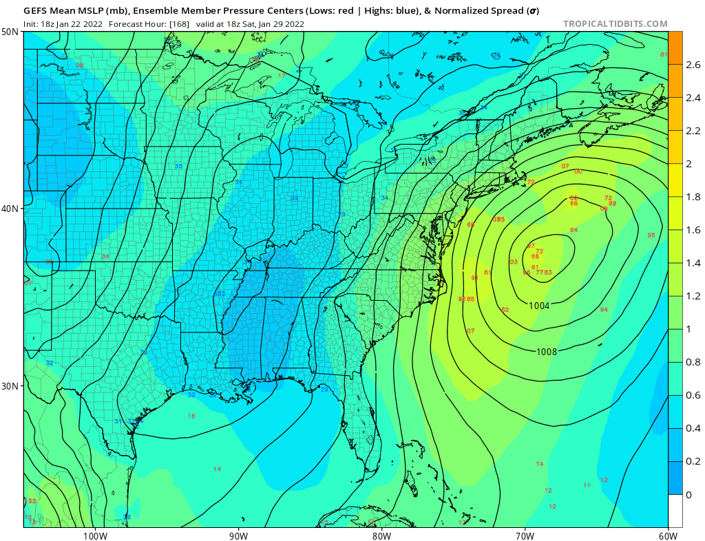
I wonder if the models are under doing the western extent of the precipitation. Seems under done for a sub 980 mb low.
-
 1
1
-
 1
1
-
-
As Forky suggested, let's wait until the wave arrives in the SW second half of tomorrow before getting excited or dejected. This is an important feature in the evolution of this storm.
-
1
-
-
2 minutes ago, nycsnow said:
Icon?
New England forum says ICON is way east.
-
1
-
 2
2
-
-
2 minutes ago, MJO812 said:
.thumb.png.ae7a5e31e171bd67eb2d3c3ae3ef6842.png)
Keeps hope alive for the Weenies!
-
I would sure like some more support for a KU from other models...
-
1
-
-
Before we get hopes too high, we need the other real models to output significant hits for the region. They are trending that way, but slowly. It was nice to see the 12Z RGEM handling the SW energy like the EURO.
-
 4
4
-
-
5 minutes ago, Blizzardo said:
Because the benchmark is too far east for NYC. We need it tucked inside to get burried!
January 26th, 2016 and January 4th, 2018 blizzards were south/east of the benchmark and unloaded on the region. Part of this is where the lows came from prior to arriving near the benchmark.
-
1
-
-
6 minutes ago, MJO812 said:
Cmc crushes eastern LI and eastern SNE. Further west than 0z.

952 mb near the benchmark. How doesn't this bury the metro?
-
1
-
-
4 minutes ago, Rjay said:
My first call

This you having fun with us or do you really think we get shafted again like 2015? Painful memories...
-
1
-
-
Anyone have a good rationale how this storm could develop a warm core as depicted by the EURO?
-
1
-
-
1 minute ago, Rjay said:
Nothing
Yeah...tenuous at 5 days out. Inland runner and whiff still on the table IMO. Whiff still my biggest concern...but we could all be hoping for an eastern correction in the days ahead. Still nice to see these runs tonight.
-
1
-
-
2 minutes ago, Rjay said:

What's to stop this from running inland? I know the Atlantic blocking isn't that strong...that's part of the answer.
-
Snow is mixing in Battery Park City.
-
FWIW - NAM outside of its useful range, looks more promising. I still don't like the placement of that high though.
-
-
10 minutes ago, n1vek said:
Agreed - GFS southernly trend is there comparing runs this morning. I don't have access to Euro maps, but hopefully OpenSnow posts some views this morning.
Link to free EURO site.
https://weather.us/model-charts/euro/2021031100/colorado/acc-total-precipitation/20210317-0000z.html
-
1
-
-
Just now, weatherfreeeeak said:
Any ideas for NYC and nearby Suburbs for when we expect the sleet to change back over to snow?
Still snowing in southern Manhattan...never stopped.
-
What are the odds that NYC breaks its all-time snowfall record?
-
That mixing line is sure racing north through NJ fast...
-
1
-
-
I think there are going to be some all time snowfall records toppled in the region this week.
-
1
-
-
06Z Para GFS would do just fine for about everyone. Model has been amazingly consistent.

-
1
-
-
5 minutes ago, jm1220 said:
This isn't really like Jan 2016. That was more miller A and El Nino fueled-you could track the moisture from it right to the tropical Pacific. This is more miller B-coastal transfer from a primary. It won't make it a lousy event but spawned differently.
Yeah... I'm not talking about all the meteorological mechanics (which are cool), but the geographic spread / depth of accumulations and long duration. Has still a ways to go though.
-
Some of the models tonight almost make this storm look like Jan 2016 redux.
-
1
-
-
6 minutes ago, sferic said:
Exception to that rule MARCH 2017
Yeah...always exceptions. I remember that one. I experienced my first thunder sleet. 2 inches of LE sleet. Still a pretty cool storm for many.
.png.ec293d59acc87dac2caacd2bfaca7b39.png)


.thumb.png.1e7f4c1e624bf96a3d887bed0275e611.png.520dca164777c0e580531ea6a75b05cd.png)
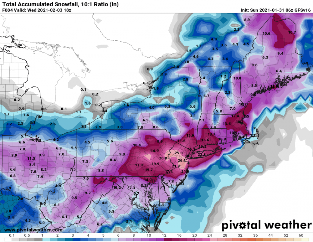
January 28-30th Possible Nor'easter
in New York City Metro
Posted
Fairly long duration as modeled.