

Metasequoia
-
Posts
660 -
Joined
-
Last visited
Content Type
Profiles
Blogs
Forums
American Weather
Media Demo
Store
Gallery
Posts posted by Metasequoia
-
-
8 minutes ago, tek1972 said:
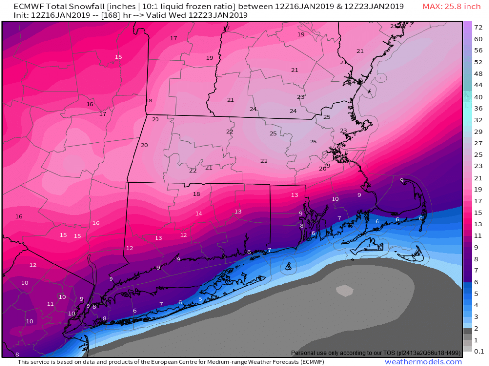
Euro still rain for the coast?
Sent from my SM-N960U using Tapatalk
Take a look...snow to rain.
https://weather.us/model-charts/euro/2019030112/new-jersey/significant-weather/20190304-0000z.html
-
 1
1
-
-
8 minutes ago, Snow88 said:
Alot of precip
You have a map of said alot of precip?
-
10 minutes ago, Stormlover74 said:
Ukie?
from NE forum (ORH_wxman)
looks good to me...
-
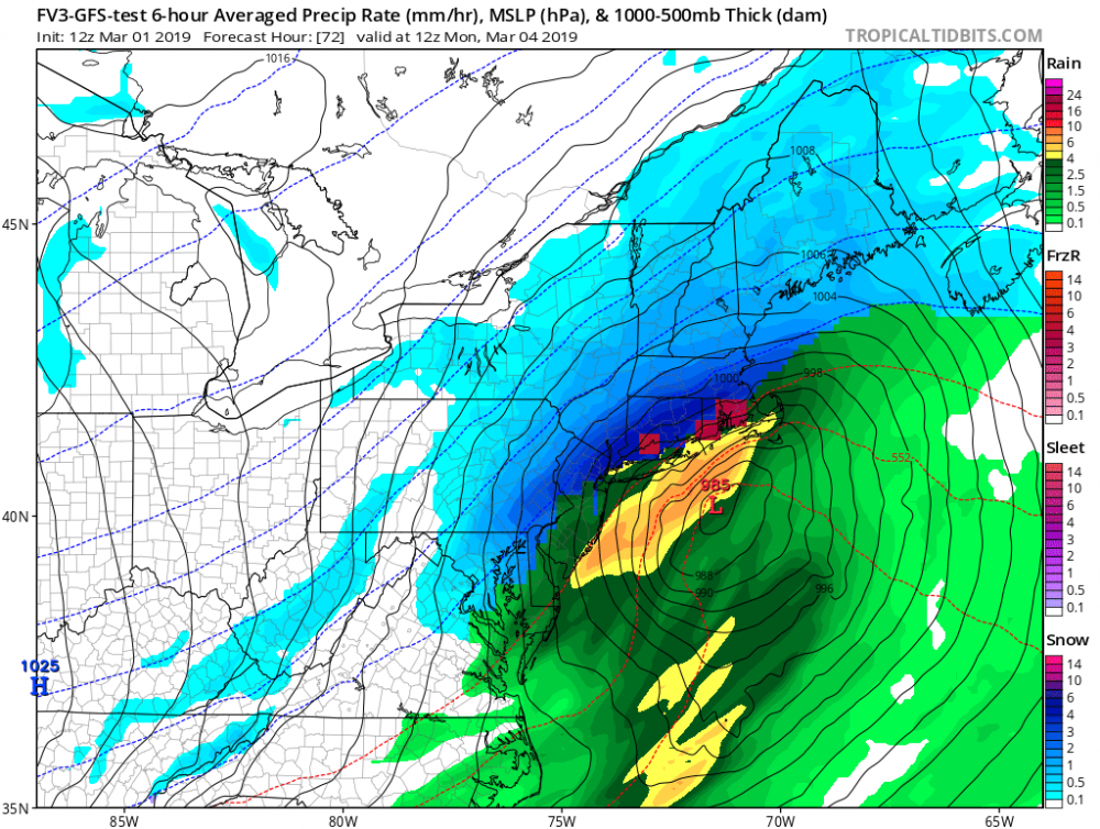
12Z FV3 is a big hit. Rain snow line is a bit too close for comfort though.
-
6 minutes ago, David-LI said:
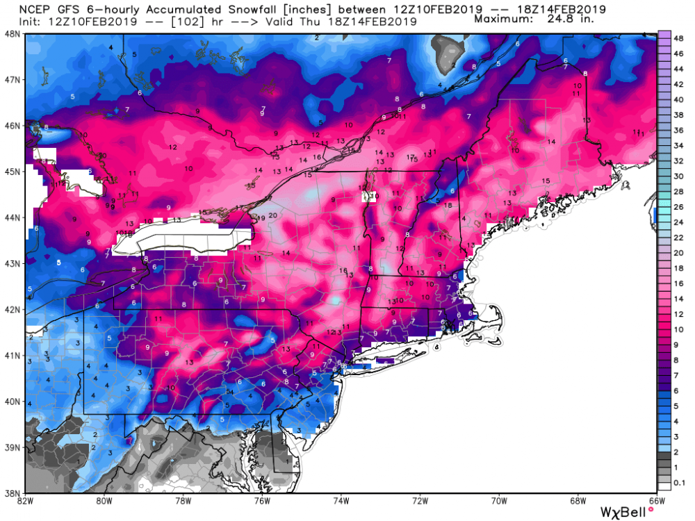
Could anyone post a more detailed snow map for last GFS run?

-
12Z NAM looks even better for Sunday night. Nice trends.
-
1
-
-
1 hour ago, Ericjcrash said:
If, and obviously a big if the fv3 is right and NYC can pick up 10" or so Sunday night and Monday NYC wouldn't be much below normal after all this complaining all winter lol. Euro looks like it came SE but I have horrible access... how did it look?
https://weather.us/model-charts/euro/2019030100/new-jersey/significant-weather/20190304-0400z.html
-
0Z EURO took another significant jump southeast. NYC is now half snow (front end) and half rain. 6Z NAM improved markedly...also snow to rain for NYC.
-
1
-
-
4 minutes ago, mikem81 said:
UKMET has been most consistent so far with the Sunday Night event. Last 3 runs all look very similiar
I want to believe the UKIE is right, but it has shown one pretty benchmark storm after another this Winter. I don't know how it gets such a high verification score.
-
1
-
-
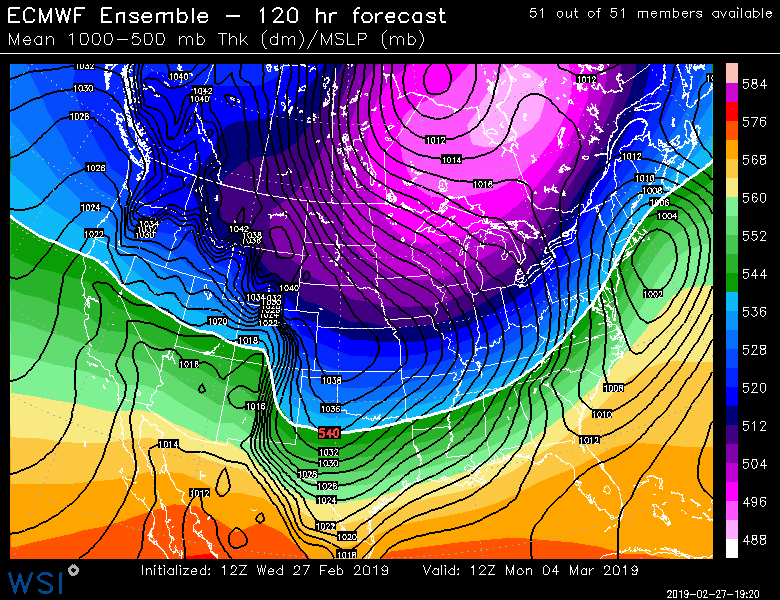
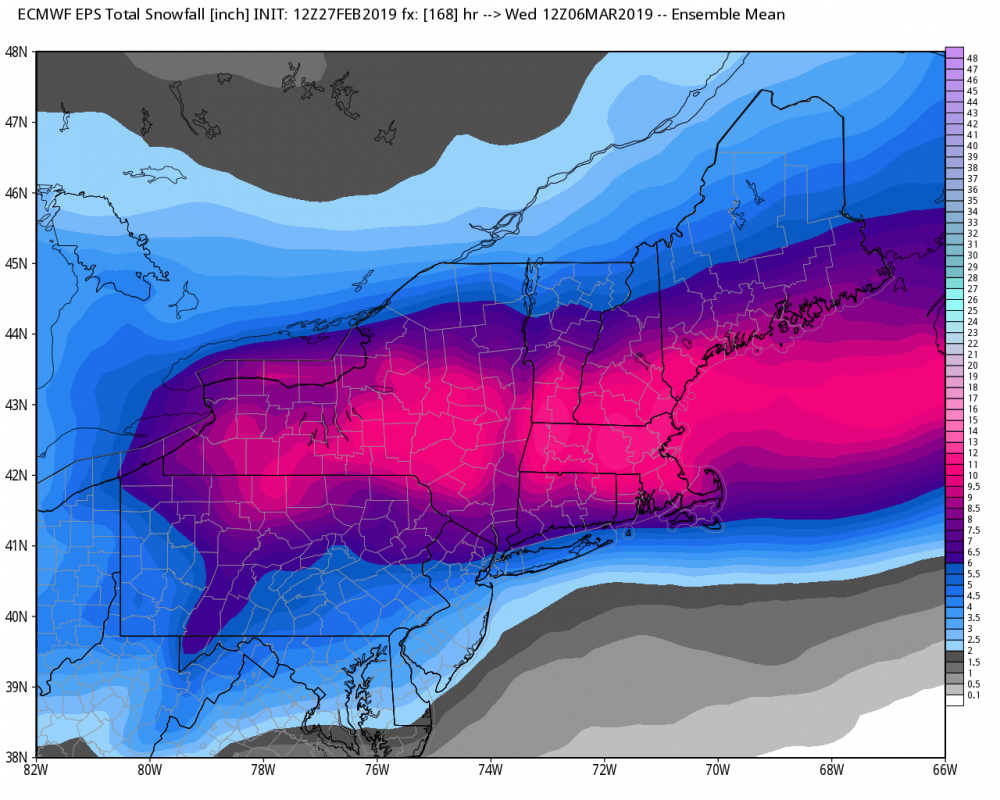
12Z EURO ensembles improved from 0Z...much better than operational run. Not a bad place to be 4 plus days out IMO.
-
1
-
-
Looks like NYC will have sleet until being dryslotted...then rain moves through.
-
I'll say. I do like sleet...not as much as snow though. Maybe it's my Catholic upbringing, but I like the sting a bit.
-
Yeah, many short range models indicate a "headfake", but the radar does look great. I was shocked when I looked...
-
2
-
-
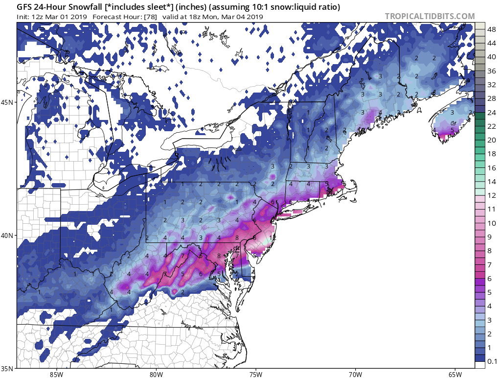
12Z GFS FWIW
-
4 minutes ago, Snow88 said:
Ukie has several inches of snow with a nice thump before temps warm.
Sounds like a reduction from the 0Z run...
-
Just now, RU848789 said:
Thanks - sorry to be a pain, but do you happen to have one that shows all of NJ?
Certainly not a pain. I unfortunately don't have access to these particular snow maps other than what the NE forum folks post.
-
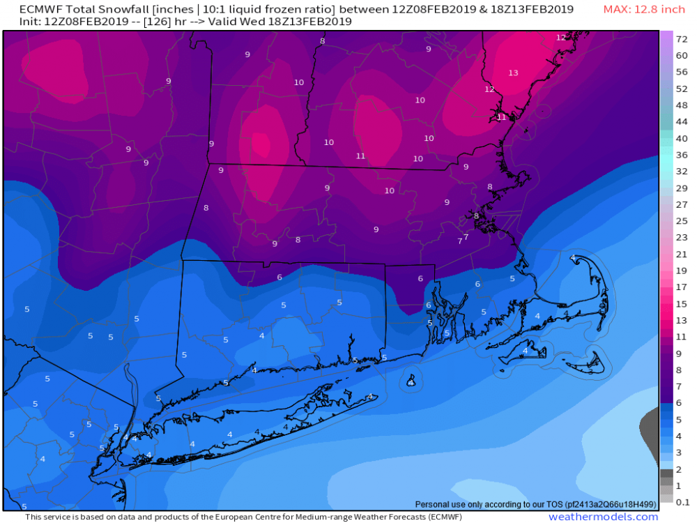
35 minutes ago, RU848789 said:
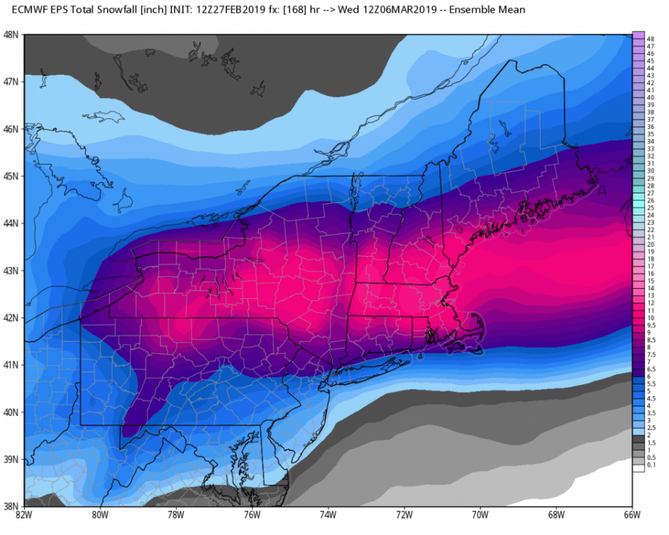
Anyone have the Euro snowfall map (looks like a general 3-5" for the 95 corridor/NYC, but I can't paste it from weather.us).
-
1
-
-
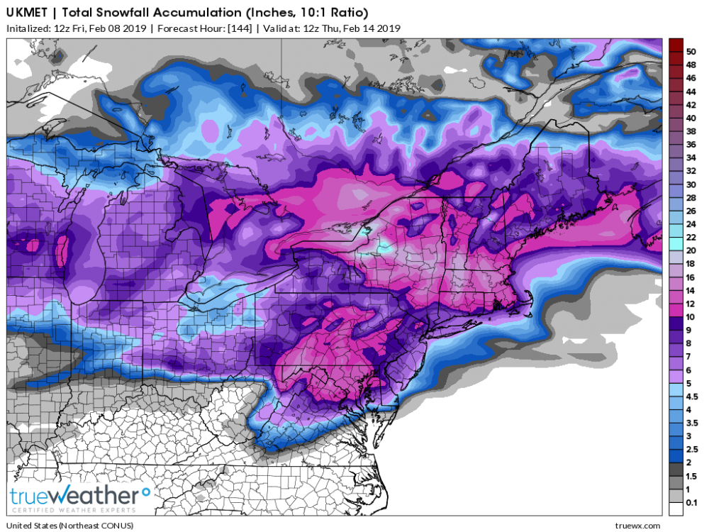
12Z UKIE
Lets see if we get support from EURO.
-
1
-
-
Just now, White Gorilla said:
Can we please stop with the "it is over" comments? I get the discouragement so far, but we have a long way to go and no matter what any model tells you today, it could flip 180 tomorrow.
Totally right. We are in the heart of Winter...February is historically a great month for snow and March is no slouch. Plus, backloaded Winters have been a common theme over the last half of this decade.
-
2
-
-
35 minutes ago, Snow88 said:
Gefs is colder and south.
Temps never get above freezing for NYC with 6 inches on the snow map.
You have a map for this you'd like to share?
-
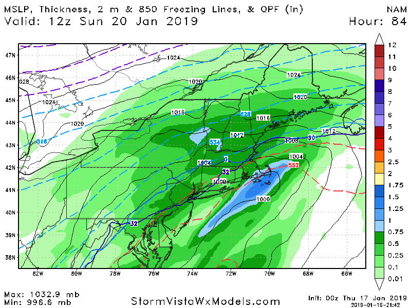
This looks very icy for NYC at the end of the NAM's run.
-
5 minutes ago, SnowGoose69 said:
This could easily go back north over the next 60 hours. As a matter of fact the storm that hit DCA just pretty much did that. Trended south from 120-84 then went 100 miles north after
...or continue its march south. I would think that every storm system is different.
-
 Non Kuchera prior to transition to freezing rain...
 -
9 minutes ago, NJwx85 said:
This is the warmest panel

Looks like parts of NYC are at or below freezing on this panel... Am I wrong on this?

March 3rd-4th Shellacking threat
in New York City Metro
Posted
I'm not sure when 6Z and 18Z EURO runs started, but they are a thing. The operational run only goes to 90 hours or so.