

Metasequoia
-
Posts
660 -
Joined
-
Last visited
Content Type
Profiles
Blogs
Forums
American Weather
Media Demo
Store
Gallery
Posts posted by Metasequoia
-
-
6 minutes ago, nycsnow said:
Still moving n/w (remember we really won’t need much of a n/w push up here to make a huge difference)
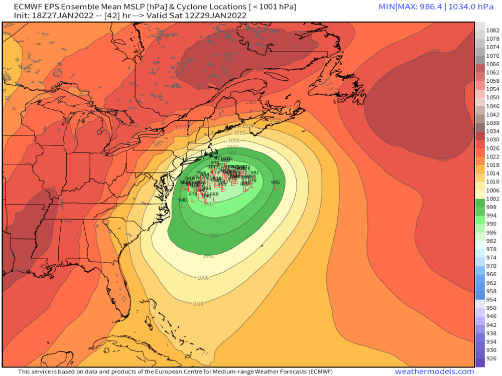
Pretty nice look and the low is only at 998 mb.
-
 1
1
-
-
Snow and wind are gradually increasing in intensity in lower Manhattan. Sidewalks are covered and sidestreets are mostly covered.
-
6 minutes ago, nycsnow said:
Steve d saying negative tilt 2 hours early, but feel like he says that every storm lol
I think it's a couple hours earlier than the NWS forecasted. Others feel free to correct me.
-
1
-
-
11 minutes ago, brooklynwx99 said:
gorgeous

Almost unbelievable.
-
2
-
-
34 minutes ago, Rjay said:
Did you did BOX's afd? I'd be losing my mind too.
It's all about expectations of course. This isn't the last model surprise. NOAA's forecast for New England might just verify in the end.
-
3 minutes ago, USCG RS said:
Seems to me that the Mets in the NE forum are all kinda pulling the plug.
NE folks were hoping for a record breaking storm, so I guess 12 to 18 inches seems lame to them.
-
1
-
-
3 minutes ago, wthrmn654 said:

Where do I sign?
-
1
-
-
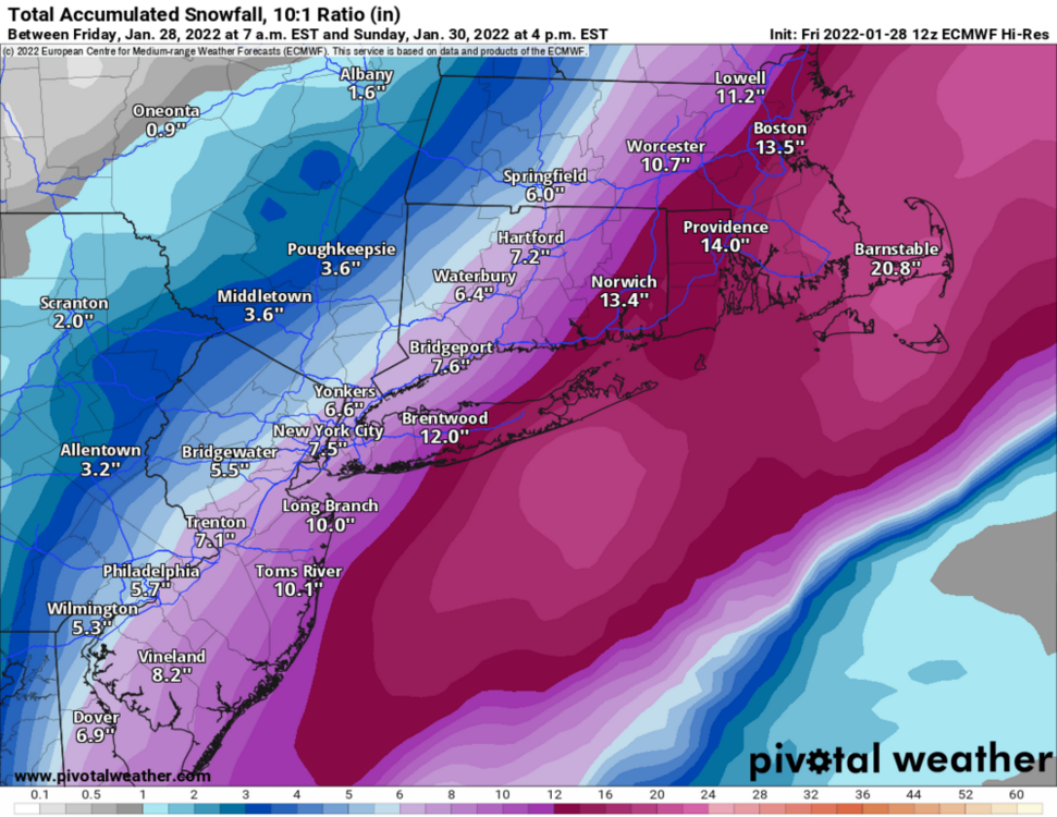
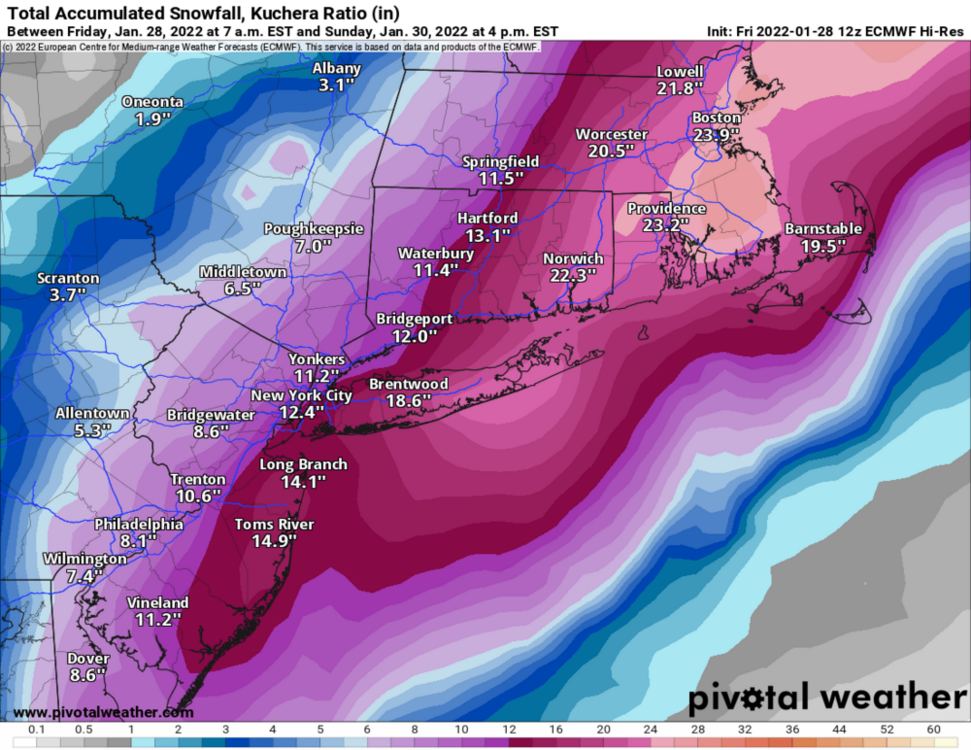
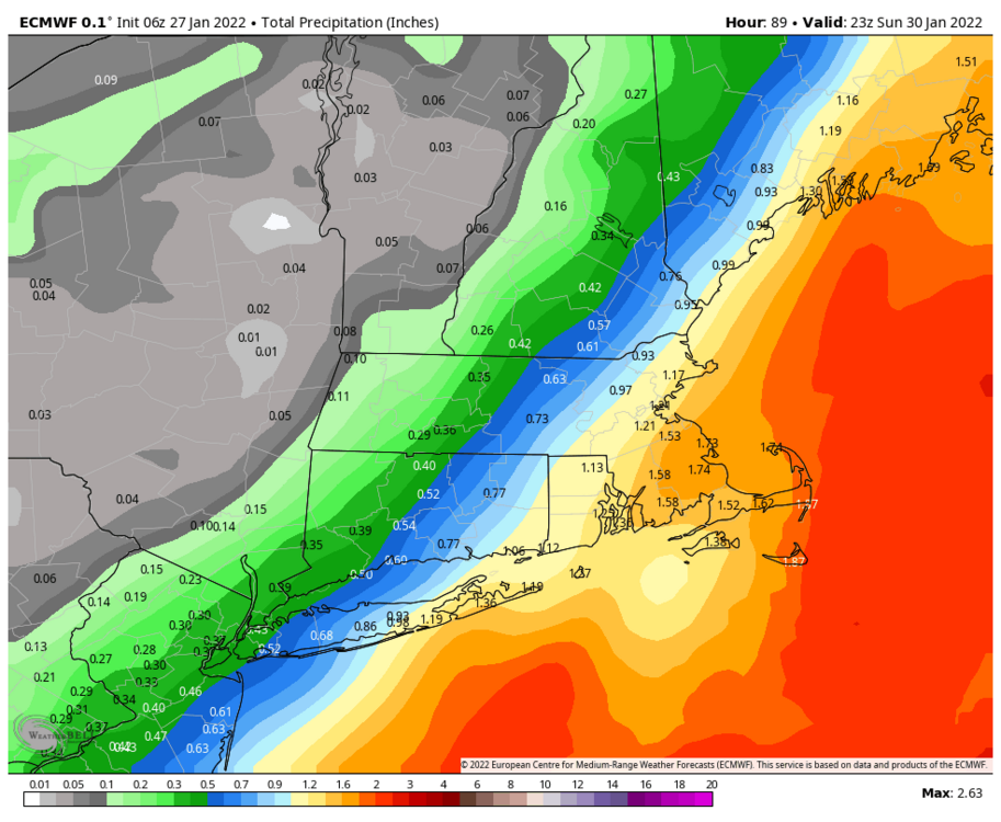
So the Euro shaved a couple of inches off on this last run. Still a nice hit for the metro and east.
EDIT - Also good to the south.
-
1
-
-
So, when should we ditch global models and pay attention to the medium and short range models?
-
1
-
-
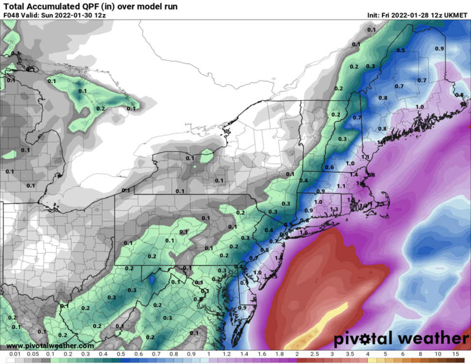
12 UKIE
-
1
-
-
-
I just doubt the weather models can accurately forecast the placement of the surface low or lows for this dynamic of a storm to our preferred tolerances. Classic now cast storm. It's going to snow pretty good regardless.
-
NAM is known for run to run inconsistency and this is a complex setup...
-
Interesting...
-
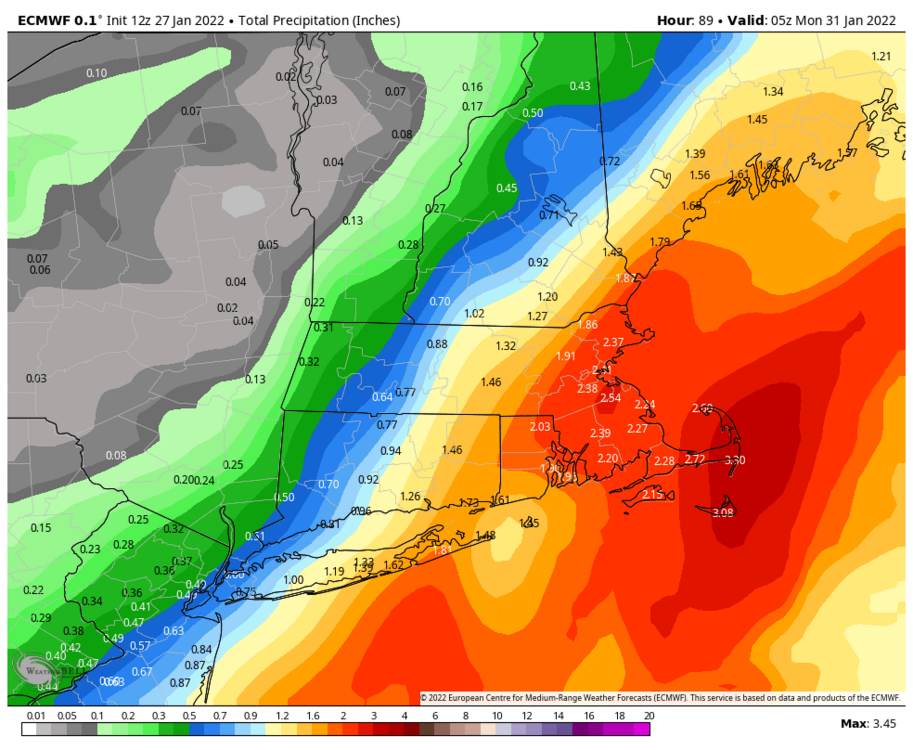
Euro has been looking better each run as of late.
-
3
-
-
Are ensembles of much use 24 hours before a storm?
-
I would really like to hear a mets perspective on this latest euro run.
-
1 minute ago, NJwx85 said:
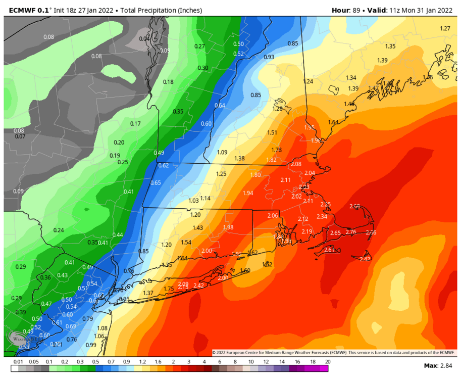
It actually looks like we're moving towards a consensus. Heaviest snow Eastern LI up into SE New England. Everyone else glancing blow. Don't think 6-10" is out of the question yet for NYC, especially given high ratios.
Seems like the timing and rate of intensification of the low will significantly determine snowfall. This is one of more difficult things to predict. I think we need more time to figure this out.
-
2 minutes ago, MJO812 said:
I'm going with 0-10 inches for NYC
I think 5 to 20 is on the table for NYC.
-
 1
1
-
-
Well...EURO is no longer the western most solution. That's quite the change.
-
1
-
-
8 minutes ago, larrye said:
Actually, even though the 00z NAM came back west, if I remember correctly ... it called out about 10" on LI and even less in NYC proper. And the NAM usually overstates QPF. Not exactly in agreement with with the UK and the Euro.
The precipitation shield to the north west of the low on the 0Z NAM just doesn't look right... looks too small for such a strong low. It's not like there's a monster high to the north.
-
3
-
-
4 minutes ago, IntenseBlizzard2014 said:
I've been tracking East Coast Winter Storms for quite a while, and what I've seen from the UKMET was quite an eye-opener.
That's only 12 hours of precip too by the looks of the map legend.
-
1
-
-
0Z CMC looks like 24 plus hours of snow, inline with its mesoscale brother.
-
3
-
-
1 minute ago, jm1220 said:
Doesn't really show the capture scenario so actually it could be longer if that happens.
Good point and all without significant blocking. I love a long duration snowstorm.


February 3-4 significant icing event for the interior, some sleet/snow possible. Coast mostly rain.
in New York City Metro
Posted
I prefer snow, but I like a good sleetstorm. It's like really low ratio snow...which will do. The 2017 half foot sleetstorm in NYC was epic.