

Rd9108
-
Posts
3,195 -
Joined
-
Last visited
Content Type
Profiles
Blogs
Forums
American Weather
Media Demo
Store
Gallery
Posts posted by Rd9108
-
-
Para gfs is a big hit for our area. Things are definitely interesting for Monday.
-
Gfs a little further south. Not a bad look at this range but let's see what it does once we within 48.
-
Just now, RitualOfTheTrout said:
Going to need a couple more nudges.. but Euro is the northern envelope of other guidance, so even a 70/30 split would probably be a solid hit.
It is almost sickening to keep seeing this type of track though! One of these years we have to get stuck in a setup that constantly bulls-eyes SWPA right? Right!? lol

Naw we know that's what will happen. It will keep trending south. We will get really excited, I'll start posting every model picture that Jack pots us. Then 48 hours out we will start getting a north trend and some models will give us hope but the GFS will show that exact outcome above. We will say the gfs is off its rocker, but in the end it will be right.
-
Well next threat looks like a slider. Sounds about right.
-
Not a bad event but kinda sad it's our biggest one this season with that being said a huge warm up coming. Then maybe just maybe one last hurah in March but at this point anything we get is usually gone pretty fast.
-
1 minute ago, MikeB_01 said:
Really coming down in the south hills. If you are not on the roads, it sure is puuurdy
Roads were terrible on my way home from work. Lucky I was going against traffic but I'm gonna have to cancel my dentist appointment this morning because there is no reason to be on the roads.
-
1 minute ago, KPITSnow said:
Man, the gfs seems to be completely on its own on this one. Can it be that far out to lunch?
It cant account for the heavier precip allowing it to stay snow. No way in hell its right whenever every single model is close to it atleast for WPA.
-
One thing for sure we may not get the accumulations that we want but we may have a good chance for some pretty heavy rates. That's why I want another 94 before a 93 just because the rates in that storm were so incredible yet I was only 3.
-
I tend to favor the least amount of snow in this scenario just because we dont hold onto cold all that well. Maybe the HRRR is onto something but if we somehow get more than 3 inches I'd be shocked.
-
1 minute ago, pasnownut said:
Ive spent less time in the MA forums, but i bet they are gettin a bit nervous.
They are and funny enough they were talking about whether someone was gonna hit 12+ just yesterday. Now they are freaking out that they may only see 3-5 and I'm over here hoping to beat our season high of 3.
-
 1
1
-
-
3 minutes ago, MikeB_01 said:
I think the NWS has a good handle on this one. 2-3 for AGC. If business is booming early on, then we might get 4. If its a bust, we are somewhere around 1. Also a chance for some freezing rain. Regardless, impacts for tomorrow morning's commute will be high.
Agreed. Right now the gfs is the warmest and is worst case. Curious to see if the euro holds serve. I'd be happy to somehow get 4 but I think 2-3 is the right call.
-
1 minute ago, KPITSnow said:
The NAM is slowly drifting further and further north...where have we seen this before.
It's the NAM and hasnt been very good.
-
From MAG. I'll be back for the NAM most likely pushing south as is the norm for us
The warm air will probably win out there as per usual but I think they have a decent shot at a few inches up front at least. Most of the model suite seems pretty supportive of that idea with the GFS being least so and the 18z NAM giving Pit a 6"+ event. To me this looks like a better setup for Pittsburgh metro than last week's storm. We don't have a strong defined low pressure to the lakes (there is still a low going west) and we have what should be a pretty sizeable wave of Gulf Moisture attacking the high pressure. This should deliver frozen up front in Pittsburgh and perhaps a pretty big portion of SW PA.
-
3
-
-
6 minutes ago, MAG5035 said:
The Euro is probably the best compromise of the two. NAM might be a little too amped up north. The GFS still focuses best snows in western/central MD, WV mountains and Northern VA. The Euro has it's best snow swath along the southern 1/3 to 1/2 of PA, which is probably closer to the NAM in terms of best snow axis. The NAM seems to really have a heavy front shot of snow, which I think is where the higher amounts are coming from. I like CTP's watch placement for now, I mentioned first thing this morning that I figured they would consider bottom two tiers up for watches and that's where we're at this afternoon. I also thought Horst's map was a pretty good take.
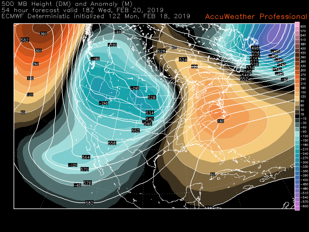
However significant our winter weather impacts end up being, I love the fact that this is our 500mb map at game time.
MAG do you think KPIT eeks out 4 or 5 or do you think the warm air is gonna win out as usual.
-
3k high rez has like 3-5 inches of course I'd air on the side of lower especially when it comes to CAD. Regardless maybe our biggest snowfall of the season coming.
-
To my untrained eyes NAM looks pretty good. We get a nice 3-6 thump (probably overdone with more sleet mixing) turning into freezing rain/mix and never change to plain rain.
-
10 minutes ago, MikeB_01 said:
Not a super deep DGZ but the omega is good. Should be coming down pretty good at that point. A nice front end thump
.At this point I just want to see some decent heavy snow even if the accumulations dont amount to a lot. I missed out on the death squall line a few weeks ago.
-
1
-
-
33 minutes ago, Burghblizz said:
New NAM looking a little colder on the front end
Just woke up from a nap and saw that myself. Maybe we can get lucky but the precip has to get in and out quick in order to get those heavy accumulations.
-
8 minutes ago, Superstorm said:
Euro looking good for WEDNESDAY event.

.What's the kuchera say. Cant trust a 10:1 ratio map especially when you guys are dealing with CAD. I fully expect my area to feel the effects of the warm tongue on this one.
-
Everything just trends worse and worse. It just doesnt want to snow here this winter. I'm really getting tired of the rain. It wouldn't be so bad if it didnt rain everytine we get any sort of moderate amount of moisture. At this point I'd love an outright torch but even with the south east ridge and Pacific trough trying to warm us up we still ride the boundary. Unfortunately I know how this is gonna play out. MJO is going into phase 8-1-2 in March and we get a late snow storm and a delayed spring.
-
I refuse to even entertain the snow maps.
-
Euro shows a hit blah blah. It wont play out that way. Warm tongue will win out. No reason it wouldn't just going on our season trend this winter.
-
This doesnt look good now. The thing that sucks is that instead of outright torching we may just ride the border of being too warm to snow and just get cold rain. Not to mention the south east ridge is showing up now and usually that doesnt bode well for us.
-
Well winter is coming back. We will be tracking starting this weekend. There's at least that.

✨Pittsburgh PA ❄ Winter 2018-2019
in Upstate New York/Pennsylvania
Posted
Up listening to the radio so I finally got to look at the 0z models. Euro looks great for a foot of snow but it's still a few days out and we could still see some changes.