

Rd9108
-
Posts
3,461 -
Joined
-
Last visited
Content Type
Profiles
Blogs
Forums
American Weather
Media Demo
Store
Gallery
Posts posted by Rd9108
-
-
12 minutes ago, Burghblizz said:
If you were hoping for some coastal love, the NAM won’t disappoint. Fires like 20” back to Indiana county -

Everywhere else around AGC foot-ish. Still trying to mix south a bit
Can it be game time already.
-

Wheres the excitement!!! It could happen.
-
 2
2
-
-
-
11 minutes ago, MAG5035 said:
12z Euro ensemble has 6" mean solidly back into the southern tier. Best that's looked since 12z yesterday.
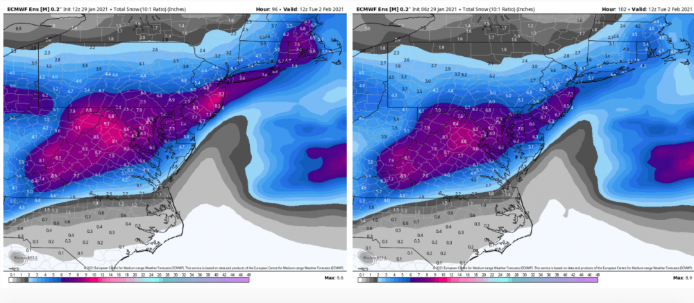
CTP with it's opening snowmap:

Looks like that shaft of ❄ is starting to get further into PA as well.
-
Not bad not bad. Still could improve too.

-
6 minutes ago, Burghblizz said:
Euro looking close to that same 8-9” type output in the city or just south - but instead of the snow hole over Morgantown, it has a 12” bullseye. And the totals trail off from the city north.
This really shows some of the complexity with track, temps, and the dry slot (which could hurt those borderline temps, in addition to less precip. So double whammy where that happens).Seems like the bleeding stopped on the Euro finally. This is such a complicated set up that I wouldn't be confident if I was forecasting. Id be happy with a 5-8 storm. At this point if it's not gonna be our next big daddy ill take every inch we can.
-
So gfs just absolutely floods the area with warm air. We would get a very slushy like 2-5 but maybe its wrong on the thermals. I'm betting huge on the NAM
-
-
So the NAM looks great but it has zero backing so I'm not buying it.
-
Just now, jwilson said:
Well, if we "lose" this storm, the GFS shows a massive Miller A under a banana high around the 10th-11th. Who wants to buy stock in that one now? Haha.
If its anything like Gamestop I'll buy into it.
-
2
-
-
Hopefully NAM holds the line. We need some good trends today with that primary.
-
Just now, Mailman said:
Euro seems to stay frozen the whole time for us. Not showing big totals here, but I won't complain about 4-6" from a Miller B.
This is also true. I meant game over for the big totals before.
-
Game over Euro looks more like the GFS with the faster dying primary.
-
11 minutes ago, RitualOfTheTrout said:
Ukmet looks decent, pretty similar to NAM.
.thumb.png.db887574d30214609e26c53a7370953e.png)
Euro should follow. So basically GFS is either gonna score a coup or its in lala land.
-
The differences are crazy.

-
Just now, north pgh said:
0Z Gfs gives central Ohio 2 inches. 0Z NAM gives same area 15 inches. Something’s gotta give.
Yeah I'm not getting my hopes up. Let's see what the Euro does.
-
17 minutes ago, Ahoff said:
SREF plumes not looking to good. Mean is barely of two inches, weird.
Hmm that is weird.
-
Just now, RitualOfTheTrout said:
ICON is drunk lol, 1.25in qpf in northern Allegheny. I don't follow it closely but I'd be willing to bet that is overdone.
Or just hear me out. Maybe it is right
-
Just now, ChalkHillSnowNut said:
Sucks for me in the laurels but yinz need to win another one!!
Hey maybe its an overperformer. Two double digit storms would be pretty awesome for us if it happens.
-
1
-
-
 still snowing too
-
1
-
-
Just now, Ahoff said:
Now I'm scared, lol. Aren't the off hours (6z and 18z), usually a bit weird vs. the 0z and 12z.
Not always.
-
Interstingly the euro primary was too far south this run and the very SW corner of the state gets pounded with the heavy swath of snow. Will be curious to see what the 00z does.
-
2 minutes ago, Mailman said:
GFS going the wrong way.
Pretty bad run all around. Still time to change.
-
2 minutes ago, Burghblizz said:
We’ve heard for years not to study the NAM at 84...but I’m gonna.
Def south, but almost looks like it wants to force that intial heavier snow south, and/or have it fizzle sooner.
Im OK with that look at this point - just seems like mixing is the bigger concern than full suppression
This far out I'd rather not be in the absolute bullseye on the NAM


.png.dd476cbf50aebf1ece4a351183ac72ef.png)
Western Pa / Pittsburgh area Winter Discussion ❄️☃️
in Upstate New York/Pennsylvania
Posted
He usually doesn't even know where Pitt is. He finally fixed it.