Rd9108
-
Posts
3,859 -
Joined
-
Last visited
Content Type
Profiles
Blogs
Forums
American Weather
Media Demo
Store
Gallery
Everything posted by Rd9108
-

Pittsburgh/Western PA WINTER ‘25/‘26
Rd9108 replied to Burghblizz's topic in Upstate New York/Pennsylvania
Dammit now we have to hear about how its never gonna snow again until it snows again.... -
Pittsburgh/Western PA WINTER ‘25/‘26
Rd9108 replied to Burghblizz's topic in Upstate New York/Pennsylvania
According to reports out of Kansas City forecasts have bust low. They received more snow than forecasted in some areas fwiw. -
Pittsburgh PA Fall 2025 Thread
Rd9108 replied to TheClimateChanger's topic in Upstate New York/Pennsylvania
Gfs looks good too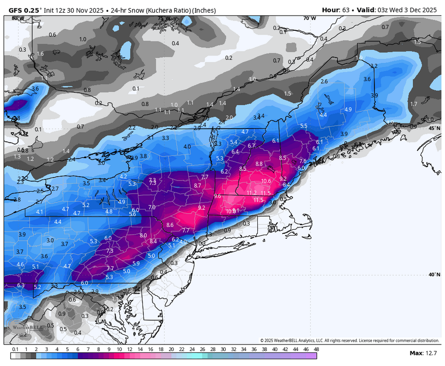
-
Pittsburgh PA Fall 2025 Thread
Rd9108 replied to TheClimateChanger's topic in Upstate New York/Pennsylvania
Its all about the banding whether we bust high or not. Short range models show a lot of the banding to be in the south west corner of the state. We shall see how everything sets up. Regardless "we should" see our first real snow accumulation for the season. -
Pittsburgh PA Fall 2025 Thread
Rd9108 replied to TheClimateChanger's topic in Upstate New York/Pennsylvania
NWS isnt as enthused as we are. Not surprised its a tricky set up and very progressive.
-
Pittsburgh PA Fall 2025 Thread
Rd9108 replied to TheClimateChanger's topic in Upstate New York/Pennsylvania
Idk about 3-5. I think 2-4 is a safe bet with 4 at the high end. Also Ritual sorry about your dog. Its tough losing a dog. Especially since they become part of the family. -
Pittsburgh PA Fall 2025 Thread
Rd9108 replied to TheClimateChanger's topic in Upstate New York/Pennsylvania
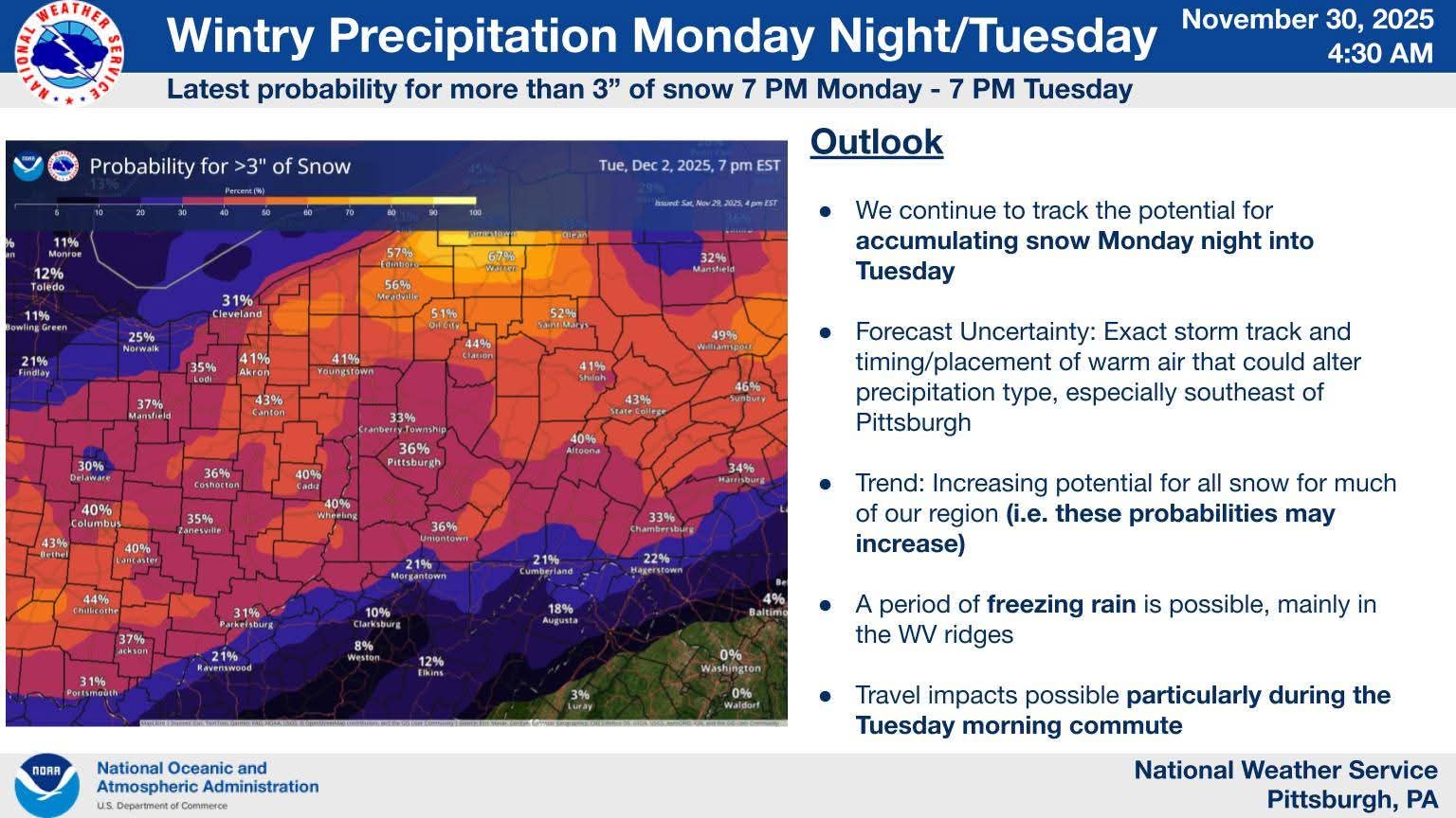
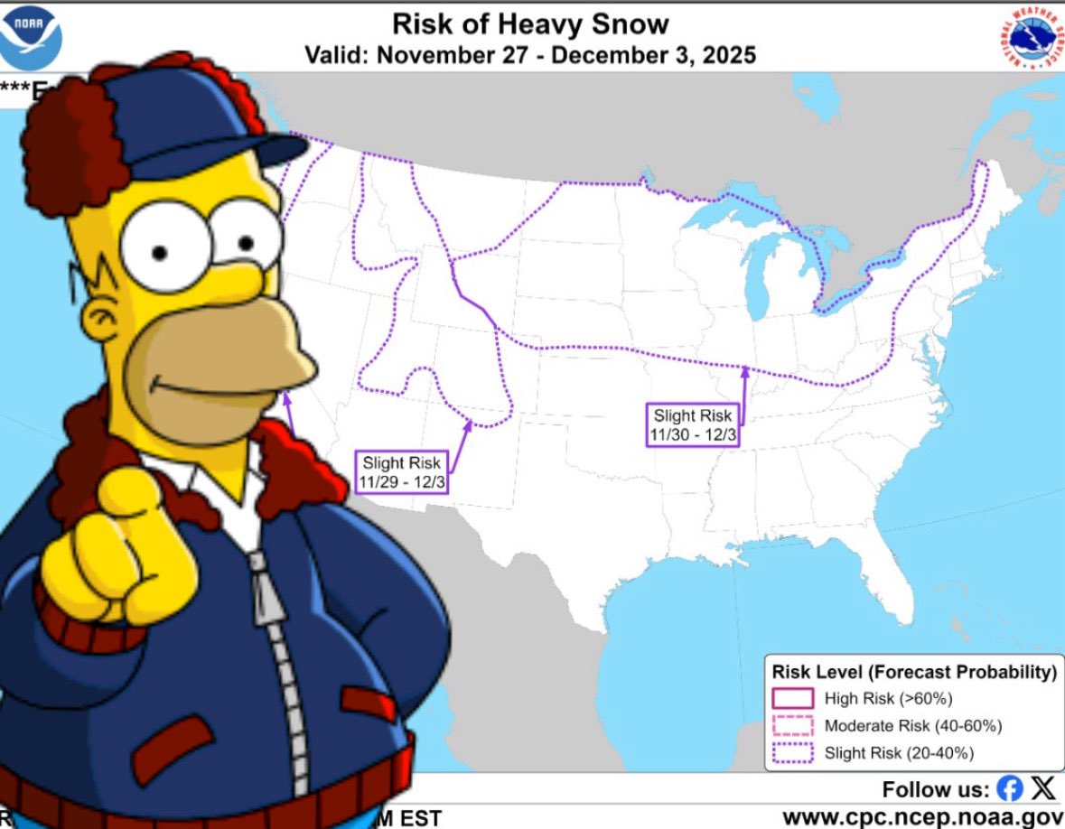
Depends on the model you look at. GFS is on its own with its NW solution. Most of the models have the weaker and south solutions. It's a fine line if we want better snows. Regardless as of now it looks like tuesday has a high potential to give us pur first real accumulating snow. -
Pittsburgh PA Fall 2025 Thread
Rd9108 replied to TheClimateChanger's topic in Upstate New York/Pennsylvania
Yeah I dont trust that we just miss on the system. Early in the season so any snow is a bonus. Sunday maybe a mess for a bit before the changeover. NAM shows it barely getting above freezing when the best precip is in the area. We know how the warmth always seems to win though. -
Pittsburgh PA Fall 2025 Thread
Rd9108 replied to TheClimateChanger's topic in Upstate New York/Pennsylvania
Be careful out there. Accidents everywhere, ice everywhere. I had to ditch my car and walk a few minutes to get to my house. -
Pittsburgh PA Fall 2025 Thread
Rd9108 replied to TheClimateChanger's topic in Upstate New York/Pennsylvania
Ill be the one to post the first weenie map of the season. Sure it will change 15 times between now and then.
-
Pittsburgh PA Fall 2025 Thread
Rd9108 replied to TheClimateChanger's topic in Upstate New York/Pennsylvania
Eventually it breaks. You know these things go in cycles. -
Pittsburgh PA Fall 2025 Thread
Rd9108 replied to TheClimateChanger's topic in Upstate New York/Pennsylvania
Pattern looks to be shaping up for the coming weeks for below average temps. The risk for winter weather should increase. Just like the Pirates signing a notable free agent Ill believe it when it happens.
-
Pittsburgh PA Fall 2025 Thread
Rd9108 replied to TheClimateChanger's topic in Upstate New York/Pennsylvania
Hurts a lot less in November but its funny seeing snow in Charlotte and not here. Just give me a great December-January and I'll be happy. -
Pittsburgh PA Fall 2025 Thread
Rd9108 replied to TheClimateChanger's topic in Upstate New York/Pennsylvania
High-end is 4 now. Who is ready to start the winter thread! -
Im totally trolling when I say OTS. What I will say is we've seen tropical systems have a mind of their own and drift further west than guidance. I wouldn't take any model verbatim.
-
That's what im saying. Its a fish storm.
-
Another bust and OTS she goes.
-
Looks like another fish storm
-
I know you guys complain about underperforming temps all the time but fuck this. Its hot and miserable.
-
I think it was more so the wind and rain that made it miserable. Had a golf outing and I was freezing.
-
This system has reminded me alot of or big snow storm misses. Most of the counties below AGH have seen almost .5 already while AGH is like .04 or something really small.
-
I was just south of the Butler tornado warned storm right around Suncrest golf course. The sky looked crazy, luckily once I got onto 228 it cleared up but I guess I just missed that one.
-
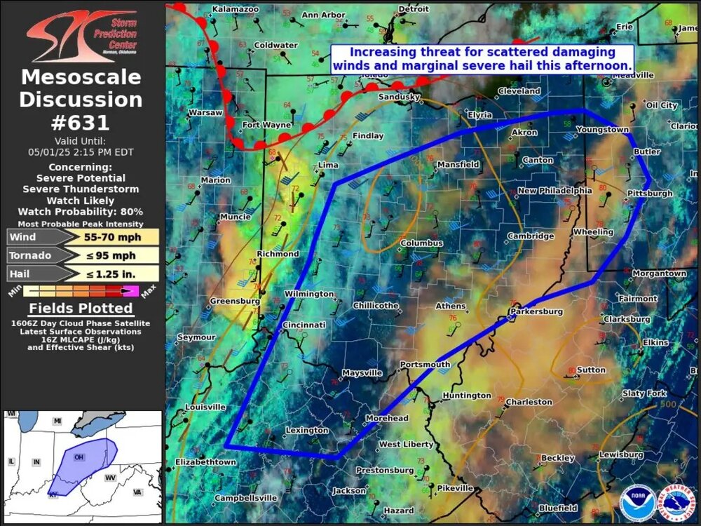
Another day and another chance for severe. Yesterday stayed west and east so hopefully the same happens. There's still lines and trees down all over the city.
-
Just driving around yesterday I saw a lot of trees that are about to fall but still hanging on. Hopefully the severe doesn't pan out.
-