Blizzard of 93
-
Posts
12,893 -
Joined
-
Last visited
Content Type
Profiles
Blogs
Forums
American Weather
Media Demo
Store
Gallery
Everything posted by Blizzard of 93
-
Central PA Winter 2024/2025
Blizzard of 93 replied to Voyager's topic in Upstate New York/Pennsylvania
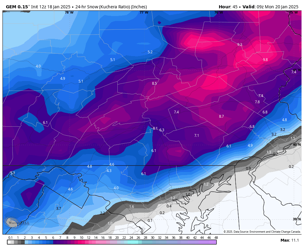
0z HRDPS short res Canadian looks good for the LSV as well. -
Central PA Winter 2024/2025
Blizzard of 93 replied to Voyager's topic in Upstate New York/Pennsylvania
I’ve seen too much over the years at MDT… Put me down for 4.9” & .39 precip. -
Central PA Winter 2024/2025
Blizzard of 93 replied to Voyager's topic in Upstate New York/Pennsylvania
0z Canadian is similar to the GFS in the LSV.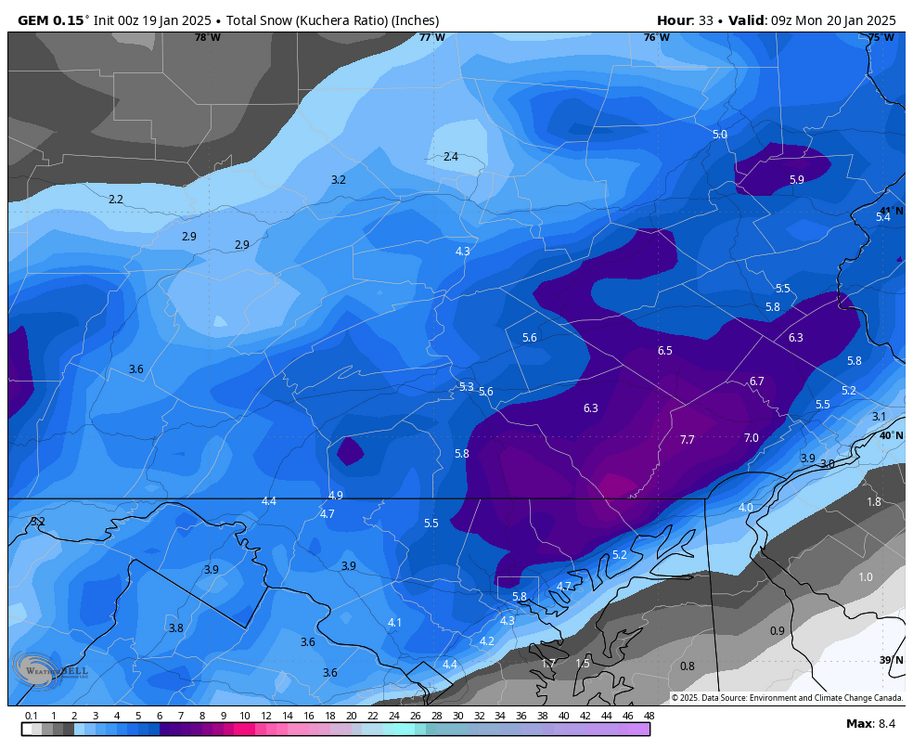
-
Central PA Winter 2024/2025
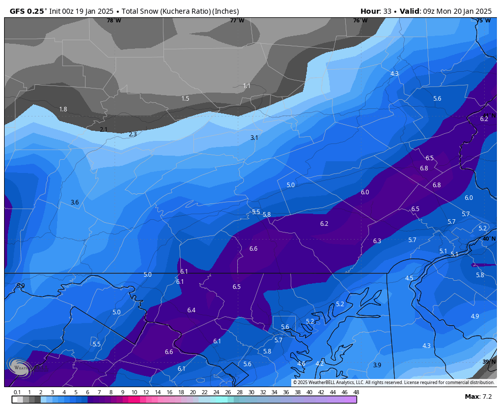
Blizzard of 93 replied to Voyager's topic in Upstate New York/Pennsylvania
GFS stepped up a bit over its 18z run for most of the LSV.
-
Central PA Winter 2024/2025
Blizzard of 93 replied to Voyager's topic in Upstate New York/Pennsylvania
Another solid RGEM run. -
Central PA Winter 2024/2025
Blizzard of 93 replied to Voyager's topic in Upstate New York/Pennsylvania
Solid run & I only have 10-1 -
Central PA Winter 2024/2025
Blizzard of 93 replied to Voyager's topic in Upstate New York/Pennsylvania
Fantastic photo. Yes, the ice was impressive looking out as I drove through Wormleysburg this afternoon. Just imagine what the ice will look like after the frigid temps this week! -
Central PA Winter 2024/2025
Blizzard of 93 replied to Voyager's topic in Upstate New York/Pennsylvania
This is Ellinwood from the MA thread who is a very good long time forecaster.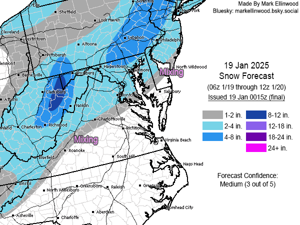
-
Central PA Winter 2024/2025
Blizzard of 93 replied to Voyager's topic in Upstate New York/Pennsylvania
-
Central PA Winter 2024/2025
Blizzard of 93 replied to Voyager's topic in Upstate New York/Pennsylvania
This is what I’m waiting for to make my prediction…
-
Central PA Winter 2024/2025
Blizzard of 93 replied to Voyager's topic in Upstate New York/Pennsylvania
We are in the main swath of good precip, Winners & losers will come down to banding. -
Central PA Winter 2024/2025
Blizzard of 93 replied to Voyager's topic in Upstate New York/Pennsylvania
Here’s CTP’s latest Expected map as of 7:16 pm….. -
Central PA Winter 2024/2025
Blizzard of 93 replied to Voyager's topic in Upstate New York/Pennsylvania
21z National blend of models. -
Central PA Winter 2024/2025
Blizzard of 93 replied to Voyager's topic in Upstate New York/Pennsylvania
18z RGEM -
Central PA Winter 2024/2025
Blizzard of 93 replied to Voyager's topic in Upstate New York/Pennsylvania
Only 1 point back of the last Wild card spot now. -
Central PA Winter 2024/2025
Blizzard of 93 replied to Voyager's topic in Upstate New York/Pennsylvania
You stole my number… darn it! -
Central PA Winter 2024/2025
Blizzard of 93 replied to Voyager's topic in Upstate New York/Pennsylvania
Lol, can we make the cutoff 12:30 am tonight so I can see the 0z Euro before my entry…? DT taught me to just use what the Euro says…Lol -
Central PA Winter 2024/2025
Blizzard of 93 replied to Voyager's topic in Upstate New York/Pennsylvania
Indeed -
Central PA Winter 2024/2025
Blizzard of 93 replied to Voyager's topic in Upstate New York/Pennsylvania
Very good 12z HRDPS short range Canadian -
Central PA Winter 2024/2025
Blizzard of 93 replied to Voyager's topic in Upstate New York/Pennsylvania
The 12z Canadian agrees.
-
Central PA Winter 2024/2025
Blizzard of 93 replied to Voyager's topic in Upstate New York/Pennsylvania
Very nice low placement for a Warning level event for us. -
Central PA Winter 2024/2025
Blizzard of 93 replied to Voyager's topic in Upstate New York/Pennsylvania
Yes, it now looks more like other guidance for the LSV. -
Central PA Winter 2024/2025
Blizzard of 93 replied to Voyager's topic in Upstate New York/Pennsylvania
Indeed, best run yet for Harrisburg & I only have 10-1 map -
Central PA Winter 2024/2025
Blizzard of 93 replied to Voyager's topic in Upstate New York/Pennsylvania
Yes, good thing the up & coming US short range model looks like other guidance.
-
Central PA Winter 2024/2025
Blizzard of 93 replied to Voyager's topic in Upstate New York/Pennsylvania
The 6z Euro AI may have had its best run yet for precip in southern PA Widespread over .50 of precip in the LSV with ratios would be a nice warning event for most.