Blizzard of 93
-
Posts
12,844 -
Joined
-
Last visited
Content Type
Profiles
Blogs
Forums
American Weather
Media Demo
Store
Gallery
Everything posted by Blizzard of 93
-
Central PA Winter 25/26 Discussion and Obs
Blizzard of 93 replied to MAG5035's topic in Upstate New York/Pennsylvania
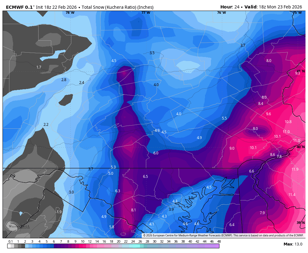
One last look at the 18z Euro for this event still gets 4 to 6 inches to the LSV by tomorrow morning.
-
Central PA Winter 25/26 Discussion and Obs
Blizzard of 93 replied to MAG5035's topic in Upstate New York/Pennsylvania
Finally flipped back to snow in Marysville. My temp is down to 33 -
Central PA Winter 25/26 Discussion and Obs
Blizzard of 93 replied to MAG5035's topic in Upstate New York/Pennsylvania
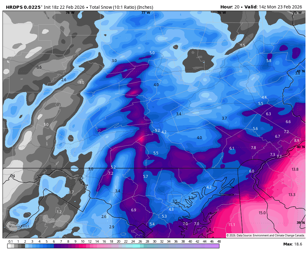
18z High res short range Canadian HRDPS has the inverted trough band right in the west shore of Harrisburg really close to RT. 15 It shows 5 inches for Harrisburg by tomorrow morning.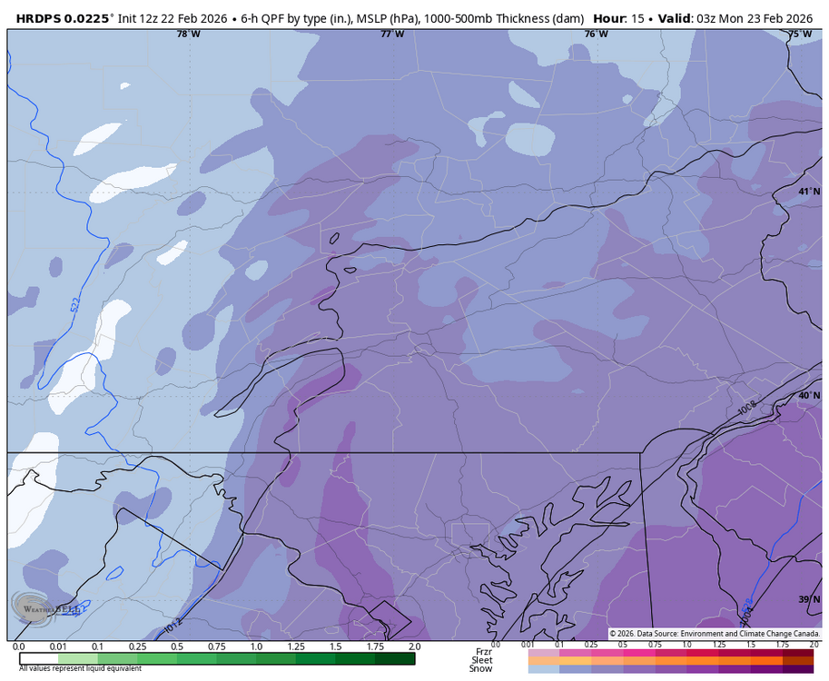

-
Central PA Winter 25/26 Discussion and Obs
Blizzard of 93 replied to MAG5035's topic in Upstate New York/Pennsylvania
It is remarkable in all of the wrong ways, lol! -
Central PA Winter 25/26 Discussion and Obs
Blizzard of 93 replied to MAG5035's topic in Upstate New York/Pennsylvania
Yes, the radar is showing heavier precip is starting to pivot into southeast York & eastern Lanco backing to the west. -
Central PA Winter 25/26 Discussion and Obs
Blizzard of 93 replied to MAG5035's topic in Upstate New York/Pennsylvania
It’s all about rates, as soon as we get under good bands, we too will snow. -
Central PA Winter 25/26 Discussion and Obs
Blizzard of 93 replied to MAG5035's topic in Upstate New York/Pennsylvania
I’m really happy that I’m using the ignore feature… if no one quotes them, I’ll never see the posts, lol! -
Central PA Winter 25/26 Discussion and Obs
Blizzard of 93 replied to MAG5035's topic in Upstate New York/Pennsylvania
If anyone wants to cheer up a bit before whatever happens tonight, go check out the 12z Euro full 15 day run. It shows multiple Winter storm chances including a Clipper Tuesday night & another system Thursday pm that is snow to a mix this run. Then more winter storm chances the first week of March. -
Central PA Winter 25/26 Discussion and Obs
Blizzard of 93 replied to MAG5035's topic in Upstate New York/Pennsylvania
Plenty of time to still score something with this event. We were never really in the bullseye, but let’s let it play out. -
Central PA Winter 25/26 Discussion and Obs
Blizzard of 93 replied to MAG5035's topic in Upstate New York/Pennsylvania
There ever changing computer generated maps are besides the point. Their actual written Warning says 3 to 8 for all of southern PA in CTP territory. -
Central PA Winter 25/26 Discussion and Obs
Blizzard of 93 replied to MAG5035's topic in Upstate New York/Pennsylvania
Look at my full screen shot time…2:20 pm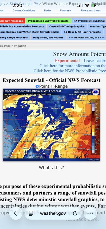
-
Central PA Winter 25/26 Discussion and Obs
Blizzard of 93 replied to MAG5035's topic in Upstate New York/Pennsylvania
Go look again… -
Central PA Winter 25/26 Discussion and Obs
Blizzard of 93 replied to MAG5035's topic in Upstate New York/Pennsylvania
Let the chips fall where they may… My trusty handbook says it’s now casting time! -
Central PA Winter 25/26 Discussion and Obs
Blizzard of 93 replied to MAG5035's topic in Upstate New York/Pennsylvania
Again, long way to go with this one… -
Central PA Winter 25/26 Discussion and Obs
Blizzard of 93 replied to MAG5035's topic in Upstate New York/Pennsylvania
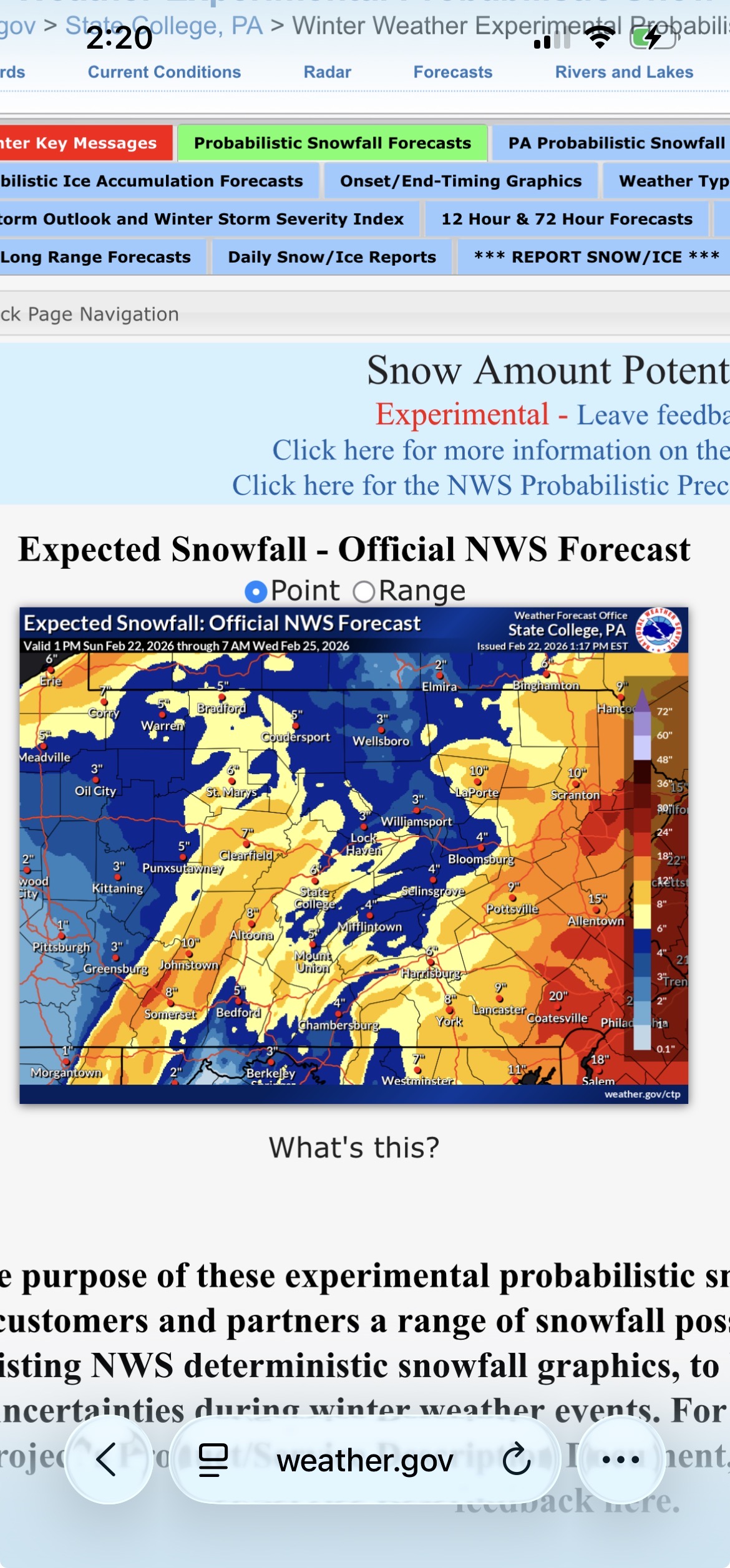
CTP updated expected snow -
Central PA Winter 25/26 Discussion and Obs
Blizzard of 93 replied to MAG5035's topic in Upstate New York/Pennsylvania
CTP just updated the Warning for most of us & downgraded amounts. Winter Storm Warning URGENT - WINTER WEATHER MESSAGE National Weather Service State College PA 133 PM EST Sun Feb 22 2026 PAZ056>059-063>066-231145- /O.CON.KCTP.WS.W.0002.000000T0000Z-260223T1800Z/ Perry-Dauphin-Schuylkill-Lebanon-Cumberland-Adams-York-Lancaster- Including the cities of Pottsville, Newport, Lebanon, Harrisburg, York, Hershey, Carlisle, Gettysburg, and Lancaster 133 PM EST Sun Feb 22 2026 ...WINTER STORM WARNING REMAINS IN EFFECT UNTIL 1 PM EST MONDAY... * WHAT...Heavy snow. Additional snow accumulations between 3 and 8 inches. Winds gusting as high as 40 mph. * WHERE...A portion of central Pennsylvania. * WHEN...Until 1 PM EST Monday. * IMPACTS...The strong winds and weight of snow on tree limbs may down power lines and could cause sporadic power outages. Travel could be very difficult. The hazardous conditions could impact the Monday morning commute. * ADDITIONAL DETAILS...Rain will change to snow this afternoon which will increase in intensity this evening and into the overnight hours. The heaviest snowfall is expected in eastern portions of Lancaster, Lebanon, and Schuylkill Counties. -
Central PA Winter 25/26 Discussion and Obs
Blizzard of 93 replied to MAG5035's topic in Upstate New York/Pennsylvania
12z Euro still brings 5 inches to Harrisburg & that inverted trough max line area is creeping towards Harrisburg & York this run.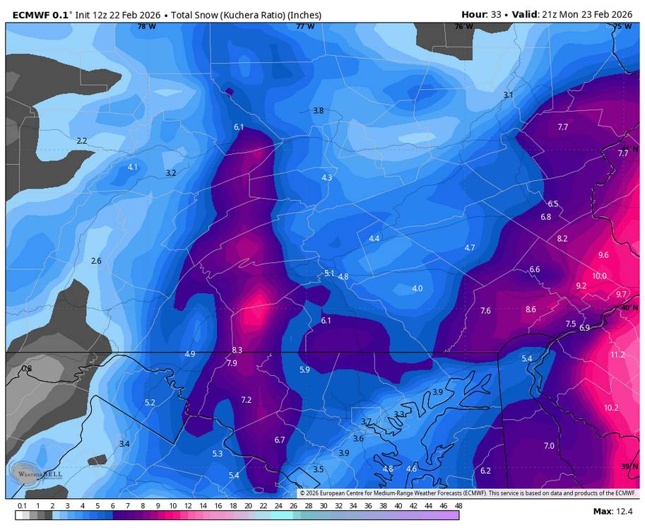
-
Central PA Winter 25/26 Discussion and Obs
Blizzard of 93 replied to MAG5035's topic in Upstate New York/Pennsylvania
Great advice from a pro a few minutes ago… @MillvilleWx said: “Everything is going as planned. Accums won't really start for another 3-5 hrs, especially after sunset. Temps will drop to near and below freezing and rates will increase. The ULL formation to our south has not even started yet. Hours to go before the good stuff. Go out, grab a bite, have a drink or two, relax, take a nap, celebrate the USA Gold, then enjoy snow falling later. It'll do what it's going to do. Everyone stay safe, especially our Delmarva brethren.” -
Central PA Winter 25/26 Discussion and Obs
Blizzard of 93 replied to MAG5035's topic in Upstate New York/Pennsylvania
I might need to check out for awhile, the emotional roller coaster by some on here is kind of unbearable. -
Central PA Winter 25/26 Discussion and Obs
Blizzard of 93 replied to MAG5035's topic in Upstate New York/Pennsylvania
Why? Because of the NAM, lol! Try to let the event play out… -
Central PA Winter 25/26 Discussion and Obs
Blizzard of 93 replied to MAG5035's topic in Upstate New York/Pennsylvania
CTP “Expected Snow” map issued at 9:15 which is typically conservative, shows 7 to 9 for Harrisburg, York & Lanco. -
Central PA Winter 25/26 Discussion and Obs
Blizzard of 93 replied to MAG5035's topic in Upstate New York/Pennsylvania
The NBM at 12z still matches the CTP Warning. -
Central PA Winter 25/26 Discussion and Obs
Blizzard of 93 replied to MAG5035's topic in Upstate New York/Pennsylvania
A few random thoughts before the real fun gets underway a little later: -I like that the storm is taking its time developing the precip shield. This should bode well for later on. -I like seeing the development of the precip shield with an increasing south to north orientation. -I like seeing the western extent of the precip shield back to the Ohio border. -inverted trough snow bands notoriously shift to the east at game time as @psuhoffman has mentioned this week. I like seeing this band modeled just to the west of the LSV main corridor at this point. The Harrisburg & York crew just need a slight adjustment east to get into the goods. -
Central PA Winter 25/26 Discussion and Obs
Blizzard of 93 replied to MAG5035's topic in Upstate New York/Pennsylvania
Large snow flakes are starting to mix in here now in Marysville as the heavier band approaches. I woke up about an hour ago to light snow & light rain mix. -
Central PA Winter 25/26 Discussion and Obs
Blizzard of 93 replied to MAG5035's topic in Upstate New York/Pennsylvania
Lol, good morning, many of us were up late tracking. The main show begins a little later on.