Blizzard of 93
-
Posts
12,938 -
Joined
-
Last visited
Content Type
Profiles
Blogs
Forums
American Weather
Media Demo
Store
Gallery
Everything posted by Blizzard of 93
-
Central PA Spring 2026 Discussion/Obs Thread
Blizzard of 93 replied to Voyager's topic in Upstate New York/Pennsylvania
Thanks, appreciate it! -
Central PA Spring 2026 Discussion/Obs Thread
Blizzard of 93 replied to Voyager's topic in Upstate New York/Pennsylvania
Thanks for thinking of me! We had indoor softball practice for my daughter’s team in the middle of nowhere Perry county with no cell service. The tornado warning was issued right before we started practice. Luckily where we were, there was no bad storm! Everything was good when we got back to Marysville Borough. I’m not sure what part of Marysville that it specifically hit. -
Central PA Spring 2026 Discussion/Obs Thread
Blizzard of 93 replied to Voyager's topic in Upstate New York/Pennsylvania
This type of scenario with some back end snow has been showing on many models the last couple of days. Maybe we see at least a little snow TV in the LSV? -
Central PA Spring 2026 Discussion/Obs Thread
Blizzard of 93 replied to Voyager's topic in Upstate New York/Pennsylvania
Lol, all that NE thread does is constantly stir the pot & bicker with each other. I try to sift through it from time to time, mostly to see a few knowledgeable quality long time poster’s thoughts. Most of it is short post nonsense that adds no value. They are more there to piss each other off than to talk about weather, it seems most of the time. NYC thread is similar. It’s a shame how Anthony gets treated on there. -
Central PA Spring 2026 Discussion/Obs Thread
Blizzard of 93 replied to Voyager's topic in Upstate New York/Pennsylvania
Surprising low of 32 this morning in Marysville. I am looking forward to our warm up the next few days. -
Central PA Spring 2026 Discussion/Obs Thread
Blizzard of 93 replied to Voyager's topic in Upstate New York/Pennsylvania
Don’t worry, next model run they will change their tune, lol, they waffle just like everyone else. -
Central PA Spring 2026 Discussion/Obs Thread
Blizzard of 93 replied to Voyager's topic in Upstate New York/Pennsylvania
The best part about this 18z GFS run is that it joined the other globals by showing a chance around St. Patty’s Day. Snow is for that 3 day period. -
I would pay some real money to see the 18z GFS verify, heck even half of it would be awesome.
-
Central PA Spring 2026 Discussion/Obs Thread
Blizzard of 93 replied to Voyager's topic in Upstate New York/Pennsylvania
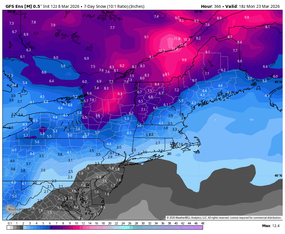
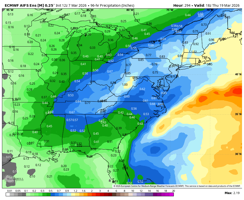
I would pay some real money to see the 18z GFS verify, heck even half of it would be awesome. Here is the full run 18z run snow through day 16, just for fun of course… -
Central PA Spring 2026 Discussion/Obs Thread
Blizzard of 93 replied to Voyager's topic in Upstate New York/Pennsylvania
It got absolutely beautiful out this afternoon when the skies finally cleared! -
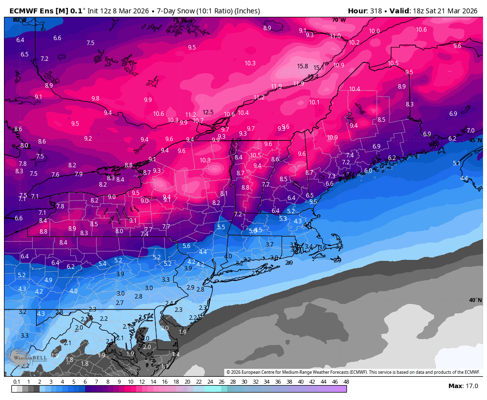
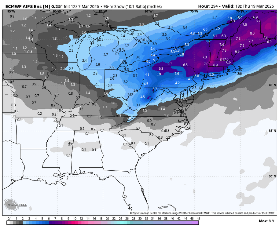
These would be healthy 7 day ensemble totals in mid Winter. So for mid March, this is a healthy signal.


-
Central PA Spring 2026 Discussion/Obs Thread
Blizzard of 93 replied to Voyager's topic in Upstate New York/Pennsylvania
It’s the ensembles that are talking about potential to shovel next week, across the board. These would be healthy 7 day totals in mid Winter. So for mid March, this is a healthy signal.
-
Central PA Spring 2026 Discussion/Obs Thread
Blizzard of 93 replied to Voyager's topic in Upstate New York/Pennsylvania
Lol, come on, I’m sure that I’ve nailed at least one call over the years…! -
Central PA Spring 2026 Discussion/Obs Thread
Blizzard of 93 replied to Voyager's topic in Upstate New York/Pennsylvania
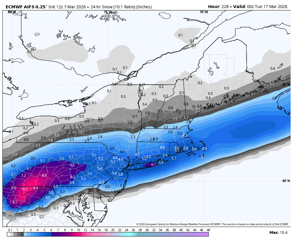
12z Euro snow for the 18th period.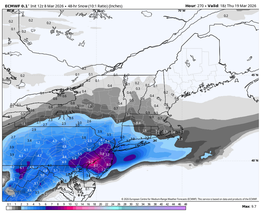
-
Central PA Spring 2026 Discussion/Obs Thread
Blizzard of 93 replied to Voyager's topic in Upstate New York/Pennsylvania
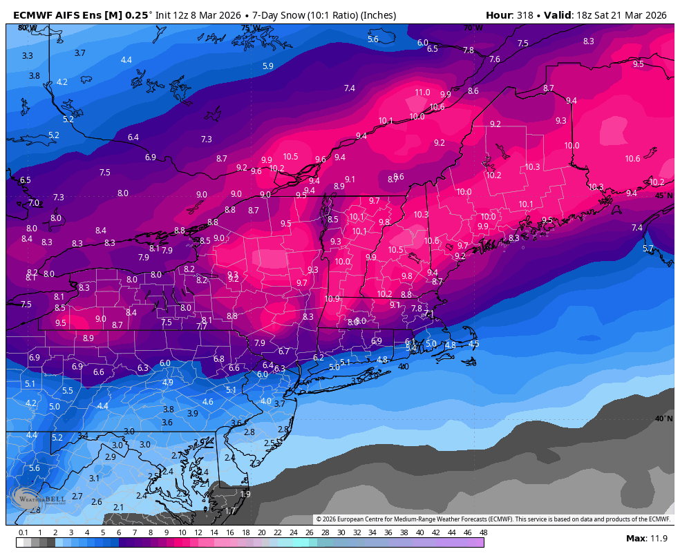
12z Euro is on board for a chance on the 18z as well. -
12z Euro snow for the 18th period.
-
12z Euro is on board for a chance on the 18z as well.
-
-
Central PA Spring 2026 Discussion/Obs Thread
Blizzard of 93 replied to Voyager's topic in Upstate New York/Pennsylvania
I’m talking next week, St. Patty’s Day time period. It’s too soon to pin down a specific threat, but we should have a chance or two with plenty of cold around. For example, the 12z Canadian shows how it could bring a snow chance next week. -
Central PA Spring 2026 Discussion/Obs Thread
Blizzard of 93 replied to Voyager's topic in Upstate New York/Pennsylvania
Get your snow shovel ready for next week… -
Central PA Spring 2026 Discussion/Obs Thread
Blizzard of 93 replied to Voyager's topic in Upstate New York/Pennsylvania
Hopefully nothing tragic like in Michigan & Oklahoma yesterday. -
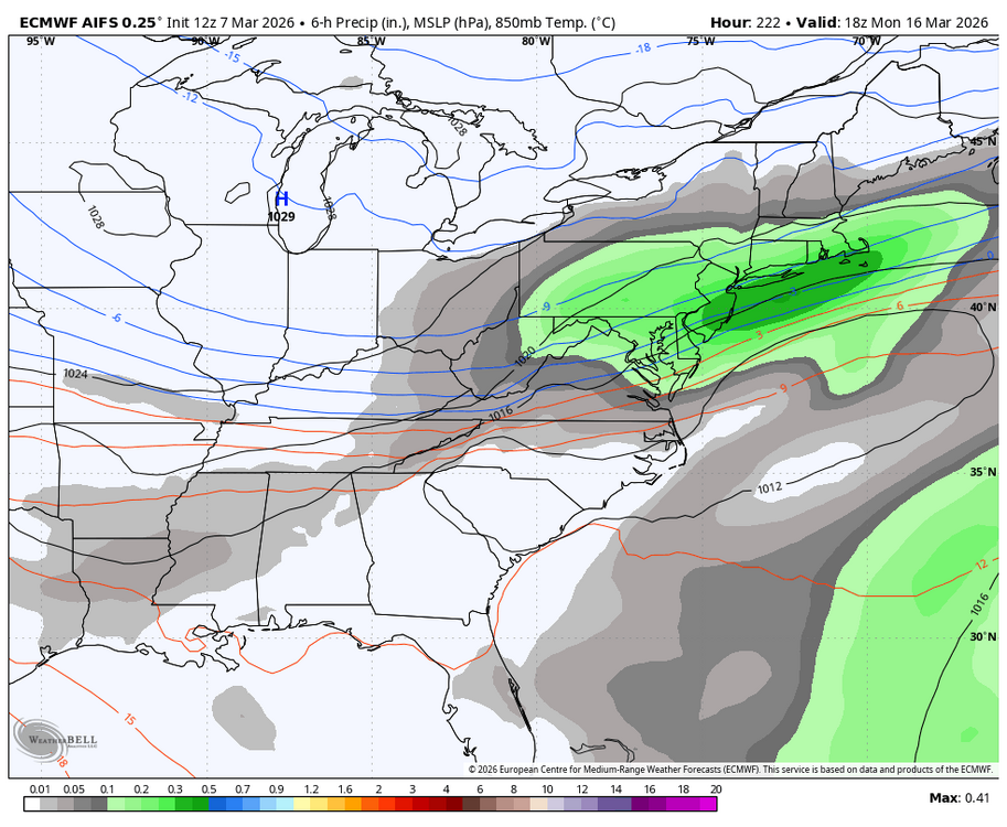
12z AI EPS for the period. The ingredients are there, we just need a specific chance or two to track in the window.

-
Central PA Spring 2026 Discussion/Obs Thread
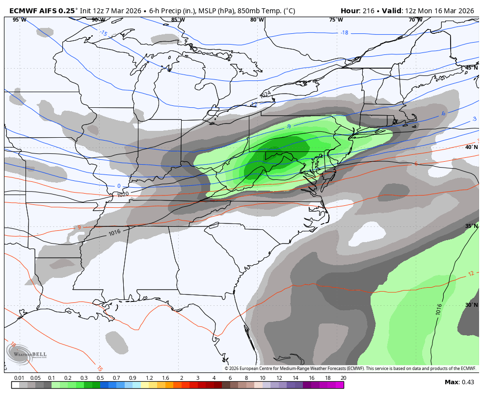
Blizzard of 93 replied to Voyager's topic in Upstate New York/Pennsylvania
Timing would be decent with a good chunk of the precip coming overnight through the morning.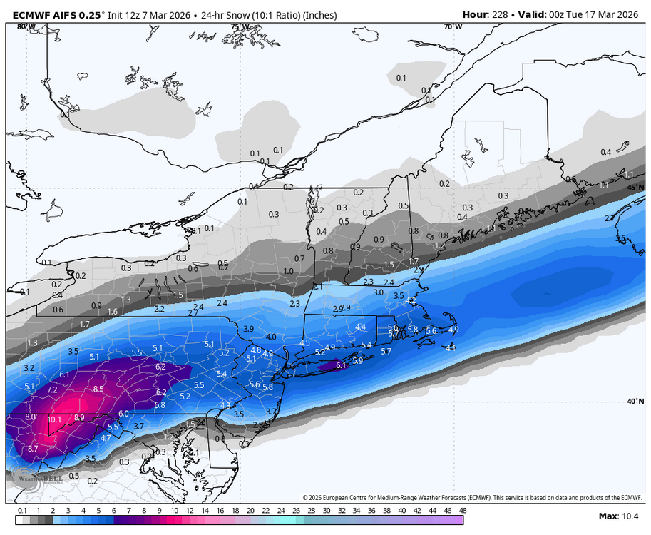

-
Central PA Spring 2026 Discussion/Obs Thread
Blizzard of 93 replied to Voyager's topic in Upstate New York/Pennsylvania
Yes, I would sign for the 12z AI. A nice & simple moderate wave with a good non complicated slug of precip this run.
-
Central PA Spring 2026 Discussion/Obs Thread
Blizzard of 93 replied to Voyager's topic in Upstate New York/Pennsylvania
Sorry to hear about your accident. Wave on your way through Marysville! Happy to hear that you & your wife are ok.