

Blizzard of 93
-
Posts
13,037 -
Joined
-
Last visited
Content Type
Profiles
Blogs
Forums
American Weather
Media Demo
Store
Gallery
Everything posted by Blizzard of 93
-
What’s your dew point now? I am at 19 & MDT is at 20 as of 11 pm I have been hovering near 20 most of the day.
-
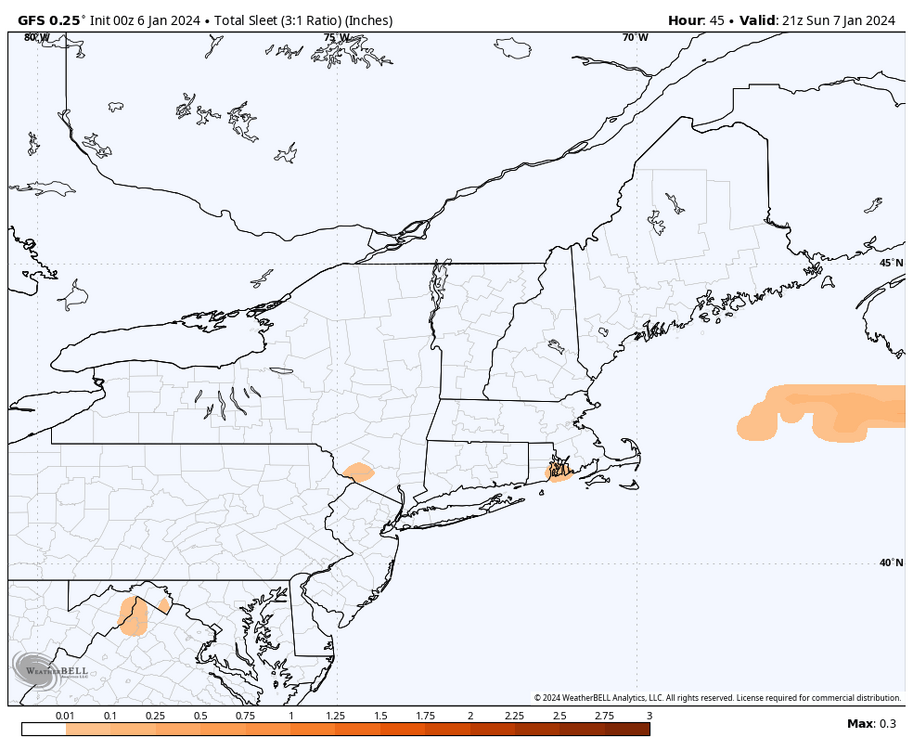
Here is the height of the storm on the GFS. It shows mixing in the LSV, but no plain rain in PA. The WB maps do split out Sleet & Freezing Rain separately, so they are Not lumped in with snow totals.
-
The 0z Canadian improved over its 12z run for Lancaster & still looks good for most of us
-
Who knows which service is better or more accurate? I pay my 27.99 per month to Weatherbell. They have a lot a commercial clients & 2 seasoned pro Mets that run the website. I don’t think they would be in business with bad maps…
-
0z GFS on Weatherbell looks very similar to 18z. Here they both are to compare.
-
0z GFS looks to be in line with most models this afternoon & evening.
-
23/19 in Marysville
-
0z ICON improved over the 18z run for the southern tier.
-
Good points, I think we are finally seeing convergence.
-
-
Another RGEM beauty of a run is underway.
-
Please, please, please
-
Welcome back!
-
Yes, the EPS…love it!
-
Just for fun…. Glass half full…you are 10 miles away from more as well…
-
18z Euro still decent for most.
-
We can’t forget the Happy Hour Herp a Derp short range Canadian! Looks good… I’ll take some Herp…lol
-
How much for Palmyra & Marysville?
-
Ohhhhh Canada….!
-
The RGEM has been very consistent & so has the ICON. Not sure how I feel about it, lol!
-
The 12z Euro is still the driest of the 3 globals at 12z. Hopefully it juices up some later on.
-
Nice improvement from the Euro over its 0z & 6z runs, especially for the southern tier counties.
-
Understood & all good too! I am guilty as charged for being too optimistic sometimes. Let’s enjoy whatever we end up with tomorrow.
-
35/21 in Marysville. Low dews should help tomorrow.
-
I am very experienced in the highs & lows on here & in my backyard in my nearly 30 years of tracking Winter storms. Lol, “funeral” might have been a little strong, but the southern tier crew were acting like it was over for all of us, that was my issue. I respect your experience & knowledge, & didn’t mean to insult you or anyone. I was just commenting on the tone of the thread for awhile this morning.


