

Orangeburgwx
-
Posts
2,592 -
Joined
-
Last visited
Content Type
Profiles
Blogs
Forums
American Weather
Media Demo
Store
Gallery
Posts posted by Orangeburgwx
-
-
GFS has it too but no cold airCanadian looks similar at that range so Euro is not alone..
Watch that shortwave diving in the 4 corners area around day 7/8.
Sent from my LGL322DL using Tapatalk
-
Funny enough everyone on the Southeast forum needs the opposite to happen. Still, everyone from northern Florida (Jacksonville ish) to New York needs to watch closei was thinking the same thing actually---it would slide out but its already giving us heavy now even from where its at. If it gained just a bit of latitude....
anyway...its 10 days out but its interesting
Sent from my LGL322DL using Tapatalk
-
Oh my lord... That will make A LOT of people on this forum happyCorrection: huge storm brewing
Sent from my LGL322DL using Tapatalk
-
12z


Sent from my LGL322DL using Tapatalk -
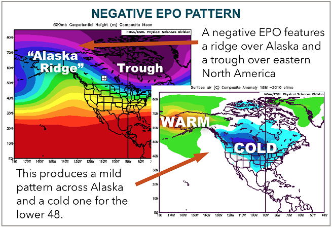
The fact we need a ridge over Alaska means it needs to be the orange and reds on the 500mb mapsHere is a weird question for everybody. When I look at the EPO index, it is clear the positive phase is the one that is correlated to cold in the Central/East. But then I see sites where the EPO in the negative phase is supposed to that. I know what the EPO is and what it does, but did CPC change the definition of which phase was positive? There seems to be a common split, where some people refer to the -EPO as "good" for cold in the East and others refer to +EPO as "good" for cold in the East, even they are clearly talking about the same thing, where one is named incorrectly.
This is Nov 2014, 2018, 2019 which all have major +EPO phases on the CPC index. But according to a site like the one below (not picking on them it just popped up), should be a -EPO. When people talk about a positive or negative EPO...are people even talking about the same thing? Phases seem to be defined oppositely in some places.
https://psl.noaa.gov/data/correlation/epo.data2014 1.11 0.31 1.24 0.05 0.77 -0.69 0.33 -1.03 0.20 -0.66 3.21 -99.902015 1.27 1.18 1.13 -0.35 0.49 1.72 0.23 -0.28 -1.38 0.33 -0.94 -99.902016 -0.35 0.23 0.24 1.47 0.14 1.26 -0.36 -0.42 -1.41 -0.84 -1.43 -99.902017 0.39 0.21 -1.04 1.04 -0.72 0.50 0.00 -1.65 -0.46 -0.58 0.41 -99.902018 0.66 0.23 0.30 -0.18 -0.98 0.05 -0.16 -0.78 -0.83 1.17 1.42 -99.902019 1.07 1.20 2.11 0.67 0.32 1.74 0.10 -1.18 -1.50 -0.47 1.93 -99.902020 -0.60 -1.79 0.44 1.54 0.04 -0.69 -1.97 -2.39 0.06 0.57 -0.66 -99.90
Sent from my LGL322DL using Tapatalk
-
I may be a weenie but I learned my lesson about Wishcasting the hard way...Man Orangeburg I’m a weenie but you might be the king. I would like to see a flake but ....
So I stick to posting model outputs
Sent from my LGL322DL using Tapatalk
-
 1
1
-
 1
1
-
-
True but it gives us outside the mountains hopeThe ull been there.
Just signs that the mountain folks will get hit hard
Sent from my LGL322DL using Tapatalk
-
It popped an ULL

Sent from my LGL322DL using Tapatalk -
HOLY SMOKES THE HRRR

Sent from my LGL322DL using Tapatalk-
2
-
-
12Z GEFS drops the hammer for most of us at least getting a dusting.


Sent from my LGL322DL using Tapatalk-
 1
1
-
 1
1
-
-
That $25/mo is worth it... Cause now I get the 6 and 18z ECMWFDon't tempt me!
Sent from my LGL322DL using Tapatalk
-
I have to thank you, because I am officially a WeatherBell subscriberCan't say why, but the evidence is that CoD only shows 20 ensemble members, whereas sites like WeatherBell shows the 30 from the FV3.
Sent from my LGL322DL using Tapatalk
-
1
-
-
Why doesn't CoD use the FV3?The GEFS maps from College of DuPage use the old GFS rather than the FV3. Meaning it could be more or less reliable depending on how you feel about the FV3 lol
I personally wouldn't put too much stock in this depiction. The "fingers" of snowfall seem to point to an issue resolving borderline temperatures during the time skips. Plus the pattern of snowfall would imply that this is the back end of the anafront, rather than post-front flurries from the back-end energy like the RGEM shows.
Sent from my LGL322DL using Tapatalk
-
0z GEFS suites... Get a load of ol' Love Potion #9


Sent from my LGL322DL using Tapatalk-
2
-
1
-
-
0z Mean

Sent from my LGL322DL using Tapatalk -
Follow up: so is the SREFHeck no, I been telling my family the GEFS has been drinking the EURO's spiced eggnog
Sent from my LGL322DL using Tapatalk
Sent from my LGL322DL using Tapatalk
-
Heck no, I been telling my family the GEFS has been drinking the EURO's spiced eggnogYou don't look at that and think its actually going to snow in Augusta over to Orangeburg do you?
Sent from my LGL322DL using Tapatalk
-
To me the absolutely insane thing is how 72 hours out the Euro is alone by itself, most of the other models ensembles show flakes but King Euro doesn't. Do we bet against it?
Sent from my LGL322DL using Tapatalk -
Here is 18zSo what's with the "banding" look to all of these members? 3-4 distinct ares of enhancement of anafrontal snowfall. Is it weak distinct disturbances riding up the front, or temp driven with time of day? Weird look.
Sent from my LGL322DL using Tapatalk
-
1
-
-
Ugh, accidentally sent the mean twice, here are the individual ensembles

Sent from my LGL322DL using Tapatalk-
1
-
-
Good lord


Sent from my LGL322DL using Tapatalk -
That's why we look at the ensemblesThe long range Euro looks crappy too
Sent from my LGL322DL using Tapatalk
-
Models going to have to play catch up to the oscillations, been awhile since they were this negative and have to adjust to itBeen a longtime since we have seen this kind of negative NAO in January. Even though GFS wasn't great today, still feel like timeframe after New Year's has potential.
https://www.cpc.ncep.noaa.gov/products/precip/CWlink/pna/nao_index_mrf.shtml
Sent from my LGL322DL using Tapatalk
-
It is the GFS, water is wetThe long range GFS continues to be a train wreck
Sent from my LGL322DL using Tapatalk
-
1
-
January Medium/Long Range Disco Thread
in Mid Atlantic
Posted
Goodness Tennessee...
Sent from my LGL322DL using Tapatalk