

Orangeburgwx
-
Posts
2,592 -
Joined
-
Last visited
Content Type
Profiles
Blogs
Forums
American Weather
Media Demo
Store
Gallery
Posts posted by Orangeburgwx
-
-
Unflagged 98kt surface wind in the SE eyewall
Sent from my LML212VL using Tapatalk -
This is gonna be a memefrst isnt it...Okay I'll start.
The windspeeds are gong to have a pretty big Delta
Going through the eyewall was like going through a Delta function.
I'm onboard for the ride
Sent from my LML212VL using Tapatalk
-
NHC is gonna have to pull the trigger at 11...
Cat 3
Sent from my LML212VL using Tapatalk -
Extrap 957
Sent from my LML212VL using Tapatalk -
Ring of DeathSo, who's gonna say it first?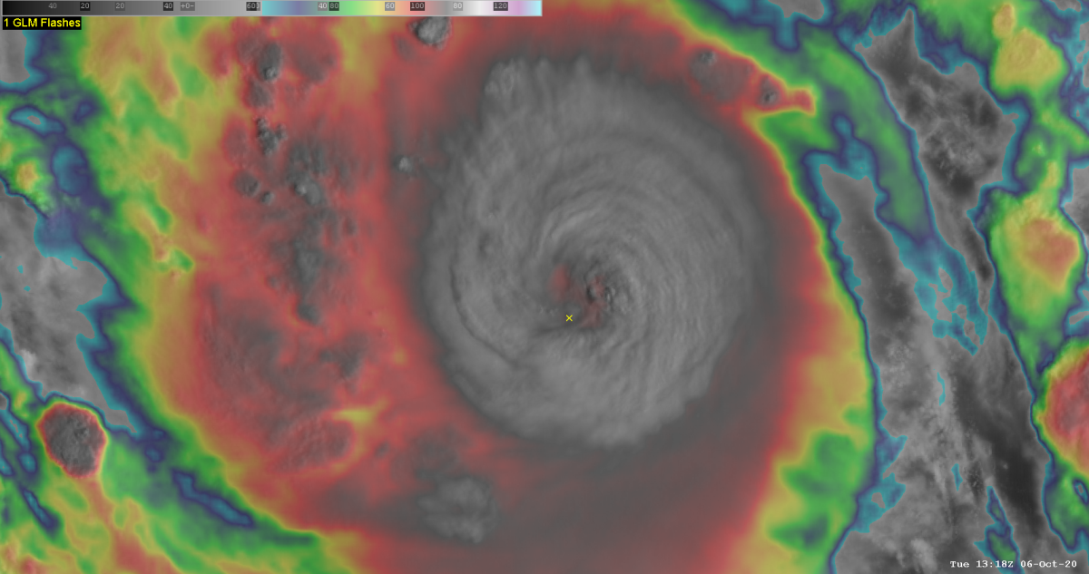
Sent from my LML212VL using Tapatalk
-
There it is

Sent from my LML212VL using Tapatalk -
0z peaks at Cat 4 120kts, but 18z was pure crack cocaine...

Sent from my LML212VL using Tapatalk -
Radar out of Cancun, look at the last image

Sent from my LML212VL using Tapatalk-
 2
2
-
-
What were the odds Greece got ****ed by a MediStorm on the same day we go Greek in the Atlantic?
Sent from my LML212VL using Tapatalk-
1
-
 5
5
-
-
Texas going to be Beta testedWell this feels like a bit of a rip-off...really wanted Alpha for the gulf...
Sent from my LML212VL using Tapatalk
-
2
-
2
-
-
That sounds like a rave to be fair...
Sent from my LML212VL using Tapatalk
-
Joey Logano's 22 failed post race inspection, 98L is the winnerProbably won on a technicality since 22's recon had to bail.
Sent from my LML212VL using Tapatalk
-
1
-
3
-
-
It beat 22, we have Wilfred

Sent from my LML212VL using Tapatalk-
 1
1
-
-
Wtf you doing 22

Sent from my LML212VL using Tapatalk -
2020 kinda burned the rules...No we haven’t. A season can’t be epic without a sub 915 storm. It’s a rule.
Sent from my LML212VL using Tapatalk
-
2
-
-
-Merger EWRC: LauraWell I don’t think anyone can complain about this hurricane season, 2020 has literally had something for everyone. If you’re a numbers person, we’re going on the “w” storm halfway through September. You like high end hurricane landfalls? Laura. You like disorganized spinny thingies with names? You’ll be set for 3 years. East coast metro hit? Isaias produced hurricane force gusts from N.C. to MA. Long track MDR storms? Paulette and Teddy. High end fish storm, watch teddy this week. Hurricane landfalls? Every single hurricane has hit land. Teddy may too. Rapid Intensification? Check. Survivalist storms? We’ve had two hit the tallest peaks in the Caribbean and STRENGTHEN after doing so. You a person who loves strengthening systems on approach? Check check check check check check. Preseason named storm? Yep. Needle in a haystack storm? Paulette making landfall on Bermuda. Slow moving epic rain producer? Sally. Ridiculous storm surge, thank you Laura. I mean, we’ve had everything for everyone!-"Moisture Bubble" storms that gave the middle finger to dry air and shear? Everything near the Lesser A.
-"Border crosser": Hanna
-Sub 940mb GoM? Laura
-Bahamas strike: Isaias
Central America strike: Nana
-South Carolina landfall: Bertha
-Laura and Sally knocked out radar towers
-Sally pulled a Harvey with rainfall totals
-17/20 storms have set the earliest date (Arthur, Bertha, and Dolly did not)
So yeah, something for everybody except the people who believe ACE should be the only standard (which it should be done away with IMO)
Sent from my LML212VL using Tapatalk
-
Consistency can be a bad thing at timesI complained about those too. It’s called being consistent.
Sent from my LML212VL using Tapatalk
-
Ridges are overdone on the ECMWF that far out, so good chance that one over the virgin islands misses the GA to the north. So that will be Paulette going extratropical, Tammy, Vicky, and Wilfred (if 94L gets named, aka Sally -not shown there-) which means whatever forms after that will be Greek0z Euro
Sent from my LML212VL using Tapatalk
-
You left off our very own AmericanWx member "Hurricane Man" Josh...I'm going to base mine on the three I am more familiar with. Anyone who is not on this list are just clicks to me for my viewing pleasure when they have the best seats in the house during a storm. Faces that I don't and won't remember. Being forgettable isn't always a bad thing though.
1) Brett Adair - Love the guy, and can't say a negative thing about him. By far my favorite "Known" chaser. He gives me down to earth vibes and someone I wouldn't feel intimidated to be around.
2 Reed Timmer - He's a odd one for me. I used to absolutely hate him, but he has been growing on me the last few years. I think him getting older is making him more mature nowadays. His lack of maturity was always my main issue with him. Will I grow into following him on the regular? Absolutely not. He is too "Mainstream" and has a celebrity aura attached to him. That is not necessarily a bad thing, it is just something I'm not personally into. With all that said, I see growth happening with him and I appreciate that. A side not for Reed if you read this... sack that annoying guy that was in the vehicle with you during the Laura stream. You know, the one that couldn't say a sentence without stuffing 6 cuss words in it. He is going to get you and your stream in trouble and plus it is a sign of someone without intelligence. Your viewers will thank you for it.
3 Jeff Piotrowski - Here is where I'm going to get a little mean. Before I say anything else, I will say that I used to really enjoy him. Sometime after the Joplin tornado he started to gradually get worse for me. His Laura stream sealed the deal on me ever watching him again. It was a definition of a disaster stream if I ever seen one. Jeff has major ego issues and think his sh*t don't stink. I lost count on how many times he was bragging about viewership numbers like one of those instagram ho's. During a pivotal moment of the storm, and as he was showing us viewers how awesome a wall looked and missing majority of the action inside the parking garage, he kept screeching how media was going to pay him for his video if they wanted it. I have no problem if someone wants to get paid for their work, it just could have been handled more professionally. Those of you who watched his stream know EXACTLY the moment that I am talking about. It was a yikes moment if I ever seen one. Come off that high horse Jeff, your video was nothing worthy of being bought. Every single other chaser had a better stream of Laura than you, including the lesser known chasers. Also, he was screeching and getting mad about people calling him during a portion of his stream that I almost threw my headphones across the room from all the yelling. Does he know there is a button to turn off the volume on a smartphone?<_ thing that annoyed me he was falsely stating wind speeds of the hurricane numerous times. stated backside had mph winds coming in when other verified sources posted what actual were into lake charles on backside. is as bad those mets give ef ratings to tornadoes while they are hitting. jeff needs cut his crazy theatrics. instead a chaser comes across helpless civilian caught nature fury. dude eat some humble pie.>
Sent from my LML212VL using Tapatalk
-
So it will be a Nana-cane in post analysisNana was upgraded when a burst of convection fired over the center, but now the convection has been sheared back south. Recon just made a final pass and found the pressure up and the wind down.
Sent from my LML212VL using Tapatalk
-
Wait he said whatWouldn't be a hurricane season without cranky's incredibly bad hurricane takes. Remember, Michael was only a cat 1 at landfall
Sent from my LML212VL using Tapatalk
-
I can only image the met writing that with a Chesire grin on his faceNice near term disco by MOB for my area this morning!NEAR TERM UPDATE /Now Through Tuesday/...As of this morning, theTropical Storm Watch was cancelled for Mobile and BaldwinCounties in Alabama as well as George and Stone counties insoutheast Mississippi. However, windy conditions will be possibletoday. Thus, a Wind Advisory was issued through 7PM CDT thisevening for coastal Mobile and coastal Baldwin counties (mainlyalong the immediate coast) for easterly winds 15-25 mph with gustsup to 35 mph. /26The main point is that the next 48 hours or so will be ratherwet. Marco is currently in a world of absolute hurt as 30 knots ofsouthwesterly shear from the upper trough over the ARKLATEXregion has begun to decouple the low level circulation from themid-level circulation. However as long as there is deep convectionassociated with the mid-level circulation, the low-levelcirculation will continue to attempt to move with the mid-levelcirculation causing the track to potentially shift a little moreeast than originally expected and the NHC`s latest track reflectsthat (about 20 mile eastward shift given the storms position).This really won`t have much of an impact on us as the shear willonly increase with time and the low-levels will eventuallydecouple causing the low-level center to track westward and themid-level center to continue moving north towards our area.Imagine the head of the storm going one way and the legs going theopposite direction. Since the mid-level circulation is expectedto move across the area, a plume of 2 to 2.5 inches PWATs willoverspread the area tonight into Monday. Typically with thesehighly sheared systems most of the rainfall ends up being well tothe east from the actual center and in this situation thats us.Scattered to numerous storms will be expected as lift associatedwith that Mid-level center increases over the area beginning alongthe coast later tonight then slowly spreading inland throughoutthe day. So all in all rain chances will continue to stay high atleast through Monday night and likely into Tuesday especially oversouthwestern Alabama and southeastern Mississippi.The main threat with these storms will be locally heavy rainfallgiven PWATS of 2.5 leading to likely efficient warm rain processesand rainfall rates likely approaching 2 to 3 inches per hour inthe heaviest bands. Locally heavy rainfall of 3 to 6 inches willbe possible along the coast with some locations getting locallyhigher amounts. For instance areas in Tallahassee`s area saw inexcess of 7 inches today where a band setup for a couple of hours.These higher amounts will be based on where any banding sets up.Due to this, the flash flood watch will continue for coastalAlabama, southeast Mississippi, and far western Florida Panhandle.Along with the rain threat, an isolated tornado threat will bepossible, given we are on the eastern side which typicallysupports the higher tornado threat. Luckily we will be removedfrom the low-level center and the better backed surface winds willbe displaced to our west. I cannot rule out a tornado or two,especially during the late afternoon hours tomorrow into earlytomorrow night. Winds will be gusty as well as storms mix downhigher winds associated with the mid-level center. Some showerscould have gusts to 30 to 40 mph.Luckily with all the rain, temperatures will be on the light sideand will struggle to reach the low 80s. Lows will remain highthough given the increased low level moisture throughout theperiod. Rip current risk will remain HIGH for quite some time andwe had reports of 26 beach rescues yesterday at Pensacola beachalone. The water is not safe and a high surf advisory will alsocontinue through the period. BB/03
Sent from my LML212VL using Tapatalk
-
1
-
-
No, but the NAM is laughableAnyone see the ICON makes Laura 225 mph at landfall?
Sent from my LML212VL using Tapatalk
-
I think we all busted for the amount of majors
Sent from my LML212VL using Tapatalk

Major Hurricane Delta
in Tropical Headquarters
Posted
Sent from my LML212VL using Tapatalk