

Orangeburgwx
-
Posts
2,592 -
Joined
-
Last visited
Content Type
Profiles
Blogs
Forums
American Weather
Media Demo
Store
Gallery
Posts posted by Orangeburgwx
-
-
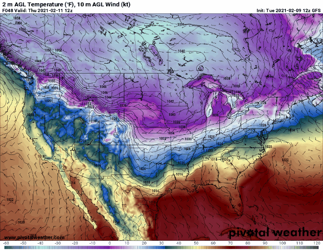
12z GEFS is out to lunch... Way warmer than OP (Weatherbell pic)


Sent from my LGL322DL using Tapatalk -
Anyone else get this when they try to pull up the GEFS on Weatherbell?

Sent from my LGL322DL using Tapatalk -
2018 redux but ice instead of snow


Sent from my LGL322DL using Tapatalk -
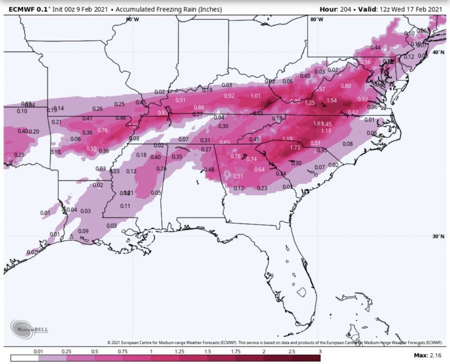
Question is, how far south the wedge will go...Something to remember, this CAD has a direct connection to the parent HP over Canada. Once we start getting the northeasterly wind feed setup later this week, I have a hard time seeing the wedge breaking until the HP moves out of position offshore, which wont' happen until next week. It's honestly going to only get stronger over as time goes on and the HP buildings into the Dakotas and eventually slides east.
So we could be looking at several days of freezing rain/sleet coinciding with the STJ impulses that are coming through. The models will likely trend towards this solution over time.
Sent from my LGL322DL using Tapatalk
-
Going by the ICON, a lotSerious question: What are the chances that a lot of Valentine’s deliveries will be messed up for Saturday? My wife pulled the old “oh, don’t bother getting me anything” trick, but I’m not falling for that one. LOL
Sent from my LGL322DL using Tapatalk
-
NC only?It looks like the NAM is showing a multi-day ice event.
Sent from my LGL322DL using Tapatalk
-
6z ENS came in way warmer (this is in Celsius)


Sent from my LGL322DL using Tapatalk -
Diamond City Radio was the best part of Fallout76 and I will die on that hillI have the sudden urge to play me some Fallout.
Sent from my LGL322DL using Tapatalk
-
I rather have lights and rain at 33 than in the dark for 2 weeksGuess it just depends on which you enjoy most, extreme weather or having your lights on.
Sent from my LGL322DL using Tapatalk
-
 2
2
-
-
 Southeast winter
Its done got me down
Southeast winter
There is no cold air around!
Pack up the truck, pick up my stake
Imma movin' to a northern state
Southeast winter
Its done got me down!
(Yes I just parodied "Uranium Fever", no, I am not sorry XD)
Sent from my LGL322DL using Tapatalk-
 3
3
-
-
Underestimated what, the warm nose?I feel like this season they have underestimated so far... at least for the 2 CAD icing events we've had.
Sent from my LGL322DL using Tapatalk
-
To be fair, so are the modelsOh yeah. It’s just people in the mid-long thread seem to change their minds about what’s gonna happen every five minutes. Lol.
Sent from my LGL322DL using Tapatalk
-
1
-
-
.3" of ice, unfortunately, my mom's full blooded Chow Chow was outside the day before it hit (temps were in the 50s so we thought we were in the clear, but changed over faster than had been forecasted) and went into labor in the middle of the night...I got lucky in ‘14 and got more sleet than ice when I was living in Columbia. Sledding was off the charts for almost a week. It was worth the scrapes I got as I hit sound barrier speed going down our favorite hill. From Augusta to the SC coast wasn’t as lucky. One of the worst ice storms I’ve seen in the 30 something years here in SC.
Lost 8 out of 13 puppies, and the ground was frozen like a brick from SL/ZR (and got a dusting of snow on top) while having to dig those graves... That day royally sucked
Sent from my LGL322DL using Tapatalk
-
You ok Bloo?I don’t know what’s happening anymore.
Sent from my LGL322DL using Tapatalk
-
1
-
-
Sent from my LGL322DL using Tapatalk
-
Not to mention the number 1 rule of winterThis could end up being a multi-day ice on ice event for some. Very little melting going on. Tenths upon tenths of zr. This long duration event would easily rival the tree damage I experienced back in 2002. Pray for sleet but go ahead and buy your gennie now if you ever wanted one. This is U..G..L..Y!
Models ALWAYS underestimate CAD and overdo WAA, I think even SC is going to hit the ice city bingo like the 0Z Euro showed
Sent from my LGL322DL using Tapatalk
-
ENS running now fyi
Sent from my LGL322DL using Tapatalk -
If it stats tilted positive would all the ice flip to snow?Near ‘perfect’ freezing rain setup as the southern wave and retreating TPV in SE Canada were closer together so the high was in ‘perfect’ damming location during the storm with strong cold source. Also, southern wave goes negative tilt and tracks to our northwest so the mid levels warm
Sent from my LGL322DL using Tapatalk
-
Holy shit...nearly got the entirety of the tristate area
Sent from my LGL322DL using Tapatalk
-
Anytime you mention my town it better be rain, sleet, or snow, 05 still haunts me man... 2 weeks with no power infused me with an intense hatred and fear of a mega ice stormBig CAD setup on Euro Mon night into Tues. Ice down to Macon and Orangeburg. Retreats north but upstate stays below freezing full storm
Sent from my LGL322DL using Tapatalk
-
1
-
-
Yesh

Sent from my LGL322DL using Tapatalk -
As a Gamecock fan... No offense takenWelp. I’ll take South Carolina football fans’ approach to every season: there’s always next year
Sent from my LGL322DL using Tapatalk
-
What the hell?!Wedge induced Freezing rain all way in to Florida on the icon, never seen that before
Sent from my LGL322DL using Tapatalk
-
GEFS too warm, doesn't punch the cold until Tuesday

Sent from my LGL322DL using Tapatalk-
 1
1
-

Mid to Long Term Discussion 2021
in Southeastern States
Posted
Sent from my LGL322DL using Tapatalk