LakeEffectKing
-
Posts
4,476 -
Joined
-
Last visited
Content Type
Profiles
Blogs
Forums
American Weather
Media Demo
Store
Gallery
Everything posted by LakeEffectKing
-

Upstate/Eastern New York
LakeEffectKing replied to BuffaloWeather's topic in Upstate New York/Pennsylvania
Lots of mix/IP/rain OBs in NJ/E PA....hmmmm...
-
Upstate/Eastern New York
LakeEffectKing replied to BuffaloWeather's topic in Upstate New York/Pennsylvania
The fact the models are struggling already With QPF up here, suggests to me that Most if not all the models are struggling with the moisture fields at the low and mid levels... So I guess I would lean towards this being an over performer With regards to most of the model QPF outputs. -
Upstate/Eastern New York
LakeEffectKing replied to BuffaloWeather's topic in Upstate New York/Pennsylvania
What is fascinating is that none of the model runs at 06z have anything that is close to verification on the northern edge of this system....up to 2/3's of an inch here.... Ratios will be our friend!! -
Upstate/Eastern New York
LakeEffectKing replied to BuffaloWeather's topic in Upstate New York/Pennsylvania
Winter Storm Warning URGENT - WINTER WEATHER MESSAGE National Weather Service Binghamton NY 416 AM EST Mon Feb 1 2021 NYZ015>018-023-025-044-020930- /O.UPG.KBGM.WS.A.0002.210201T1500Z-210203T0000Z/ /O.EXB.KBGM.WS.W.0004.210201T1500Z-210203T1000Z/ Yates-Seneca-Southern Cayuga-Onondaga-Schuyler-Tompkins-Cortland- Including the cities of Penn Yan, Seneca Falls, Auburn, Syracuse, Watkins Glen, Ithaca, and Cortland 416 AM EST Mon Feb 1 2021 ...WINTER STORM WARNING IN EFFECT FROM 10 AM THIS MORNING TO 5 AM EST WEDNESDAY... * WHAT...Heavy snow expected. Total snow accumulations of 8 to 12 inches with locally higher amounts. * WHERE...Yates, Seneca, Southern Cayuga, Onondaga, Schuyler, Tompkins and Cortland counties. * WHEN...From 10 AM this morning to 5 AM EST Wednesday. * IMPACTS...Travel could be very difficult. The hazardous conditions could impact the morning and evening commutes today. * ADDITIONAL DETAILS...This will be a long duration event. Occasional light snow falls today but then snow may become heavy at times late today through Tuesday with areas of blowing snow. Snow showers and Lake Effect continue through Tuesday night with additional snow accumulations. PRECAUTIONARY/PREPAREDNESS ACTIONS... If you must travel, keep an extra flashlight, food, and water in your vehicle in case of an emergency. The latest road conditions for the state you are calling from can be obtained by calling 5 1 1. && $$ -
Upstate/Eastern New York
LakeEffectKing replied to BuffaloWeather's topic in Upstate New York/Pennsylvania
No model had me even close to qpf att....had my area starting to snow at 06-07 z TOMORROW! Snow SHOULD retract to the SW with my area and points just north...ie a lull...but HRRR 07 has the snow now pivoting back by 00z. I think the key to this forecast now Is a feature that is exiting off the Georgia coast now... Canadian models (and now HRRR) are picking up on it and actually have a LP go into Cape Cod. Fascinating system!!! -
Upstate/Eastern New York
LakeEffectKing replied to BuffaloWeather's topic in Upstate New York/Pennsylvania
Snowing lightly in Cazenovia...1/4". -
Upstate/Eastern New York
LakeEffectKing replied to BuffaloWeather's topic in Upstate New York/Pennsylvania
Kuchies?? -
Upstate/Eastern New York
LakeEffectKing replied to BuffaloWeather's topic in Upstate New York/Pennsylvania
F-that...grab your gummies and enjoy all surprises upcoming! -
Upstate/Eastern New York
LakeEffectKing replied to BuffaloWeather's topic in Upstate New York/Pennsylvania
Nam running...most important run of our lives!! -
Upstate/Eastern New York
LakeEffectKing replied to BuffaloWeather's topic in Upstate New York/Pennsylvania
And crazy uncle..at least for cny. -
Upstate/Eastern New York
LakeEffectKing replied to BuffaloWeather's topic in Upstate New York/Pennsylvania
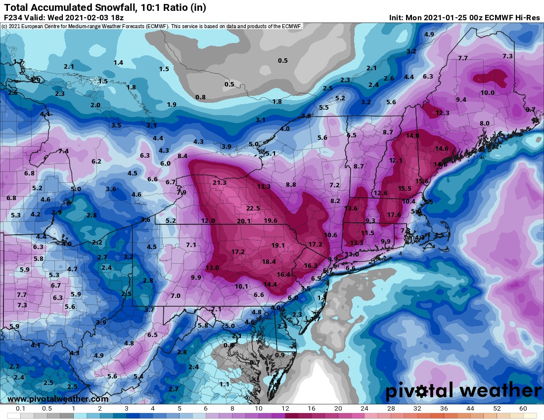
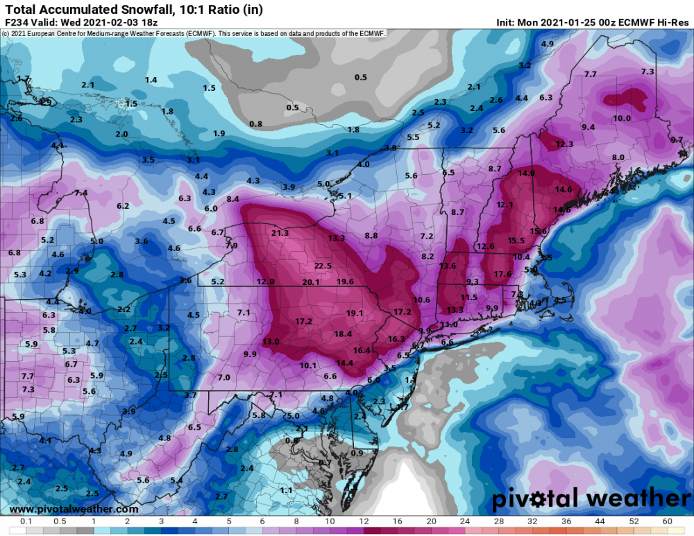
IMBY post..... love seeing Western Madison County in a snow maximum on pretty much all the models now. That said, I think this has room for improvement for all of central and Western New York. -
Upstate/Eastern New York
LakeEffectKing replied to BuffaloWeather's topic in Upstate New York/Pennsylvania
And that 55ft. covers a very small area. Ave. Is about 20-25'. That said, you can get enhancement from any frozen ( especially, long/narrow) bodies of water just through frictional convergence mechanisms...but obviously, open water adds moisture along with the convergence. In early season cold snaps, Sylvan/Verona Beachs and points east can certainly be enhanced by Oneida Lake. -
Upstate/Eastern New York
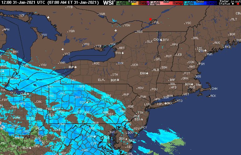
LakeEffectKing replied to BuffaloWeather's topic in Upstate New York/Pennsylvania
All models missing northern extent of precip vs. radar: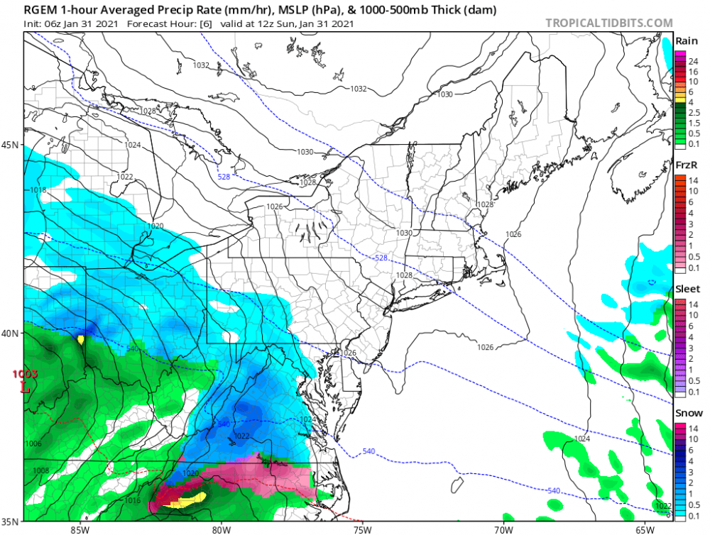
-
Upstate/Eastern New York
LakeEffectKing replied to BuffaloWeather's topic in Upstate New York/Pennsylvania
Great. Thanks! -
Upstate/Eastern New York
LakeEffectKing replied to BuffaloWeather's topic in Upstate New York/Pennsylvania
Do you have the hr. 114 or 120 map? -
Upstate/Eastern New York
LakeEffectKing replied to BuffaloWeather's topic in Upstate New York/Pennsylvania
6" of fluff overnight...still parachuting... If these ratios keep up overnight into tomorrow then there will be some major busts with forecasts' that are relying upon a 25:1ratio. -
Upstate/Eastern New York
LakeEffectKing replied to BuffaloWeather's topic in Upstate New York/Pennsylvania
My all time favorite!!! -
Upstate/Eastern New York
LakeEffectKing replied to BuffaloWeather's topic in Upstate New York/Pennsylvania
Next time a system comes into WPA/WNY, where there isn't any strong support for coastal redevelopment, remember this system...models just don't do well with this scenario, for whatever reason... ...perhaps a research project could tease out the reason(s), and help future modeling. -
Upstate/Eastern New York
LakeEffectKing replied to BuffaloWeather's topic in Upstate New York/Pennsylvania
Mixing with IP now in Bridgeport. -
Upstate/Eastern New York
LakeEffectKing replied to BuffaloWeather's topic in Upstate New York/Pennsylvania
It's all about the systems that make it into Western Pennsylvania or Western New York. I've seen it time and time again Where the modles underplay the Dry slot/warming level, right up to T+0. -
Upstate/Eastern New York
LakeEffectKing replied to BuffaloWeather's topic in Upstate New York/Pennsylvania
Ripping in Bridgeport.
-
Upstate/Eastern New York
LakeEffectKing replied to BuffaloWeather's topic in Upstate New York/Pennsylvania
Lol...ok! -
Upstate/Eastern New York
LakeEffectKing replied to BuffaloWeather's topic in Upstate New York/Pennsylvania
-
Upstate/Eastern New York
LakeEffectKing replied to BuffaloWeather's topic in Upstate New York/Pennsylvania
Still my thinking... I think the fingerlakes region and South are a good bet to dry slot and taint. Max snow totals will probably be E. LO region into the S. Adirondack. This has been my thinking since model consensus was showing max snow near the PA/NY border. Models will play catch up until T+0... -
Upstate/Eastern New York
LakeEffectKing replied to BuffaloWeather's topic in Upstate New York/Pennsylvania