LakeEffectKing
-
Posts
4,476 -
Joined
-
Last visited
Content Type
Profiles
Blogs
Forums
American Weather
Media Demo
Store
Gallery
Everything posted by LakeEffectKing
-

Upstate/Eastern New York
LakeEffectKing replied to BuffaloWeather's topic in Upstate New York/Pennsylvania
Yeah...put me down for putrid, when describing the NWS radar.... Guess I'll stick with College of DuPage's radar... -
Upstate/Eastern New York
LakeEffectKing replied to BuffaloWeather's topic in Upstate New York/Pennsylvania
9.5 days
-
Upstate/Eastern New York
LakeEffectKing replied to BuffaloWeather's topic in Upstate New York/Pennsylvania
Thicknesses shrink about 2.5 miles (400dam) in 18 hrs....Serious cold advection!!! -
Upstate/Eastern New York
LakeEffectKing replied to BuffaloWeather's topic in Upstate New York/Pennsylvania
Looks like gfs forms a wave along the front and provides a bit of goods for most of our area.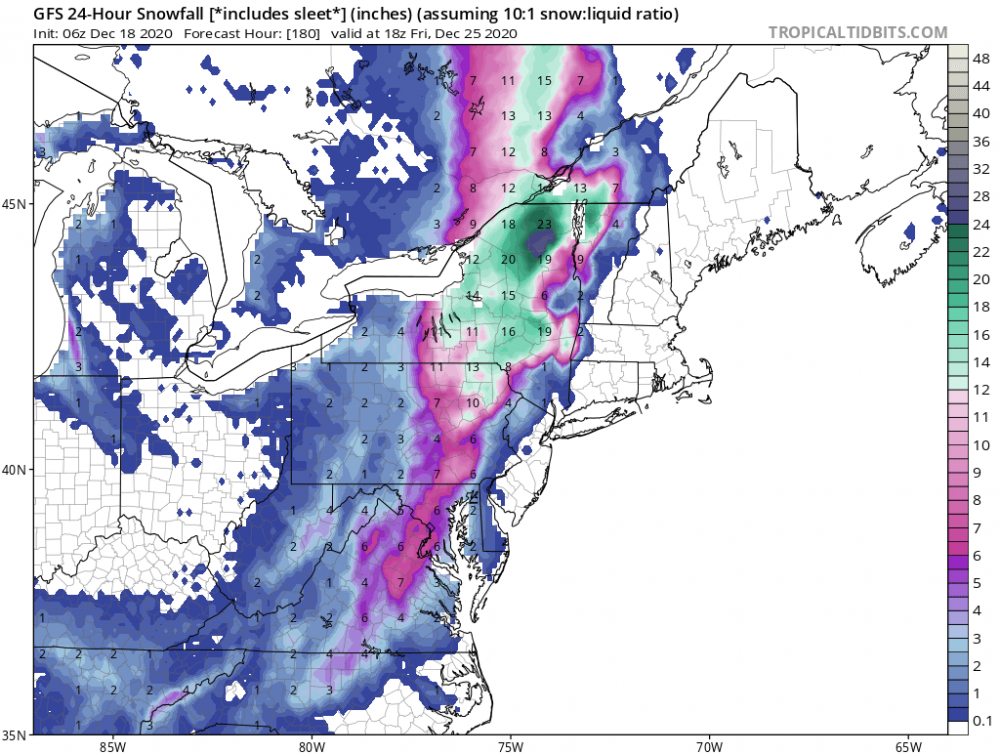
-
Dec 16-17 Storm OBS Thread
LakeEffectKing replied to BuffaloWeather's topic in Upstate New York/Pennsylvania
Para did pretty well, if you check more than one run. -
Upstate/Eastern New York
LakeEffectKing replied to BuffaloWeather's topic in Upstate New York/Pennsylvania
Glancing over all the gfsv16 model runs prior to the storm, It certainly seemed to handle the system much better than the current GFS version. -
Dec 16-17 Storm OBS Thread
LakeEffectKing replied to BuffaloWeather's topic in Upstate New York/Pennsylvania
Wrapping up here in Cazenovia...8.5" OTG....Just shy of 10" for storm. -
Dec 16-17 Storm OBS Thread
LakeEffectKing replied to BuffaloWeather's topic in Upstate New York/Pennsylvania
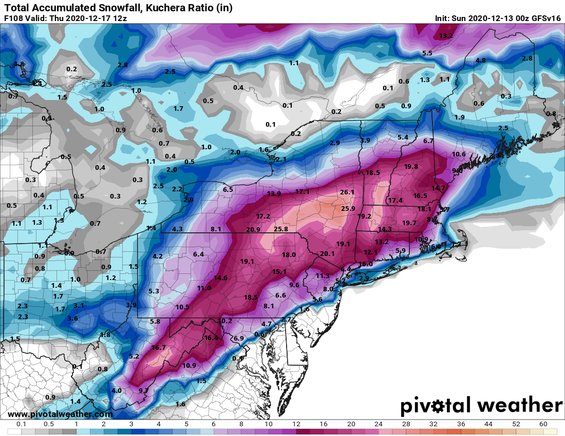
Kutchra maps underperformed there......just sayin'! -
Dec 16-17 Storm OBS Thread
LakeEffectKing replied to BuffaloWeather's topic in Upstate New York/Pennsylvania
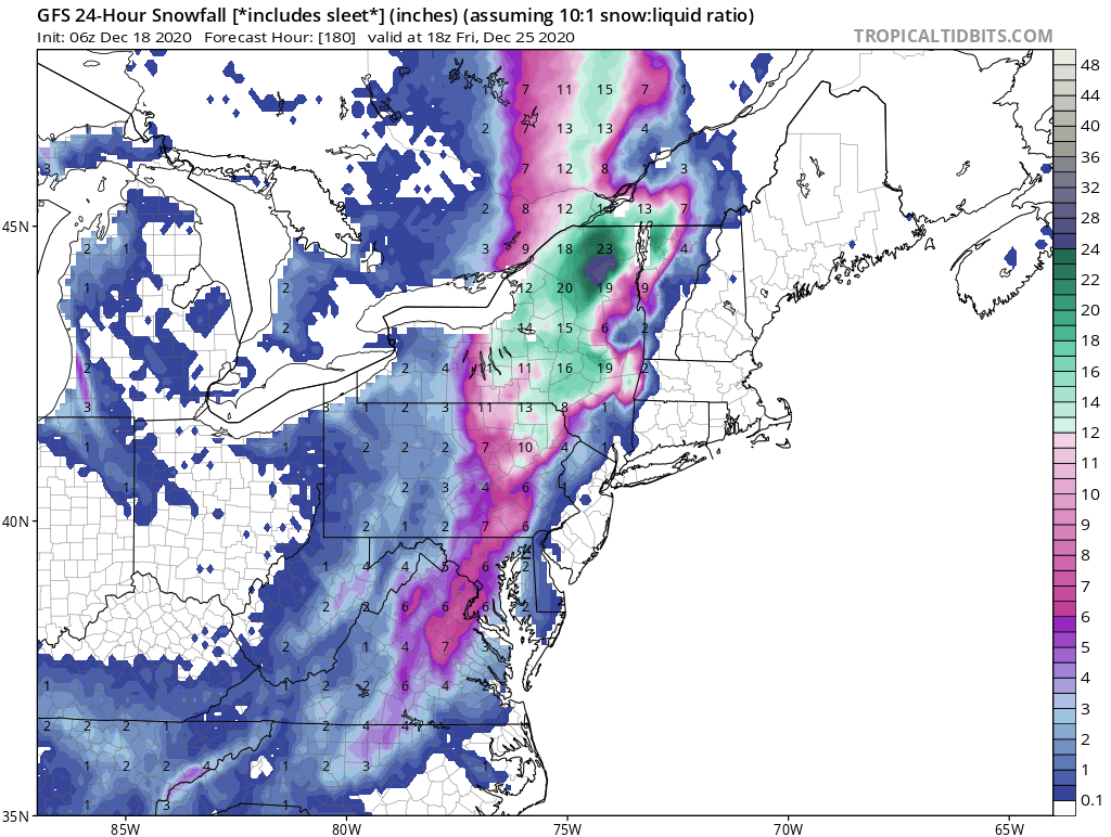
Just remember into the future....Pretty much all the models do not handle the placement of mesoscale banding features very well. Usually, (but not all the time), placement seems 30-50 miles to the NW vs. model consensus...even at lead times of 12 hours!!! Miller B's are complicated buggers. -
Dec 16-17 Storm OBS Thread
LakeEffectKing replied to BuffaloWeather's topic in Upstate New York/Pennsylvania
Enjoy my friend!! -
Dec 16-17 Storm OBS Thread
LakeEffectKing replied to BuffaloWeather's topic in Upstate New York/Pennsylvania
For posterity: From BGM 12/17/2020 06z 1 am update... Update to add Madison and southern Oneida in the winter storm warning. Radar and the models show a band of very heavy snow from Bradford County PA to Otsego County NY. The band is expected to slowly pivot into southern Oneida and Madison Counties between 3 and 6 AM before weakening. Upped snow amounts under the band from the twin tiers into the upper Susquehanna Region of NY. Reported snowfall rates as high as 3 to 5 inches an hour. Totals now in the southern tier double digits. -
Dec 16-17 Storm OBS Thread
LakeEffectKing replied to BuffaloWeather's topic in Upstate New York/Pennsylvania
GFS parallel handled this pretty well on Sunday!!! And were close to my thoughts then. A little overdone on the northern fringes. Post from Sunday on other thread: Hey all. IMO, as has been discussed a bit earlier and needs to be emphasized, for much of Upstate NY, the exact track of the slp is less important than the evolution of the mid and upper level features, particularly at the h850 and h700 levels. The models currently indicating a more favorable set up with these features for our area is euro ensemble mean, Icon, para GFS, and probably extrapolated NAM. I like where we are right now, particularly BGM, SYR and points SE. 00z Parallel GFS "feels" like a nice candidate for verification.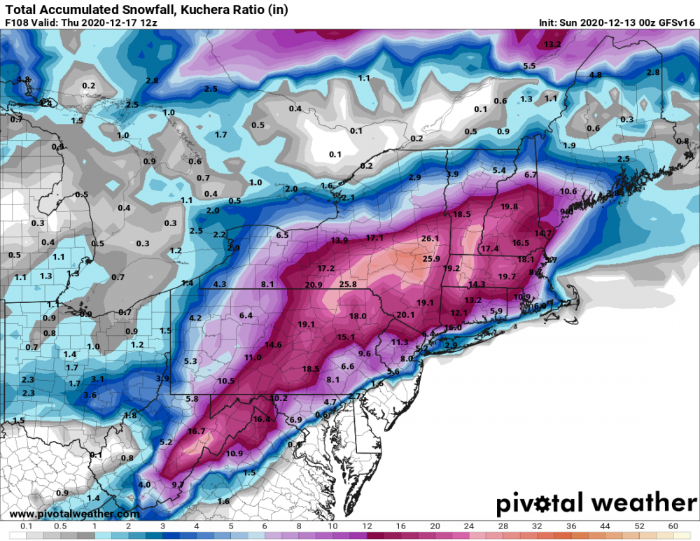
-
Upstate/Eastern New York
LakeEffectKing replied to BuffaloWeather's topic in Upstate New York/Pennsylvania
GFS parallel handled this pretty well on Sunday!!! And were close to my thoughts then. A little overdone on the northern fringes.
-
Dec 16-17 Storm OBS Thread
LakeEffectKing replied to BuffaloWeather's topic in Upstate New York/Pennsylvania
7" OTG in Cazenovia. Probably 8" of snowfall if I had measured at 10pm and then at 4am (2" and 6" respectively) -
Dec 16-17 Storm OBS Thread
LakeEffectKing replied to BuffaloWeather's topic in Upstate New York/Pennsylvania
1st flakes are flying here in Bridgeport. -
Dec 16-17 Storm OBS Thread
LakeEffectKing replied to BuffaloWeather's topic in Upstate New York/Pennsylvania
BUF 3" ROC 6" SYR 10" BGM 17" ALB 17" -
Dec 16-17 Storm OBS Thread
LakeEffectKing replied to BuffaloWeather's topic in Upstate New York/Pennsylvania
Just checked the noon observations versus the nam's dew point prod at noon... Northern New York State's dew points are a few degrees higher than what is progged...ie...it's bit more moist than what the 12z nam depicted.....by a touch. -
Dec 16-17 Storm OBS Thread
LakeEffectKing replied to BuffaloWeather's topic in Upstate New York/Pennsylvania
Yes...see that too....but, dew points are low, and modeled pretty well. But, the primary seems a tad stronger... One thing to watch for I believe is along the East Coast.... If we can keep the convection down a bit from what is currently modeled, then there may be a chance for more moisture to get back in land further. Also, Keep an eye for where the 700 and 850 lows develop versus what various models depict. -
Dec 16-17 Storm OBS Thread
LakeEffectKing replied to BuffaloWeather's topic in Upstate New York/Pennsylvania
I think this has a larger chance for most of us, to over perform than under perform...based on what I think most people on this forum are expecting. -
Upstate/Eastern New York
LakeEffectKing replied to BuffaloWeather's topic in Upstate New York/Pennsylvania
3" in Caz. overnight. I think there is still some sorting out in model land to be had. Safe to say this will not be a total whiff for points South and East of an Ithica/Syracuse/Utica line, as had been depicted by several models at one time or another. Decreasing lead times and the trend over the last couple runs leads me to believe that we are at least going to have a minor to moderate impact from this storm in CNY and points SE. WNY should sneak out an inch or two, imo, att. -
Upstate/Eastern New York
LakeEffectKing replied to BuffaloWeather's topic in Upstate New York/Pennsylvania
I really don't think this is a difference (directly) as how different models the models "see" the storm...it's more about the differences in how much the confluence to the NE is being depicted/handled by the various models, and that indirectly plays a key role in how the mid level features play out....right now the GFS doesn't develop any (or very little) FG forcing in the mid levels in NYS, but many of the other models do, to various degrees. -
Upstate/Eastern New York
LakeEffectKing replied to BuffaloWeather's topic in Upstate New York/Pennsylvania
RGEM 12z slightly closer to Jersey coast, precip marginally further NW..... -
Upstate/Eastern New York
LakeEffectKing replied to BuffaloWeather's topic in Upstate New York/Pennsylvania
And if this storm does provide "some" goods....I think the ratios will be a good deal higher than 10:1.....probably more like 12-14:1. -
Upstate/Eastern New York
LakeEffectKing replied to BuffaloWeather's topic in Upstate New York/Pennsylvania
A slight shift from 06z.. -
Upstate/Eastern New York
LakeEffectKing replied to BuffaloWeather's topic in Upstate New York/Pennsylvania
Hey all. IMO, as has been discussed a bit earlier and needs to be emphasized, for much of Upstate NY, the exact track of the slp is less important than the evolution of the mid and upper level features, particularly at the h850 and h700 levels. The models currently indicating a more favorable set up with these features for our area is euro ensemble mean, Icon, para GFS, and probably extrapolated NAM. I like where we are right now, particularly BGM, SYR and points SE. 00z Parallel GFS "feels" like a nice candidate for verification.