

dilly84
-
Posts
4,042 -
Joined
-
Last visited
Content Type
Profiles
Blogs
Forums
American Weather
Media Demo
Store
Gallery
Posts posted by dilly84
-
-
36 minutes ago, iluvsnow said:
What was once ours....is yet once more matriculating to the blessed ones up north. What else is new. Maybe next winter will change up our luck. Time to pack up our whopping 3 inches of snow this winter and bring on Spring.

Not sure what this is about. Most runs have continuously inched se lol.
-
6 minutes ago, Gino27 said:
Euro is a nightmare scenario for icing along I-70. Not looking forward to that at all
Wouldn't worry about it yet.
-
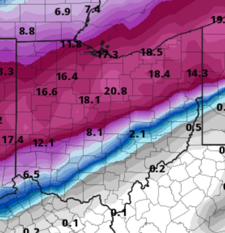
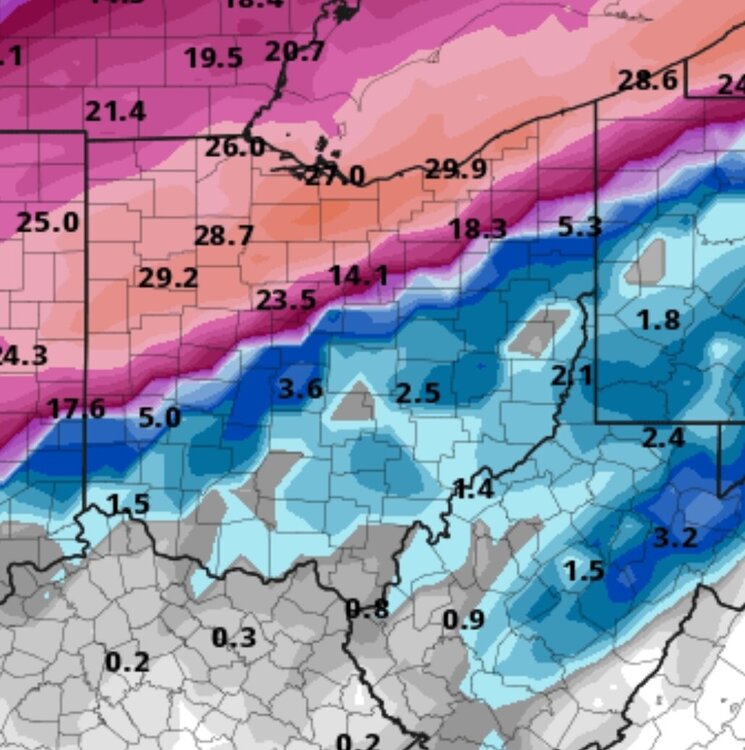
Gem for the win. Some major differences. But I'd rather the models argue with each other than the other matching with gfs.
-
1 minute ago, Floydbuster said:
Refresh my memory? What was the monster '08?
Record setting snow for cmh. March 8, 2008. Cmh recorded 20" and Much of Ohio was buried under 1-2ft of snow.
-
8 minutes ago, jaf316 said:
Yeah, I know. But I like looking at the pretty colors...
")
I'm rooting for a southeast push to give us a monster like 08 or I'm rooting for completely north whiff. I dont want 1.5" of ice like models show for me
-
1 hour ago, jbcmh81 said:
I don't actually think it would take all that much to give Columbus a decent storm. Probably wouldn't be in the axis of highest totals regardless, but it wouldn't take much more of a south move to put all of Central Ohio in the 6"+ totals, which would be on the larger side of typical storms for the area.
With Buckeye's pressing high and climo, I would hedge my bets for a storm track further south than north, though. At least right now.
Agree. Right now 50 mile shift for myself is the difference between 3" and 20"
-
47 minutes ago, jaf316 said:
Gfs clown maps on tropical tidbits give us more than a foot and a half -- but they include all frozen precip in 10:1 ratios. And verbatim it's mostly sleet/freezing rain.
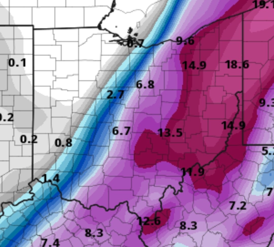
Gotta use pivotalweather for those maps. Here is the 6z from there.
-
Comical seeing tons of posts on Facebook about a "significant winter Storm for 9hio next wednesday" then people wonder why Mets are laughed at. The smart thing to do would be to wait til the one system is gone to have a better handle where the low will actually go.
-
Not here but can't say I've seen gfs show a 957mb low very often which is what it showed for east coast this weekend.
-
Radar looks good for me, but not a single flake has fallen lol.
-
So crazy. I'm in apple valley lake in knox county. My house at the back of the lake measured 6.5", the front of the lake you can still see grass. My parents place west side of the lake 3". Never seen anything like it.
-
14 minutes ago, buckeye said:
Looks like 3-5 was the right forecast for Columbus area. Can't really call it a disappointment since I don't think there were too many calls for more than that other then some of the goofy model outputs.
Yea my own calls were pretty accurate. But then you see models showing 10" so you get hopes up. While, many of the hi res models showed sleet, not many showed the dry slots that seemed to last forever. Eyeballing I'd say we got 5" or so, which would be accurate with my 4-6 call on my map.
-
 1
1
-
-
4 minutes ago, OHweather said:
I think they're a little too bullish but I think if you get into the NWS 3-5" (granted it can be argued that was a little conservative) I'd take it and run this winter. We need to get you out of the little screw hole between banding though and it should go back to snow and start accumulating quicker.
We're in heavy snow now and probably at about 3
-
1
-
-
17 minutes ago, OHweather said:
Huge bust for some of the models sure, but you’re in an advisory for 3-5” which still should be doable. Hi-res models had this mixing this evening. The low is closed off early, the warm air is wrapping in from the east. I’ve actually mixed a bit here. Any pockets of sleet will go away over the next few hours. You should still have enough liquid left to get into the 3-5” range, but 6”+ is probably off the table. I know that’s not that much after waiting this long to get something but if it hits the NWS forecast it’s hard to call it a huge bust (at least IMO). It seems like your area is sort of stuck in a little screw hole for now…things will move around but I think that’s why you’ve done so poorly and mixed so much so far. That storm last year you’re referencing stayed well under everyone’s forecasts (including mine) for a large area. I don’t think this is that, though some models will be pretty wrong for your area so it feels like you’re leaving something on the table.
Short range models still showing a lot for here. We'll see.
-
Back to sleet in knox county. This is ridiculous. I should be far enough north that this isn't an issue with this system. It's starting to look like a massive bust just like the one storm last year. It's gonna have to hammer down to even come close to model totals.
-
17 minutes ago, buckeye said:
freezing drizzle and sleet has turned to mod snow....radar looks great
Yea. Latest rap still giving huge totals. We'll see. Edit: back to a snow sleet mix 7:27pm
-
Sleet here... edit, changed to snow right after I typed it.
-
Nothing but a dusting here. Dryslot non stop. Rap still hammers, but I just have a feeling the dryslot has allowed waa to move in. Starting to look like a bust. Hopefully something changes soon.
-
Anyone else starting to get concerned? Many places reporting sleet and zr.
-
Just now, Steve said:
So we have sleet here in Newark…I have to laugh at this!
Was modeled for a short time. I'm in dry slot hell.
-
14 minutes ago, jaf316 said:
Yeah, it's looking pretty ragged. Maybe losing moisture to the coastal?
Models certainly aren't showing any moisture loss
-
Not loving the choppiness. Dry slots are killer right now. Thoughts?
-
Snow just started in knox. Let the fun begin. Dry slots.... blah...
-
18z RAP. Models picking up on what I've been thinking. That the strength of that low and totals made little sense?


“Let’s Talk Winter”
in Lakes/Ohio Valley
Posted
Pretty much stayed same. Gem was well south. Rain snow line on most were south based on my location and such. 0z NAM pretty much takes everyone out of the snow game lol