dilly84
-
Posts
4,042 -
Joined
-
Last visited
Content Type
Profiles
Blogs
Forums
American Weather
Media Demo
Store
Gallery
Posts posted by dilly84
-
-
Just now, pondo1000 said:
That system to the NW is hauling ass it seems. Is that good or bad do you guys think?
Already snowing in canton, per my cousin. So it's definitely arrived much sooner. Models didn't have snow in Central Ohio til 4 or so.
-
4 minutes ago, pondo1000 said:
Liking my 1 inch call for Powell seeing how things are setting up.
I dont lol. I think you see at least 3 or 4". Didn't you used to live in newark?
-
Snowing in Zanesville already, per report.
-
 1
1
-
-
21 minutes ago, Steve said:
Is it me or is there a big dry slot to our south…
Hi res models have it. Shouldn't effect us. Someone smarter than me, could we some thundersnow? Seems like conditions would be ripe for it.
-
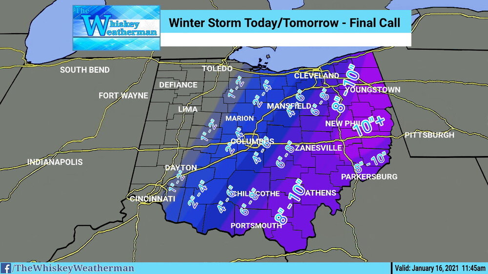
Final. Obvious hoping for over performance in the 2-4 - 4-6" area, but models aren't showing it. I just feel like the moisture shield isn't far enough west based on the low position. All we can do now is watch and hope there isn't a massive dry slot.
-
1
-
-
2 minutes ago, WHEATCENT said:
Wonder how much more we'll lose out through today. Obviously I'm farther north and east.
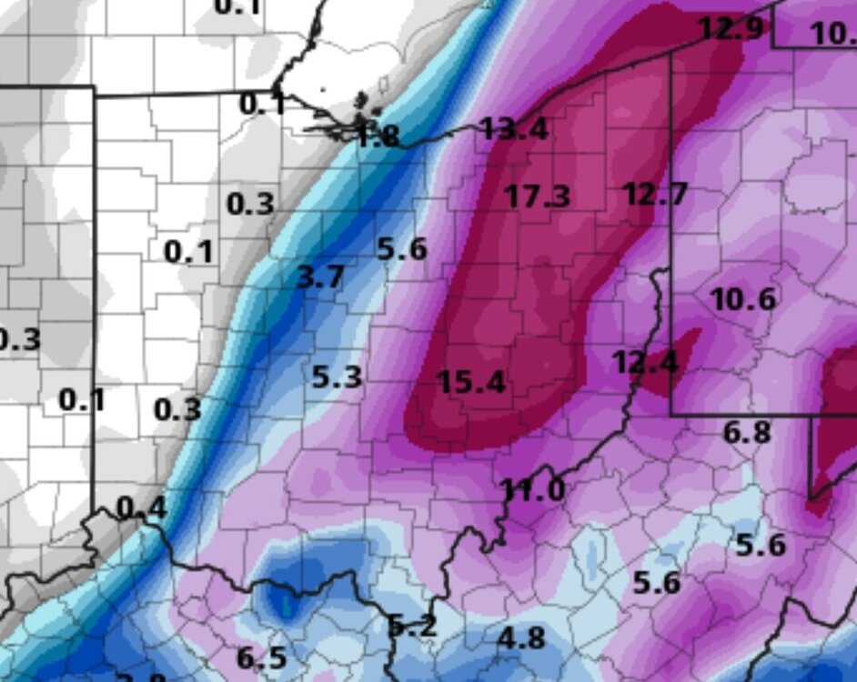
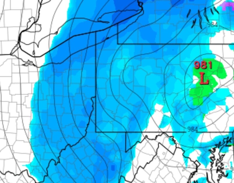
Literally looks like an apps runner, which is normally perfect for Central Ohio. BUT, I digress. May have to drop my totals a tad. I have a feeling it'll over perform, but based on 12z models so far it appears it's the moisture part is weaker. 981mb low setting in State College I'd think we'd be get hammered on models but.. here we are. If this image doesn't frustrate you, nothing will lol.
-
1 minute ago, pondo1000 said:
Coastal robbing us the moisture?
That's what it looks like. Low riding the coast, then the low moves further inland at hr 21 from Philadelphia to Gettysburg then moves north through State College.
-
So far nam and rgem have shifted the heavier precip slightly east. Nam has me on the 8" line still, but barely. Rgem has moved me to the 4" range. What is frustrating is we have about a perfect low placement for a huge snow in Central Ohio. I gotta question if the qpf is being underdone in spots like over towards CMH.
-
1 minute ago, jaf316 said:
Good call
We'll see. I hate putting anything over 8" cause we always get burned in Ohio lol. Snowing on radar not reaching ground type crap lol
-
First call. Will probably need adjustments east or west in the morning. Trends tonight were bumps west. Tight gradients make for ugly maps lol.
-picsay22.thumb.jpg.6761363546ea767e808c250343dddfbc.jpg)
-
7 minutes ago, pondo1000 said:
Is it out yet?
Hrdps looks great. Think it's hi res version of the rgem. Rgem seems to be underdoing qpf.
-
1
-
-
11 minutes ago, WHEATCENT said:
Watch every model be wrong and long range hrrr be right

Impossible. Where that low is placed we'd get pummeled in Central Ohio. That model makes no sense.
-
35 minutes ago, pondo1000 said:
Where u live
7.2"
-
1
-
-
1 hour ago, pondo1000 said:
So far…..
Pondo 1
Coach dusting
Buck 5.87 (CMH)
Steve 4
Jay 5
Dilly ??
Jaf 4.2
Vesp 5
For where?
-
1 hour ago, buckeye said:
Dilly, are you still in Newark?
Never been. I was in coshocton. Been at apple valley(near Mount vernon) for 6 years.
-
15 minutes ago, pondo1000 said:
I like it!!! Hope you’re right!
Same here. That'd put me a little higher. I love the look of the hrrr. Just doesn't have the precip far enough west compared to where the low is. I'll say this someone in central Ohio is gonna get 10" hrdps for what it is actually makes the most sense with where the low is compared to moisture. It and the nam.
-
1
-
-
3 hours ago, Gino27 said:
Seems as if a tiny difference in the stream interaction (1-3 hours) is the difference between central Ohio getting heavy totals and almost nothing. Virtually no model is accurate enough to nail that down imo.
12z nam hammers. While gfs at 6z whiffed. Waiting 12.
-
3 hours ago, WHEATCENT said:
yeah 6z gfs and granted its long range but rap and hrrr not good at all for ohio
Both are only good inside 12hrs imo. Extremely short range models. However, it is concerning that all the short range models basically whiff all of ohio outside of like 2". Fv3, hrrr, wrf are all bad for us. But I don't trust any of them outside of 6-12 hrs.
-
43 minutes ago, Gino27 said:
Nam is a disappointment
Went from 1 at 6z to 9 at 12z and 3 at 18z
-
4 hours ago, buckeye said:
For who? Indianapolis? , yes which sucks because they have been screwed worse than us and I have a soft spot for our I-70 brethren. For Columbus?....maybe if your idea of the game is getting the brunt of a storm, but for me, where we sit now IS what the game is all about. 48 hours out and riding the western edge of an incoming storm from the south with a positive nao heading neutral and no fresh arctic air mass pushing behind it during a la nina.... I'll take those odds.
I think we at least get some accumulation, I'd be really surprised if Franklin county is relegated to smoking cirrus, but who knows, the game ain't over yet.
Shield was definitely se of where it was at 0 and 6z. They've come back a bit west today, just used to being burnt here. Gets aggravating.
-
2 hours ago, Gino27 said:
Euro did some weird crap. Came west with precip but ULL was east. Tomorrow will be very interesting
Game over.
-
1 hour ago, jaf316 said:
NAM seems to be falling in line with the rest of the gang -- looks like we're getting fringed again...
Yup I said earlier after 12z it was easy to see where this was going. Everywhere BUT ohio will get a decent storm out of this.
-
1 hour ago, jaf316 said:
Gfs goes SE, Euro goes NW... Gonna be a long few days...
The low on the GFS actually appears to be further west than yesterday, but the precip shield on the back isn't nearly as far north.
-
14 minutes ago, pondo1000 said:
Big swing & and a miss on 12z NAM
Calling it now, miss sw. NW trend is done and the trend back SW begins. As I said a few days ago, ready for the torch already.
-
1
-

-picsay22.jpg.ea299472e18a2c857927afe552a74ad2.jpg)
“Let’s Talk Winter”
in Lakes/Ohio Valley
Posted
18z NAM