

dilly84
-
Posts
4,041 -
Joined
-
Last visited
Content Type
Profiles
Blogs
Forums
American Weather
Media Demo
Store
Gallery
Posts posted by dilly84
-
-
5 minutes ago, CoachLB said:
I wait on the one from COD. It has the kutchera ratio’s. It runs about 45 minutes behind pivotal.
Nam has finally came around. What is cod?
-
11 minutes ago, pondo1000 said:
Don’t forget to post your final call map here!
My call
-
 1
1
-
-
5 minutes ago, pondo1000 said:
Don’t forget to post your final call map here!
I dont care to get dragged lol
-
34 minutes ago, CoachLB said:
12z euro is looking decent
2hrs late on that one lol
-
6 minutes ago, TheClimateChanger said:
Not sure if the RAP is tracking the same storm as the other models, or if a weenie took over the controls?
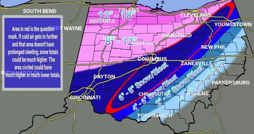
The heavy amount at bottom isn't taking into account sleet.
-
1
-
-
Rap model has the freezing rain/snow line running through Guernsey County. So quite a bit se of many others.
-
Gfs and ukie have been the only 2 models that's remained consistent for the last 3 days. I think I'm gonna ride with the gfs.
-
20 minutes ago, Gino27 said:

Here's the maps I just posted on my twitter page. I'm riding with the warmer guidance for now. The system seems a little bit moisture starved as of now, and I think that will reduce dynamic cooling.
Shouldn't need dynamic cooling. That high should have no issue getting cold air in against the weak low. Low has perfect placement, and the setup in general is perfect. Each meso run creeps further southeast. Idk what I'm going with yet. I'm watching a bit more than doing my final.
-
2
-
-
Rgem definitely moved south this run. Still puts us on the line of sleetfest. A line from stark to franklin.
-
6z Nam small bump south. 6z HRRR didn't look good.
-
Canadian still horrible. Worst modeling I've seen. There's not much consensus in any of em.
-
Just now, buckeye said:
Who has a link for a good precip-type radar?
Ashamed to admit I just use accuwx's
-
 1
1
-
-
Just now, buckeye said:
Pretty much
Again, perfect placement. Low through Eastern KY to near Morgantown or so, yet keeps us sleet the entire time. Sigh. It appears no model is going to cave, so apparently it's take your pick. Unless... GFS caves 0z.
-
1 minute ago, CoachLB said:
Rgem sucked!
Low was doing all kinds of weird stuff but was still in a good spot when it wasn't moving all around.
-
26 minutes ago, buckeye said:
Not much. I think rgem is going to be an improvement....hard to tell on the crappy black and white maps.
Looks the same in the end.
-
Just now, pondo1000 said:
HRW looks good
Yea that's that fv3 I asked buckeye about. I dont know the accuracy
-
1
-
-
1 minute ago, buckeye said:
I wouldn't take the hrrr seriously until later tomorrow. The extended hrrr is trash.
What do you know about this fv3 model? It's been great for us today.
-
6 minutes ago, Gino27 said:
3k nam is much better and seems to reflect the 500 changes much better too.
A little, still doesn't give us much more than 2" of snow.
-
So far we're 0-2. 0z Nam and 0z HRRR both no good.
-
1 minute ago, NTXYankee said:
0z NAM a massive sleet storm for counties along both sides of 71, granted better than freezing rain but ugh, a block of ice with the cold air.
Perfect low placement though.
-
Nam looking even worse than 18z early on. When do we start taking it seriously?
-
Just now, NTXYankee said:
Well I can get why Ohio people have their own discussion, the main thread for this storm is Chicago, Chicago, Chicago and all points around. Typical of any other event in the Ohio Valley if it doesn’t impact Chicago it’s not worth discussing. I seriously hope this storm isn’t a massive ice producer here, would be devastating but not as confident we avoid that along 71 as I was earlier.
I don't even go read the other thread because of it lol. I just stay here like I have for 16 years lol
-
2
-
-
40 minutes ago, buckeye said:
You guys remember that one 2 years ago in January. Started off as rain and sleet and was suppose to changeover but it took hours longer than expected. The local meterologists caught all kinds of hell.

Don't remind me. My little page of 600 followers gave me all kinds of hell and I'm not even a met lol. I had to explain what I'm explaining now, that these south to north type systems are hard to predict the day of let alone 2 days out. But everyone was wrong with it, so I didn't feel bad lol
-
2 minutes ago, buckeye said:
still looking like either a big snow or a sleetfest. We probably won't have a better handle until this thing is on radar and moving towards us tomorrow afternoon.
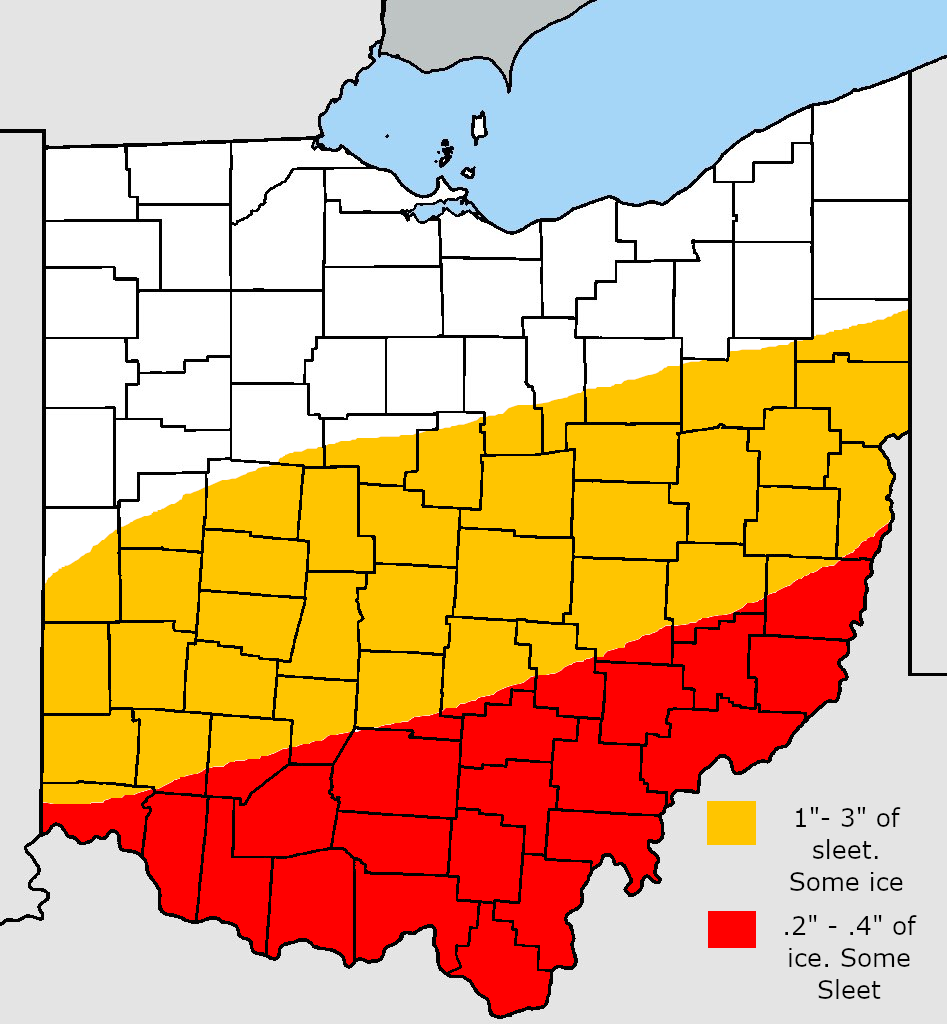
Guess the positive is that outside of southeast Ohio it appears freezing rain may not be as big of an issue
-
1
-
“Let’s Talk Winter”
in Lakes/Ohio Valley
Posted
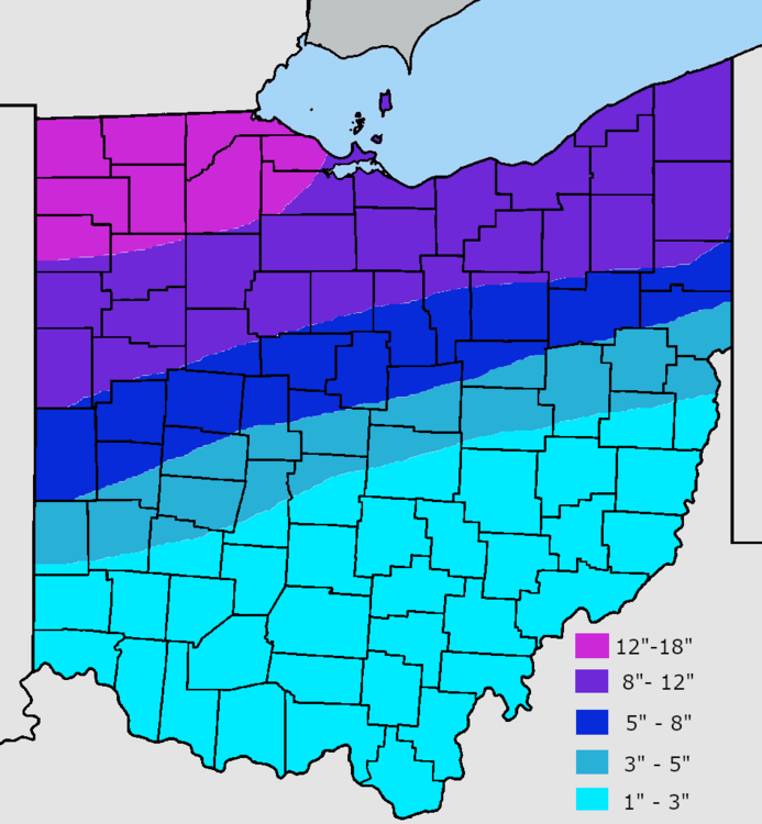
Sref plumes have several over 8"