The 4 Seasons
-
Posts
7,720 -
Joined
-
Last visited
Content Type
Profiles
Blogs
Forums
American Weather
Media Demo
Store
Gallery
Everything posted by The 4 Seasons
-
-

Clipper Fires In Wednesday Feb 25 Disco/ Obs
The 4 Seasons replied to Damage In Tolland's topic in New England
Doesnt surprise me. There was an event earlier in Jan where we had around an inch in the morning right down to the shore and BDR reported T. -
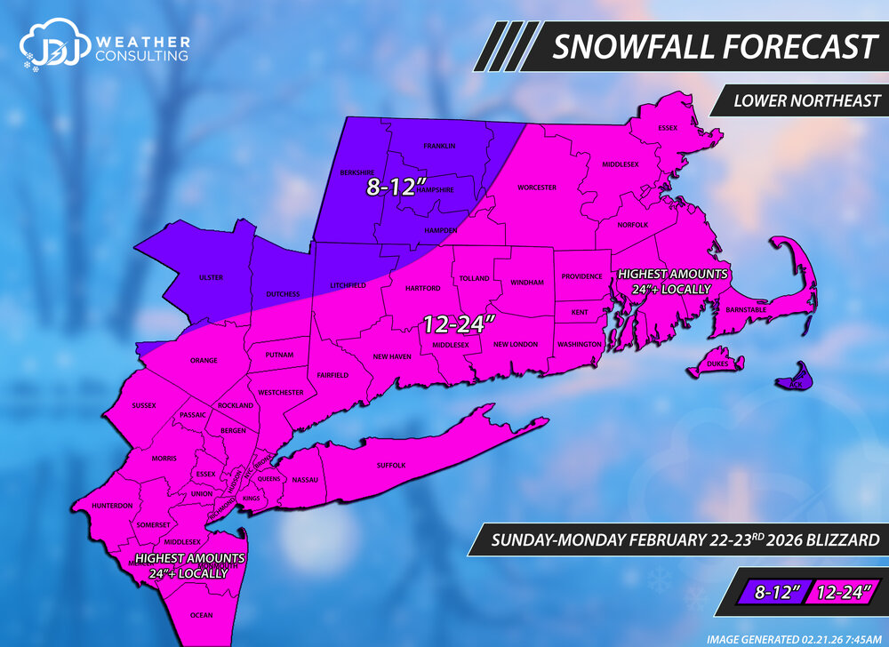
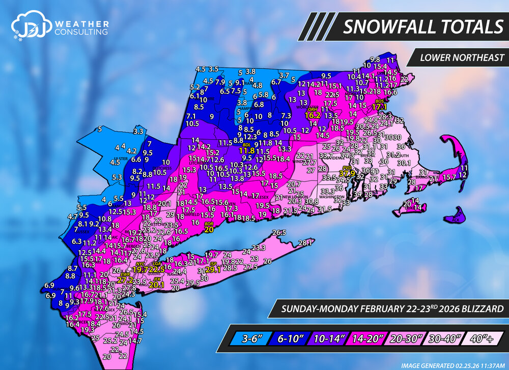
Snowfall totals map for this historic February 22-23, 2026 Blizzard. As always thanks for everyone who sent me reports. Data is from here, cocorahs, COOP and official sites. This L Northeast is all i have done so far after about 16 hours it was a massive undertaking. I tried to include all reports but some don't fit and had to be excluded. The site will be updated soon but these maps are not up yet. This will be the 2nd historic storm of the season and ill have everything including a full radar animation up on the site in the coming days. There is some incomplete data on the PNS and NWS snowfall maps so beware. BOX is only using 1-day cocorahs totals for some reason and not including both days, so a ton of the reports are very low that say "cocorahs" next to them. OKX did the same thing but instead of only including the 23rd they mostly just used the 22nd. On a technical note there is exactly 398 reports on here from well over 1,000 sifted through, probably closer to 2k. This was only the 4th time ever including a 40"+ snowfall contour for all the events i've done. Gotta say this is one the coolest looking snowfall maps ive ever produced. I mentioned earlier the forecast for CT was very good to great. For the overall region it was probably a C/C+? Too low for SE MA/NJ even though i put 24"+ in text, that is not sufficient and it needed a whole new range of 24-36+. Too high for NW MA and Catskills. Our final call was the same as the first but i had a 2nd and final update ready to go where i had SE MA/NJ in a 24-36" range but never posted/released it. I figured the first call was good and didn't want to change the map if i didnt have to but in retrospect im kicking myself a bit for not doing so. Oh well. The Tri-State only map is not done yet but will be coming soon. If there is anything missing or needs to be adjusted let me know. With these big storms, this probably wont be the true final....with an error or two or additional/changed reports needed. First and Final Call
-
"Don’t do it" 2026 Blizzard obs, updates and pictures.
The 4 Seasons replied to Ginx snewx's topic in New England
fyi I just posted the final region wide snowfall map in the snowfall totals thread -
Snowfall totals map for this historic February 22-23, 2026 Blizzard. As always thanks for everyone who sent me reports. Data is from here, cocorahs, COOP and official sites. This L Northeast is all i have done so far after about 16 hours it was a massive undertaking. I tried to include all reports but some don't fit and had to be excluded. The site will be updated soon but these maps are not up yet. This will be the 2nd historic storm of the season and ill have everything including a full radar animation up on the site in the coming days. There is some incomplete data on the PNS and NWS snowfall maps so beware. BOX is only using 1-day cocorahs totals for some reason and not including both days, so a ton of the reports are very low that say "cocorahs" next to them. OKX did the same thing but instead of only including the 23rd they mostly just used the 22nd. On a technical note there is exactly 398 reports on here from well over 1,000 sifted through, probably closer to 2k. This was only the 4th time ever including a 40"+ snowfall contour for all the events i've done. Gotta say this is one the coolest looking snowfall maps ive ever produced. I mentioned earlier the forecast for CT was very good to great. For the overall region it was probably a C/C+? Too low for SE MA/NJ even though i put 24"+ in text, that is not sufficient and it needed a whole new range of 24-36+. Too high for NW MA and Catskills. Our final call was the same as the first but i had a 2nd and final update ready to go where i had SE MA/NJ in a 24-36" range but never posted/released it. I figured the first call was good and didn't want to change the map if i didnt have to but in retrospect im kicking myself a bit for not doing so. Oh well. The SNE only map is not done yet but will be coming soon. CT as well. If there is anything missing or needs to be adjusted let me know. With these big storms, this probably wont be the true final....with an error or two or additional/changed reports needed. First & Final Call


-
ok thanks, yeah i know Jack. Thats great to know because those two reports line up extremely well so part of me thought they were the same reporter, good stuff. Vary narrow band of 20"+ in W CT, those reports are really close which is good for such a big long duration windy storm, i was just surprised to see 22 and 21 right next to each other
-
"Don’t do it" 2026 Blizzard obs, updates and pictures.
The 4 Seasons replied to Ginx snewx's topic in New England
definitely... that whole package in that video is just something that would be absolutely priceless, i mean just amazing to have for every storm (at least modern storm)..man. -
"Don’t do it" 2026 Blizzard obs, updates and pictures.
The 4 Seasons replied to Ginx snewx's topic in New England
so like 45ish? The accordion man claims 50 in that storm. I dont see any official reports higher than 38 or 39. I saw unoffically from the NWS that Lincoln reported 55" and drifts to 27'. But reporting was god awful back then so its not hard to believe 50 or 55. -
"Don’t do it" 2026 Blizzard obs, updates and pictures.
The 4 Seasons replied to Ginx snewx's topic in New England
what site/software is that with that radar and all those overlays etc? Something private, in house stuff or is that from a paywalled site you think? @dendrite -
Clipper Fires In Wednesday Feb 25 Disco/ Obs
The 4 Seasons replied to Damage In Tolland's topic in New England
2.0" yet another suite of maps to do, literally can't keep up btw the full set of Feb 22-23rd Blizzard snowfall totals maps coming within a couple hours on the snowfall totals thread. -
Clipper Fires In Wednesday Feb 25 Disco/ Obs
The 4 Seasons replied to Damage In Tolland's topic in New England
should be over in 10-15 -
Clipper Fires In Wednesday Feb 25 Disco/ Obs
The 4 Seasons replied to Damage In Tolland's topic in New England
1.0" hopefully get to 2 id be cool with that -
Clipper Fires In Wednesday Feb 25 Disco/ Obs
The 4 Seasons replied to Damage In Tolland's topic in New England
i never heard of a 3 hour day in the 2000s. I was just thinking about that yesterday! saw a first 3 hour hour delay ever, i didn't know they started doing those. -
Clipper Fires In Wednesday Feb 25 Disco/ Obs
The 4 Seasons replied to Damage In Tolland's topic in New England
thats one way to get to 20 -
Clipper Fires In Wednesday Feb 25 Disco/ Obs
The 4 Seasons replied to Damage In Tolland's topic in New England
days and days S CT winning this one -
Clipper Fires In Wednesday Feb 25 Disco/ Obs
The 4 Seasons replied to Damage In Tolland's topic in New England
lolz
-
Clipper Fires In Wednesday Feb 25 Disco/ Obs
The 4 Seasons replied to Damage In Tolland's topic in New England
hey how much did you get in the storm? i have no reports from Belchertown -
Clipper Fires In Wednesday Feb 25 Disco/ Obs
The 4 Seasons replied to Damage In Tolland's topic in New England
HRRR FTL big L -
Clipper Fires In Wednesday Feb 25 Disco/ Obs
The 4 Seasons replied to Damage In Tolland's topic in New England
Just broke 50".gif.d8a5fd33cb7879ada36fb2c2787bffec.gif)
-
Clipper Fires In Wednesday Feb 25 Disco/ Obs
The 4 Seasons replied to Damage In Tolland's topic in New England
Bad timing for schools -
Clipper Fires In Wednesday Feb 25 Disco/ Obs
The 4 Seasons replied to Damage In Tolland's topic in New England
-
Clipper Fires In Wednesday Feb 25 Disco/ Obs
The 4 Seasons replied to Damage In Tolland's topic in New England
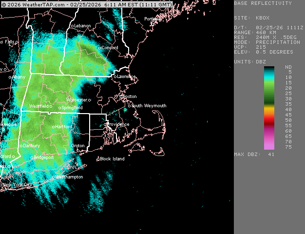
Yeah, its very heavy didnt expect inch+ per hour rates out of this thing -
Clipper Fires In Wednesday Feb 25 Disco/ Obs
The 4 Seasons replied to Damage In Tolland's topic in New England
Just hit S+ with excellent growth this winter rules -
Clipper Fires In Wednesday Feb 25 Disco/ Obs
The 4 Seasons replied to Damage In Tolland's topic in New England
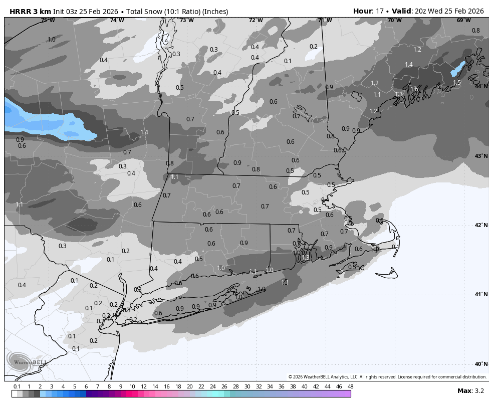
wasn't supposed to really. Radar looks more impressive than some of the hi res stuff would suggest. A 2-4hr dump at good rates should net us 1-2. FV3 actually looks the most accurate to whats happening right now on radar. -
Clipper Fires In Wednesday Feb 25 Disco/ Obs
The 4 Seasons replied to Damage In Tolland's topic in New England
would be nice but im thinking somewhere in the neighborhood of an inch here, maybe 2. HRRR has like virtually nothing now for most of CT, it's initializing horrible. The first frame looks nothing like radar and it just trended worse and worse every run. Just an observation @Sey-Mour Snow