
The 4 Seasons
-
Posts
6,379 -
Joined
-
Last visited
Content Type
Profiles
Blogs
Forums
American Weather
Media Demo
Store
Gallery
Posts posted by The 4 Seasons
-
-
46 and light rain.
This "storm" isn't big enough to have a seperate obs thread so just continue to post em here. Unless mods want to seperate.
-
25 minutes ago, Baroclinic Zone said:
Pivotal Weather does not look this at all.

I used 22Z on the HRRR, and it's 10:1 not kuchera. If that is 10:1 then the hour is off or the run is off because here is the same run as TT, 22Z at 18 hours and shows more than your picture.
.thumb.png.1a62bd436037d1fc8f1b001ab9060caa.png)
-
1 minute ago, ineedsnow said:
Dropping like a rock here.. snow soon?
Soon. I bet theres some flakes flying in the NW hills of Norfolk by now. Anybody from the hills with obs?
-
ECMWF juiced up a bit for CT, improved from 12Z. Looks good.
-
Just now, Mr. Windcredible! said:
HRRR is ticking up a bit with each run too. Calls for 1-3” look good at this point. Maybe someone sniffs 4” if banding sets up just right.I can't argue with that, i was debating going down to 1-3 but decided to stay at 2-4, im liking what im seeing with the radar, model trends and obs right now.
-
Mt. Tolland jacking every run..Kevins been running the HRRR this storm

-
FINAL CALL:
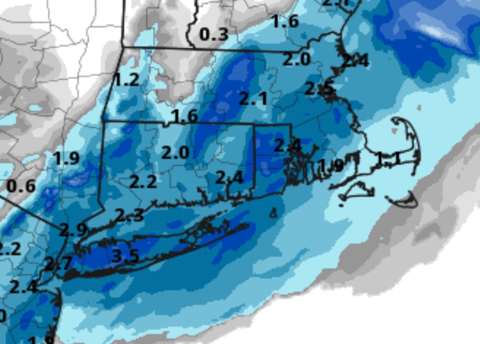
Not much change at all, bumped up numbers in Litchfield hills. Still thinking a greater accumulation away from the immediate coast.
Interested to see how this plays out. Radar looks bueno.

-
 1
1
-
-
HRRR bumping up little by little each run is nice to see.
-
I know it's not really comparing apples to apples but the radar right now (seems) to look a lot better than progged fx radars at this hour from the NAM/HRRR and other models.
Alot of the obs are light though some a couple SNs

.gif.c7bdf153eca1320a2d54b2831e9efbbc.gif)
-
1
-
-
4 minutes ago, Ericjcrash said:
There's no cure for herpes.
That's just that panel though later frames when its snowing aren't so bad. Its still good for most but what ive noticed is the heavy axis of snowfall/banding has shifted 10-20 miles SE every single run for the past 5 runs

-
HERPES gonna cut back a bit but still decent for CT and most of SNE
-
2 minutes ago, moneypitmike said:
I have to think this antecedent warmth will limit some of the accumulation. It's still 50* here.
I think its definitely going to take time to get going especially on the roads. Probably lose our first inch or so that falls just to melting, even on non paved surfaces.
-
For comparison. Not too much change, backed off a smidge, shows what Will is talking about. I was speaking more with a CT focus


-
I really like this Enhanced Data Display that the NWS came out with but it's been "Experimental" for like 5 years now or as long as i can remember.
CF just off to our NW (of the state)

-
Yea thats a big steaming pile of do do
It was showing signs of life coming back west a bit but now it literally has 0.0 over central CT.
-
6 minutes ago, Baroclinic Zone said:
Little bit less but it looked virtually identical to 12z. Noise.
This is pretty much was i saw @CoastalWx
-
7 minutes ago, CoastalWx said:
RGEM off the sauce and back East.
Based only off whats out so far the Candian Centre Progs it doesnt look too much different from 12Z to me, still a good hit for CT. Still on the higher side of things too it would seem.
-
15 minutes ago, weatherwiz said:
Looks like there is an unstable layer in there...but also looks like there is sinking motion within it.
Here is 850 RH at 9z...all the good lift is just above this...I don't think we'll have issues generating snow but we will have problems getting it to the ground. This is why I think the radar may be a bit deceiving tomorrow...especially the higher up the beam is hitting

what site is this
-
1 minute ago, Sugarloaf1989 said:
Hoping for a 2-3" pack refresher here.
You still have it? I was really curious about you guys up north with all this rain and 50s and snow eating fog how much would be left after today
-
1 minute ago, Ginx snewx said:
ORH is still looking for there’s from last Sunday
A winter weather advisory for 8-13 and now for 1-4
-
1 minute ago, Ginx snewx said:
Nice crush job Euro 18th
That's been there for the past 3 (main) runs too. Nice to see
-
2 minutes ago, Baroclinic Zone said:
PM?
lol, just thinking about that. Where are my warnings.
to be frank, the advisories are a stretch and the nws knows it, mostly for timing/impacts as we mentioned.
-
3 minutes ago, Typhoon Tip said:
starting to sniff like despite all that's transpired across this 'hoping journey' ... the original insights and experience may prevail.
waste
of
time
A couple inches or so (2-3) here was all i was really expecting from the start, that happens ill be satisfied.
But yes i can't wait for this little turd to flush down the toilet so we can start tracking something real.
-
Just now, OceanStWx said:
You get some leeway with criteria (theirs is 3") if you want to say impacts will be a problem. They can claim the commute will make 1 or 2 inches problematic and thus issue an advisory for it.
That's exactly what they said in the disco actually. It's sub advisory pretty much everywhere. Timing is bad but i don't think roads will be as i said before. I'm pretty certain that 91 and 95 will be just wet. Side streets esp in hilly terrain have issues if we can get some good banding.
Is this the latest criteria that you're aware of?


.png.ab937f2f66f6acca2ce6951631522477.png)


Wednesday 12/11 SNE Snow Threat
in New England
Posted
Rain. 43F.