
The 4 Seasons
-
Posts
6,379 -
Joined
-
Last visited
Content Type
Profiles
Blogs
Forums
American Weather
Media Demo
Store
Gallery
Posts posted by The 4 Seasons
-
-
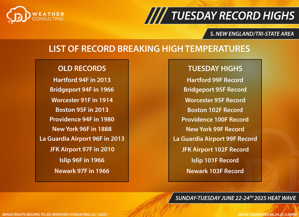
Mon, Tue, Wed record highs and Wed highs compared to old records for all 10 climo sites in BOX/OKX. I doubled checked everything this time so hopefully no errors


-
 1
1
-
 1
1
-
-
9 minutes ago, weathafella said:
BOS hit 90 Monday
you're right, i made this right after the pm climo (CLI) came out and it was 85, the next update was at 1am and they changed it to 90, i didnt notice. Looks like they hit 90 really late (7-8pm) after the winds switched from E to S. ill update it, thx for the info.
Still no record tho

-
1
-
-
4 minutes ago, dendrite said:
ORH was 95F today
typo, thanks
fixed
-
Records yesterday and today for all SNE/Tri-State climo sites.
*Fixed ORH typo
**Updated BOS Monday high

-
1
-
-
21 hours ago, H2Otown_WX said:
Hell yeah man, thank you. Appreciate your hard work. Look at that radar loop for December 2000. That's a sexy storm and a rare distribution these days with west beating east.
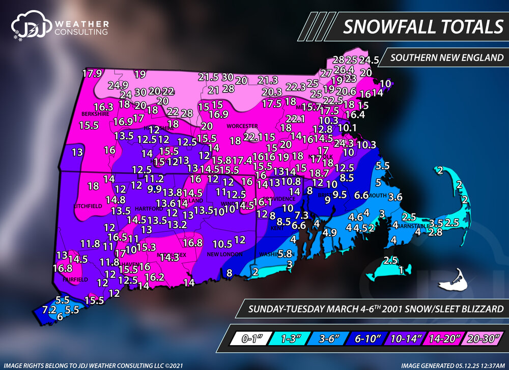
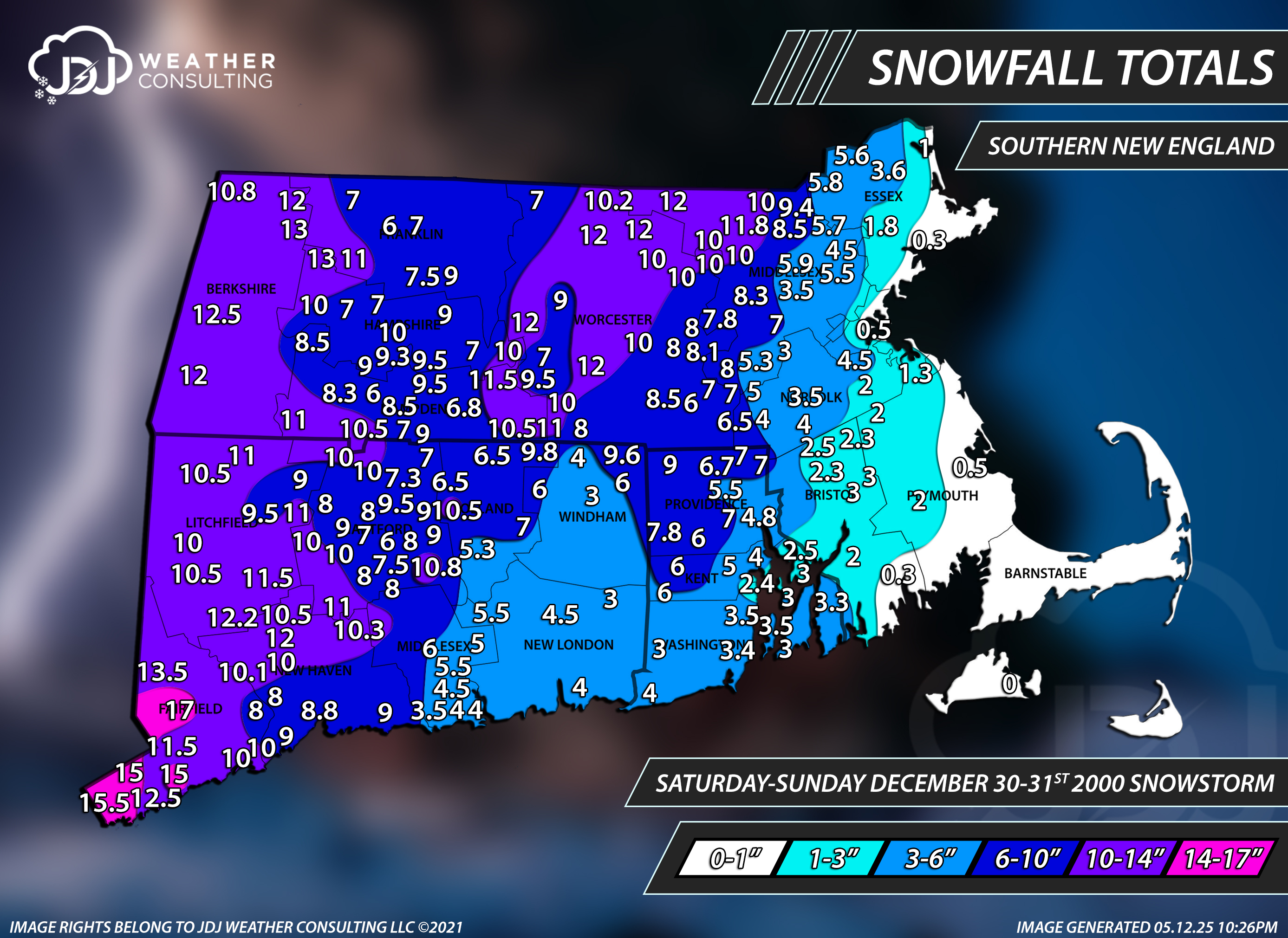
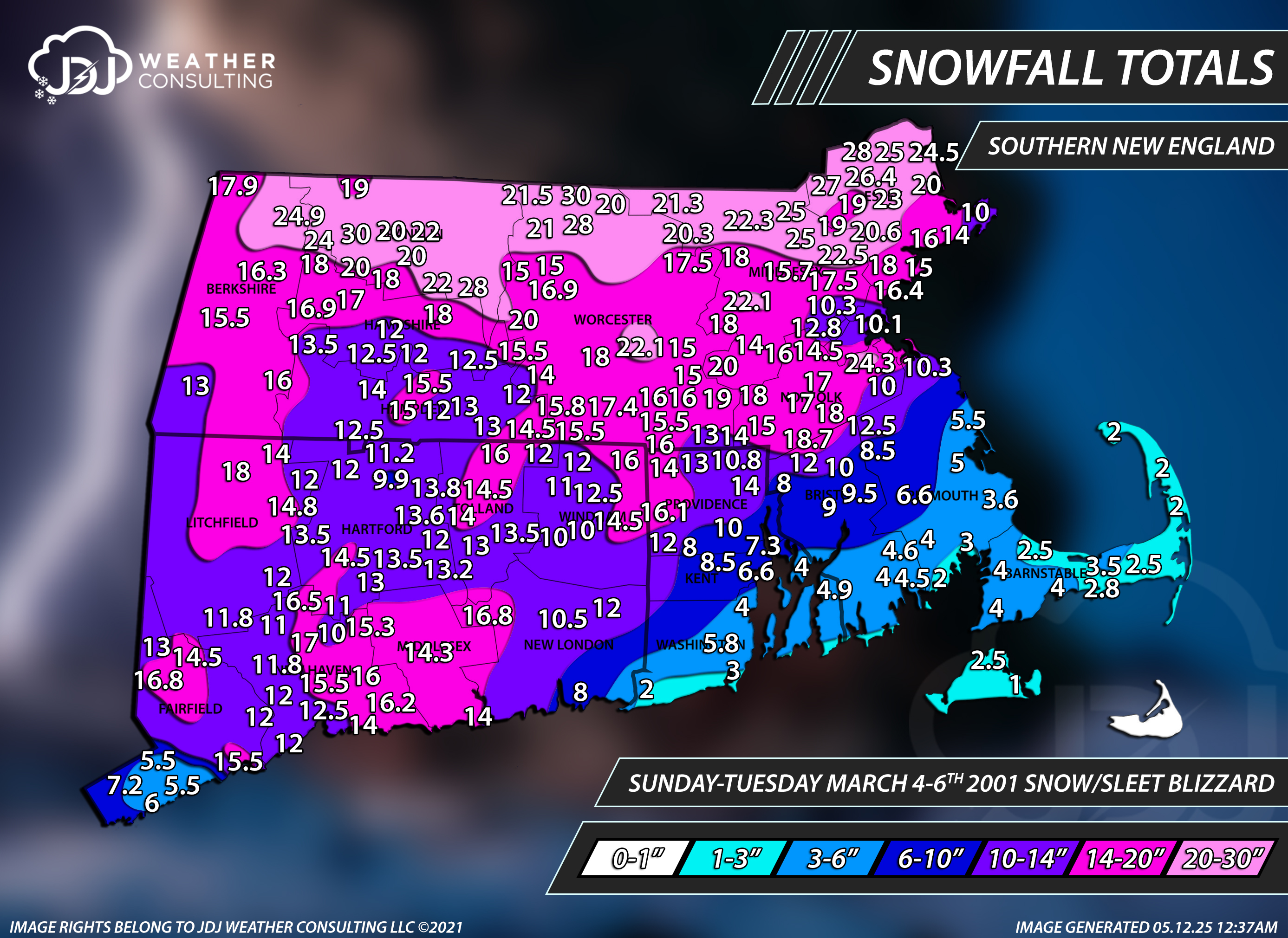
For sure. Mar 4-6 2001 was one hell of a storm despite under performing a bit in CT. Still a solid 10-18 for most of the state. I was pretty much right on with my memory of that storm, snow began late Sunday AM and the last flakes ended just after midnight Wednesday morning. About 62 hours.
-
1
-
1
-
-
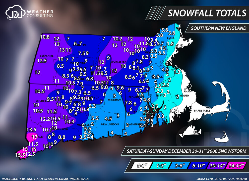
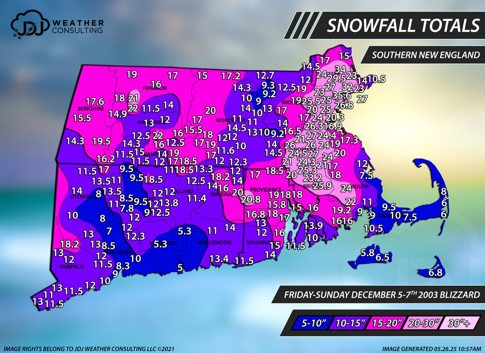
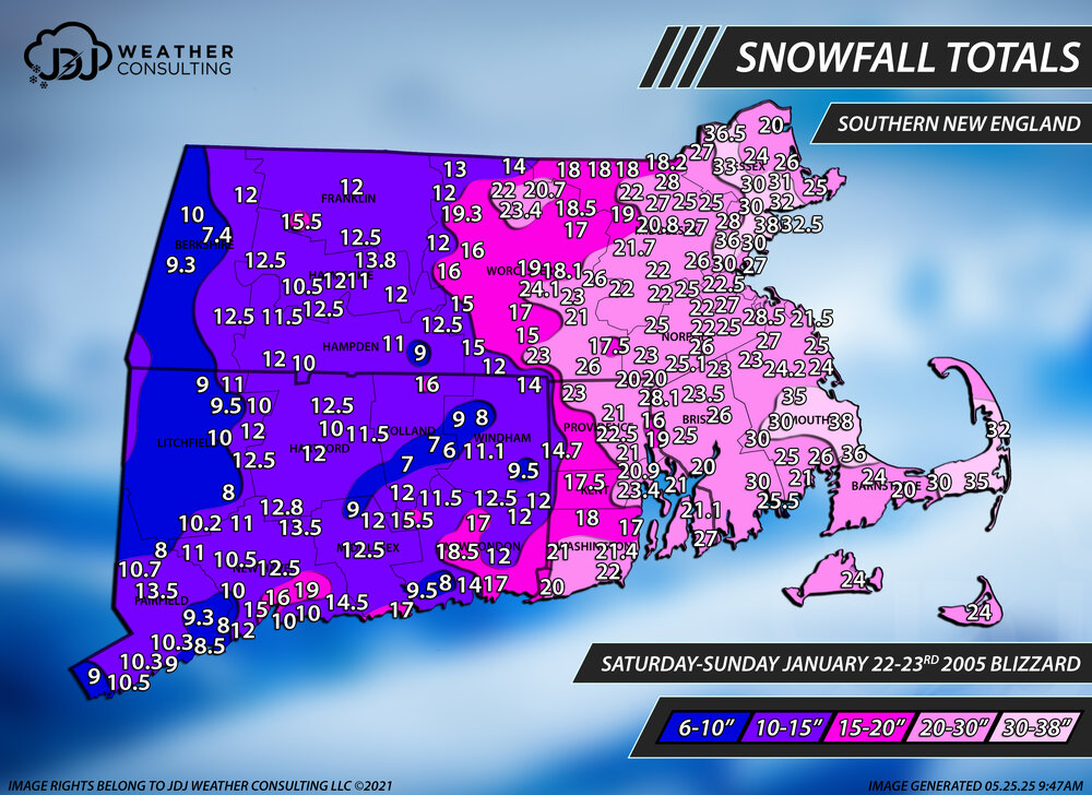
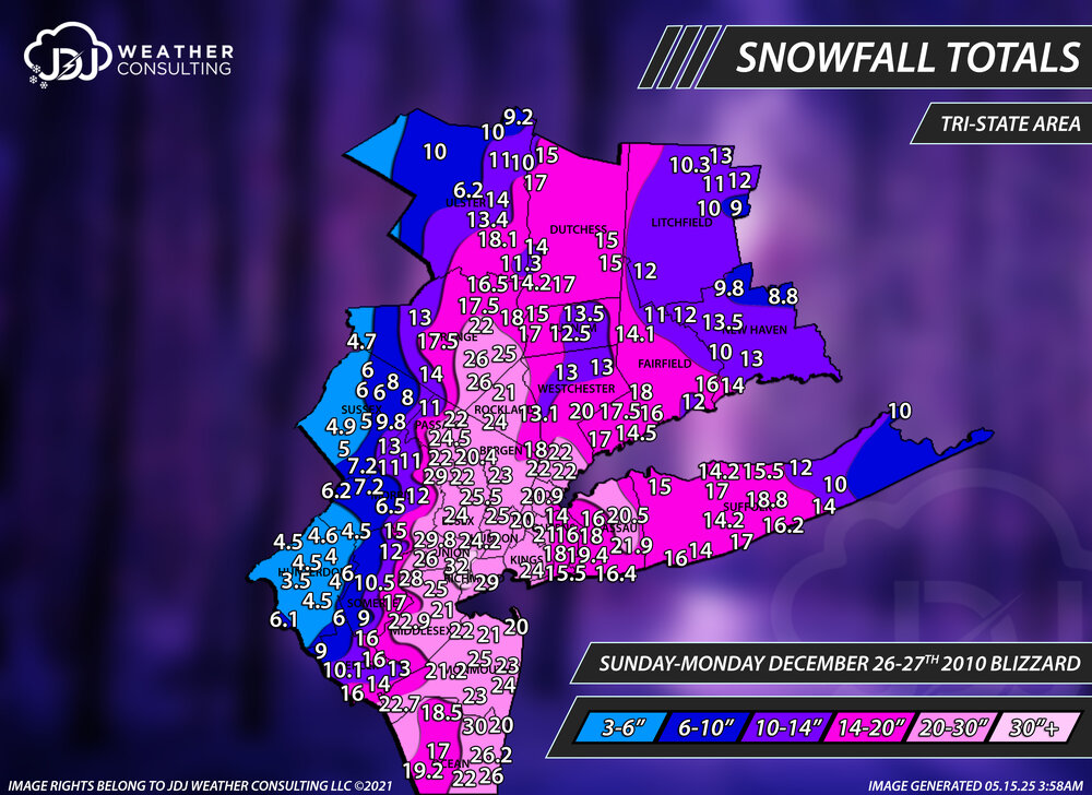
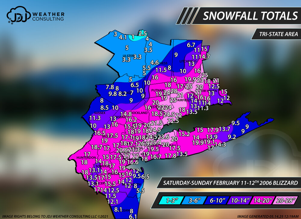
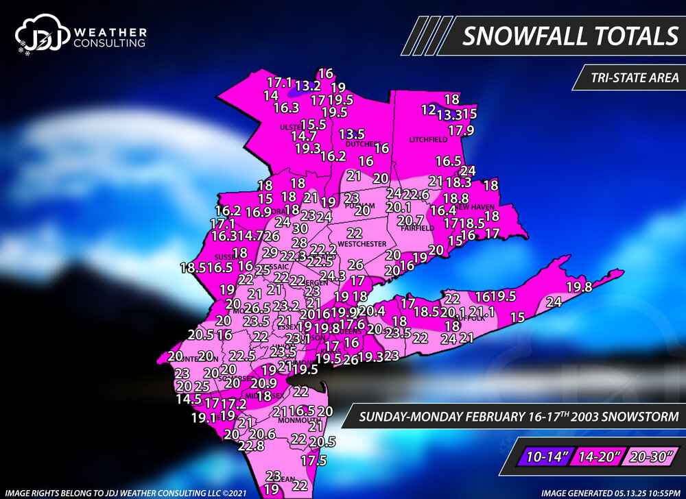
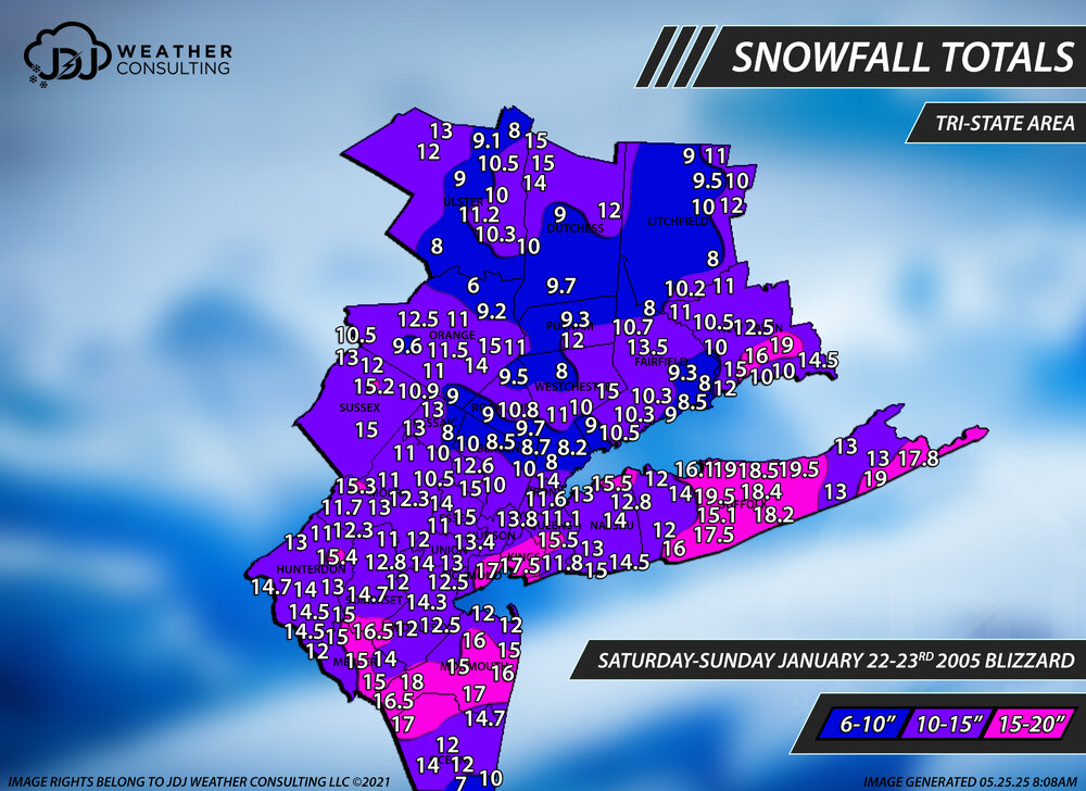
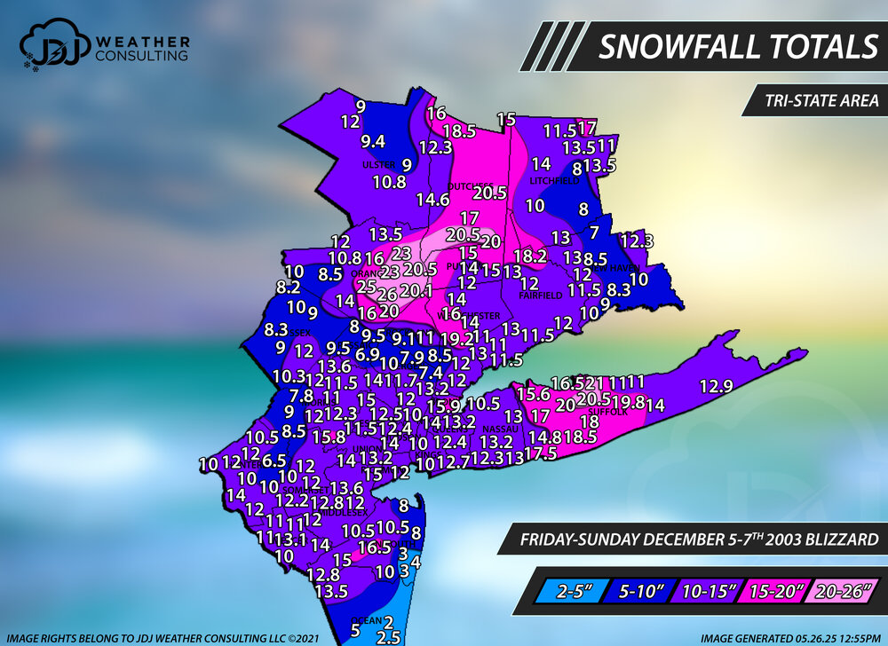
Hey @H2Otown_WX i just added a full radar loop of your favorite storm Dec 30th 2000 and Feb 5th, Mar 4-6th 2001 as well as Dec 2003 and Jan 2005. Even the blizzard of 96 is now up. All new snowfall maps as well. I cant link them here cuz the file sizes are massive.
-
2
-
-
50 minutes ago, LibertyBell said:
Yay the entire 1995-96 season and especially the January 1996 blizzard are in there too?
The storms I really want to see are January 1996, PD2 February 2003 and January 2016 of course !!!
I'd love to see April 1982 and February 1983 but I don't think you'll go that far back..... will you?!
The main archive that has all the storms is updated back to 2018-2019 so far and will stop at 2000 (probably take me till sometime in 2026)
The historic archive has all 12"+ big/historic storms and 1996 and PD2 is there and about 20 others, which is also being worked on
The big thing recently was adding radar and tri-state maps to all the storms
-
1
-
-
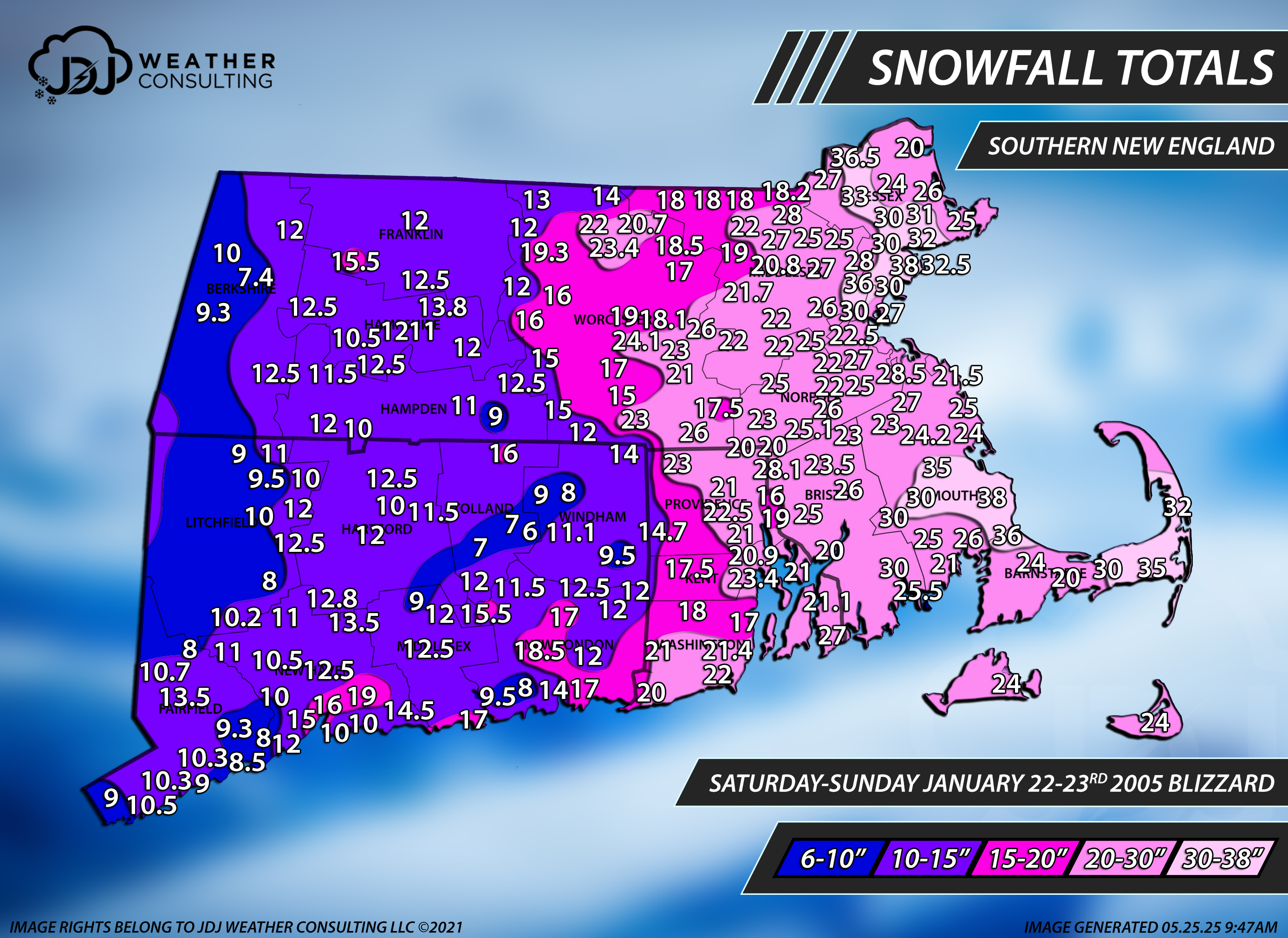
Hey everyone i just updated our Historic Storms page on our site to include Tri-State Area snowfall maps for every event as well as a full radar loop for all storms post 1995. There's a lot of new storms in there including Boxing Day, PDII, Feb 2006 Blizzard, Dec 2003, Jan 2005 and of course Mar 4-6 2001, Dec 2000 and more. I'll be continuing to update it with more new storms throughout the year.
https://www.jdjweatherconsulting.com/historic-storms
-
1
-
1
-
-
On 2/18/2025 at 9:05 AM, EastonSN+ said:
Thanks as always @The 4 Seasons
If there was one enhancement to your site that I would love to see are radar loops for the past storms. Perhaps a bit too ambitious however great to relive.
There is now. I found two archives for radar. There is now a new section of the site that has radar loops for the entire event as well sfc and h5 maps for past moderate events (3"+) or higher. It's being updated on a weekly basis but i am back 5 years now to 2020. https://www.jdjweatherconsulting.com/storm-archive
-
4
-
-
I don't know if i've ever seen this map this empty before, for a second i thought it didn't load.
It's quiet out there, a little too quiet
-
4
-
-
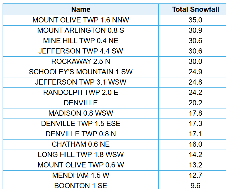
3 minutes ago, MANDA said:
Had 30.9" at my location. Except for 3 events of between 5 and 6" I could have done without the remaining nuisance 1-2" events.
Nevertheless a total is a total and compared so some totals on this map even into the Catskills, mid Hudson Valley and NW CT I did well.
Nice. I saw that on the COOP but i think i just included the 4.4SW Jefferson 30.6". Some of these are so close together i can't fit them all but that 30.9 matches up pretty close to the 30.6, which was also in Mine Hill
-
2
-
-
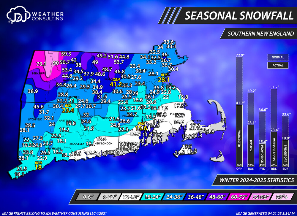
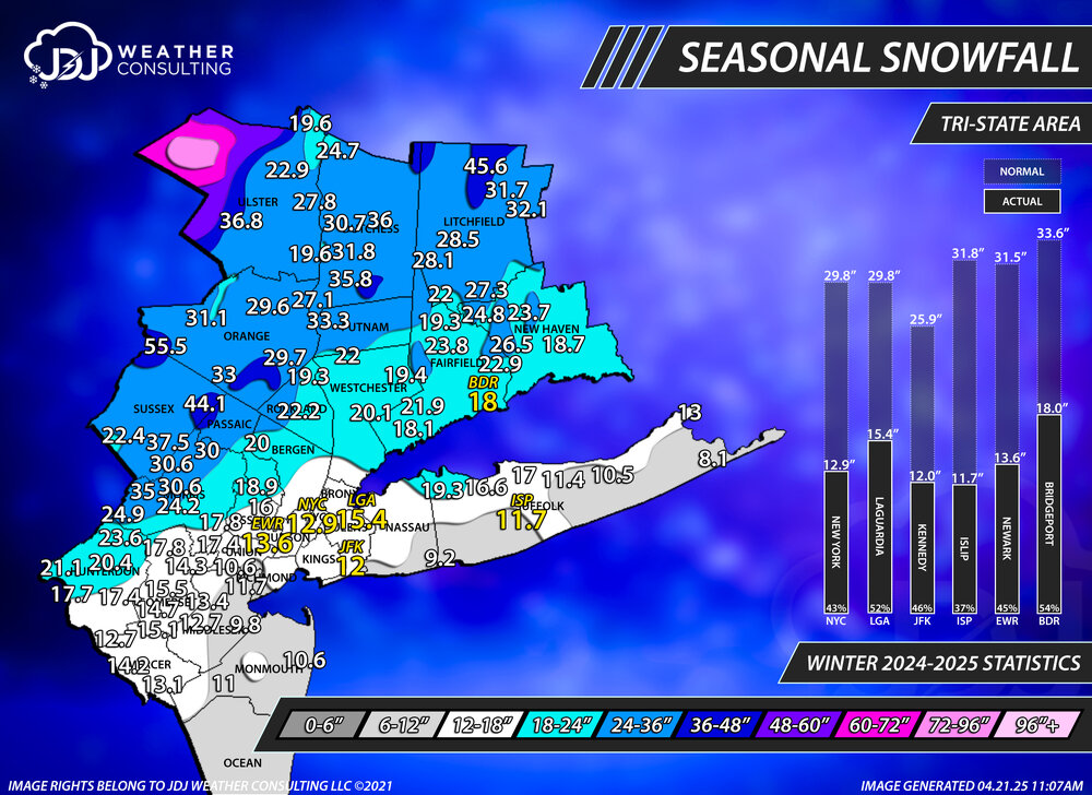
Final seasonal snowfall totals for the 24-25 season. I added some stats on the side for the climo sites and compared them to normal.
There's a snowfall progression animated GIF throughout the season as well as Tri-State/CT maps on our website under the 24-25 seasonal snowfall page.
-
2
-
6
-
-
Update for the 24-25 season totals FINAL.
-
1
-
-
Just finished the final seasonal snowfall map for the 24-25 season. I added stats to the side for the climo sites as well as a progression throughout the season which you can see on our site. Everything is updated in the 24-25 snowfall maps page.
-
9
-
-
Updated for 24-25 season snowfall final totals. CT/SNE/Tri-State/Northeast maps on our site as well as snowfall progression throughout the season and statistics for climo sites.
-
1
-
1
-
-
If anyone has any seasonal snowfall totals that have changed since March 10th let me know what your current season snowfall total is. Especially looking for anyone in Sussex, Orange, Putnam, Rockland, Westchester, Dutchess and Ulster counties. I'll be doing a final season snowfall map probably this week.
-
5 minutes ago, LibertyBell said:
will you be going back to at least the Blizzard of 1996
")
No probably just 2000. But that's already up on the historical section with maps https://www.jdjweatherconsulting.com/jan-1996
-
1
-
-
5 hours ago, FPizz said:
Very cool. Selfishly, I wish Ray hadn't stopped with his website since I am in NJ, but thanks for doing this
Yeah his site is really something else. After working on this i have a unique appreciation for how much time went into doing something like that. For example he has 127 storms listed from 1993-2013 and each storm has 15 individual pages for different levels, radar, sfc, etc making for a total of about 1,905 unique web pages. Something like that takes years to put together. Not to mention he did a snowfall map for NJ for every storm. I tried to email him but got no reply, that was about a month ago.
I feel like a lot of what is up on his site was done in coordination with someone at the NWS and CIPS because for example, you can't find any of those snow maps on the CIPS site. If i could post all the maps like he did, i would...but every reference link he has up is dead, like every single link. However, what we will have that is different from his site is a full radar loop of the entire event as well as surface and H5 animated loops. Since you're in New Jersey, we do have a tri-state map for every event that covers most of New Jersey. I just finished adding most of the 21-22 season this week. Working on the final event today and then 20-21.
-
1
-
1
-
-
1 hour ago, Brian5671 said:
felt downright tropical after the lousy 2 week stretch since that 80 degree day
I remember that day. Serious back door. I dont think ive ever seen mid 30s and mid 80s at the same time in CT, that was wild.
We were only in the 50s here with a forecast of 70
-
1
-
-
8 hours ago, SACRUS said:
just a little sun will do the trick.
Made it up to 72 here what a great day easily the best of the year so far. Finally feels like Spring.
-
1 hour ago, LibertyBell said:
Wow we had a 7 inch total in our area?
It would be interesting to see what the highest totals in the Poconos were.
Phoenicia, NY in ulster county, 830FT. It's a report from COOP
-
1
-
-
3 minutes ago, SACRUS said:
Some breaks into S NJ with sun. If we cant get more prooucned clearing upper 60s and 70 will be hard to achieve.
thats rough, already 65 here
-
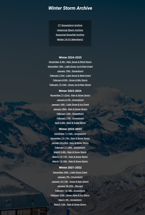
There is a new Winter Storm Archive i am working on to be an alternative to Ray's Winter Storm Archive that ended at the 2012-2013 season. Right now our site mostly just has snowfall maps and is more focused on CT. With this new archive i will be going backward and creating snowfall maps for every moderate event (3"+) for all of Southern New England and the Tri-State Area. Each page will not only have the snowfall maps but a full radar loop of the entire event, a surface map loop of the Northeast, daily surface weather map loop of the US and a H5 US loop.
So far i've completed back to 2021-2022 so you can see the first 4 seasons. I will be working on this continually throughout the spring summer and fall and hopefully get back to 2000 by the start of next season. Check back continually because the site will be updated every week going forward. I'll probably do a post explaining everything and all the changes at the start of the 25-26 season.
-
3
-
2
-
-
1 hour ago, Damage In Tolland said:
1.2” Thursday night
and a half inch i saw when i scrolled the pages from Friday night? I didn't see the 1.2 but i saw the 0.5


June 2025 discussion-obs: Summerlike
in New York City Metro
Posted
Record highs mon-wed and wed records