
paulythegun
-
Posts
976 -
Joined
-
Last visited
Content Type
Profiles
Blogs
Forums
American Weather
Media Demo
Store
Gallery
Everything posted by paulythegun
-
-

The Weekend Rule? Saturday 2/17 - The Icon Storm
paulythegun replied to DDweatherman's topic in Mid Atlantic
Spring-like night-time rain in DC. Should add to the mosquito population. -
The Weekend Rule? Saturday 2/17 - The Icon Storm
paulythegun replied to DDweatherman's topic in Mid Atlantic
41/26 and raining in NE DC. My guess is that the earth is not warming at all. I’m a big stupid idiot. -
The Weekend Rule? Saturday 2/17 - The Icon Storm
paulythegun replied to DDweatherman's topic in Mid Atlantic
The “flagship model” made me chuckle -
The Weekend Rule? Saturday 2/17 - The Icon Storm
paulythegun replied to DDweatherman's topic in Mid Atlantic
The precip orientation is great for Philly! . -
The Weekend Rule? Saturday 2/17 - The Icon Storm
paulythegun replied to DDweatherman's topic in Mid Atlantic
What counts as underperforming? The precip max shifted 80 miles north in the past 24 hours so what baseline do we even use? -
The Weekend Rule? Saturday 2/17 - The Icon Storm
paulythegun replied to DDweatherman's topic in Mid Atlantic
41/24 with a slight north trend out of the south in NE DC -
The Weekend Rule? Saturday 2/17 - The Icon Storm
paulythegun replied to DDweatherman's topic in Mid Atlantic
-
The Weekend Rule? Saturday 2/17 - The Icon Storm
paulythegun replied to DDweatherman's topic in Mid Atlantic
at least it's NORTH arlington -
The Weekend Rule? Saturday 2/17 - The Icon Storm
paulythegun replied to DDweatherman's topic in Mid Atlantic
Delete the thread and start another? -
The Weekend Rule? Saturday 2/17 - The Icon Storm
paulythegun replied to DDweatherman's topic in Mid Atlantic
-
The Weekend Rule? Saturday 2/17 - The Icon Storm
paulythegun replied to DDweatherman's topic in Mid Atlantic
FINAL MAP -
The Weekend Rule? Saturday 2/17 - The Icon Storm
paulythegun replied to DDweatherman's topic in Mid Atlantic
Time for the 12z day before the storm tradition: posting idiotic models while we wait for the Euro. The 12z ARPEGE. Still waiting for the GDAP/UM(mmmm) model to run. -
The Weekend Rule? Saturday 2/17 - The Icon Storm
paulythegun replied to DDweatherman's topic in Mid Atlantic
I've been keeping it in the panic room. But GFS was actually colder on this run so the north trend was mitigated a bit. Stilll.....knife's edge! -
(keeping these in the panic room to avoid spoiling the jolly mood) i may chase north. latest GFS is amazing....and actually the column is a bit colder! but as a resident of Mt. Hamilton in NE DC, i don't care for this trend. i always figured this one would be heavy snow into street puddles in the city but with so much snow just north, worth chasing...
-
NORTH. But on the bright side, LWX has temps never reaching freezing in the city until Saturday at 9pm!
-
uh oh. North Trend!
-
The Weekend Rule? Saturday 2/17 - The Icon Storm
paulythegun replied to DDweatherman's topic in Mid Atlantic
Looking at the timing here...NAM 3k has about 3-4 hours of precip falling for the city, but well over 0.1" an hour. In other words: definitely set your alarm if you want to see some fatty pukage tonight. -
https://x.com/hotwxexpert/status/1758358847951958038?s=46
-
The Weekend Rule? Saturday 2/17 - The Icon Storm
paulythegun replied to DDweatherman's topic in Mid Atlantic
GRAF is in -
The Weekend Rule? Saturday 2/17 - The Icon Storm
paulythegun replied to DDweatherman's topic in Mid Atlantic
I need an app that wakes me with an alarm any time snow rates go above an inch per hour. -
The Weekend Rule? Saturday 2/17 - The Icon Storm
paulythegun replied to DDweatherman's topic in Mid Atlantic
Yeah it might be time to delete the thread and start a new one if that happens -
The Weekend Rule? Saturday 2/17 - The Icon Storm
paulythegun replied to DDweatherman's topic in Mid Atlantic
Kuchera (as I understand it) is highly sensitive to the maximum temperature in kelvin in up to 500mb (Tmax below). I ran the calculation for DC for the Euro where the max temp is 273..15 in Kelvin (0 degrees C) during the height of the storm and that translates to 8.01 to 1 ratios using the Kuchera method.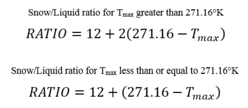
-
The Weekend Rule? Saturday 2/17 - The Icon Storm
paulythegun replied to DDweatherman's topic in Mid Atlantic
Move your cars!!! -
The Weekend Rule? Saturday 2/17 - The Icon Storm
paulythegun replied to DDweatherman's topic in Mid Atlantic
woof


