
paulythegun
-
Posts
976 -
Joined
-
Last visited
Content Type
Profiles
Blogs
Forums
American Weather
Media Demo
Store
Gallery
Everything posted by paulythegun
-

2024 Valentines Day Rain/Snow/Who The Hell Knows Thread
paulythegun replied to WinterWxLuvr's topic in Mid Atlantic
- 563 replies
-
- 13
-

-

-
2024 Valentines Day Rain/Snow/Who The Hell Knows Thread
paulythegun replied to WinterWxLuvr's topic in Mid Atlantic
Solly's is a great place to watch snow fall (if it's accumulating on streets). They have those big bay windows with 180 degree views (added after a cabby had a seizure and crashed into the place in I think 2005). -
2024 Valentines Day Rain/Snow/Who The Hell Knows Thread
paulythegun replied to WinterWxLuvr's topic in Mid Atlantic
12z NAM 84hr is way north of 6z GFS. more amped too. -
Don't worry! The extended GFS/ECMWF models still look like El Nino analogs like they have all winter! [emoji848][emoji848][emoji848]
-
24 hours later..................................
-
-
12z GFS was a Panic Room CLASSIC. Just amazing stuff. I agree with others though that the takeaway should be largely positive here. We're seeing multiple strong waves ride under us with plenty of moisture.
- 2,509 replies
-
- 2
-
-
- weenie fest or weenie roast?
- weenies got roasted
- (and 2 more)
-
This made me chuckle. wonderful!
-
The Insult Each Other Room
-
Long range looks really good. There's no reason to be posting in here. But if I WERE going to post, I'd say, "March looks like at least 3 HECS rain storms"
-
Not in the cemetery!
-
Day 15-20 looks like a period of interest in terms of starting to track March snow puddles after the February precipitation drought.
-
Can somebody tell me the exact moment when the wave breaks? I'm very excited for the wave to break. Also, when does the snow pattern make landfall? Have we sampled it yet? What about 06z/18z? Do we need more balloons?
- 2,509 replies
-
- 7
-

-
-

-
- weenie fest or weenie roast?
- weenies got roasted
- (and 2 more)
-
For Feb 6th, 72hr into the 12z Euro, seeing some good confluence.....over the bahamas
- 2,509 replies
-
- 4
-
-
- weenie fest or weenie roast?
- weenies got roasted
- (and 2 more)
-
Jan/Early Feb Medium/Long Range Discussion Part 3
paulythegun replied to WinterWxLuvr's topic in Mid Atlantic
ECMWF keeps hope alive for the 5th/6th (I guess). Slower, a bit north. 00z Euro had these two features (circled) crash down and seemingly whisk whole thing out to sea. 12z euro doesn't' have them. -
Jan/Early Feb Medium/Long Range Discussion Part 3
paulythegun replied to WinterWxLuvr's topic in Mid Atlantic
Yeah I've always had this (noob) question of whether a higher resolution model could "trick itself" by aggressively identifying noise (smaller features) and failing to smooth those out. But I guess that's just a convective feedback loop? -
Jan/Early Feb Medium/Long Range Discussion Part 3
paulythegun replied to WinterWxLuvr's topic in Mid Atlantic
4 out of 20 members of CMC Ens have snow reaching here Feb. 5/6. Two have a liquid explosion. Therefore, 10% chance of a liquid explosion. That's how this works. -
Jan/Early Feb Medium/Long Range Discussion Part 3
paulythegun replied to WinterWxLuvr's topic in Mid Atlantic
The last 5 runs (here it comes! rain bomb!) -
Jan/Early Feb Medium/Long Range Discussion Part 3
paulythegun replied to WinterWxLuvr's topic in Mid Atlantic
For the 5th/6th, EPS has these three panels + 48 panels of nothing or almost nothing. -
haha the euro smashes that thing to oblivion on Feb 5th. Smashes it back into the gulf of mexico from whence it came
-
Jan/Early Feb Medium/Long Range Discussion Part 3
paulythegun replied to WinterWxLuvr's topic in Mid Atlantic
-
Jan/Early Feb Medium/Long Range Discussion Part 3
paulythegun replied to WinterWxLuvr's topic in Mid Atlantic
I wonder what the analogs are for this one -
Jan/Early Feb Medium/Long Range Discussion Part 3
paulythegun replied to WinterWxLuvr's topic in Mid Atlantic
GFS Ext. Control AO collapses into negative infinity LMAO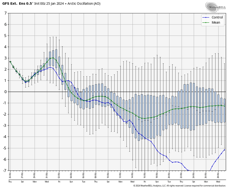
-

