RIC Airport
-
Posts
2,586 -
Joined
-
Last visited
Content Type
Profiles
Blogs
Forums
American Weather
Media Demo
Store
Gallery
Everything posted by RIC Airport
-
Richmond Metro/Hampton Roads Area Discussion
RIC Airport replied to RIC Airport's topic in Mid Atlantic

-
Richmond Metro/Hampton Roads Area Discussion
RIC Airport replied to RIC Airport's topic in Mid Atlantic
Now this is old school cold!!!
-
Richmond Metro/Hampton Roads Area Discussion
RIC Airport replied to RIC Airport's topic in Mid Atlantic
Verbatim surface temps at RIC remain below freezing throughout the event. But, we rise above 0°C at 850mb for a time, unfortunately. I'm sure 00z will offer a different solution.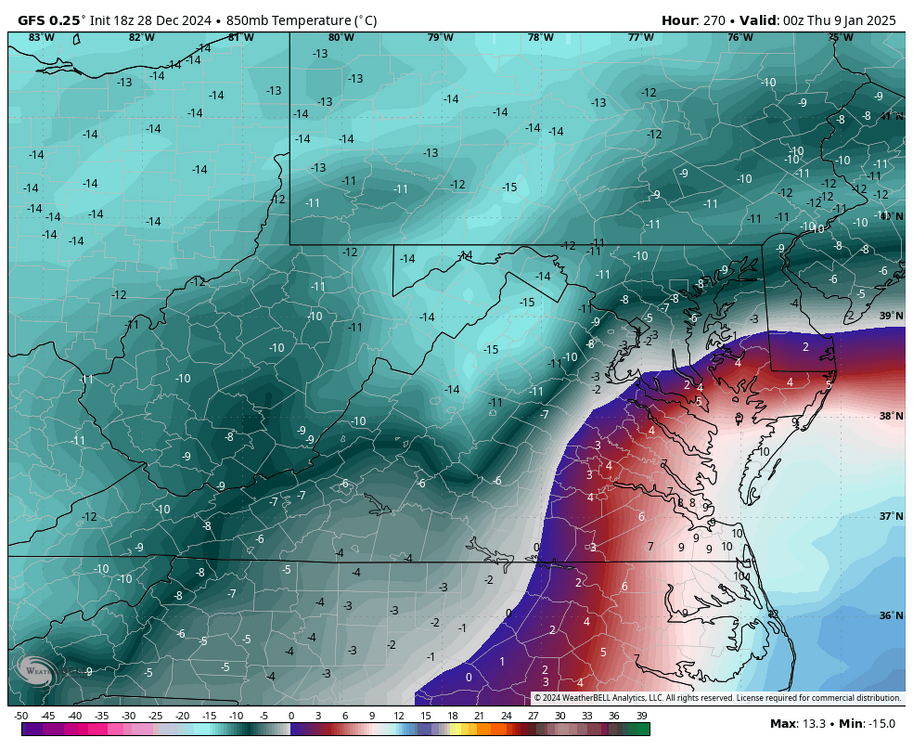


-
Richmond Metro/Hampton Roads Area Discussion
RIC Airport replied to RIC Airport's topic in Mid Atlantic

-
Richmond Metro/Hampton Roads Area Discussion
RIC Airport replied to RIC Airport's topic in Mid Atlantic
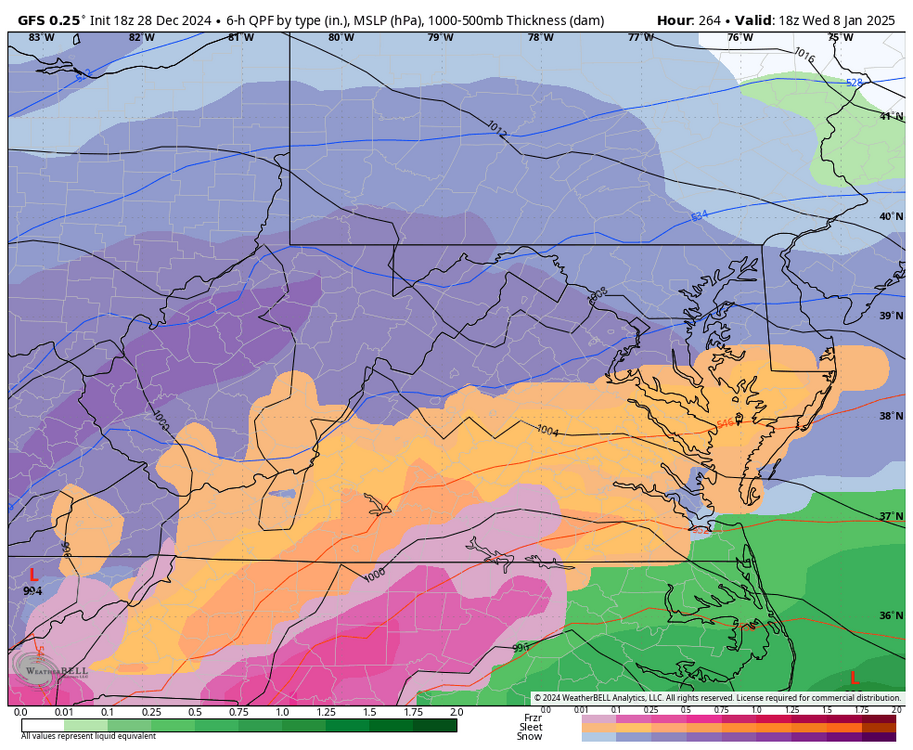
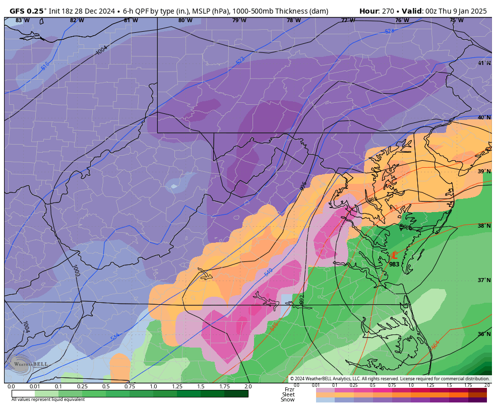
Looks like we get a front end thump, but change to IP/ZR. -
Richmond Metro/Hampton Roads Area Discussion
RIC Airport replied to RIC Airport's topic in Mid Atlantic
Christmas Eve 2022 had a low of 8°F and a high of 24°F. -
Richmond Metro/Hampton Roads Area Discussion
RIC Airport replied to RIC Airport's topic in Mid Atlantic
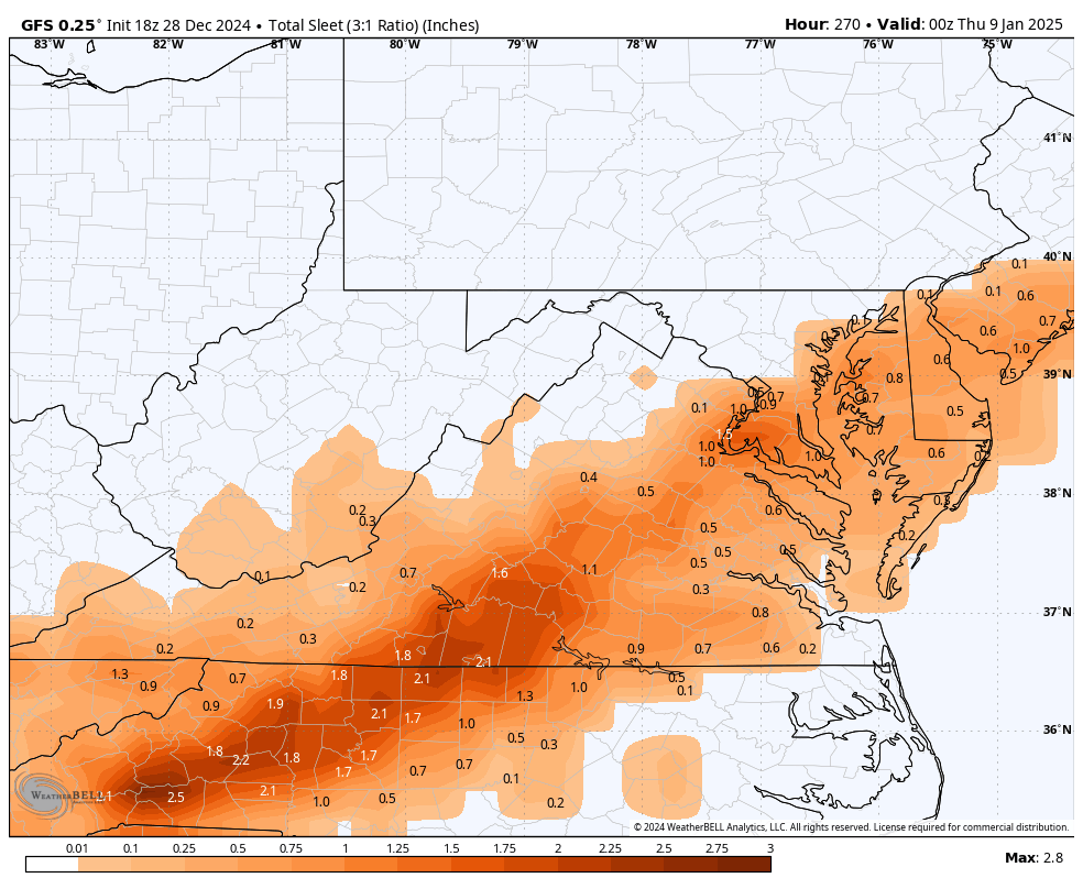
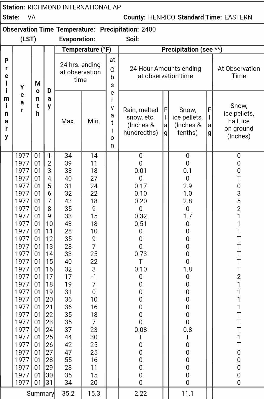
Although no month is ever the same, but I see January 1977 coming up a lot as an analog. It was RIC's second coldest January (after 1940) on record. Looks like there was a 7" snowstorm early in the month before the motherlode of cold arrived mid-month with highs only in the teens and even a below 0°F reading. There was at least a trace of snow on the ground most of the month. The last time there was a high temperature below 20°F at RIC was back in February 1996. Most recently there was a high of only 21°F in February of 2015. The most recent below 0°F reading at RIC was in January 2018 when it hit -3°F at the airport.
-
Richmond Metro/Hampton Roads Area Discussion
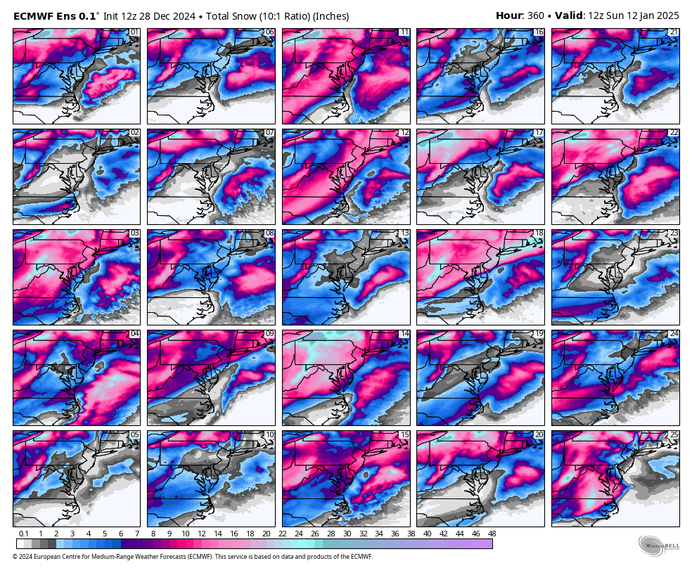
RIC Airport replied to RIC Airport's topic in Mid Atlantic
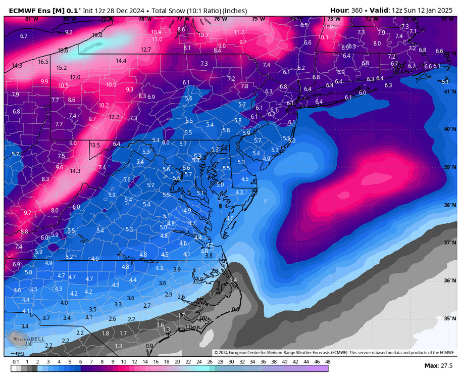
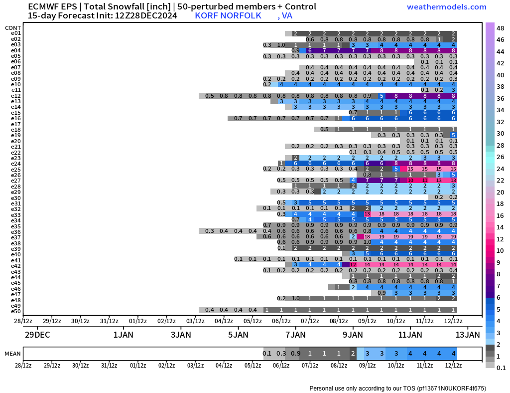
12Z EPS snow charts for RIC and ORF..thumb.png.a0c341b035633336f2825f09b985d08e.png)

-
Richmond Metro/Hampton Roads Area Discussion
RIC Airport replied to RIC Airport's topic in Mid Atlantic
Just got done.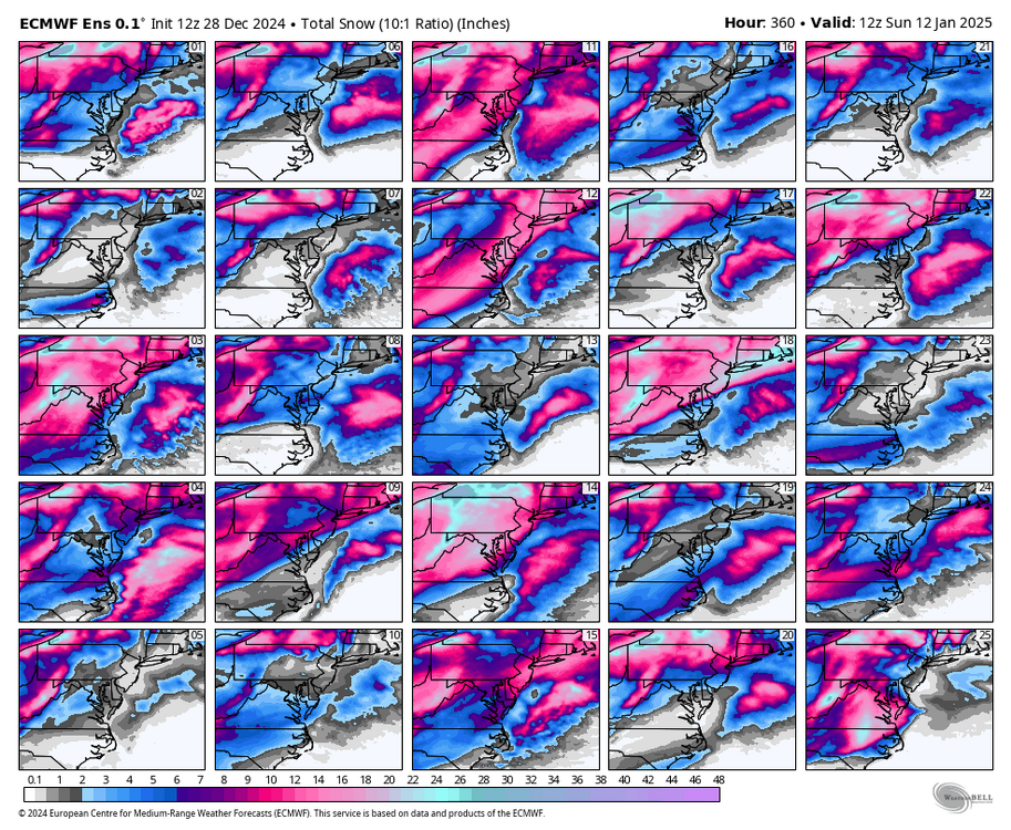
-
Richmond Metro/Hampton Roads Area Discussion
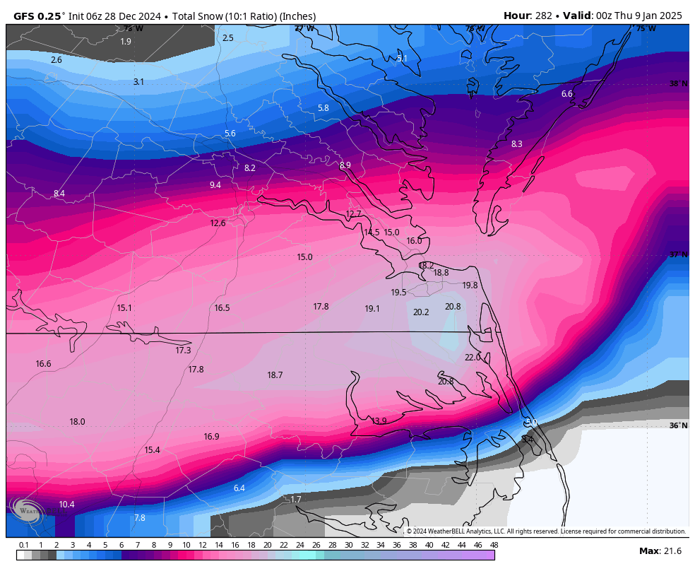
RIC Airport replied to RIC Airport's topic in Mid Atlantic
Yes, I don't recall seeing a 5 inch mean at all last year. Individual members are still running, will post when they are done, and charts too! -
Richmond Metro/Hampton Roads Area Discussion
RIC Airport replied to RIC Airport's topic in Mid Atlantic
12Z GFS and Euro OP runs were basically cold and dry. The 12z EPS mean came in quite healthy, nearly 5" at RIC.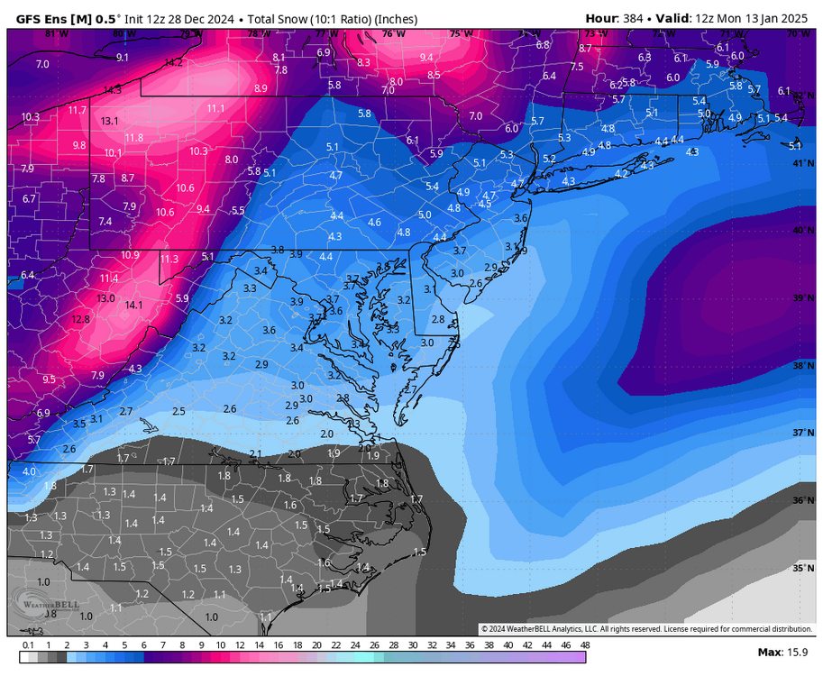
-
Richmond Metro/Hampton Roads Area Discussion
RIC Airport replied to RIC Airport's topic in Mid Atlantic
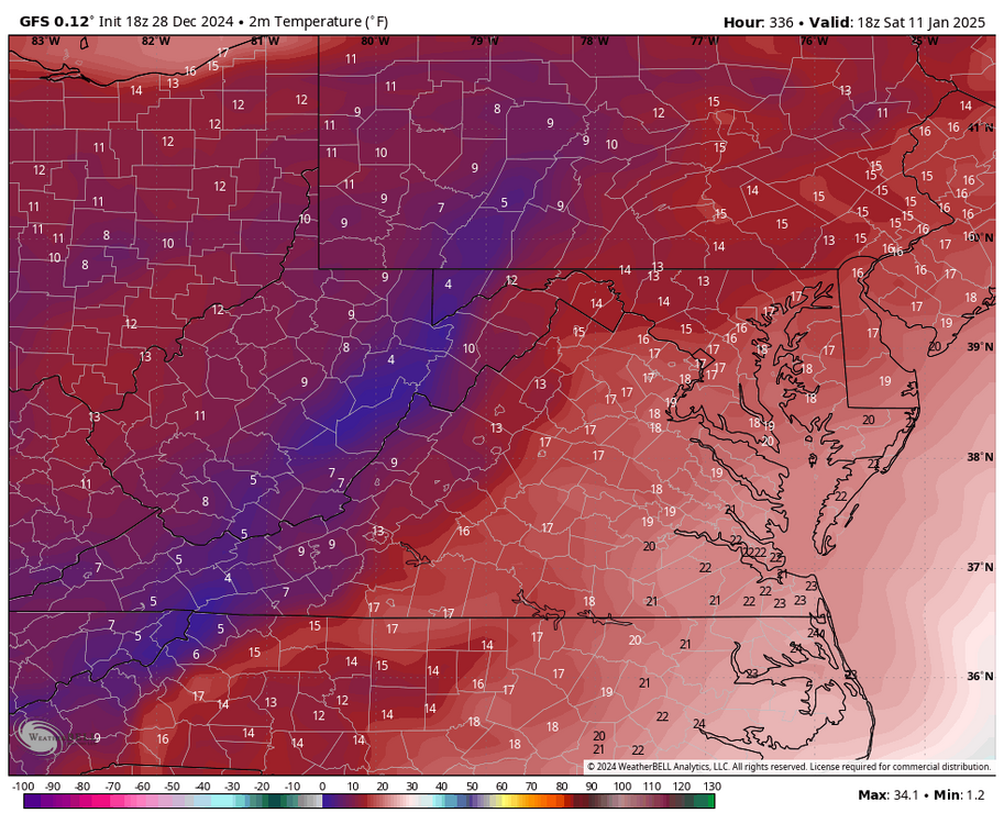
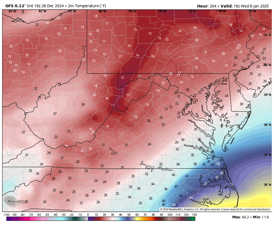
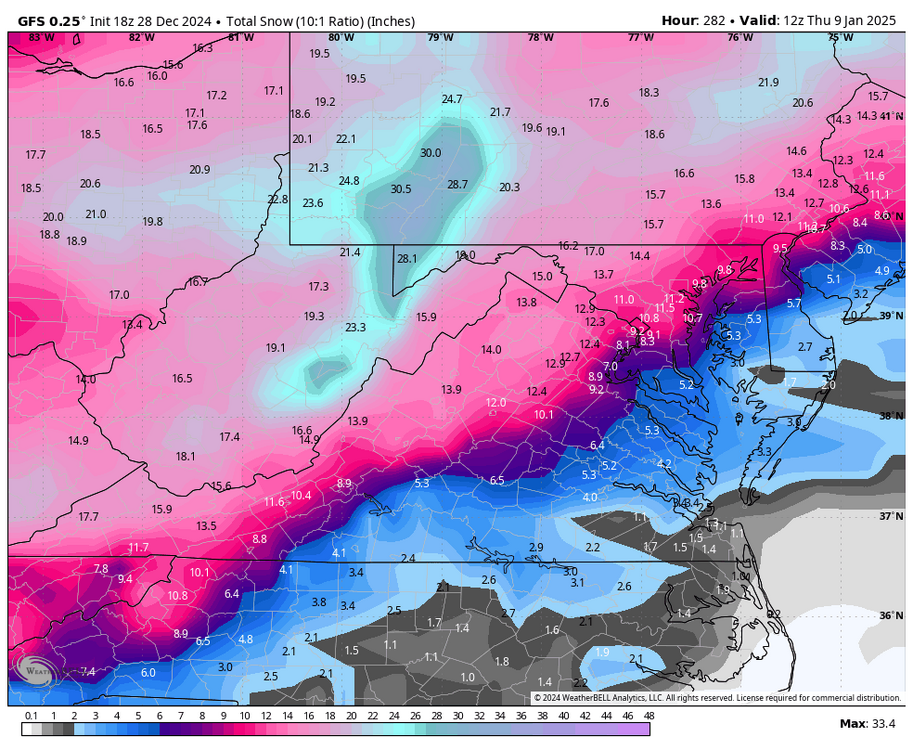
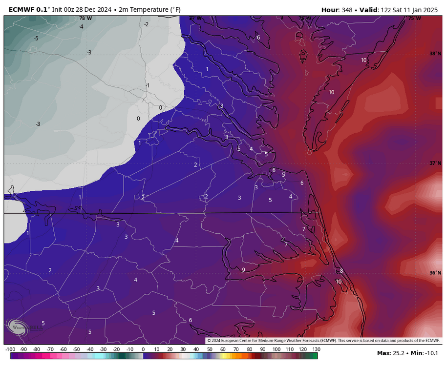
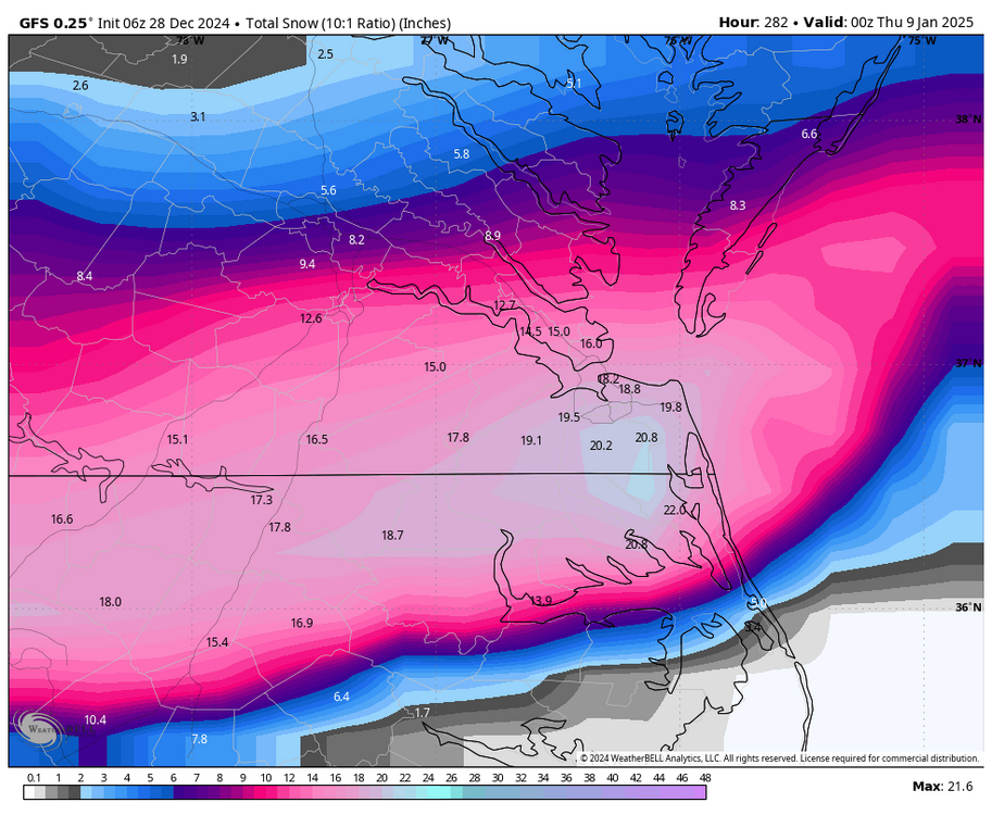
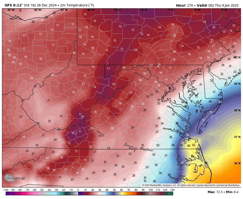
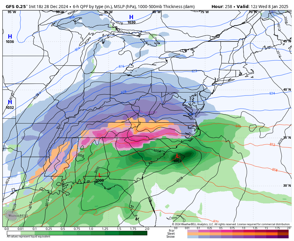
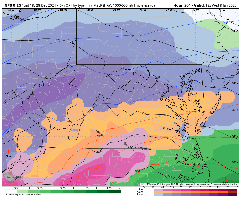
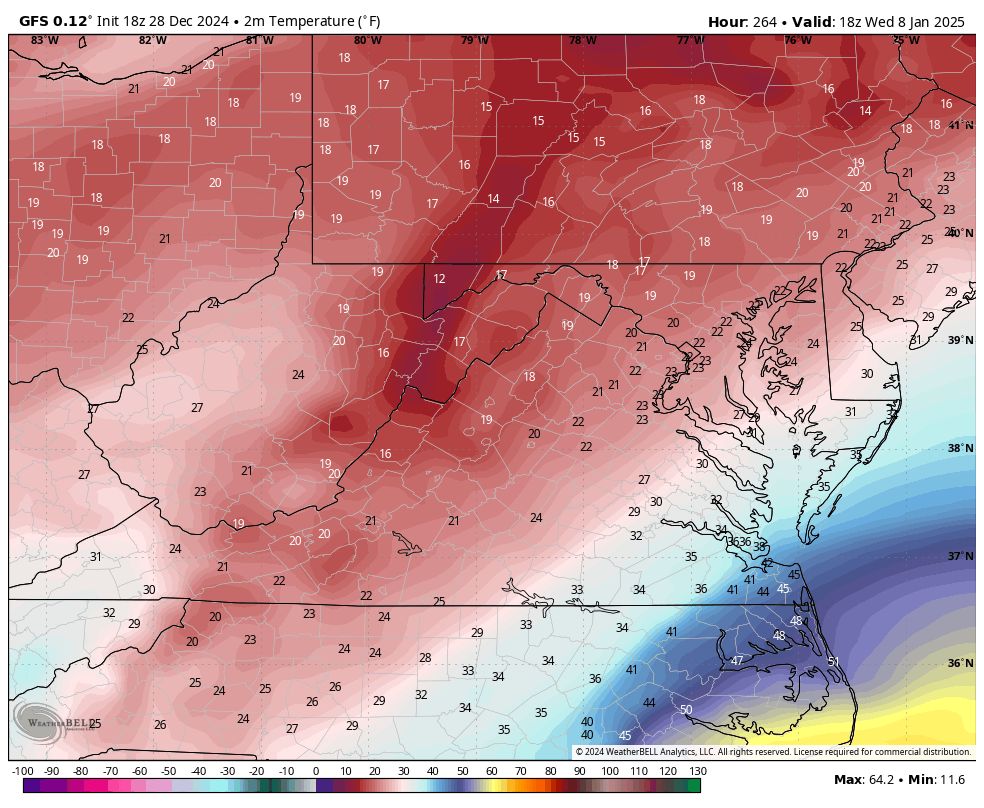
Things continue to look exciting heading into January. GFS and Euro have advertised snow to varying degrees on quite a few runs. I am just waiting for more consistency and also for us to get within seven days before I get too excited. We all remember how last year turned out. Models showed a great H5 pattern and yet we were left in disappointment. But, for now, I have muted optimism. Interestingly, the 00z Euro had a high of only 13°F at Richmond on Friday, January 10th and a low temperature of 0°F the next morning. Also, this morning's 6z GFS had a significant NC/VA snowstorm, an old-school type, on January 7-8th. The heaviest accumulations were south and east of Richmond with 18" in Norfolk. I emphasize these extremes to underscore the potential of the upcoming weather pattern. Fingers crossed!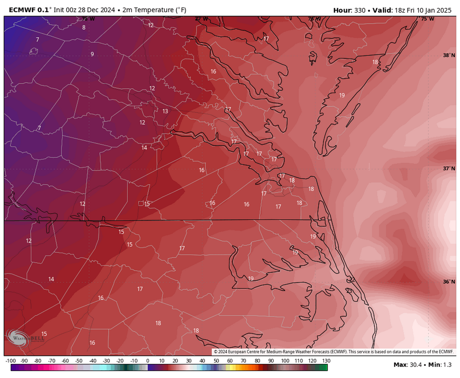
-
Richmond Metro/Hampton Roads Area Discussion
RIC Airport replied to RIC Airport's topic in Mid Atlantic
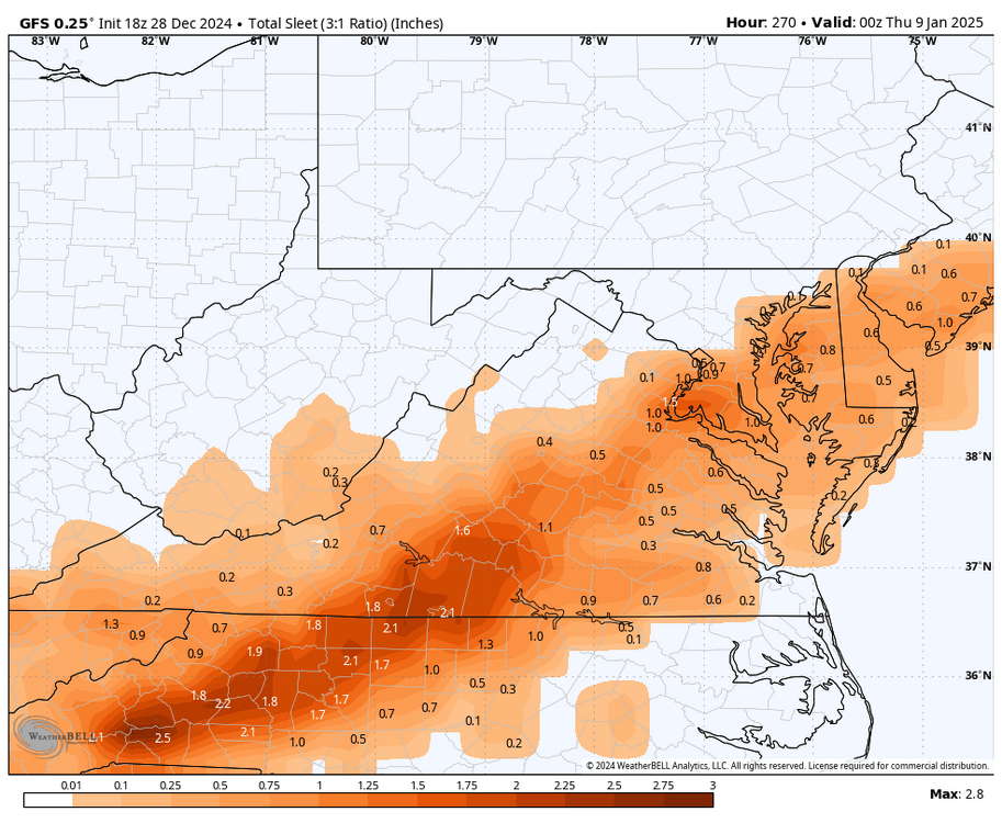
Actually, just looked at a couple panels, verbatim southside Hampton Roads would have some precip type issues. But the most of the peninsula and interior SE VA scores. -
Richmond Metro/Hampton Roads Area Discussion
RIC Airport replied to RIC Airport's topic in Mid Atlantic
Euro AI appeared to be a RIC and Hampton Roads special. Storms like 1/7/2017, 2/26/2015, 1/3/2002, 2/18/1989, and 3/1/1980 come to mind.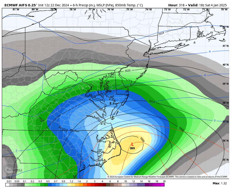
-
Richmond Metro/Hampton Roads Area Discussion
RIC Airport replied to RIC Airport's topic in Mid Atlantic
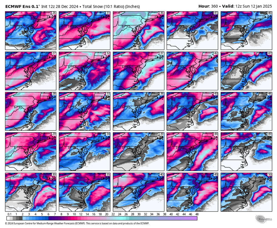
That storm on the 12z Euro would be epic!! And unlike 2016, it's an all snow event through and through for anyone west of about New Kent. Truly a beautiful evolution! It has that old school big snowstorm track that seems to be nonexistent nowadays. It also has a lot of wind, so the snow and wind combo, at least for a time, would be like 1/23/2016 or 1/25/2000 (My all time favorite ). Both storms had about a 6-8 hour period with +SN and BLSN at RIC, which is unusual. Click the link below and check out the hourly observations for the 2000 storm, things got really good after sunrise! https://weatherspark.com/h/d/147038/2000/1/25/Historical-Weather-on-Tuesday-January-25-2000-at-Richmond-International-Airport-Virginia-United-States#Figures-ColorTemperature In the 2016 storm, RIC narrowly missed reaching official blizzard criteria because, during the second of three hours, they recorded a wind gust of 32 mph instead of the 35 mph required. Seeing more signals of cold and storminess is encouraging. And like everyone else, I’m waiting to see how the rest of this winter develops, but I’m trying not to get too caught up in each model run, especially anything still over a week away with no run to run consistency. Last year was fun but exhausting, especially when we didn’t get much snow, and the 2nd half of winter ended in disappointment despite all the hype. I haven’t been posting much lately because I had surgery about about 10 days ago, and the timing of this potential storm isn't ideal for me. I’ll be dealing with post-surgical recovery until 1/13 before I’m fully mobile again. While I’ll be able to track a storm and participate here before then, I won’t be able to enjoy the event as much due to my limited mobility.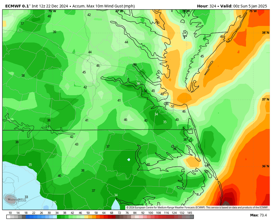
-
Richmond Metro/Hampton Roads Area Discussion
RIC Airport replied to RIC Airport's topic in Mid Atlantic
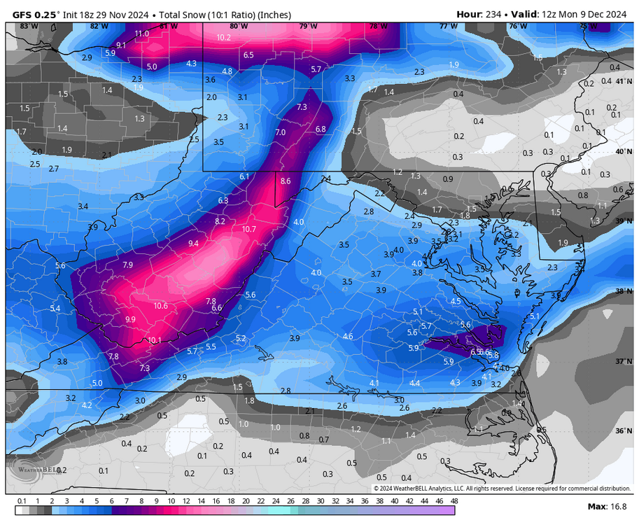
00Z GFS delivered. So much time to go.
-
Richmond Metro/Hampton Roads Area Discussion
RIC Airport replied to RIC Airport's topic in Mid Atlantic
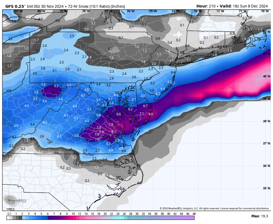
December has potential now that we're finally getting cold. 18Z GFS had a decent hit. The models have been signaling an early December storm threat off and on for days. Timing and placement have differed so something to watch.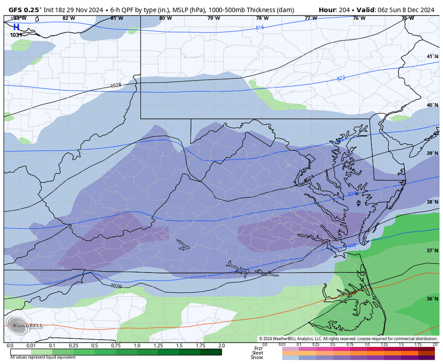
-
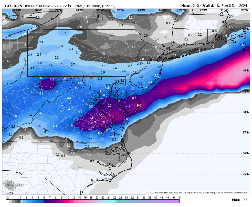
BWI: 19.6” DCA: 17.3” IAD: 24.7" RIC: 14.5” LYH: 16.9”
-
Richmond Metro/Hampton Roads Area Discussion
RIC Airport replied to RIC Airport's topic in Mid Atlantic
KRIC reached freezing for the first time this season this morning, with a low of 30°F. This means it's time to unlock this thread so let's hope winter 2024-25 proves to be more fruitful than the past few seasons. Last winter, the highest amount of snow recorded in a single day was just 0.5 inches on 1/15/24. Additionally, there was 0.2 inches measured on the morning of 12/11/23. It has now been over 1,000 days since the airport recorded an inch or more of snow. Let's hope this streak comes to an end soon.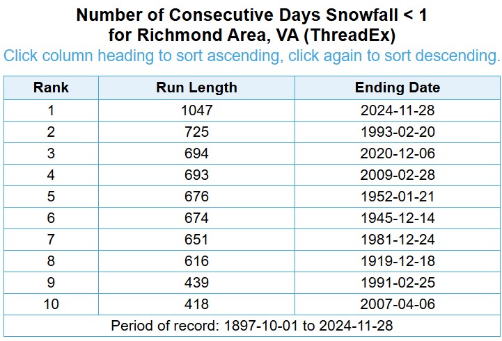
-
Richmond Metro/Hampton Roads Area Discussion
RIC Airport replied to RIC Airport's topic in Mid Atlantic
Of course 18Z GEFS took it away, but I looked at the charts for the 12z run and p25 dropped the following totals in VA, MD and NC. Virginia Wallops Island: 50" West Point: 43" Williamsburg: 40" Newport News: 40" Hampton: 40" Tappahanock: 39" Accomack: 35" Wakefield: 32" Petersburg: 30" Chesapeake: 28" Suffolk: 28" Richmond: 25" Hanover: 25" Chesterfield: 25" Norfolk: 22" Franklin: 22" Virginia Beach: 22" Maryland Salisbury: 53" Cambridge: 41" Lexington Park: 37" Ocean City: 30" Ridgely: 25" Easton: 25" Clinton: 25" North Carolina Edenton: 24" Ahoskie: 22" Elizabeth City: 10" Currituck: 10" -
Richmond Metro/Hampton Roads Area Discussion
RIC Airport replied to RIC Airport's topic in Mid Atlantic
Yeah, RIC only recorded 7.2". A pretty boring event, just very light to only occasionally moderate snow. The super cold temps are what saved it. Got another storm a week later (2/26/2015) where about 5-6" fell in only a few hours, more in the Hampton Roads area. The snow started around midnight and quickly became heavy up until it ended around 6am. Officially, 5.0" fell at RIC and 5.6" at ORF. I thought I had saved more images from that storm, it could be because I was still living in Seattle at the time, but tracked from afar..gif.1895ca260346f421fe076db48510f159.gif)

-
Richmond Metro/Hampton Roads Area Discussion
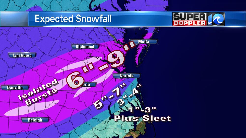
RIC Airport replied to RIC Airport's topic in Mid Atlantic
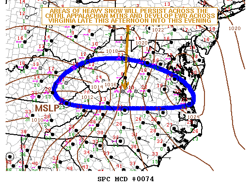
@JFLETCHER, This is from the snowstorm on February 16-17, 2015. It was a very cold snowstorm for all of Virginia, one of the coldest snowstorms, at least in my lifetime, and one of the rare occasions where the entire state was under a winter storm warning. RIC was in the low to mid-teens for most of the snowstorm. Hoping to see something like this again.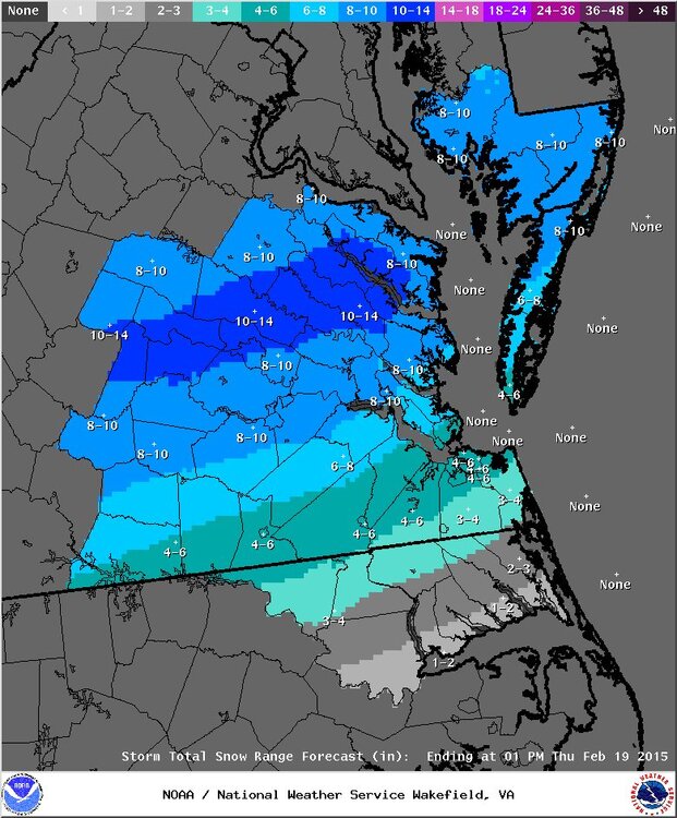
.png.b82f6bba6ccb9444305a97aaae60a299.png)
.thumb.jpg.806e1b766a66e44c15e5e42e13661b5c.jpg)
-
Richmond Metro/Hampton Roads Area Discussion
RIC Airport replied to RIC Airport's topic in Mid Atlantic
It's sad, but winters like this one and last year are becoming more routine. We will still get cold and snow (maybe even a HECS occasionally) with the right pattern and timing, but it will become more challenging, and cold will be more limited in intensity and duration. Winters in Richmond and the mid-Atlantic overall have declined since about 1990. Our oceans are torching, which is part of the problem. -
Richmond Metro/Hampton Roads Area Discussion
RIC Airport replied to RIC Airport's topic in Mid Atlantic
The most QPF I saw was maybe 0.60" on ONE of the runs about 24 hours or so out. Most amounts were in the 0.20 to 0.40" range, and the coldest temp I noticed on the models around DCA was 32°F-33°F. And it was always supposed to be a rain-to-snow situation with temps dropping from the mid and upper 30s, which causes you to lose QPF. Given the marginal temps and limited QPF, I don't understand why up to 3-5" was even in the forecast anywhere nearby. @Stormpcno, but I was up for the bust to see the weenie tears. When DCA was still 40°F at 1am, I knew it was over. Even at 1am, the forecast still called for "heavy snow" and 2-4" (see below). They ended up recording 0.1" of snow and only .10" of QPF.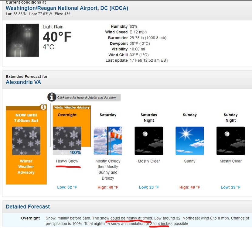
-
Richmond Metro/Hampton Roads Area Discussion
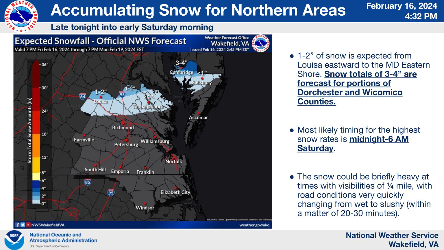
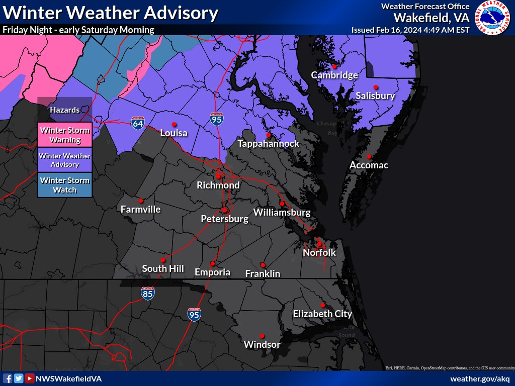
RIC Airport replied to RIC Airport's topic in Mid Atlantic
Wakefield is still pretty bullish for @JFLETCHER's area and toward the Northern Neck. URGENT - WINTER WEATHER MESSAGE National Weather Service Wakefield VA 319 PM EST Fri Feb 16 2024 VAZ064-075-076-509>511-521-170430- /O.CON.KAKQ.WW.Y.0004.240217T0300Z-240217T1200Z/ Caroline-Westmoreland-Richmond-Western Louisa-Eastern Louisa- Western Hanover-Western Essex- Including the cities of Corbin, Burruss Corner, Cedar Fork, Dawn, Sandy Point, Westmoreland, Colonial Beach, Leedstown, Oak Grove, Potomac Beach, Potomac Mills, Naylors Beach, Downing, Emmerton, Ethel, Farnham, Haynesville, Kennard, Louisa, Mineral, Ashland, and Tappahannock 319 PM EST Fri Feb 16 2024 ...WINTER WEATHER ADVISORY REMAINS IN EFFECT FROM 10 PM THIS EVENING TO 7 AM EST SATURDAY... * WHAT...Snow expected. Total snow accumulations of 1 to 2 inches. * WHERE...Portions of central, east central and north central Virginia. * WHEN...From 10 PM this evening to 7 AM EST Saturday. * IMPACTS...Plan on slippery road conditions. PRECAUTIONARY/PREPAREDNESS ACTIONS... Slow down and use caution while traveling. For the latest road conditions in Virginia or Maryland, please call 5 1 1. For the latest road information in North Carolina, go to http://DriveNC.gov.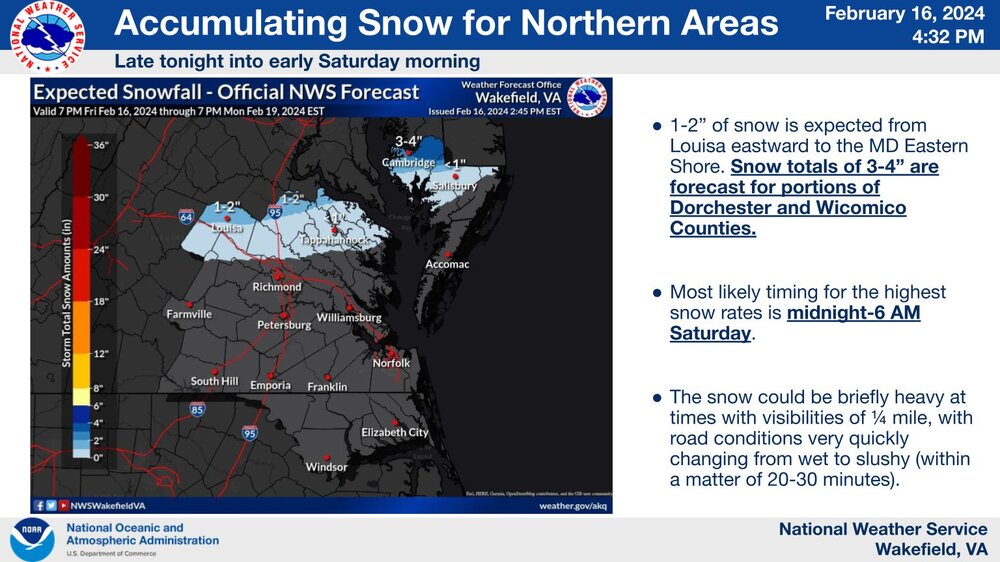


.png.22dc771d7253e577c52693c6edc16739.png)


.jpg.dfaa4a5a20396f049a9603b1530c3082.jpg)