

Random Chaos
-
Posts
751 -
Joined
-
Last visited
Content Type
Profiles
Blogs
Forums
American Weather
Media Demo
Store
Gallery
Posts posted by Random Chaos
-
-
1 hour ago, Volcanic Winter said:
Tallis, I recognize you from Volcanocafe! Nice to see you here man.
And yes, this eruption did appear to be large enough to enact measurable climate forcings but we need more data on the overall volume and amount of SO2 injection.
Also, outside of very, very large eruptions (7+?), aren’t the climate forcings from large plinian eruptions usually restricted to the hemisphere they occurred in (aka Southern)?
Volcano Cafe is great! Always read it after an event, mostly lurker there but occasionally post. Got me to check my weather station for the shockwave:
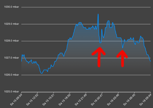
-
Some incredible statistics about the Tonga eruption here - including record cold temperature detected by a satellite and over 400k lightening strikes in just a few hours:
https://cimss.ssec.wisc.edu/satellite-blog/
(unfortunately no direct article link available, it’s the post on Jan 15th)
And here are some other great satellite views of the eruption:
-
 1
1
-
-
25.6/8.2
10-15mph wind N to NNE
Near Annapolis.
-
16 minutes ago, EastCoast NPZ said:
Yes. Wind would mix the surface inversion, scouring out the low level cold . I don't buy any depiction showing a windy freezing rain scenario.
I’m not sure that’s quite what is depicted. The wind doesn’t really pick up on the NAM until after the rain transition on the model. That ZR is almost entirely before the big rain mass reaches us. If you look at the 850 winds at 0z Monday on the 12z NAM, the mass of wind has just reached DC and already the ZR has pulled north of DC.
-
1
-
-
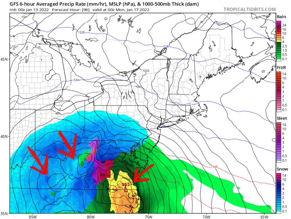
Looks to me the biggest problem with the models is consolidating the low pressure in a single location. The GFS is jumping back and forth between 2 of these lows, and that seems to be what is making the sudden west jog jyst before it hits us:
-
2
-
-
I’m thinking of the storm a week ago. The GFS had it a week ahead, then lost it, only to get it back 2 days ahead, then stuck verbatim and we got a good storm. Next few days could be rough but lets not write this thing off from run to run oscillation. There’s definitely something going on with the op vs ensembles but no clue what. Remember thst data for this storm is originating out over the pacific now - mostly satellite derived data which is less accurate than ground stations.
-
13 minutes ago, Bob Chill said:
Maybe I'll just do what it says to do on page 3 of the weenie handbook and hug the snowiest model and toss everything else. We're on a heater anyways.

That’s my usual process

-
12 minutes ago, DDweatherman said:
I can't answer to the first part, but because of higher resolution, the permutations these models identify and go in depth on have a greater downstream influence sooner in the run because of their resolution. Obviously, if that happens based on a feature 60 hours into a run, the downstream impact on big picture evolution is further magnified versus a run at lower res.
That’s exactly what I was thinking, just wondering if there was a study on it. Not talking verification scores so much as how these permutations are amplified. The raw data ingested is not exact, especially data that originated west of California, and errors or inaccuracies in the data could be amplified in the 5+ day period for us on the east coast in higher resolution models.
-
I wonder, have there been any studies on the accuracy of a model at medium to long range when run at different resolutions? It seems to me that both the Euro and GFS were better at the 5+ day range (more consistent run-to-run) back before the resolution upgrades that started a number of years back. I’m bringing this up because the EPS and GEFS are run at lower resolution and both have eastern tracks vs the op. Wondering if errors are getting amplified at range with these higher resolution models.
-
1
-
-
17 minutes ago, NorthArlington101 said:
I bet you care about this one too, and it is… surprisingly not that notable?
I’ll take P15.
-
1
-
 1
1
-
-
9 minutes ago, clskinsfan said:
OK. That is the first time in my life I have seen a car standing straight up in a snow bank. Hilarious.
Clearly you need to drive more around the DC area after a storm

-
 1
1
-
-
Just now, jayyy said:
Is this BWI?
Sorry, yes, bwi:
https://meteor.geol.iastate.edu/~ckarsten/cobb/cobb.php?model=namm&site=kbwi
-
1
-
-
I’ll take the COBB output!
NAM 18z:
220107/0700Z  13  35007KT  30.5F  SNOW    9:1| 0.1|| 0.00|| 0.00|| 0.009    9:1|  0.1|| 0.00|| 0.00|| 0.01  100|  0|  0
220107/0800Z  14  32009KT  30.5F  SNOW   20:1| 2.4|| 0.00|| 0.00|| 0.120   19:1|  2.5|| 0.00|| 0.00|| 0.13  100|  0|  0
220107/0900Z  15  32008KT  30.5F  SNOW   27:1| 1.8|| 0.00|| 0.00|| 0.066   22:1|  4.2|| 0.00|| 0.00|| 0.20  100|  0|  0
220107/1000Z  16  32009KT  30.3F  SNOW   20:1| 0.8|| 0.00|| 0.00|| 0.041   21:1|  5.1|| 0.00|| 0.00|| 0.24  100|  0|  0
220107/1100Z  17  31010KT  30.1F  SNOW    9:1| 0.1|| 0.00|| 0.00|| 0.006   21:1|  5.1|| 0.00|| 0.00|| 0.24  100|  0|  0
27:1 ratios, here we come!
-
1
-
1
-
-
I’m hanging my hope on insane ratios to turn that turd of a GFS run into a crushing blow!

-
1
-
-
RGEM keeps hope alive!
-
Saw this on WTOP: Eastbound U.S. 50 before I-97 is closed. One lane is open westbound. Tractor-trailers have jackknifed.
-
 1
1
-
-
Wind driven wet snow has given me 2" on vertical surfaces on the windward side of posts, while the ground has maybe half an inch total.
-
1
-
-
US 50 in Annapolis down to one track through snow: https://chart.maryland.gov/video/video.php?feed=7e01ec5800f700d700437a45351f0214
-
1
-
-
34.4/33.1
Temperatures finally caving to the snow rate in last 30 minutes. White coating on everything now.
-
Looking at traffic cams, US 50 in Annapolis now snow covered.
-
36.3/34.7 - 100 feet offshore / 120 feet from house
33/?? - at house
That’s an incredible 3F delta in 120 feet! Chesapeake Bay is still very warm, but rates overcoming temps and starting to see sticking.
-
36.3/34.5
25mph NNE wind
SN+ big fat flakes going completely sideways.
Nothing sticking yet.
-
43.8/37.4
Winds 18mph NNE
Note that the dips in temperature earlier were wind direction changes between off-land and off-Chesapeake Bay.
-
Why are we not in storm mode? As funny as it is, this banter is getting distracting.
-
 3
3
-
1
-

January 16-17, 2022 MLK storm obs/now cast
in Mid Atlantic
Posted
Here we go!