

Random Chaos
-
Posts
876 -
Joined
-
Last visited
Content Type
Profiles
Blogs
Forums
American Weather
Media Demo
Store
Gallery
Posts posted by Random Chaos
-
-
Definitely feel it should be warned. It’s heading straight for me, should be able to say in 15-20 minutes…
-
Meso discussion just out on that Tornado:
QuoteMesoscale Discussion 0204 NWS Storm Prediction Center Norman OK 1251 PM CDT Sat Mar 15 2025 Areas affected...South-central Mississippi Concerning...Tornado Watch 45... Valid 151751Z - 151845Z The severe weather threat for Tornado Watch 45 continues. SUMMARY...An intense to potentially violent tornado is ongoing across Waltha County, MS and is expected to continue northeast. DISCUSSION...WSR-88D Data out of KHDC shows a rapidly intensifying tornadic circulation with radar derived rotation of 60+ knots (briefly over 90 knots) and a tornado debris signature over 25kft. This suggests an intense to violent tornado is ongoing. This storm is located in the centroid of the maximum STP of 6-8 from SPC Mesoanalysis. This storm will likely be unimpeded as it moves northeast through the afternoon. Therefore, this tornado may persist for quite awhile at intense to violent intensity. ..Bentley.. 03/15/2025 ...Please see www.spc.noaa.gov for graphic product... ATTN...WFO...JAN...LIX... LAT...LON 31798943 31718926 31528926 31378945 31148984 31079028 31289032 31519015 31718995 31788975 31798943
-
Fire weather watch just popped:
URGENT - FIRE WEATHER MESSAGE
National Weather Service Baltimore MD/Washington DC
213 PM EST Fri Feb 28 2025


DCZ001-MDZ004>006-008-011-013-014-503>508-VAZ053-054-505-506-
010315-
/O.NEW.KLWX.FW.A.0001.250301T1600Z-250302T0100Z/
District of Columbia-Frederick MD-Carroll-Northern Baltimore-
Cecil-Southern Baltimore-Prince Georges-Anne Arundel-
Northwest Montgomery-Central and Southeast Montgomery-
Northwest Howard-Central and Southeast Howard-Northwest Harford-
Southeast Harford-Fairfax-Arlington/Falls Church/Alexandria-
Western Loudoun-Eastern Loudoun-
213 PM EST Fri Feb 28 2025

...FIRE WEATHER WATCH IN EFFECT FROM SATURDAY MORNING THROUGH
SATURDAY EVENING FOR STRONG WINDS AND LOW RELATIVE HUMIDITY FOR
NORTH CENTRAL AND NORTHEAST MARYLAND...THE DISTRICT OF COLUMBIA
AND NORTHERN VIRGINIA...

The National Weather Service in Baltimore MD/Washington has
issued a Fire Weather Watch for strong winds and low relative
humidity, which is in effect from Saturday morning through
Saturday evening.

* TIMING...From Saturday morning through Saturday evening.

* WINDS...Northwest 20 to 25 mph with gusts up to 45 mph.

* RELATIVE HUMIDITY...As low as 19 percent.

* IMPACTS...The combination of dry conditions, low humidity, and
  strong gusty winds may result in favorable conditions for the
  rapid spread of fires

* FUEL MOISTURE...5 to 10 percent.

PRECAUTIONARY/PREPAREDNESS ACTIONS...

A Fire Weather Watch means that critical fire weather conditions
may occur. Listen for later forecasts and possible Red Flag
Warnings.

&&

$$

http://www.weather.gov/lwx/fire
-
Some people are upset at the NWS firings being discussed here, but the people affected are some of those on this board we always await with glee their forecast comments, some of the red-tagged meteorologists who give us the best analysis of the next winter storm or summer squall line. Whether or not people here got fired in this first wave, they likely knew people that did, and they could be fired in the next wave or the one after that. These are our friends.
I hate that politics has come to a weather forum, but it was pushed on us from the outside, not something we chose or desired.
-
 1
1
-
-
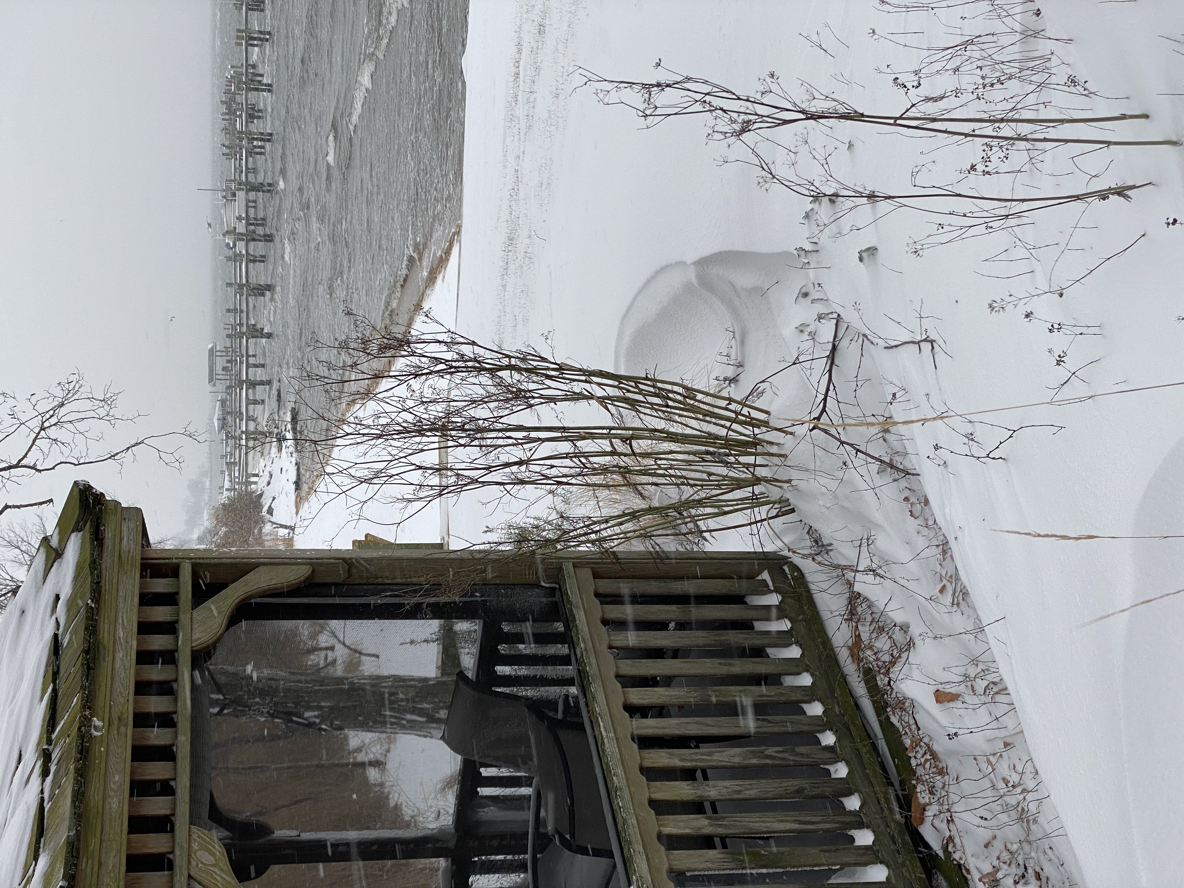
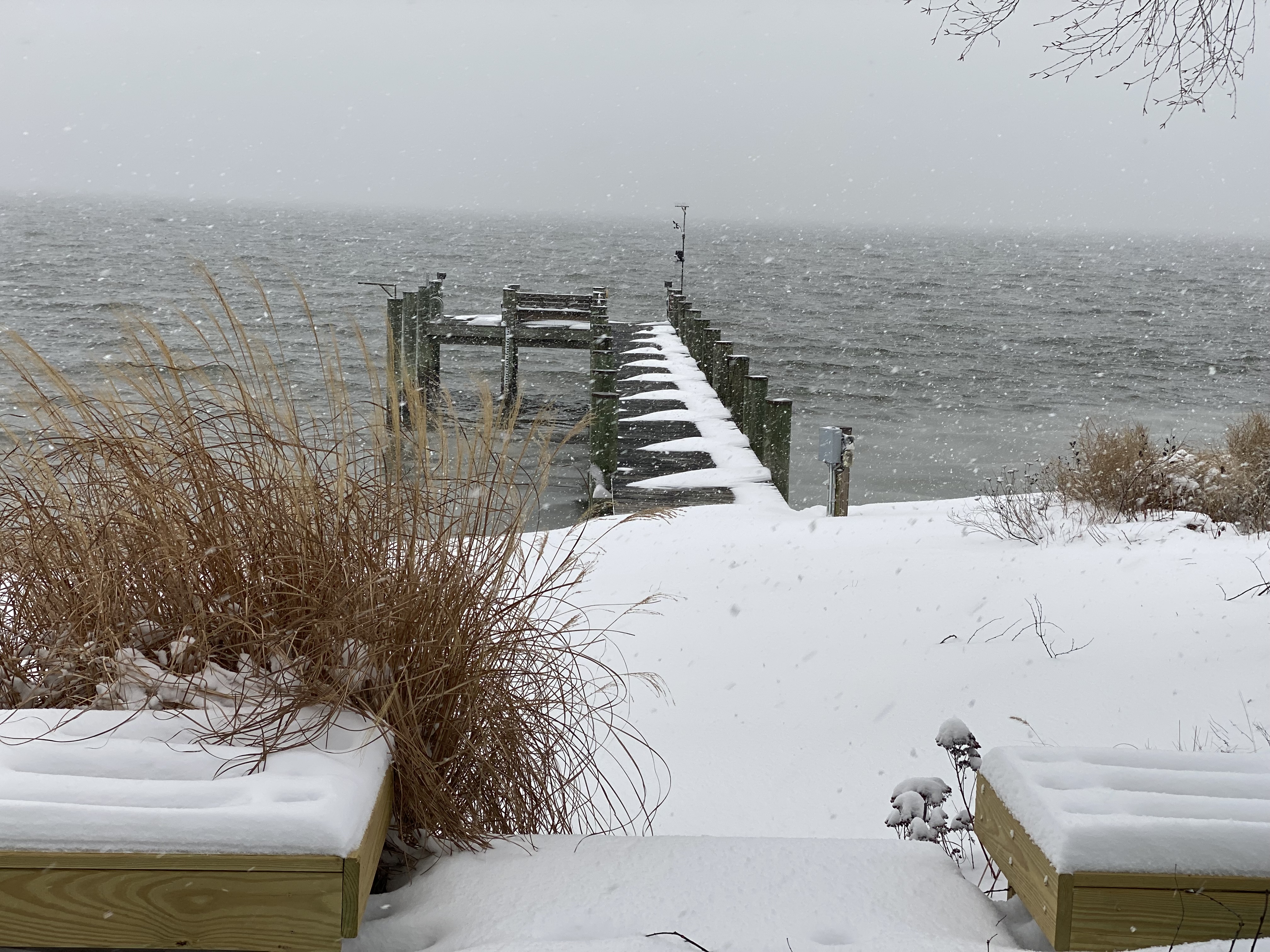
Hit a 50mph wind gust not long ago. Bay bridge is closed due to winds over 55mph.
-
5 minutes ago, MDScienceTeacher said:
Other than the ICON, if this verifies than it is a total and complete fail. Two days ago, we had every single model in our camp except for the GFS. and several people said said that there is no way in hell every model would cave to the GFS.. and here we fucking are. I cant believe what I am seeing.. how could this happen again?
It’s only a fail if you look at "snow in my back yard" measure. If anything this is a huge sucess for the models. We’ve seen remarkable consistency from 6 days out to 4 days out with only minor track changes, but because of the range minor changes result in significant differences in who gets snow and who doesn’t. We’ve been consistently seeing a southern eastern shore/Ocean City axis with models frequently, but not always extending the precip shield over the DC metro. We’ve consistently seen a coastal bomb cyclone but differences in exactly where the northern turn occurs that impact totals here but not Ocean City. We always sit on a razors edge here for max potential, and the models have been crazy consistent in that there is a storm to within a very small north/south zone at very good temporal range.
-
2
-
-
1 minute ago, WVsnowlover said:
50" totals in upstate NY lol
.thumb.png.142042860796e27647bd9c66218556db.png)
That includes today’s snow.
-
1
-
-
32 minutes ago, Ji said:
I think most agree that anything under
1020 now would be heartbreakingFixed it for you.
-
I think I’m going to make a new model and call it the Ji model. It will take the output from all the other major models, average them, then remove all snow in a 25 mile radius around Ji’s house.
-
1
-
 1
1
-
 1
1
-
-
Every. Major. Model.

-
2
-
-
New advisory up, haven’t seen this one before that I recall:
Freezing Spray Advisory
URGENT - MARINE WEATHER MESSAGE
National Weather Service Baltimore MD/Washington DC
312 PM EST Sun Jan 19 2025

ANZ531>534-537-539>541-543-200415-
/O.CON.KLWX.SC.Y.0013.000000T0000Z-250120T2300Z/
/O.NEW.KLWX.UP.Y.0001.250120T0500Z-250120T2300Z/
Chesapeake Bay from Pooles Island to Sandy Point MD-
Chesapeake Bay from Sandy Point to North Beach MD-
Chesapeake Bay from North Beach to Drum Point MD-
Chesapeake Bay from Drum Point MD to Smith Point VA-
Tidal Potomac from Cobb Island MD to Smith Point VA-
Chester River to Queenstown MD-Eastern Bay-
Choptank River to Cambridge MD and the Little Choptank River-
Tangier Sound and the inland waters surrounding Bloodsworth
Island-
312 PM EST Sun Jan 19 2025

...SMALL CRAFT ADVISORY REMAINS IN EFFECT UNTIL 6 PM EST MONDAY...
...FREEZING SPRAY ADVISORY IN EFFECT FROM MIDNIGHT TONIGHT TO
6 PM EST MONDAY...

* WHAT...For the Small Craft Advisory, northwest winds 15 to 25
  kt with gusts up to 30 kt and waves 2 to 4 ft. For the
  Freezing Spray Advisory, moderate accumulation of freezing
  spray expected.

* WHERE...Chesapeake Bay from Pooles Island MD to Smith Point
  VA, Tidal Potomac from Cobb Island MD to Smith Point VA,
  Chester River to Queenstown MD, Eastern Bay, Choptank River to
  Cambridge MD and the Little Choptank River, and Tangier Sound
  and the inland waters surrounding Bloodsworth Island.

* WHEN...For the Small Craft Advisory, until 6 PM EST Monday.
  For the Freezing Spray Advisory, from midnight tonight to 6 PM
  EST Monday.

* IMPACTS...Operating a vessel in freezing spray is hazardous.
  Freezing spray may render mechanical and electronic components
  inoperative. Ice accretion on decks and superstructures may
  result in some loss of stability. Conditions will be hazardous
  to small craft.

PRECAUTIONARY/PREPAREDNESS ACTIONS...

Mariners should prepare for ice accumulation on their vessel and
consider altering plans to avoid or mitigate these hazardous
conditions.

Inexperienced mariners, especially those operating smaller
vessels, should avoid navigating in hazardous conditions.
-
37.3F, SN, accumulating
Ground must be colder than the air.
-
It’s less than the 43" given to me yesterday. Toss.
-
5
-
-
7" in fairly undrifted area. Measured drifts up to 21".
-
13
-
-
Been some nice steady snow for the last 2 hours. Not a ton of accumulation from in, maybe an inch. So hard to tell with the drifting I get.
-
Comparing the H5 vorticity to past runs, very similar to 18z yesterday.
-
5 minutes ago, jayyy said:
Did you scroll up? GFS showed 12+” last night lolAnd 43" on the run before that. If only lol.
-
1
-
1
-
-
Puking snow here in Annapolis:
-
15
-
-
I finally got outside to measure. I have a modest amount of drifting so had to walk to where I was both out of the wind and out of drifted snow. Measured 6" there. Rest of the area measured 0 to 8" depending on drifting. My deck is bare in places from the light wind removing the snow.
-
Eyeball estimate of 2" on my deck. Haven’t gone outside to measure yet. Heavy SN+.
-
1 minute ago, paulythegun said:
DC downgraded to Winter Weather Advisory?
Only the 5 foot radius around the DCA snow board. Rest of the city still getting 8+.
-
2
-
-
SN- where I am near Annapolis. Just started.
-
2 minutes ago, SnowenOutThere said:
Just wondering if this apparent dry area on radar is actually real or just the result of the radar. I’m aware there’s sometimes some issues looking southwest from sterling
Look at KDOX radar. It’s because of beam altitude. Snow is falling but not reaching the ground. So the closer to the radar you lose returns.
-
2
-
-
33.5/15.9 near Sandy Point State Park, station is affected by the warm bay so expect it to drop once snow starts.
-
3
-
.png.2171b98a507b4dc88c3d6ef296ec397c.png)
2025 Severe Weather General Discussion
in Mid Atlantic
Posted
Just heavy rain, not even strong winds. Lots of lightning though.