

Random Chaos
-
Posts
751 -
Joined
-
Last visited
Content Type
Profiles
Blogs
Forums
American Weather
Media Demo
Store
Gallery
Posts posted by Random Chaos
-
-
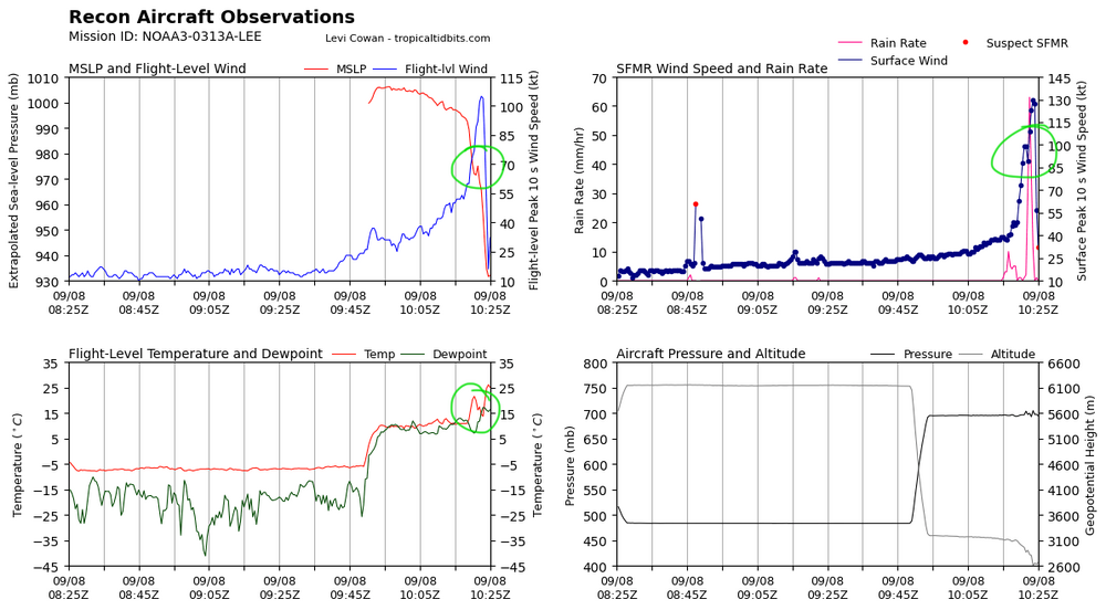
Indications of a double maxima on recon, but it’s subtle. Probably the start of an ERC and if so likely the cause of the degraded appearance on satellite this morning:
-
 1
1
-
-
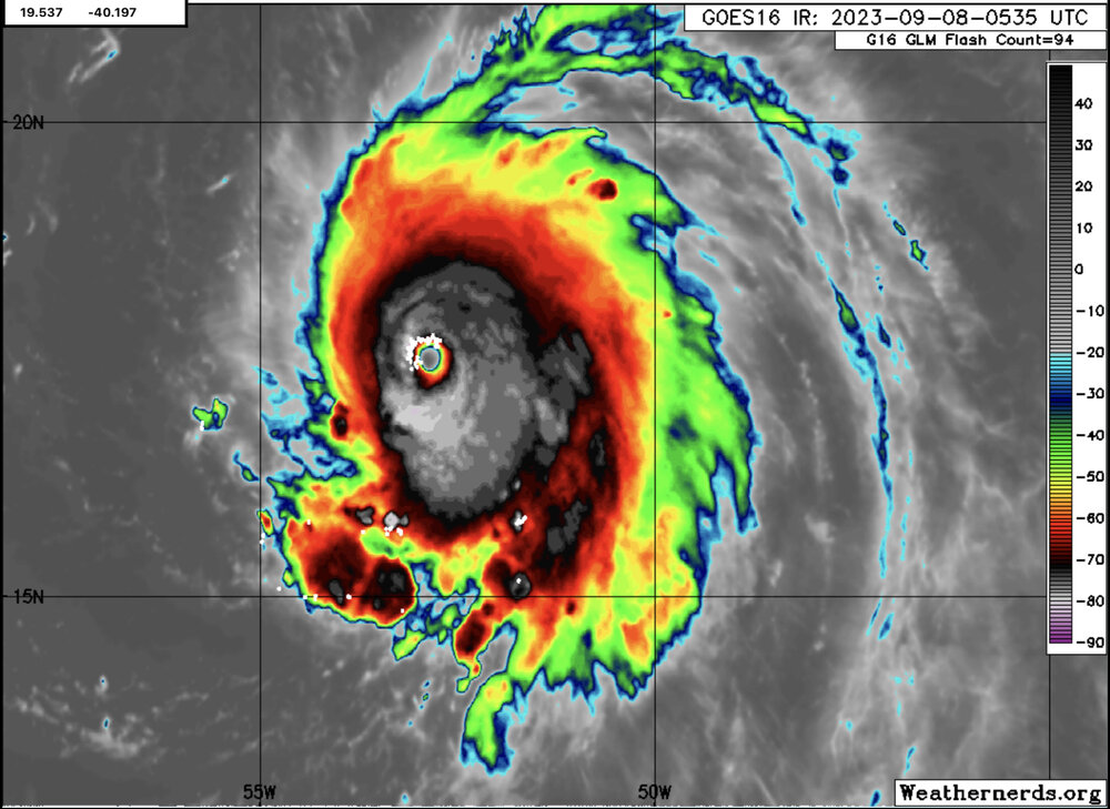
I hope that recon gets there soon. Eye has filled in and is occluded, but lightening is going insane (have a 80-150 strokes per 10 minutes the past 2 hours!). I think it might be an ERC but the latest microwave pass was too long ago (2.5 hours). I’m basing this on the eye becoming a pinhole just before vanishing plus IR looking like a second maximum cold ring is now appearing about 15-20nm radius. If so this might be the fastest nothing to ERC I’ve ever heard of (normally they take 12-24 hrs).
-
Interesting (not based on the most recent VDM):
-
3
-
-
We are continuing to see large quantities of lightning in the eyewall, been continuous for the past 9 hours with the number of strikes increasing in the past 1-2 hours. Seen several 90+ strikes per 10 minutes in the past hour.
-
4
-
-
New VORTEX message.
Couple notes:- 28C eye temperature.
- 14nm circular eye, 1nm less than last recon
- 158kt SFMR
—————
Product: Air Force Vortex Message (URNT12 KNHC)
Transmitted: 8th day of the month at 5:26Z
Agency: United States Air Force
Aircraft: Lockheed WC-130J Hercules with reg. number AF97-5306
Storm Name: Lee
Storm Number & Year: 13 in 2023 (flight in the North Atlantic basin)
Mission Number: 2
Observation Number: 28
A. Time of Center Fix: 8th day of the month at 4:54:40Z
B. Center Fix Coordinates: 17.40N 52.87W (View map)
B. Center Fix Location: 538 statute miles (866 km) to the ENE (57°) from Bridgetown, Barbados.
C. Minimum Height at Standard Level: 2,508m (8,228ft) at 700mb
D. Minimum Sea Level Pressure: 928mb (27.41 inHg)
E. Dropsonde Surface Wind at Center: From 330° at 20kts (From the NNW at 23mph)
F. Eye Character: Closed
G. Eye Shape & Diameter: Circular with a diameter of 14 nautical miles (16 statute miles)
H. Estimated (by SFMR or visually) Maximum Surface Wind Inbound: 124kts (142.7mph)
I. Location & Time of the Estimated Maximum Surface Wind Inbound: 10 nautical miles (12 statute miles) to the SE (137°) of center fix at 4:51:30Z
J. Maximum Flight Level Wind Inbound: From 228° at 131kts (From the SW at 150.8mph)
K. Location & Time of the Maximum Flight Level Wind Inbound: 11 nautical miles (13 statute miles) to the SE (138°) of center fix at 4:51:00Z
L. Estimated (by SFMR or visually) Maximum Surface Wind Outbound: 158kts (181.8mph)
M. Location & Time of the Estimated Maximum Surface Wind Outbound: 8 nautical miles to the NNW (334°) of center fix at 4:59:00Z
N. Maximum Flight Level Wind Outbound: From 62° at 153kts (From the ENE at 176.1mph)
O. Location & Time of the Maximum Flight Level Wind Outbound: 9 nautical miles to the NNW (330°) of center fix at 4:59:30Z
P. Maximum Flight Level Temp & Pressure Altitude Outside Eye: 13°C (55°F) at a pressure alt. of 3,056m (10,026ft)
Q. Maximum Flight Level Temp & Pressure Altitude Inside Eye: 28°C (82°F) at a pressure alt. of 3,038m (9,967ft)
R. Dewpoint Temp (collected at same location as temp inside eye): -1°C (30°F)
R. Sea Surface Temp (collected at same location as temp inside eye): Not Available
S. Fix Determined By: Penetration, Radar, Wind, Pressure and Temperature
S. Fix Level: 700mb
T. Navigational Fix Accuracy: 0.02 nautical miles
T. Meteorological Accuracy: 1 nautical mile
Remarks Section:
Maximum Flight Level Wind: 153kts (~ 176.1mph) which was observed 9 nautical miles to the NNW (330°) from the flight level center at 4:59:30Z -
045900 1732N 05255W 6936 02699 //// +109 //// 067132 144 158 027 01
045930 1733N 05257W 6969 02774 //// +079 //// 062148 153 153 055 01
153 and 158kt SFMR unflagged, NW quadrant.
-
 1
1
-
-
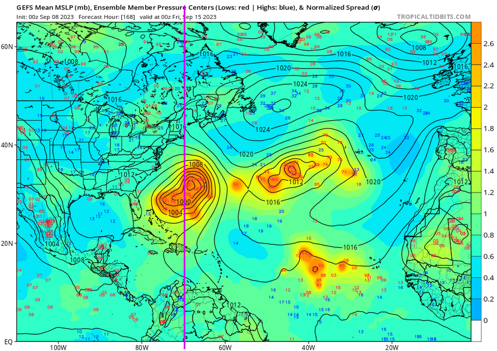
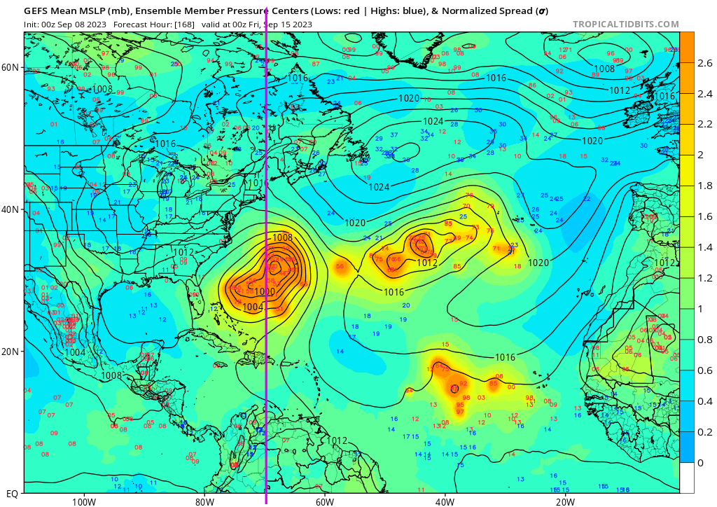
Everyone keeps talking about 70W. Well, here’s tonight’s GEFS run at hr 168. Never assume something is impossible with tropical cyclones when it’s more than 3 days out.
-
6
-
-
Interesting to note per bending before 70W is that the stronger the storm on the model (specifically hurricane models) the further south the storm stays through the 120hr period. I think it is too soon to say where the recurve happens. Both HAFS-A and HAFS-B are taking the storm due west at 120hr between 23N and 23.5N, while global models such as GFS have already started recurve and are up at 24N heading NW rather than due west. HMON and HREF that don’t strengthen the storm as much are closer to GFS. Also note none of these models predicted current strength at this point - we are 12hrs early on HAFS and HMON never even got this strong.
Also want to ask: what winter storm is predicted on the GFS at day 5 accurately? That’s essentially what we are trying to do with that ridge weakness to turn the storm north. It’s far, far too early to have any faith in a solution. 3 days for tropical systems is about the max you can reliably forecast under best case scenarios.
-
3
-
2
-
-
Play-by-play: Latest GFS run has ticked slightly south at hr 138.
Commentary: remember the early model runs of Maria took her into the Chesapeake Bay? Completely missed way south ended up recurving into the backside of Florida. So long range is almost useless to hang onto
")
edit: this is my post # 666. Wonder if that bodes ill?
-
1
-
 1
1
-
-
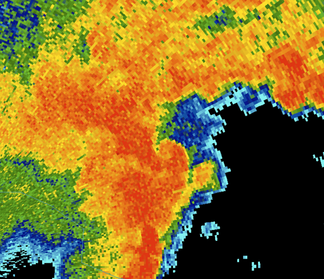
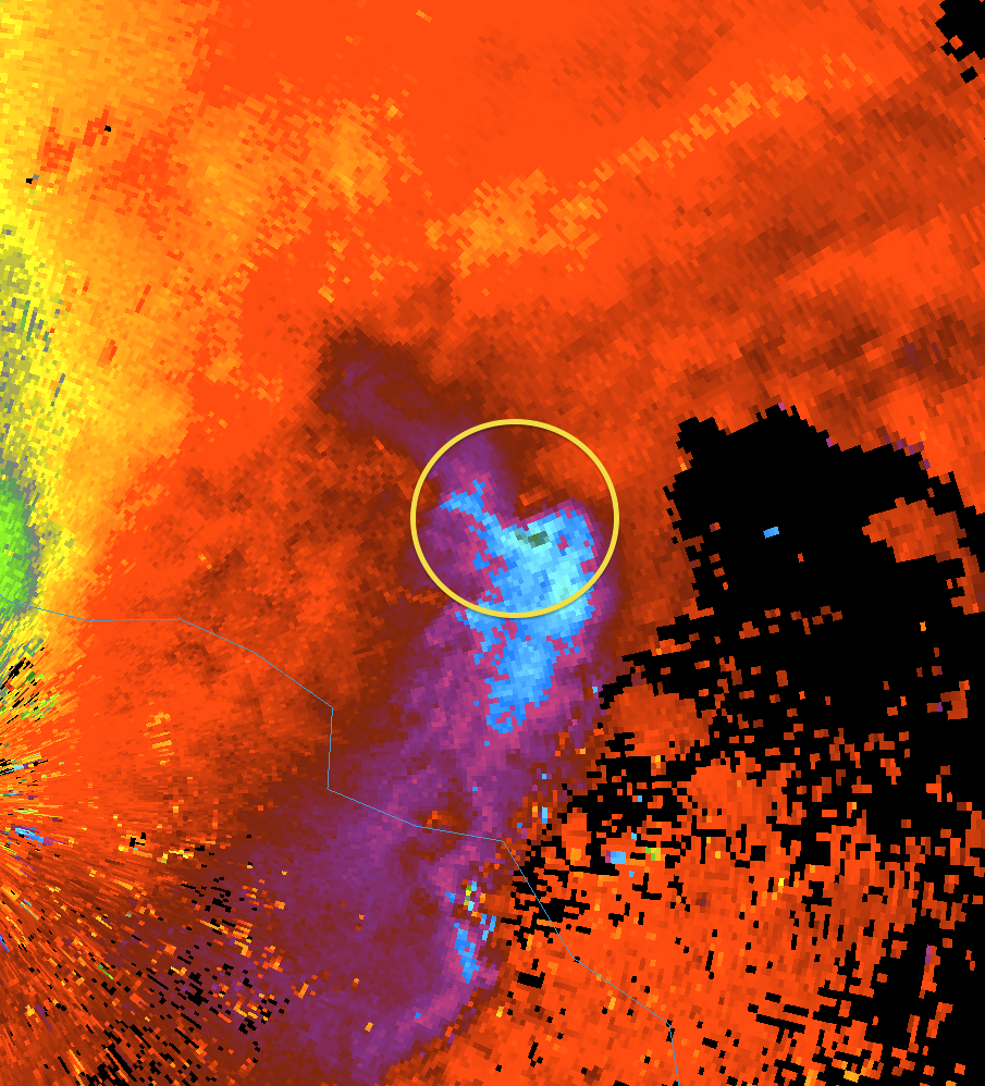
Eye looks worse on KTLH radar than on KVAX radar. I think we are getting some radar occlusion from that intense convection in the NW eyewall.
-
12 minutes ago, CoastalWx said:
At the time though it’s a little stretch to go 85 kts from 91 kts from FL winds. That was over 90 min ago too.
There was an eyewall dropsonde before NHC said 100mph that measured 98kt winds at 955mb (less than 1000 ft above surface). Suspect that’s what they used.

There is now a new dropsonde with 110kt winds about 1700ft above surface (921mb):

-
1
-
2
-
-
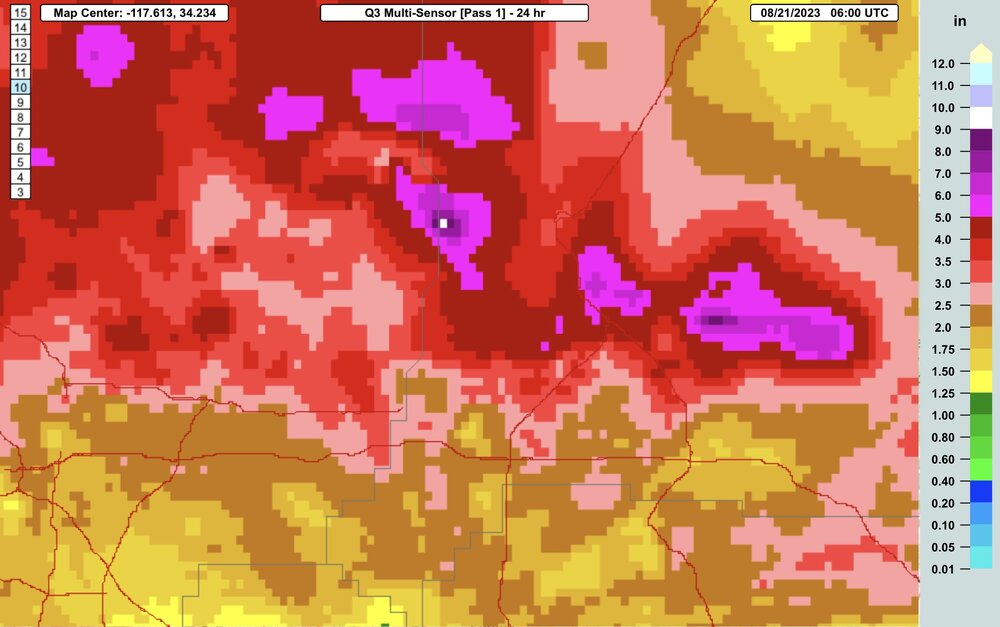
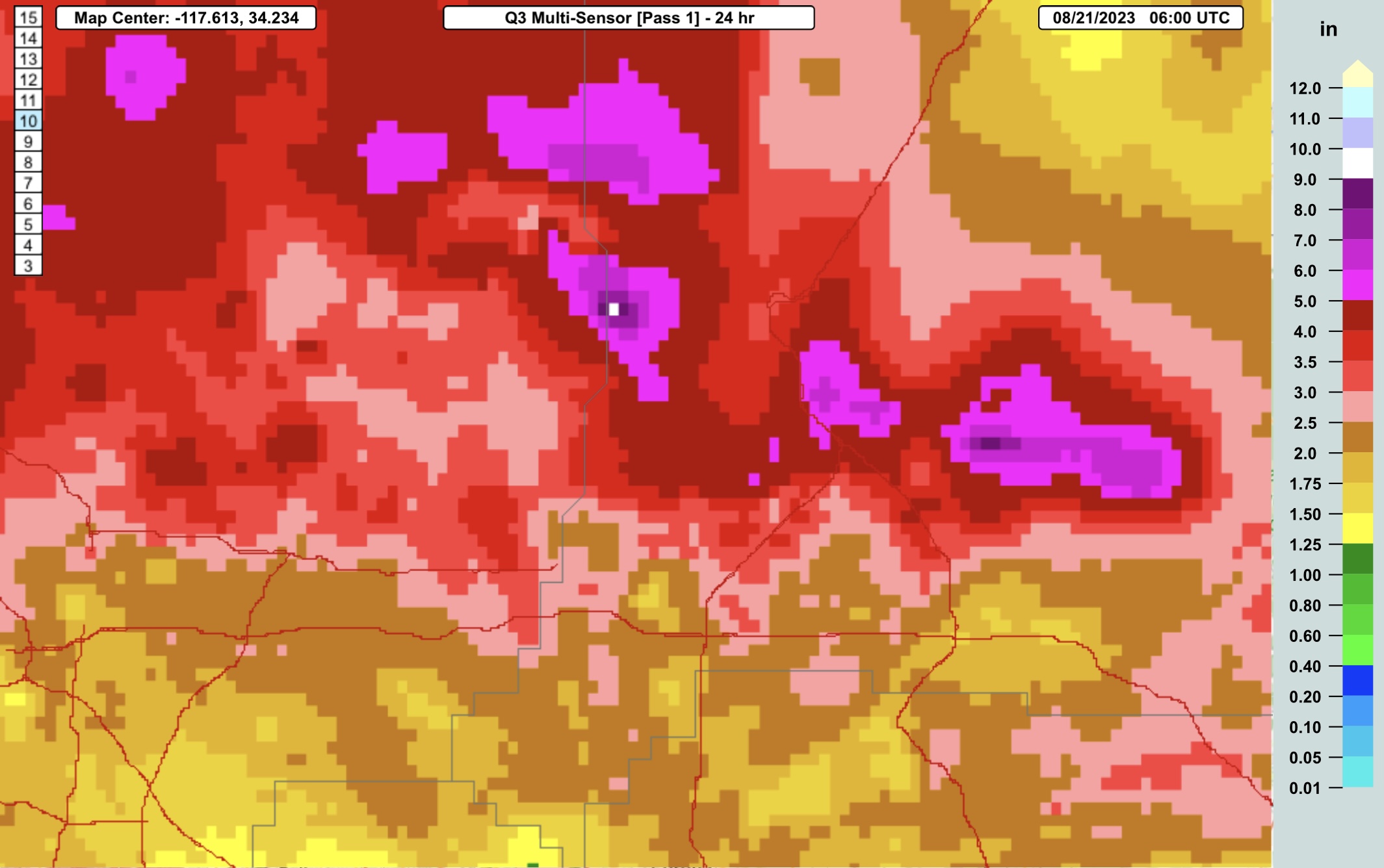
Some insane totals estimated in the mountains north of LA:
https://mrms.nssl.noaa.gov/qvs/product_viewer/ - Q3 Multisensor, 24 hr:
-
7 minutes ago, WxWatcher007 said:
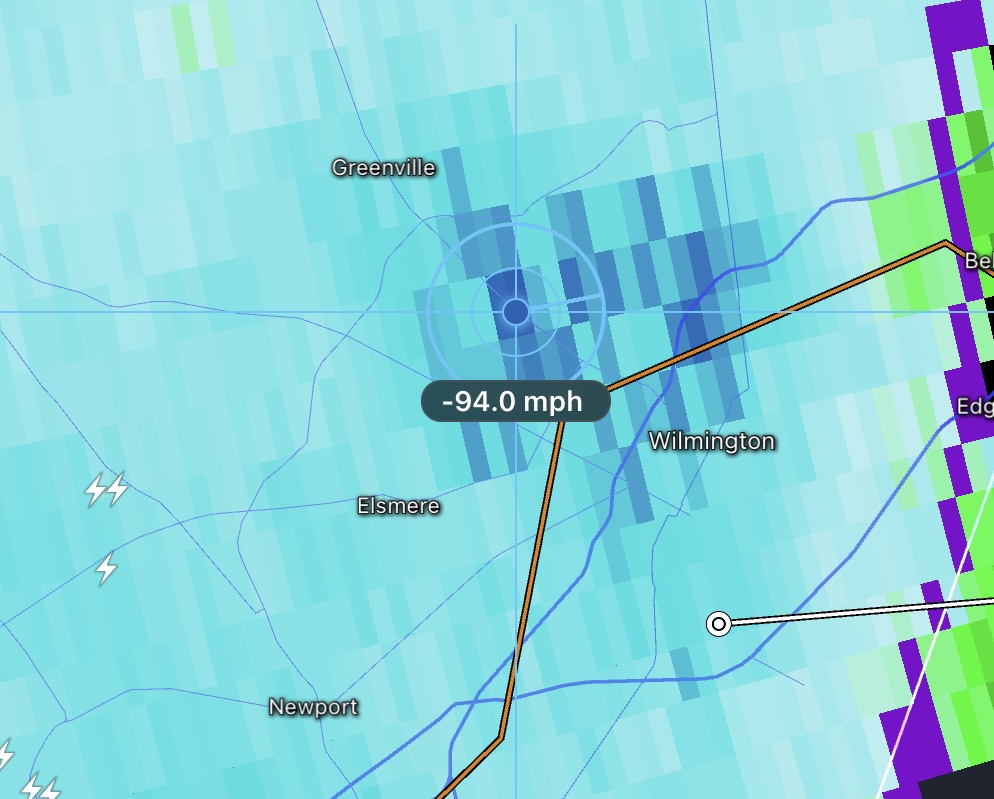
Philly may be in trouble.
Wonder what Wilmington got. Saw some 94mph readings on KDIX radar as it passed over there.

-
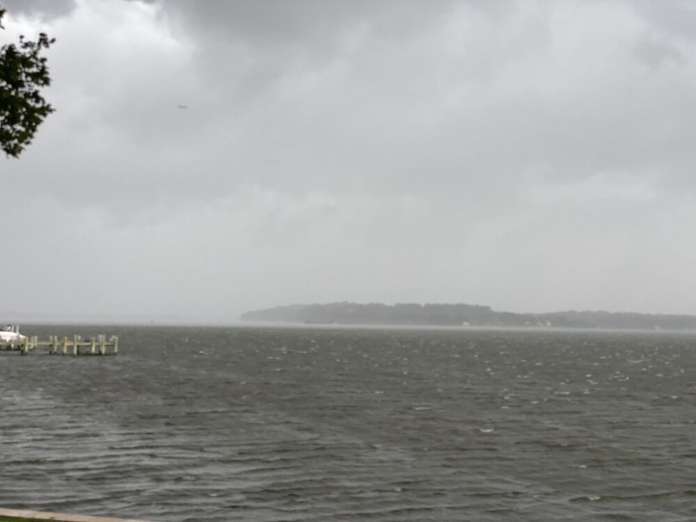
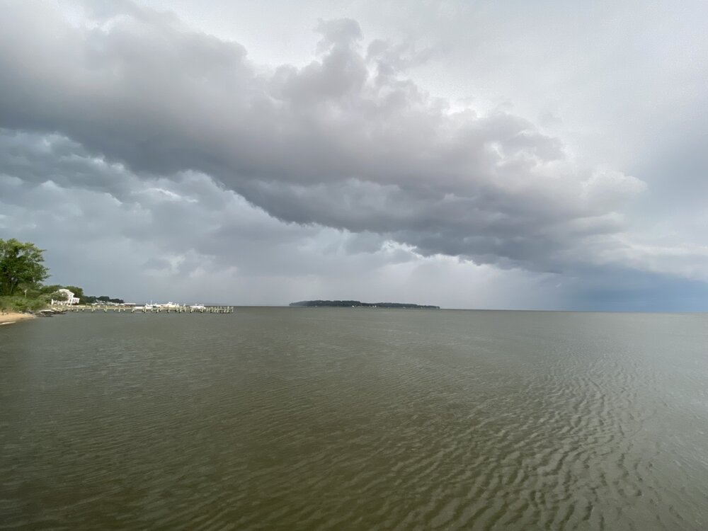
Moderate rain, 40mph wind peak. Happy to miss the worst of this line, still a while to go before the rain is done. The heavy winds moved just north of me basred on KLWX and KDOX radar. Power did flicker which caused my anemometer to stop reading at 40mph until I reset the receiver (never had that happen before), but I didn’t feel like the wind got much faster.
-
As the storm approached:
-
10
-
-
Anne Arundel
-
9
-
-
The hodographs look wild on the 3k NAM.
-
1
-
-
-
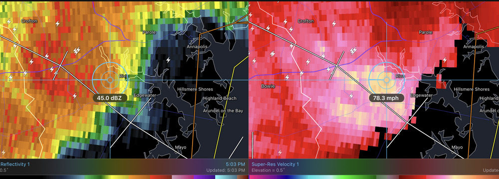
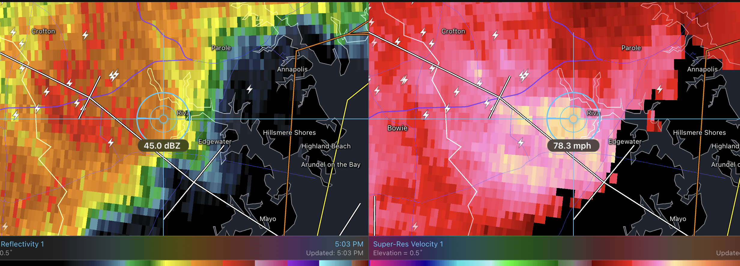
3 minutes ago, yoda said:
Velocities approaching 80mph SE of Crofton, MD
-
1
-
-
7 minutes ago, alexderiemer said:
I've seen quite the little inflow/rotation signature on this one..
Sent from my SM-F711U using Tapatalk
Tornado warning now for that cell.
-
17 minutes ago, Kmlwx said:
FV3 (0z run) looks abysmal for storm chances for many this afternoon. ARW and ARW2 look a bit better but not spectacular. HRDPS looks splotchy but passable for now. Yet another day of model solutions all over the map.
I was looking at current radar vs current models and HRRR, FV3, and NAM3K aren’t picking up what is currently on radar while HRDPS is.
-
1 hour ago, Eskimo Joe said:
That was my firs cradle to grave damage assessment. I was in the Emergency Operations Center and started to map out the initial damage points. It became pretty clear within about 30 min we had a tornado. Got out the next day at 7am with NWS to start looking at it.
To this day I still feel NWS under-graded that tornado. They called it a long track EF0, but my parents property appeared to have around 90mph EF1 damage. I know NWS never visited that location on the track. The official assessment talked about downtown Rockville and Sping Valley locations mostly, and ignored west Rockville where the damage was mostly wooded residential and park areas. One house up the street from my parents had 7 mid-sized trees land on it, shifting the house on it’s foundation but luckily only doing minor roof damage; they were able to repair it in a few months.
One thing clear from the photos my parents sent me was that it was a tornado: the 30" diameter oak was uprooted such that the tree fell to the right but the pivot point was above the rootball with the rootball to the left of the hole it came out of. Straight line winds would have it pivot from then forward edge of the rootball, and instead the entire rootball shifted about 8-10 feet left of that point, indicating the tree was lifted partially out of the ground then pushed over.
-
4 hours ago, Eskimo Joe said:
IMO, June 13, 2013: https://www.spc.noaa.gov/exper/archive/event.php?date=20130613
That’s the storm that dropped a tornado on my parent’s back yard, taking down 2 30"+ diameter trees parallel to their house and topping another 30" diameter tree.
June 13, 2013:

-
3
-
-
Not quite hitting severe where I am. 40mph 5.8"/hr rain is the peak so far. Zero visibility it’s coming down so fast. Already got 0.30" rain and am about half way through.


Category Five Hurricane Lee
in Tropical Headquarters
Posted
It’s amazing that even with shear now 24 hours in the core has been constantly emitting heavy lightning for the past 40+ hours. This storm seems primed to reintensify the moment the shear relaxes.