

Random Chaos
-
Posts
751 -
Joined
-
Last visited
Content Type
Profiles
Blogs
Forums
American Weather
Media Demo
Store
Gallery
Posts posted by Random Chaos
-
-
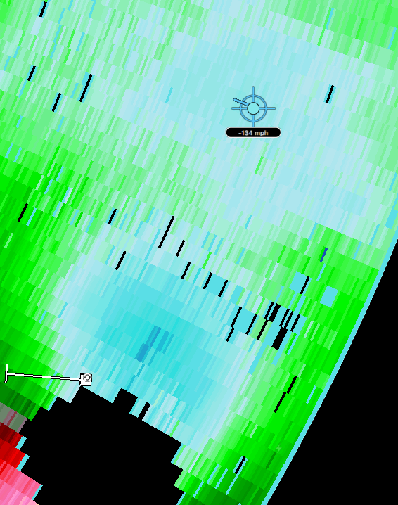
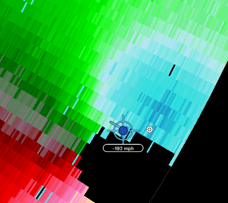
Outer eyewall has shrunk from about 28mi to about 22mi in the past hour, per radar.
-
 2
2
-
-
Just to compare a few numbers, flight level from the last recon pass was about 9000 feet when it passed through the secondary wind max, which was read as about 103mph (90kts) flight level winds. Higher altitude, winds will be less. We are now seeing widespread winds at 14000 feet at 120 to 130mph, with an occasional 130mph+ rate (radar estimated). This is in about an hour and a half. That's a big jump in the 2ndary wind max velocity.
(note: the 145mph readings on radar appear to be radar noise - they are all over, not just in the wind maxima regions)
-
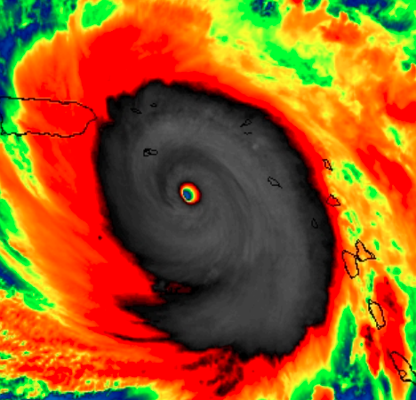
Seeing secondary wind max on radar @ 14k feet, and also a secondary ring of cold cloud tops starting to separate on IR:
-
Wow.
-
5
-
-
Just now, HillsdaleMIWeather said:
Special update, she's a Cat 5 again
160mph, 930mb in the 5:10 am special update.
-
Just now, Coopdog said:
The eye is determined to hit every portion of this small island, now going up the middle. The only part that might not come into direct contact is the far southwest portion of the island.
That northward wobble is terrible for the island.
http://www.meteo.fr/temps/domtom/antilles/pack-public/animation/anim_radar_mart_mf_com.html
-
1
-
-
Special update:
Hurricane Maria Tropical Cyclone Update
NWS National Hurricane Center Miami FL       AL152017
745 PM AST Mon Sep 18 2017

...HURRICANE HUNTER AIRCRAFT FIND MARIA AS CATEGORY 5 HURRICANE ON
THE SAFFIR-SIMPSON HURRICANE WIND SCALE...

Air Force Reserve hurricane hunter aircraft data indicate Hurricane
Maria has intensified into an extremely dangerous Category 5
hurricane on the Saffir-Simpson Hurricane Wind Scale with maximum
winds of 160 mph (260 km/h) with higher gusts.  A special advisory
will be issued at 800 PM AST (0000 UTC) in lieu of the scheduled
intermediate advisory for Maria.
SUMMARY OF 745 PM AST...2345 UTC...INFORMATION
---------------------------------------------------
LOCATION...15.3N 61.1W
ABOUT 15 MI...25 KM ESE OF DOMINICA
ABOUT 40 MI...70 KM N OF MARTINIQUE
MAXIMUM SUSTAINED WINDS...160 MPH...260 KM/H
PRESENT MOVEMENT...WNW OR 290 DEGREES AT 9 MPH...15 KM/H
MINIMUM CENTRAL PRESSURE...929 MB...27.43 INCHES
-
2
-
Hurricane Maria
in Tropical Headquarters
Posted
I measured it on RadarScope on two frames of its loop - 8:49 (28mi) and 9:40pm (22mi) EDT.