

Random Chaos
-
Posts
751 -
Joined
-
Last visited
Content Type
Profiles
Blogs
Forums
American Weather
Media Demo
Store
Gallery
Posts posted by Random Chaos
-
-
Looking at temperatures out in Ohio the HRRR is running close to correct while the NAM 3km is 5F warm. GFS is closer to HRRR than NAM but hard to tell specifics with only 3 hour data. Brrrrr.
-
2 hours ago, mdhokie said:
did this happen like an hour ago? im in howard county and noticed the lights flickered a couple times.
I flickered outside Annapolis at the exact same time the plane crashed too. Definitely some brief widespread grid disruption from this. They haven’t started rhe rescue yet - still getting equipment and crews in position - would not be surprised if the plane is still in the tower come morning.
-
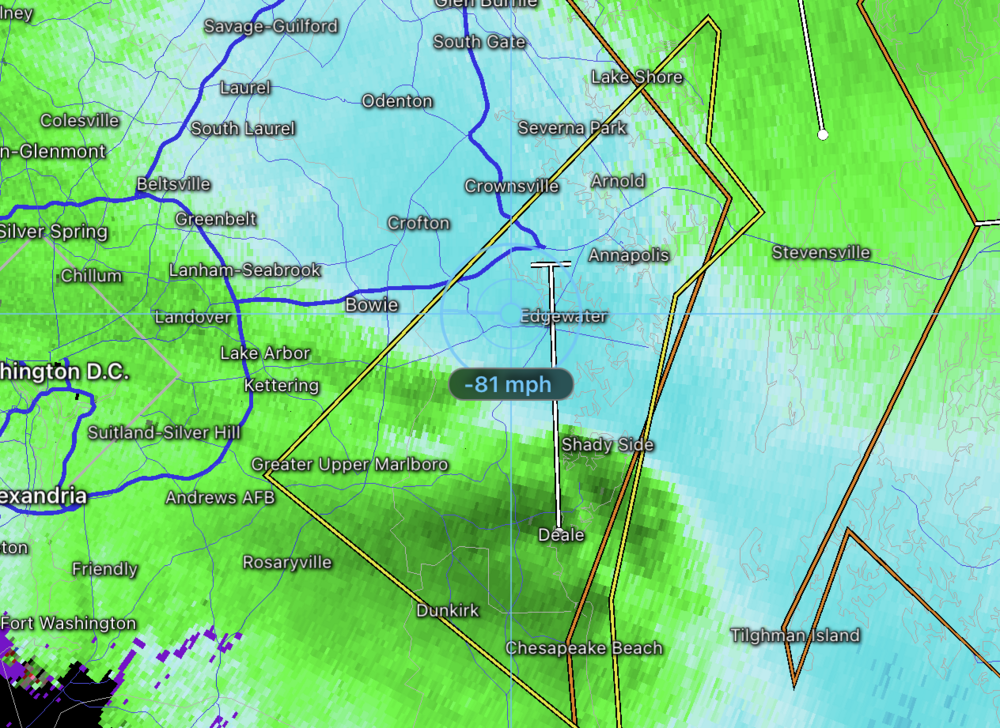
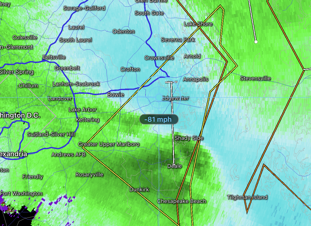
Downburst at up to 90mph in College Park. Nothing for Olney yet.
---
PUBLIC INFORMATION STATEMENT
NATIONAL WEATHER SERVICE BALTIMORE MD/WASHINGTON DC
153 PM EDT WED JUL 13 2022

...STORM DAMAGE SURVEY RESULTS FROM COLLEGE PARK IN PRINCE
GEORGE'S COUNTY MARYLAND...

TODAY, STAFF FROM THE NATIONAL WEATHER SERVICE
BALTIMORE/WASHINGTON WEATHER FORECAST OFFICE CONDUCTED A STORM
SURVEY IN THE CITY OF COLLEGE PARK IN PRINCE GEORGE'S COUNTY
MARYLAND. THE SURVEY IS IN RESPONSE TO THE SEVERE THUNDERSTORM
THAT MOVED THROUGH THE AREA BETWEEN 600-610 PM EDT ON TUESDAY JULY
12 2022.

THERE WAS EXTENSIVE DAMAGE IN THE CITY OF COLLEGE PARK, WITH MANY
TREES SNAPPED AND UPROOTED. SOME TREES FELL INTO RESIDENCES,
PRODUCING STRUCTURAL DAMAGE. PEAK WIND GUSTS WERE ESTIMATED AT
80-90 MPH. OBSERVATIONS FROM THE SURVEY SHOWED THAT THE DEBRIS
FELL GENERALLY TOWARDS THE EAST, PRODUCING A DOWNBURST PATTERN.

THESE OBSERVATIONS, COUPLED WITH VELOCITY IMAGES FROM THE FAA'S
TERMINAL DOPPLER WEATHER RADAR AT BWI THURGOOD MARSHALL AIRPORT
WHICH MEASURED 85 MPH WINDS AT APPROXIMATELY 1000 FEET ABOVE
GROUND LEVEL, ALONG WITH VELOCITY PRODUCTS FROM THE NWS KLWX WSR-
88D IN STERLING VA, CORROBORATE THAT THE MOST LIKELY CAUSE OF
STORM DAMAGE IN COLLEGE PARK WAS STRAIGHT-LINE WINDS EMANATING
FROM A SEVERE THUNDERSTORM.

STRAIGHT LINE WINDS FROM THUNDERSTORMS CAN PRODUCE TORNADO-LIKE
DAMAGE. YESTERDAY EVENING'S ESTIMATED WINDS IN COLLEGE PARK ARE
EQUIVALENT TO THAT OF A LOW-END EF1 TORNADO.

THE NATIONAL WEATHER SERVICE THANKS THE CITY OF COLLEGE PARK
DEPARTMENT OF PUBLIC WORKS IN ASSISTING WITH THE STORM SURVEY.
-
 2
2
-
-
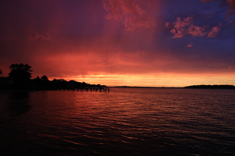
0.56" in my gauge yesterday. After it was over, beautiful sunset.
-
 12
12
-
-
I managed no real wind, just a lot if rain. Storm barely missed me south.
-
Looks like a broad area circulation over Annapolis, and now a tvs signature from Dover radar per radarscope image.
-
My rain guage shows 0.76", but that’s way low. First storm only registered 0.04" due to the wind driving the heavy rain straight sideways and not filling the tipping guage. Any suggestions on how to measure storms where the rain simply doesn’t go into the guage’s cone? 2nd storm dumped 0.64" and seemed to rain less than the first storm (but also less windy).
-
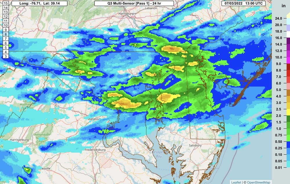
Here’s what NWS multisensor estimates:
-
I still rather have this thing east than west at this range. Rarely do I see storms move back east when we see a rain event, but we all the time see events move west on us...usually giving us rain as a result. I can live with a day or two of missed model runs for the hope that by mid-week the models are back with a solid hit on us.
That said, a fish spinner is definitely possible too. Just hoping that's not the way it goes
")
-
Hour 102. Nice h5.
-
1
-
-
Puking snow over Boston. Big take away, even with the significant h5 changes, is the model is still pumping out a monster storm. Just misses us in this run. I’d rather it be east and dry cold at this range than west and warm rainy.
-
0z looks very similar to the previous 6z at 144+/-.
-
I like the run-to-run consistency! Our best storms almost always show that at this range.
Snowicane here we come!


-
1
-
-
What I like: This storm has been periodically showing up on long ranges for several days now. Those that miss are missing east or not developing at all - and it seems like we get a east bias at range so that's in our favor for those that do put out a fish spinner.
What I don't like: It's still way too far out! Give it 3-4 days and I'll be onboard, especially if it's a little east of us.
-
1
-
-
6 minutes ago, stormtracker said:
What are the guesses on the new solution the 18z GFS shows? Im going to make a safe bet: It won't be the superstorm blizzard like 12z.
5 feet of snow right on top of Ji and everyone else is in a snow hole.
-
-
19 minutes ago, Yeoman said:
NGM and AVN, baby! I'm a half century this year, as well.. hard to believe
Nothing beats the CRAS
-
985.8mb, temperature up to 49.4F
-
1
-
-
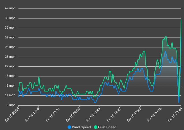
Winds howling now. 32mph. Gusts to 38. That was a wierd lull I had earlier.
-
My wind just died: 23mph 10 minutes ago, 1mph now.
Temperature spiked too - up 5F in the last 20 minutes to 44.5F.
the intense band is almost to me.
Pressure also started going back up.
-
1 minute ago, mattie g said:
F5 on The Mall?
Now I want snownado!
-
Some pretty intense winds aloft.
-
1
-
-
1 minute ago, wxdude64 said:
To bad it couldn't be a severe thundersnowstorm warning...
It is a severe thunderstorm warning. And a special marine warning for waterspouts and wind!
-
Waterspouts possible…
QuoteBULLETIN - IMMEDIATE BROADCAST REQUESTED
Special Marine Warning
National Weather Service Baltimore MD/Washington DC
1040 PM EST Sun Jan 16 2022The National Weather Service in Sterling Virginia has issued a
* Special Marine Warning for...
Chesapeake Bay from Drum Point MD to Smith Point VA...
Chesapeake Bay from North Beach to Drum Point MD...
Chesapeake Bay from Pooles Island to Sandy Point MD...
Chesapeake Bay from Sandy Point to North Beach MD...
Chesapeake Bay north of Pooles Island MD...
Chester River to Queenstown MD...
Choptank River to Cambridge MD and the Little Choptank River...
Eastern Bay...
Patapsco River including Baltimore Harbor...
Patuxent River to Broomes Island MD...
Tangier Sound and the inland waters surrounding Bloodsworth
Island...* Until 1215 AM EST.
* At 1039 PM EST, a shower capable of producing waterspouts was
located over North Beach, moving north at 45 knots.HAZARD...Wind gusts in excess of 50 knots and waterspouts
possible.SOURCE...Radar indicated.
IMPACT...Boaters could easily be thrown overboard by suddenly
higher wind and waves capsizing their vessel. Boats could
suffer significant damage in high winds. Waterspouts can
create locally hazardous seas.* Locations impacted include...
Choptank River, Kent Narrows Bridge, North Point State Park,
Magothy River, Chester River, Eastern Bay, Blackwalnut Point,
Pooles Island, Cuckold Creek, Herring Bay, Gunpowder River, Sandy
Point State Park, Bloody Point Light, Thomas Point Light, Calvert
Cliffs, Poplar Island, Parsons Island, Fort Smallwood State Park,
Pinehurst and Saint Leonard Creek.LAT...LON 3955 7600 3916 7628 3900 7617 3871 7635
3867 7634 3878 7629 3860 7605 3861 7607
3863 7617 3863 7629 3853 7620 3848 7633
3832 7615 3832 7651 3870 7655 3902 7640
3926 7665 3923 7643 3946 7629 3937 7622
TIME...MOT...LOC 0339Z 185DEG 44KT 3869 7648WATERSPOUT...POSSIBLE
HAIL...0.00IN
WIND...50KTS$$
-
1
-


December 22-23, 2022: Warm Rain to Arctic Chill
in Mid Atlantic
Posted
Just switched to snow here. 39F and dropping fast.