

Random Chaos
-
Posts
751 -
Joined
-
Last visited
Content Type
Profiles
Blogs
Forums
American Weather
Media Demo
Store
Gallery
Posts posted by Random Chaos
-
-
Peak gust 39mph about an hour ago.
1.11" rain.
-
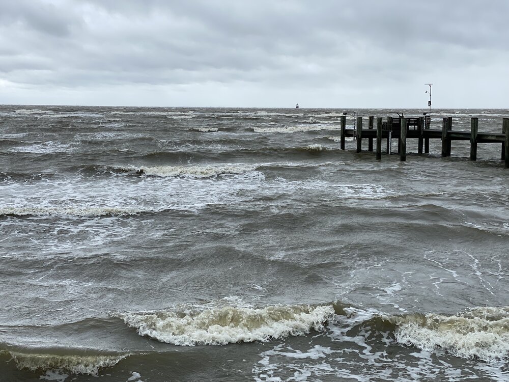
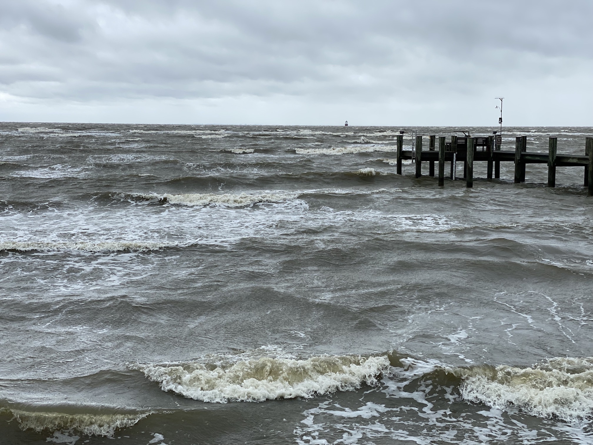
Wind so far (graph) and sea state. Photo has my anemometer in it on the pier. Tide is around 1' datum (0.5' MLW).

-
 6
6
-
-
0.87" rain, nothing coming down right now.
Tide about 0.5’ Datum (believe that is about 0.0’ MLW based on Annapolis being -0.55 datum to MLW).
Winds are around 25 gusting 30. They peaked earlier today 30 gusting 38.
-
Just lost power. Winds 26-28 gusting 35.
-
5 minutes ago, Kmlwx said:
Gusts, not sustained I believe
3 minutes ago, Kmlwx said:Also due to it being in transition by the time it gets up here.
Transition more likely the reason. Winds are forecast (just north of Bay Bridge):
Tonight NE wind 19 to 24 kt, with gusts as high as 34 kt. Rain, mainly after 11pm. Seas 3 to 4 ft.
Saturday NE wind around 30 kt, with gusts as high as 44 kt. Rain. Seas 5 to 6 ft.
Saturday Night NE wind 27 to 32 kt decreasing to 17 to 22 kt. Winds could gust as high as 41 kt. Rain. Seas 6 ft subsiding to 3 ft.
Though models actually show strongest winds tonight closer 30-35kt gusts 50kt+
-
Little surprised that there is not even a Tropical Storm Watch for the northern Chesapeake Bay. Most of the models are predicting 35-40mph-winds.
-
1
-
-
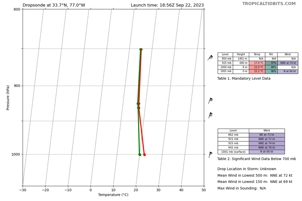
9 minutes ago, WxWatcher007 said:
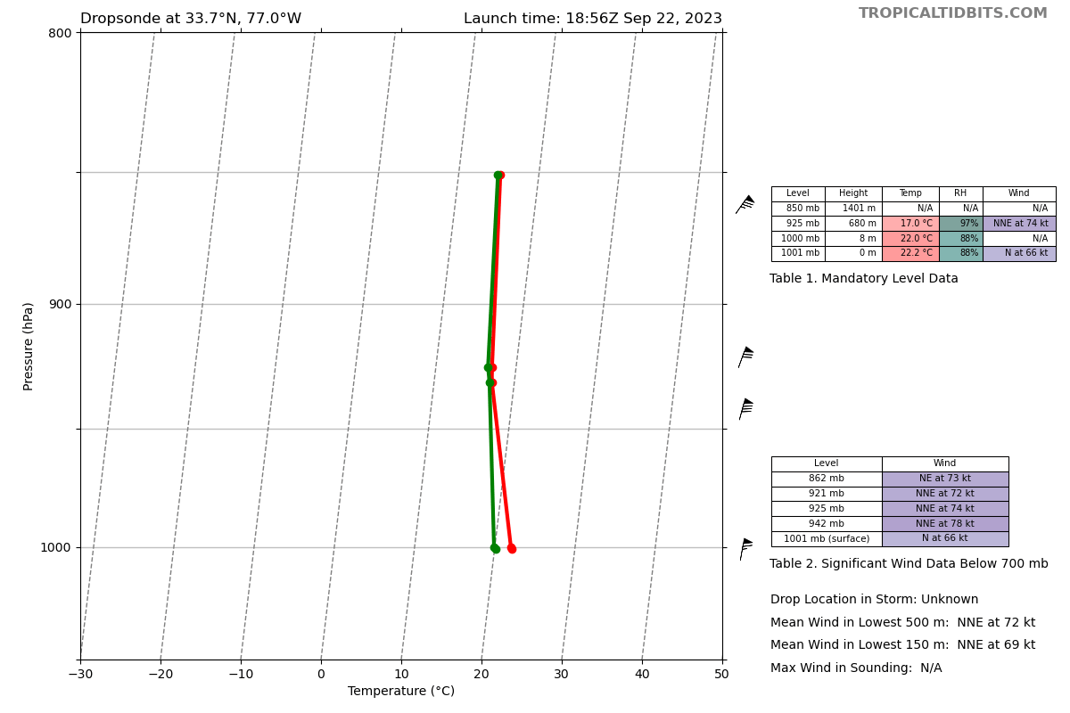
That was at 925mb. The surface reading was at 58kt.
The extrapolated pressure falls between passes is pretty good.
No, 925mb on what I posted was 74kt. Surface at 1001mb was 66kt.
-
1
-
 1
1
-
-
15 minutes ago, NorthHillsWx said:
It wouldn’t surprise me to see hurricane warnings coming out shortly based on that pass. FL 75 kts, SFMR 60-62 kts
And dropsonde with 66kt surface.
-
1
-
-
Dropsonde found 66kt at surface NW of center. Category 1 threshold is 64kt.

-
1
-
-
Just now, Scraff said:
OMG. I better load up the beer fridge!!

You might lose power. Better stock on ice chests instead.
-
 2
2
-
-
2 minutes ago, CAPE said:
Found this interesting little nugget buried in the very extensive AFD from Mount Holly this morning:
I was looking at the shear map’s just yesterday morning expecting that. With the vorticity of a tropical cyclone when storms in its bands come ashore it’s common to get weak tornadoes.
-
1
-
-
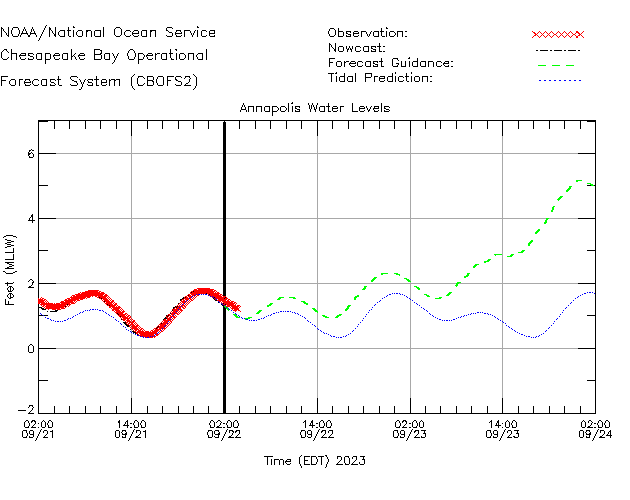
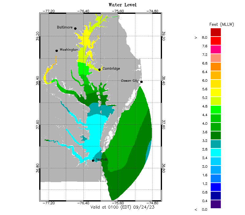
Extreme tides now forecast for Annapolis:
-
1
-
1
-
-
1 hour ago, AACOUNTYMD said:
Question. . . should Eastern AA county expect the highest winds before, during, or after the heaviest rains? And would that be over night Friday or more during daylight hours on Saturday?
Based on the model output, heaviest winds near the bay are likely overnight Friday into Saturday AM, probably from around midnight to 10am. This is a band well ahead of the main storm which will still be down in North Carolina at that time. Midday Saturday we should have relaxed winds (still 20kt+) and less gusty between the leading band and the main storm before it picks up again Saturday evening as the main storm center approaches, though less windy than the leading band the previous night.
Heaviest rain is harder to forecast due to substantial model divergence but seems to generally correspond to the heaviest winds.
-
1 hour ago, Weather Will said:
WB 18Z EURO is all in now.


Where’s the rain/snow line?

in seriousness, don’t like 58mph gusts near me… -
2 minutes ago, H2O said:
I wanna chase this so bad. But got one kid doing XC and kids have homecoming stuff all weekend. Wanna see how low the bay gets on the east side from those NE winds
I plan to post data on how high the tide gets on the west side. Got a staff gauge on my pier zeroed to zero datum (can look up the offset from mean low water to that).
-
4
-
-
1 minute ago, 87storms said:
The Commanders are 2-0, the Orioles might win 100 games, and it's been raining in Frederick. Times are changing.
I'll believe it when we get snow.
-
3
-
2
-
-
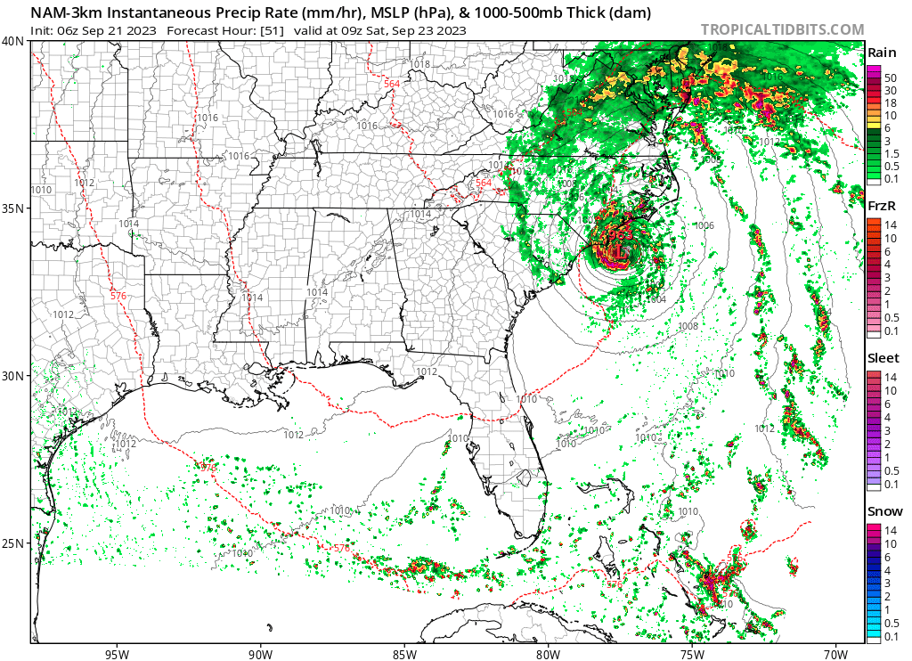
Waiting for CBOFS tide forecasts to get in range. Wind direction is going to be NE initially which will push water toward the western side of the Bay. This is NHC:

-
2
-
2
-
-
3 minutes ago, alexderiemer said:
I can't remember the last time they moved so quickly through the stages. We went from a 40% orange to advisories on a PTC in what, an hour??
Was even faster - the 40% was in the 2-7 day period. It was only 10% in the 48hr period just 3 hours ago.
-
The ASCAT pass I posted in the other Tropical subforum thread shows a closed low as of 4 hours ago. So not surprised they are escalating quickly.
-
3
-
-
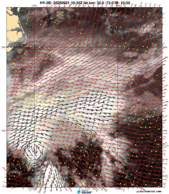
ASCAT pass from about 4 hours ago:
-
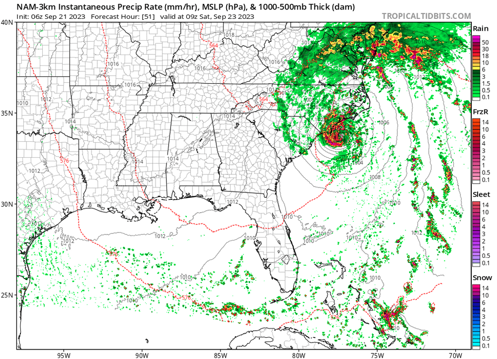
Oh NAM…
I know it’s not good with tropical systems…
but wow…963mb cyclone
-
2
-
 1
1
-
-
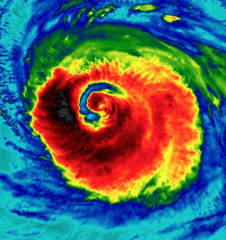
This is going to be one giant eye when it finishes clearing out the remnants of the old eye. Probably 12-ish hours left on that.
-
1
-
-
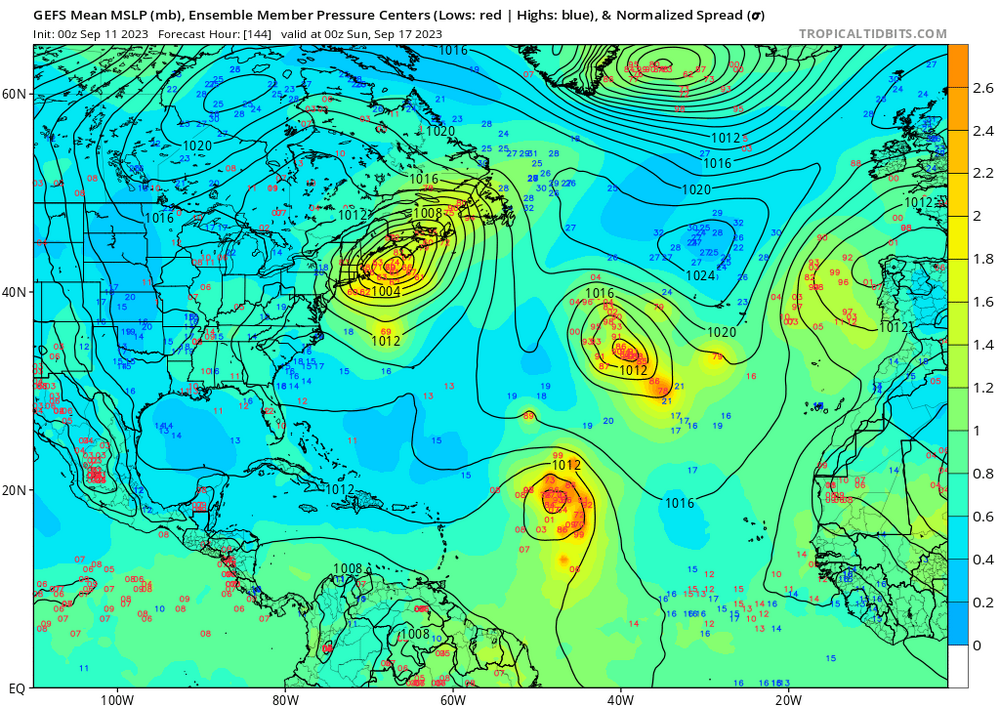
0Z GEFS has 100% of the members showing a landfall in either New England or adjacent Canada, with a fairly even distribution between Long Island through Newfoundland & PEI.
-
4
-
1
-
1
-
-
It is impressive it’s maintaining 959mb pressure with an open eyewall (per latest dropsonde and vortex report). But it feels like 87kt might be underestimated; 3 hours ago a dropsonde found 96kt surface winds and the latest dropsonde found 86kt surface winds with two 106kt unflagged SFMR readings. This system seems stronger than it has any right to be given the shear and satellite appearance. I also feel the standard flight level to surface wind adjustments haven’t matched what empirical data has shown with this storm the last two days; the surface winds are consistently stronger than they should be given observed flight level winds.


Tropical Storm Ophelia—Tropical Storm Warning for Coastal Mid-Atlantic
in Mid Atlantic
Posted
We are near peak tide (peak tide was estimated starting around 1am and lasting through about 3am).
Measured based on NAVD88 Datum a tide height of 3.0'. Per Annapolis data, MLW is -0.55' vs Datum. This was average height with waves.
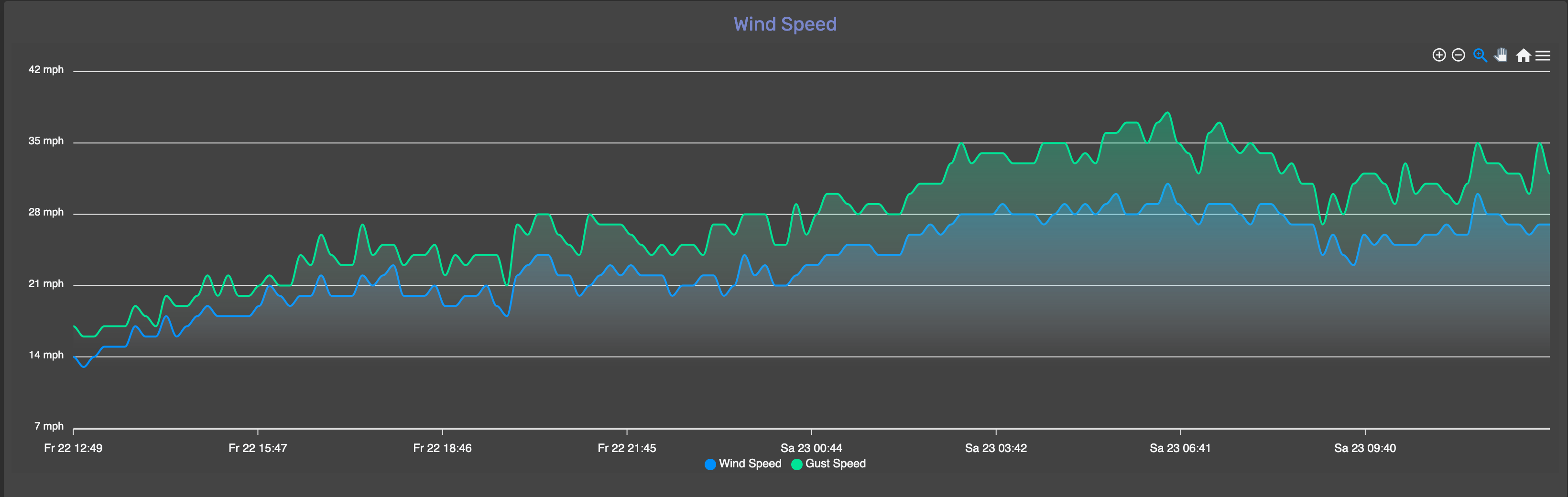
Winds have dropped off, now 22-25mph gusts 25-28mph from the ENE (same direction they have been running the past several hours). Forecast was for the winds to hit slack near high tide as the wind directions shifts from NE to S as the circulation center moves through. You can see the modest drop off in wind speed here:
This photo is of the staff gauge calibrated to NAVD88 Datum at a null in wave activity that lasted about 30 seconds.