

Random Chaos
-
Posts
751 -
Joined
-
Last visited
Content Type
Profiles
Blogs
Forums
American Weather
Media Demo
Store
Gallery
Posts posted by Random Chaos
-
-
New tide forecast out. It's higher than the previous one yet again, by about 2-3".

-
 2
2
-
-
Peak tide has been increased slightly with this morning's forecast:

Source: https://tidesandcurrents.noaa.gov/ofs/cbofs/cbofs.html
-
There is an anemometer on the bay bridge.
In addition my anemometer is near the bridge but exposure to winds during this storm will be slightly sheltered (wind directions are off shore for me, so mixing to the anemometer height is impacted by trees and houses a bit, especially after the winds reach south of due southeast) so I might not read peak. Link in my sig to my weather station.
-
57 minutes ago, Brianonymous said:
I had put this in the wrong thread, so I corrected ->
AACo schools just issued a 2hr early closure for tomorrow. The heckin heck?
And I quote: AACPS: Due to expected heavy rain, strong winds, and deteriorating road conditions
Tides will be high enough (5+ feet) to flood out roadways near the water, especially toward evening. Prudent for them to dismiss early to make sure busses can actually get the kids home. Early closure also terminates after school activities which would be even more impacted by the tide levels. Tides over 3 foot will cover some coastal roads; tides over 4 feet will have widespread impact and make some roads impassible. Tides are supposed to break 5 feet.
0
-
1
-
-
1 hour ago, Terrapinwx said:


Going to be lots of erosion on the bay if we get a 5 ft surge with 6 ft waves. Luckily the peak wind/waves should be brief compared to most storms
.If this comes to pass, severe erosion on southerly exposed shorelines (SE to SW exposure) on the bay. 5 foot+ tides north of southern AA County with strong winds and big waves. The closest analog to this tide level and wind direction is Isabel (6.5 foot tide). If a property was damaged in Isabel, likelihood is that it will be damaged in this storm.
This is very different than the October 2021 storm (3.5 foot tide) that had northeasterly wind and damaged a different shoreline (those exposed to waves from a northeasterly direction) with 3.5 foot tides. Locations damaged in that storm will likely have less impact from this storm due to wave exposure being less.
-
1
-
-
5 minutes ago, Imgoinhungry said:
Snowstorm followed by behemoth rainstorm three days later. Id imagine flooding would be a significant concern.
.Got to stay positive. There is still time for that behemoth rain storm to realize it’s better as snow

-
1
-
-
All aboard weenie wonder land!

Why does the GFS keep teasing us with day 14+ snow? It’s been at this for weeks!
-
33 minutes ago, Weather Will said:
You mean this that I should not post from fantasy land? I have no idea how much it is going to snow this season but the vibe is definitely different. WB 6Z GFS


Dang, I was just coming here to post that! I’m ready for a HECS after the last few years!
-
2
-
 1
1
-
-
Those are some pricy boats totaled too…
-
With Otis in the news, I saw this paper on rapid intensification was published earlier this month, detailing both the typical rapid intensification plus a newly discovered mechanism of rapid intensification.
Article about the paper: https://phys.org/news/2023-10-scientists-ways-hurricanes-rapidly.html
The paper (paywall): https://journals.ametsoc.org/view/journals/mwre/151/10/MWR-D-23-0038.1.xml
-
1
-
 2
2
-
-
11 minutes ago, LongBeachSurfFreak said:
I’m actually shocked and appalled by the lack of coverage of this, soon to be, humanitarian crisis. This was the big one, for Mexico.
I agree, but one of the coverage issues is the lack of information out of there. Even 1.5 days after the hurricane hit we are getting only a very few videos and pictures from the location. All the roads to there are inaccessible. And because of the short warning, media and storm chasers didn't have time to pre-stage near the landfall location. Until media is able to actually get access, I wouldn't judge too harshly the lack of coverage. If, once media can get access, lack of coverage continues, then I too will be appalled.
-
2
-
-
I decided to look at the EF damage scale for high rises for what we are seeing. While we don't have the negative pressure of a tornado (so thus roof damage isn't expected), some of the other damage level categories are likely valid. I am specifically looking at damage level category 8 "Significant damage to curtain walls and interior walls" for 20+ story high rises - some of the videos and pictures that have come out show entire portions of floors appearing wiped clean of walls. The wind range for a tornado to do significant wall damage is lower bound 123 to upper bound 172mph, with the average point that this damage appears at 145mph. Given that the hurricane was estimated 165mph at landfall, this damage level makes sense. Additionally, the high rise is likely to sustain more damage than ground level - winds are stronger 100+ feet above the ground than they are at the surface, and the 165mph was surface winds. We could have seen 185 to 200mph at the tops of some of these buildings.
-
2
-
-
-
New update:
000
WTPZ63 KNHC 250459
TCUEP3

Hurricane Otis Tropical Cyclone Update
NWS National Hurricane Center Miami FL       EP182023
1200 AM CDT Wed Oct 25 2023

...EYEWALL OF POTENTIALLY CATASTROPHIC CATEGORY 5 HURRICANE OTIS
MOVING ASHORE NEAR ACAPULCO MEXICO...
...12 AM POSITION UPDATE...

Satellite imagery indicates that the eyewall of potentially
catastrophic Hurricane Otis is moving ashore the southern coast of
Mexico near Acapulco.  Maximum sustained winds are estimated to be
165 mph (270 km/h) with higher gusts.  Otis is a category 5
hurricane on the Saffir-Simpson Hurricane Wind Scale.  Otis is
forecast to remain a category 5 hurricane through landfall within
the next few hours.

SUMMARY OF 1200 AM CDT...0500 UTC...INFORMATION
-----------------------------------------------
LOCATION...16.5 99.7W
ABOUT 30 MI...50 KM SSE OF ACAPULCO MEXICO
MAXIMUM SUSTAINED WINDS...165 MPH...270 KM/H
PRESENT MOVEMENT...NNW OR 345 DEGREES AT 9 MPH...15 KM/H
MINIMUM CENTRAL PRESSURE...923 MB...27.26 INCHES
-
I’m thinking of some of the Central American Atlantic storms that have caused major mudslides with only a Cat 1 or Cat 2. The amount of rain this will drop is going to be bad. I’m not downplaying the wind, but the wind is often not the killer, it’s the flooding, mudslides, and storm surge (the later this storm has less risk with in part due to the short time between strengthening and landfall)
-
Just now, Windspeed said:
Helpful post regarding surge prone areas via Jeff Masters:
Also can’t forget flooding as the rain is squeezed out by the higher elevations.
-
Update from NHC;
Hurricane Otis Tropical Cyclone Update
NWS National Hurricane Center Miami FL       EP182023
1100 PM CDT Tue Oct 24 2023

...POTENTIALLY CATASTROPHIC CATEGORY 5 HURRICANE OTIS STILL
STRENGTHENING AS IT NEARS THE COAST OF SOUTHERN MEXICO...

Recent satellite data indicate that Otis continues to strengthen.
The maximum sustained winds are now estimated to be near 165 mph
(270 km/h) with higher gusts.  Otis is a category 5 hurricane on
the Saffir-Simpson Hurricane Wind Scale.  Otis is forecast to
remain a category 5 hurricane through landfall overnight.
-
1
-
-
Lightening in the eyewall is still firing off:
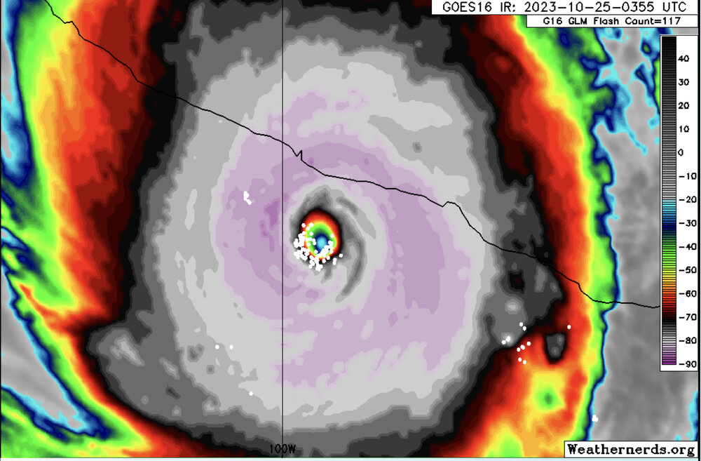
-
1
-
-
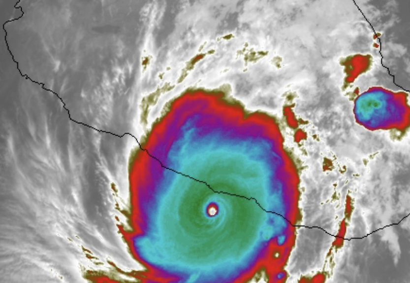
Incredible core on IR now. Really cleared out.
Image from https://weather.ndc.nasa.gov/GOES/ using IR9 color scale.
-
 1
1
-
-
Low overnight of 47.2. Quite a bit warmer than a lot of you.
-
Just now, Eskimo Joe said:
Almost looks like a cold conveyor belt on radar.
Just got to ignore that spin near La Plata and it definitely does

-
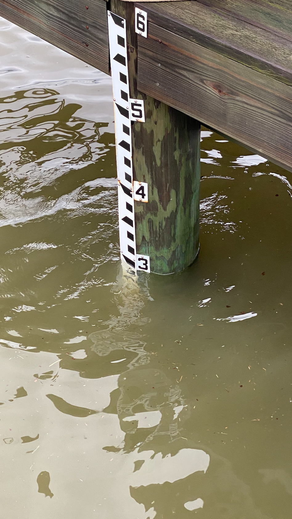
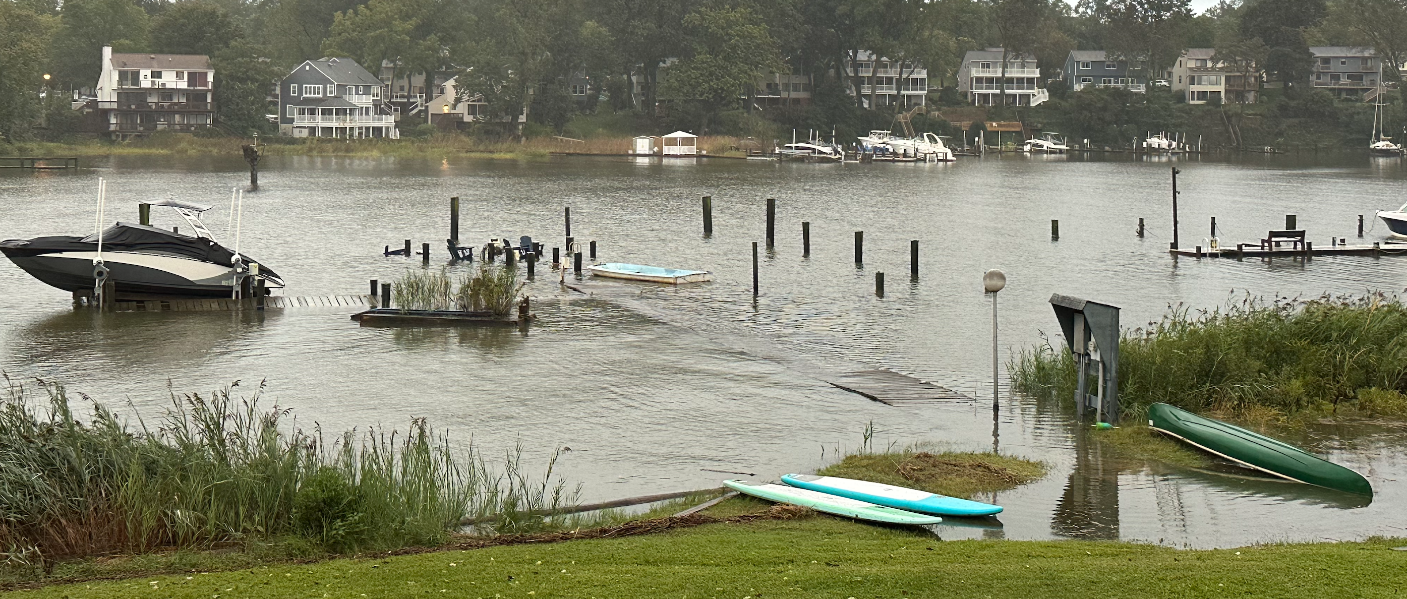
Staff gauge this morning (about 8:30am) in NAVD88 Datum:
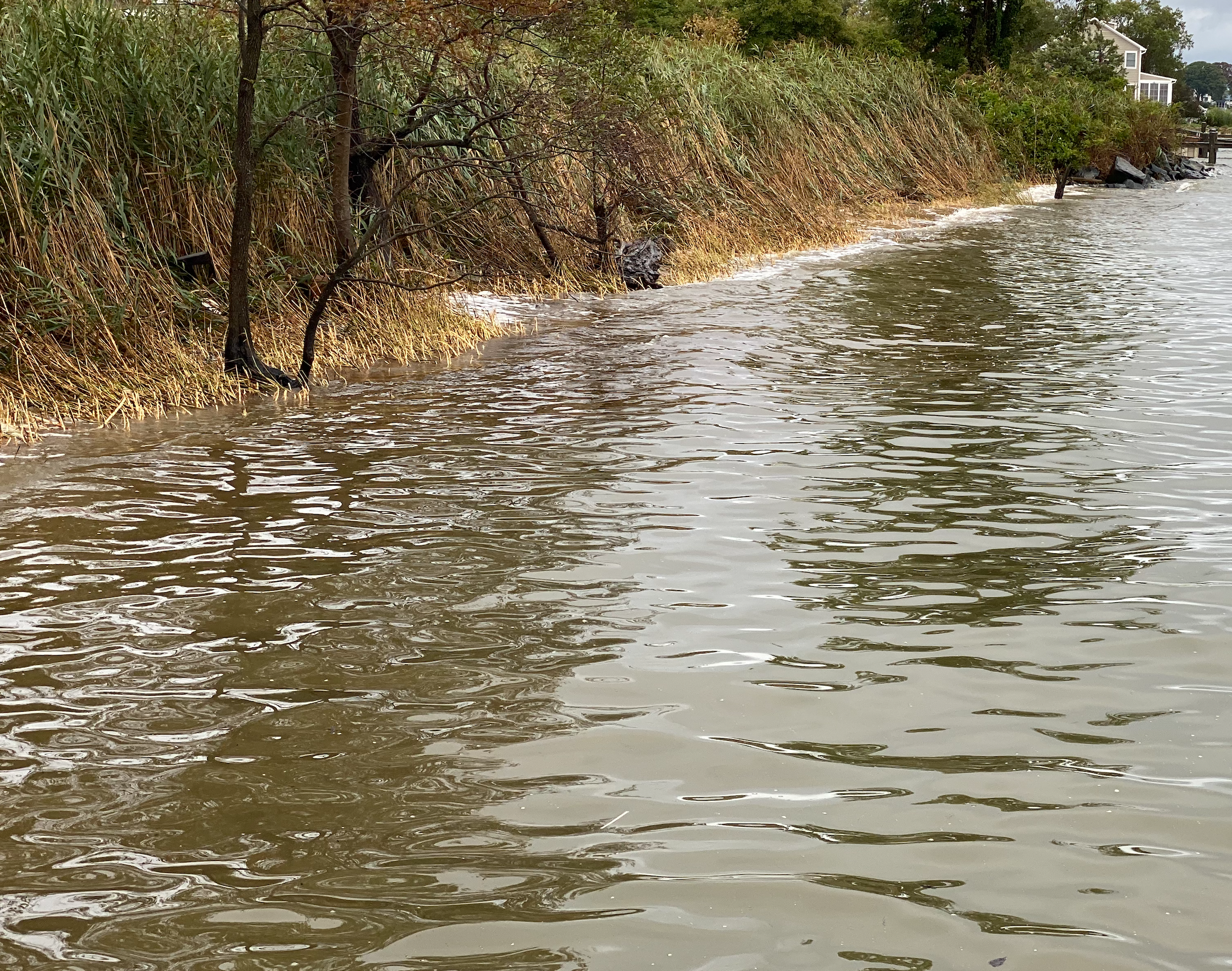
This beach normally has about 15 feed wide sand:
And a neighbor sent me this from about a mile and a half from me:
-
7
-
-
4 minutes ago, alexderiemer said:
Local Mets mentioning the remnants loop back and hit as another nor easter next weekend
Sent from my SM-F711U using Tapatalk
Yeah GFS has been suggesting that the past day:
-
1
-
-
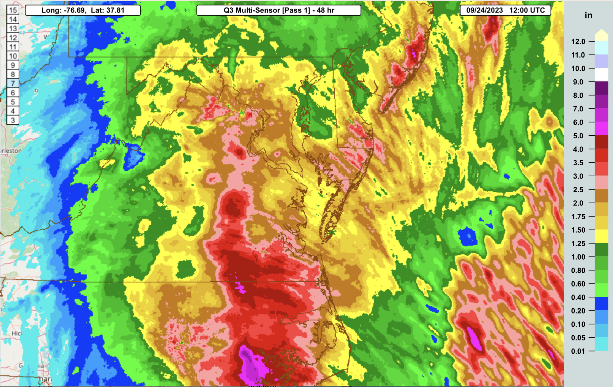
While it's still raining in some areas, here are initial rainfall estimates from https://mrms.nssl.noaa.gov/qvs/product_viewer/
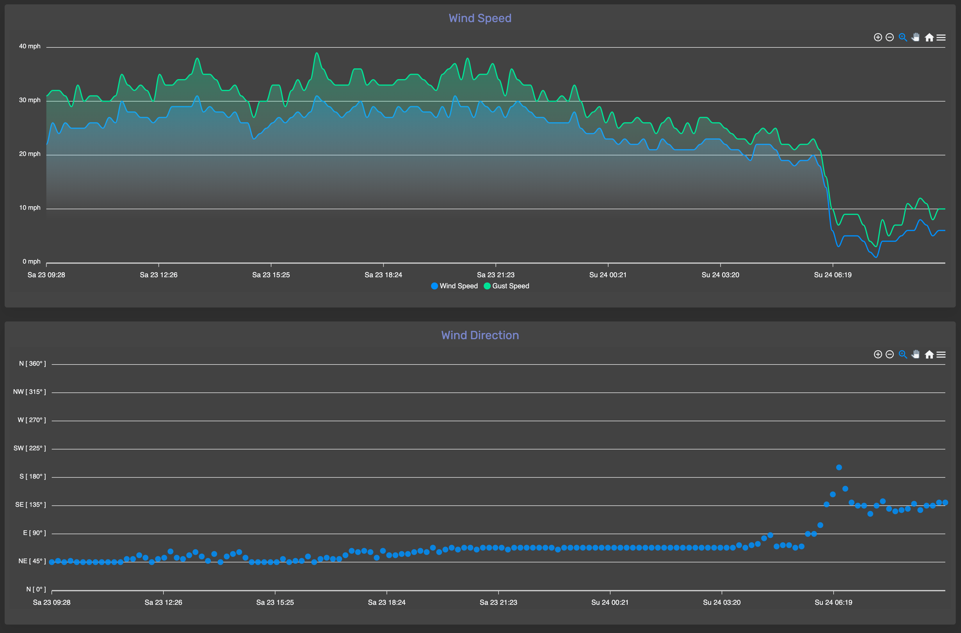
And here's my anemometer output:
-
8
-


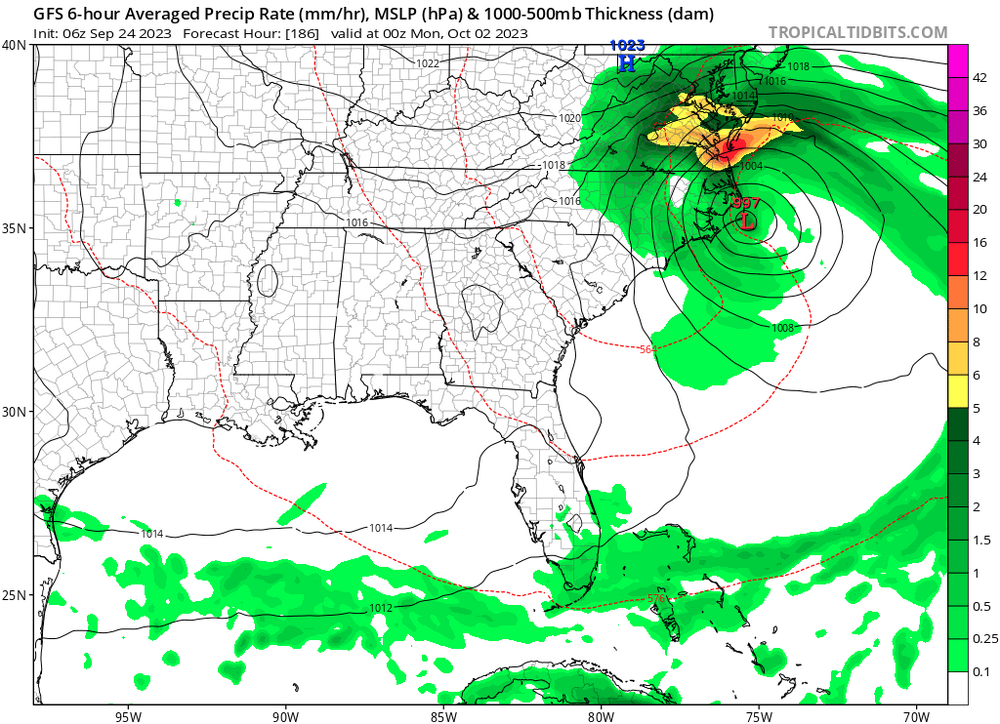
Tuesday, January 9 Rain and Wind Storm
in Mid Atlantic
Posted
If we get this height (5.5 feet above MLLW), yes. The next highest was October 2021 at 4.88 feet above MLLW. Isabel was 7.20 feet above MLLW. There were two other storms in the past 100 years to breach 4 feet - 1950's and 1930's
Annapolis Isabel: https://tidesandcurrents.noaa.gov/waterlevels.html?id=8575512&units=standard&bdate=20030915&edate=20030923&timezone=GMT&datum=MLLW&interval=h&action=
Annapolis October 2021: https://tidesandcurrents.noaa.gov/waterlevels.html?id=8575512&units=standard&bdate=20211026&edate=20211104&timezone=GMT&datum=MLLW&interval=h&action=