

ariof
-
Posts
664 -
Joined
-
Last visited
Content Type
Profiles
Blogs
Forums
American Weather
Media Demo
Store
Gallery
Everything posted by ariof
-
DJF with 8.6" of SN at BOS, and monthly anomalies of 4.3, 4.2 and 5.5. That whole winter was Morch.
-
Clipper Fires In Wednesday Feb 25 Disco/ Obs
ariof replied to Damage In Tolland's topic in New England
SN/SN+ in Kendall Square. Viz <1 mi (probably around 3/4 based on which building outlines I can and can't see). -
Clipper Fires In Wednesday Feb 25 Disco/ Obs
ariof replied to Damage In Tolland's topic in New England
Roads in CT look pretty awful, with everyone going back to work and the storm hitting right at rush hour. 2:15 to go 31 miles from Bridgeport to Rye. Ugly.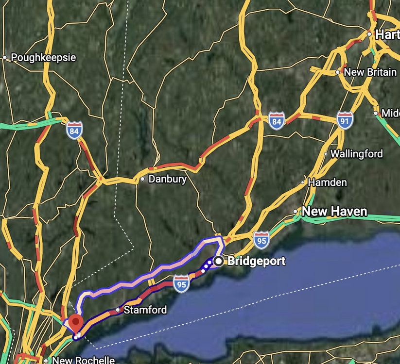
-
Today is day 32 below 42° in Boston in a row. Longer periods: 43 (ending 2015-03-03) 42 (1969-03014) 40 (1936-02-25) 39 (1985-02-09) 37 (1945-02-10) 36 (1981-01-18) 35 (1966-02-09) 35 (1875-02-02) 34 (2011-02-05) 34 (1901-02-25) 33 (2009-01-31) Not a lot of modeling showing it going above 40 in the next week, although the sun angle may start to help.
-
"Don’t do it" 2026 Blizzard obs, updates and pictures.
ariof replied to Ginx snewx's topic in New England
I heard the same thing. 40 is not out of the question! -
"Don’t do it" 2026 Blizzard obs, updates and pictures.
ariof replied to Ginx snewx's topic in New England
Report from Mass Pike from 05Z-08Z last night: Snow began around ALB, west of there was clear sailing (a bit of -SN near BUF which dried out as the storm wrapped in dry air out there). Heavy band over the Berkshires, probably some upsloping. Lots of trucks pulling off at Blandford, and we went down the hill on our own. Picked up series of plows east of there, could make about 45 mph when we didn't have plows and the plows went 15 mph, but were helpful. Varying intensity of -SN to +SN, some drifting but not actually too bad. Accumulation got much lighter around 128, last 10 miles into Boston were fine. If Avis hadn't had a miles-long line in CLE (Hertz saved us, eventually) we would have been nearly an hour ahead of things and probably that would have cascaded to hitting snow further east and having an easier time. But still we beat the worst of the weather, friends made it to Maine. I don't think the Pike east of ORH would be reasonable now. -
Let me say that this Cory fellow has a heck of a track record. When do we set up a gofundme to send him out of town the days before Christmas next year? We'll get the Grinch to jump over the BM with that!
-
BGR and BTV might be the only commercial fields in New England to see flights on Monday.
-
If they are coming in the morning … they might get canceled. If they are coming in the afternoon … they should be fine. If they think they are going to find an open seat … ha.
-
Good luck to anyone trying to fly to the East Coast. Everything canceled starting around 18Z tomorrow, Monday, and I'd guess Tuesday AM as well. The closest we can get before Tuesday is Cleveland. At least we can get there in time to get a rental car to get to BOS before the snow begins (it will be tight on the Pike). Have friends who think they are coming into BOS on Monday. Ha!
-
I was out of cell range for several hours and came back and … they are still pooh-poohing this in the AFD and headlines. This is 10 hours out of date, 45 hours before the start of the event! 36 hour by morning, on a weekend. This is going to be a surprise for a lot of people. (The airlines have had travel waivers up for a day.)
-
I have a friend who works in a different NWS office and their AFDs are great. It would be quite interesting to train an LLM on the past 25 years of AFDs (I think that's as far back as the dataset goes) and show differences between offices, etc. I also think that offices should put out weekly-or-more-often podcasts called "The ____ Area Forecast Discussion" which is basically a 10 to 20 minute discussion of that week's upcoming weather, with the added benefit of getting in a bunch of people's podcast feeds so you could push emergency announcements out that way as needed for higher-impact scenarios. But that kind of useful thing ain't gonna happen with this administration axing everything they can (although apparently so many people took retirement, etc that NWS is hiring again; apparently the Texas floods got people's attention).
-
I have been surprised at how much BOX has been pooh-poohing this, and a lot of other media, too. Rather than communicating uncertainty, they're doing the "no big impact but it could come north maybe." Even at their 1834Z AFD was "it's just going to hit the Cape and South Coast nbd." They must be furiously typing out the next AFD now, I hope?
-
Today was modeled well into the 40s in EMA for several days and everyone is stuck in the 30s.
-
I'm flying in from ORD at 2130 and would like to get in before all the flights are canceled if this verifies.
-
This is a great data viz of the reservoirs and snowpack in California. They're still coasting on a series of good winters and the reservoirs started high.
-
Feb so far: Highs: BOS: 32 OWD: 32.3 BED: 31.0 Lows: BOS: 18.0 OWD: 4.5 BED: 6.2
-
It felt cold after Feb '18, the last two weeks of which had nearly as many days in Boston above 70 (2) as below 30 (two days in the upper 20s). March was a -1.1 anomaly, which put it 1° colder than February, overall, and other than the first day and the last few, it didn't hit 50° in Boston all month. 21" of snow at BOS, 42 at ORH, and I think Mitch got about 18 feet.
-
It's been a great year for xc, which relies almost entirely on natural snow. Aside from a couple of days post-Grinch right before xmas, there's been good-to-excellent skiing in most of CNE/NNE, and since late Jan, in SNE as well. Tickets are much cheaper, and in many cases groomed trails are free to use.
-
Back to -SN in Kendall Square. VIS to the west is unlimited, but to the east is about 3SM. Ground slightly whitened.
-
That's to nice to that one. Shoot it into the sun. I remember sitting under heavy echoes with nothing coming out of the sky, laughing/crying at all the schools/events/workplaces which were canceled 36h in advance. In particular the schools which closed on Sunday evening for Tuesday, or, worse, on Monday morning after it became quite clear that the storm was going to bust hard. A big, late enough shift that the BOX forecaster was surprised in the AFD. And this forum didn't even have time to make a toaster run.
-
As was the 06 GFS.
-
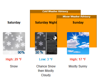
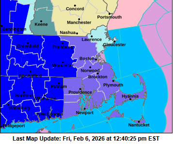
BOS has advisories up, WWA for the CWA east of ORH county, Watch for Essex County. But because of the hierarchy of products, the watch is behind the cold weather advisory for Essex County, so it doesn't show up there. I think they coded the times wrong, too, they're showing the WWA for Sunday (the Watch is timed correctly).
-
They said in their AFD that they were waiting for the hi res models to come in this morning. Given the trends they'll probably put up WWAs across the region, and maybe even a WSW for Essex County.
-
The surface low on Thursday at 00Z went from the benchmark at 06Z to YBG at 12Z. What's 600 miles between friends/model runs.


