
alex
-
Posts
4,656 -
Joined
-
Last visited
Content Type
Profiles
Blogs
Forums
American Weather
Media Demo
Store
Gallery
Everything posted by alex
-
I don't know if it technically is, but it's pretty much a blizzard here. You know it's bad when the ski resort shuts down completely.
-
Ripping. Can’t wait for the upslope. Synoptic makes me anxious lol
-
Pounding here too, but the wind is also very strong which is annoying. Nothing on the trees lol. Still, great for the glades!
-
It’s just absolutely ripping out there, which is a bit unexpected given the potential for downsloping, but the wind is also very strong so hard to tell accumulations
-
I don't know, 2021 has scarred us. We can't seem to get more than a couple of inches at a time or a pack >7"
-
The wildcard, as always, will be what happens after the storm. It seems that it's a lot easier to predict synoptic totals than it is to predict upslope
-
My stake is at 5"; went out skiing and the conditions are just fantastic. It's really amazing how little snow you can get good skiing on lol. 6" would pretty much double that! Granted, I don't do LE but those 5" you can walk on without any problem, it's definitely not the same as what you get with a single 5" storm
-
Mine has 8-15. I'd be happy with 6
-
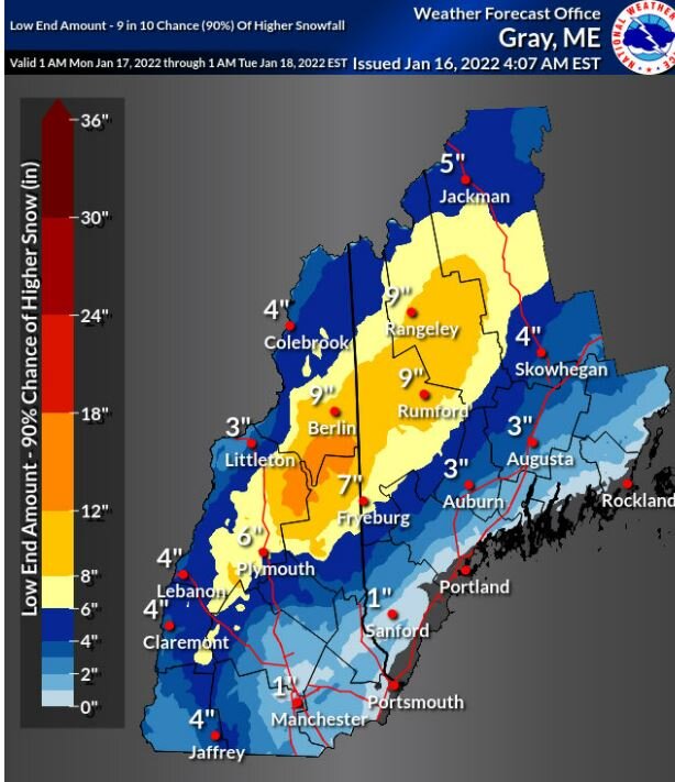
-23. Pedestrian Leery of my location for this upcoming storm, even though the P&C forecast calls for 8-15". The mountains mean business - both with upslope and downslope, but then again, a minor difference in wind direction can have a huge impact so it's always so hard to tell what a storm will end up doing. I remember one of my first winters here a Nor'easter delivered about 4 feet of snow, 12 or so from the synoptic which seemed a bit of a let-down, and then a wallop of upslope and never ending wrap-around. Not suggesting this will happen in any way, but the topography makes an accurate prediction very, very hard. Either way, I'm confident and excited that Attitash and Wildcat will get a good dump; got an Epic pass in addition to my usual Bretton Woods pass and I'd like to use it somewhere other than Stowe! But also excited to ski Stowe later this coming week. I love NNE. It ALL feels like home lol. Anyways. This is not bad for a "low end chance".
-
-23 so it didn’t drop too much further
-

Monitoring a potential important TV to East Coastal storm: Jan 17
alex replied to Typhoon Tip's topic in New England
They do not. Bretton Woods is owned by Omni; they’ve been struggling with staffing (restaurants not open to the public is a big one for instance, and Fabyans has been closed for 2 years due to lack of staffing), but the mountain ops team is a pretty devoted bunch and the guy who runs the resort has been around since well before the acquisition, so that probably helps -
-20 and still dropping
-
-20 and dropping
-
Already down to -16. Gonna be a cold one
-
Not sure I believe that 1.5” of rain would improve ski options but certainly any snow and sleet will. Amazing how much the 1-2” of sleet we got last weekend helped! Skiing has been really good this week and the heavy stuff made it possible to ski some of the glades even with thin cover.
-
Down below 0
-
@powderfreakare there any decent beginner/intermediate glades in Stowe? My kids comfortably do all the glades here (well some better than others), but of course it’s a mellow mountain although they seem to handle the steeper ones better than I do. One cool thing here is that they are marked as blue/black/double black so you know what you’re getting into. Any intermediate glades in Stowe that would be good to try?
-
Expecting the usual downsloping/shadowing for the first part of the storm, then the fun stuff. Hopefully it won’t disappoint like most things this year! Headed to Stowe next week so it’d be good to have good conditions there. Wasn’t Great last time and the family is like - why are we skiing here again??? Need to change their mind, but they’re spoiled
-
-14 already. Not bad
-
You’re a brave one!
-
Would be about time... not that I believe anything at this range
-
Somewhere around -37. I really don't need to see that again; spend 2 days rescuing people whose cars wouldn't start, plus a variety of frozen pipes
-
May the odds be ever in your favor...
-
Snowing. Tiny weenie flakes
-
0.7 overnight


