cheese007
-
Posts
1,637 -
Joined
-
Last visited
Content Type
Profiles
Blogs
Forums
American Weather
Media Demo
Store
Gallery
Everything posted by cheese007
-
Warm nose seems to have nuked this setup per NWS. Like clockwork
-
It's amazing how close DFW comes to a decent event only for temps to end up juuuust warm enough for snow not to fall. Still an outside chance something falls tonight and it's not even technically winter yet
-
Hmmmmmmmmmmm
-
TV mets already hyping this event. Naturally the potential snow line is just north of Dallas lmao
-
So tired of 33 degrees and raining. So, so tired...
-
15% contour added for parts of NTX up into Oklahoma on Black Friday. Not looking forward to it after what happened during the last event...
-
Feels like that has happened a lot the past 5 years
-
NOAA winter forecast is out. If you're a NTX sniow fsn have I got somr bad news for you: https://www.climate.gov/news-features/videos/noaas-2019-20-winter-outlook-temperature-precipitation-and-drought
-
SPC put out a 15% contour for D4 stretching from Kansas into the DFW metro
-
Hoping you're right
-
Does anyone have any thoughts on winter for NTX? Hoping DFW can break its record snowless streak
-
Plains States Observations and Discussion Thread
cheese007 replied to lookingnorth's topic in Central/Western States
Tornado touched down in Sioux Falls last night: https://www.google.com/amp/s/www.nbcnews.com/news/amp/ncna1052246 -
I'd definitely be double and triple checking any econ data between now and November 2020
-
"The party told you to reject the evidence of your eyes and ears. It was their final, most essential command."
-
You're talking about a president who's only guiding principles are "get power" and "minorities bad." Unfortunately, a sizeable chunk of the country thinks the same way. If anything lies like this make him seem *more* appealing
-
Would be wild of this somehow made landfall on the Georgia coast. Iirc that area is a bit of a climotolagical hole when it comes to hurricanes
-
Nasty looking line of storms on its way past the Red River. Will be interesting to watch
-
Been missing the rain so this morning's showers are a very welcome sight
-
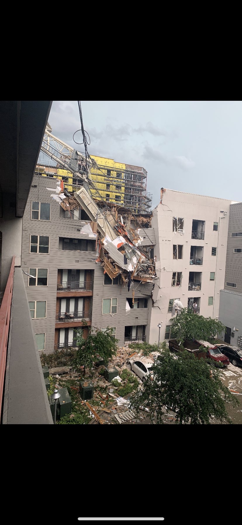
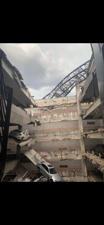
Crane was knocked over by the winds in Dallss and fell on an apartment


-
Central/Western Medium-Long Range Discussion
cheese007 replied to andyhb's topic in Central/Western States
Tomorrow marks two years since the last high-risk day. Wonder if we'll break the streak in the next couple weeks or go for a record-long streak in 20? -
Central/Western Medium-Long Range Discussion
cheese007 replied to andyhb's topic in Central/Western States
D6 risk contour added -
Guess we got the icy surprise after all. As for the weekend system, it seems that the moisture will clear out before temps have a chance to drop below freezing, with Monday and Tuesday being bone dry. Unless we get a spring break surprise again this winter is effectively a wrap EDIT: WWA Just extended until noon. Maybe a long day ahead of us
-
Already at freezing here in Dallas. May be in for a surprise during the morning commute? EDIT: well its gonna be cold enough now but apparently things are drying out as well. Precip or cold: pick one
-
I'm expecting the usual "35 and pouring outside" we've been getting this winter and last
-
Website does the same to me on mobile