ShawnEastTN
-
Posts
1,951 -
Joined
-
Last visited
Content Type
Profiles
Blogs
Forums
American Weather
Media Demo
Store
Gallery
Everything posted by ShawnEastTN
-
January 15th-17th 2024 Arctic Blast/Snow Event
ShawnEastTN replied to John1122's topic in Tennessee Valley
Yep I'm right across the river from Spring City and I'm measuring 9 inches. -
January 15th-17th 2024 Arctic Blast/Snow Event
ShawnEastTN replied to John1122's topic in Tennessee Valley
Just when I've seen the heaviest, it increases more. Heavy goose feathers. -
January 15th-17th 2024 Arctic Blast/Snow Event
ShawnEastTN replied to John1122's topic in Tennessee Valley
Scratch what I said earlier the heavier precip seems to be bringing my temp down now. Down to 27 which I haven't been since about 630AM. -
January 15th-17th 2024 Arctic Blast/Snow Event
ShawnEastTN replied to John1122's topic in Tennessee Valley
My temp hasn't changed at all still 28, but had some heavy goose feathers stepped back outside to find it was goose feathers with some sleet mixed in. Wild! -
January 15th-17th 2024 Arctic Blast/Snow Event
ShawnEastTN replied to John1122's topic in Tennessee Valley
Agree 100% -
January 15th-17th 2024 Arctic Blast/Snow Event
ShawnEastTN replied to John1122's topic in Tennessee Valley
Biggest flakes and I think the heaviest rate I've had so far. Visibility is greatly reduced. Just unbelievable. Think I'm starting to get under those returns coming out of Huntsville. -
January 15th-17th 2024 Arctic Blast/Snow Event
ShawnEastTN replied to John1122's topic in Tennessee Valley
I was just thinking I cannot recall a storm IMBY that has snowed continuously for more than the Blizzard of 93 where I live. Where I live it snowed during the blizzard for about 16 hours. It started snowing here at 8PM roughly last night and if still snowing at 4 PM this will pass the longest duration snowfall for where I live. -
January 15th-17th 2024 Arctic Blast/Snow Event
ShawnEastTN replied to John1122's topic in Tennessee Valley
My flake size has increased too, was a little worried that meant I was getting close to the rain/snow line, but my temp is still frozen at 28/29 all day. Wonder if the SPC update is starting to take effect? -
January 15th-17th 2024 Arctic Blast/Snow Event
ShawnEastTN replied to John1122's topic in Tennessee Valley
You are right you sure did, but you included my house in that special strip, so all good by me. Seriously though you called it before it even started snowing. -
January 15th-17th 2024 Arctic Blast/Snow Event
ShawnEastTN replied to John1122's topic in Tennessee Valley
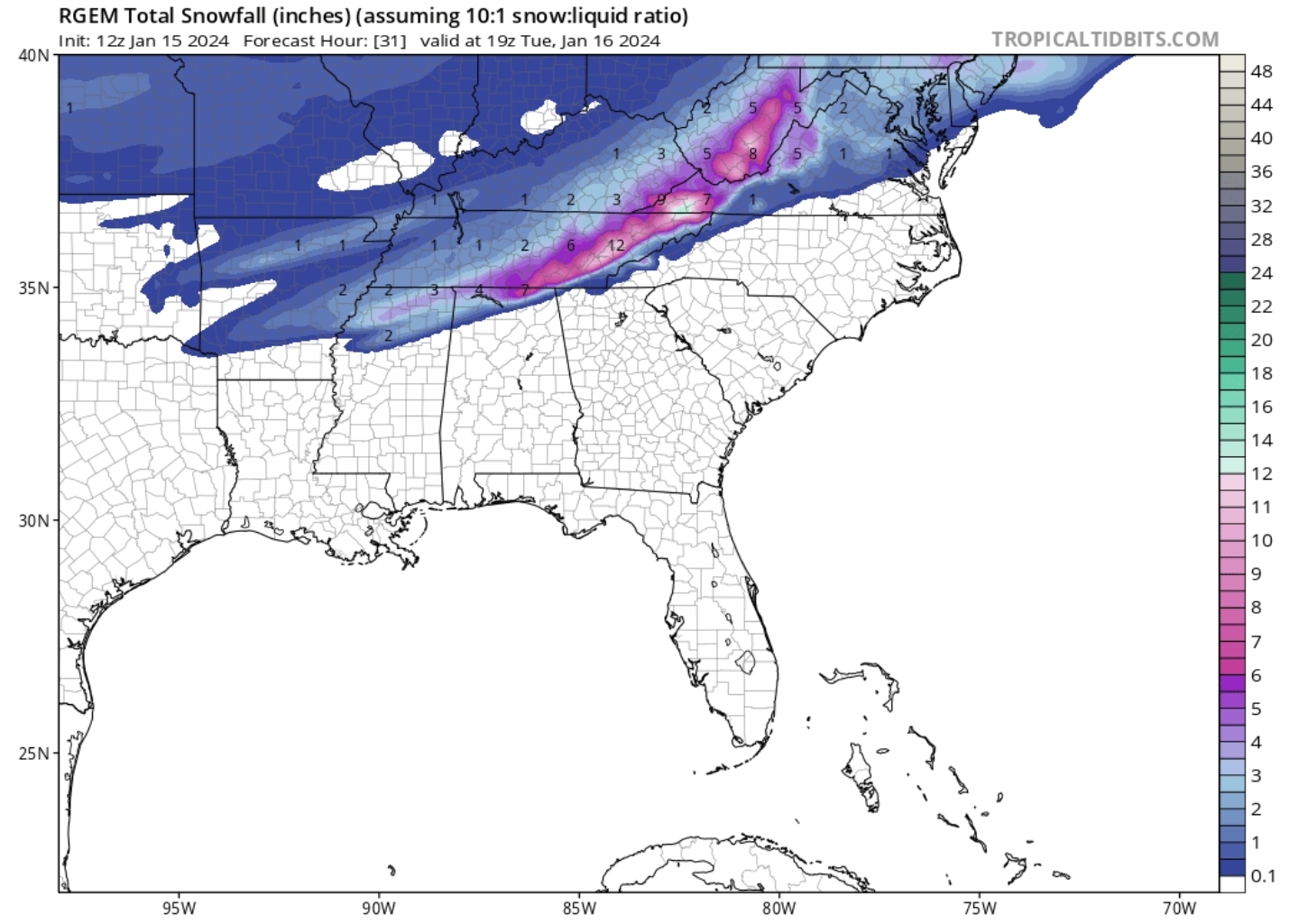
Just can't get over how much is still upstream. Hytop looks like a Christmas tree, all heading NE towards plateau and East Tennessee. -
January 15th-17th 2024 Arctic Blast/Snow Event
ShawnEastTN replied to John1122's topic in Tennessee Valley
That line is mine. I call dibs. -
January 15th-17th 2024 Arctic Blast/Snow Event
ShawnEastTN replied to John1122's topic in Tennessee Valley
Let the upward adjustments commence. Lol -
January 15th-17th 2024 Arctic Blast/Snow Event
ShawnEastTN replied to John1122's topic in Tennessee Valley
Weather Channel has someone broadcasting from Broadway and I was stunned it snowing as hard as it was. Nashville going to come out really well I think. -
January 15th-17th 2024 Arctic Blast/Snow Event
ShawnEastTN replied to John1122's topic in Tennessee Valley
That really really sucks man. -
January 15th-17th 2024 Arctic Blast/Snow Event
ShawnEastTN replied to John1122's topic in Tennessee Valley
Really sucks that you aren't getting it. Maybe you'll still score if the cold can make it to that side of the valley before all is said and done. Still hours of upstream precip. If that Storm prediction center mesoscale update holds true maybe forcing might help in your area to bring down temps. -
January 15th-17th 2024 Arctic Blast/Snow Event
ShawnEastTN replied to John1122's topic in Tennessee Valley
Crossed over 5" now. Well on my way to 6".

-
January 15th-17th 2024 Arctic Blast/Snow Event
ShawnEastTN replied to John1122's topic in Tennessee Valley
Right I really wonder what was going on behind the scenes. -
January 15th-17th 2024 Arctic Blast/Snow Event
ShawnEastTN replied to John1122's topic in Tennessee Valley
Looks safe to say WVLTs 2-3" accumulation for me and Knoxville is a complete bust, especially since most in that 2-3" forecast still have about 10 to 12 hours of snowfall to go. Really surprised they downplayed this event so much when they surely saw guidance. -
January 15th-17th 2024 Arctic Blast/Snow Event
ShawnEastTN replied to John1122's topic in Tennessee Valley
One of the things I'm really impressed by this morning is how fast these tiny flakes are piling up. With the flakes so small it's deceiving when looking outside. It looks a lot lighter a snow than it really is. -
January 15th-17th 2024 Arctic Blast/Snow Event
ShawnEastTN replied to John1122's topic in Tennessee Valley
Still coming down at a great clip, temp hasn't budged from 27 degrees, little over 4 inches now. -
January 15th-17th 2024 Arctic Blast/Snow Event
ShawnEastTN replied to John1122's topic in Tennessee Valley
My road which is a secondary state highway was brined yesterday, scraped and salted by TDOT at 730 this morning. -
January 15th-17th 2024 Arctic Blast/Snow Event
ShawnEastTN replied to John1122's topic in Tennessee Valley
Closing in on 3" Northern Meigs on the Roane line. View into the woods behind my house. Flakes are small mostly but coming down at a good clip, my phone camera isn't good at picking them up though -
January 15th-17th 2024 Arctic Blast/Snow Event
ShawnEastTN replied to John1122's topic in Tennessee Valley
Ok heaviest snow so far IMBY. Much heavier than last night. If I can keep these rates I can believe an additional 6" or 7" on top of my 2" from last night/early morning. -
January 15th-17th 2024 Arctic Blast/Snow Event
ShawnEastTN replied to John1122's topic in Tennessee Valley
Yeah I suspect as the day goes along pavements will start to get covered. The ground temp is radiating through pavement keeping just a bit warmer, but suspect as time goes on and heavier snow moves in and temps stay below freezing those surfaces will start to freeze. -
January 15th-17th 2024 Arctic Blast/Snow Event
ShawnEastTN replied to John1122's topic in Tennessee Valley
Interesting I'm under the lighter stuff on your image on the northern edge of your image like heading toward Knoxville and it's snowing as hard as it did during the night last night and seems to be slowly picking up. I'll be at 2" probably within the hour. 1.75" of that occurred during the night. I wonder what your temp and dewpoint are where you are located.