

backedgeapproaching
-
Posts
3,771 -
Joined
-
Last visited
Content Type
Profiles
Blogs
Forums
American Weather
Media Demo
Store
Gallery
Posts posted by backedgeapproaching
-
-
Up in Essex Junction for a soccer tourney all weekend. No shade and a scorcher for kids and parents alike. Honestly enjoyed last weekends tournament with fleece blankets and hats more I think. ..lol.
-
11 hours ago, powderfreak said:
Watch out. The Bears are getting smarter. Very educated bears around here. They have always been smart... our trash is in a so-called "bear proof" contraption but a mama bear dismantled it last week and spread trash everywhere while my wife watched a cub run around the yard. That's business as usual. But now they have been opening doors.
Lately on the Stowe Front Porch Forum have been numerous posts about bears opening doors and letting themselves into places.
Here's two consecutive posts about bears opening car doors. Then a friend on instagram has a video of a bear trying to open a shed door.
These animals are hilarious
 . Black bears are like racoons mixed with pigs. Very resourceful, crafty, and will eat anything but aren't hunters, only scavengers.
This animal in the video (I only showed a screen shot) is literally trying to turn the knob and open the door. These creatures are smart.

https://video.nest.com/clip/801114b066444ddfa5da007d4b7a8a1a.mp4
https://video.nest.com/clip/3a859ca2effd4724b69c1df80784ed4e.mp4
I forgot to take in my Feeder on Monday night and had one come to the back of the house, which has happened many times. What is interesting is that the Bear is so delicate with the Feeder, he just sucks the seeds like a vaccuum it seems, the holes are pretty small where the seed comes out. The Feeder itself is still the exact same shape it was before he got to it, not like he smashed it into pieces and then ate the seeds-seems to have some experience with these feeders---lol.
The second clip is funny, dude just pops a squat on the lawn enjoying his feast..ha.
-
 2
2
-
 2
2
-
-
22 minutes ago, Sey-Mour Snow said:
Pretty much
Without even looking at my data, that jives with the feel of what has been going on here in SVT.
Every rain event seems to be .14"-- barely wetting the ground under trees. Wouldn't mind some dews to maybe get some storms at least.
-
Yea, that is pretty crazy. You knew it was a mortal lock though of there being multiple rescues this weekend.
-
31 minutes ago, BrianW said:
My hydrangeas look terrible this year. I think it's because they were showing leaves in like early March this year and then they got hit with some cold.
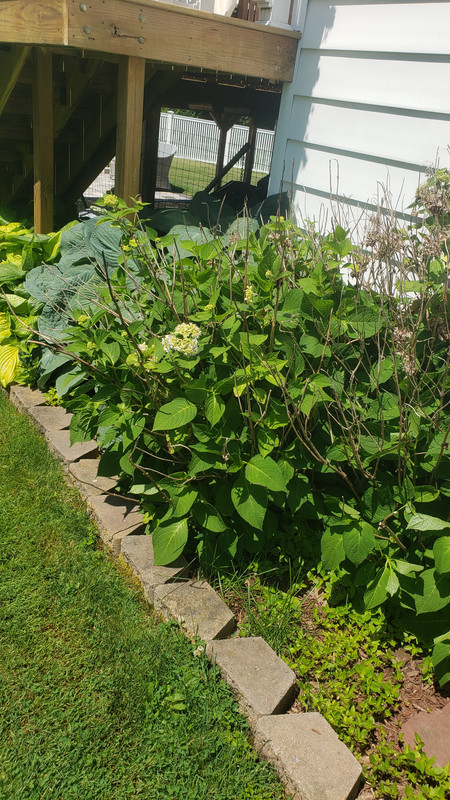
Could be. Those types of Hydrangeas that bloom on old wood never look good here(obviously a lot warmer where you are climate wise), they always seem to get winter damage or some type of spring frost/freeze issue.
My in laws have 2 or 3, not sure what variety, but I have rarely seen anything but a random flower or two, many years nothing. I just stick with Panicle and Smooth Hydrangeas that look good every year regardless of winter/spring conditions.
-
Big soccer tournament being held in Manchester this weekend that my daughter is playing in, everyone bundled in hats, fleece blankets, hot chocolate's, warm tea's, coffee's...lol.
-
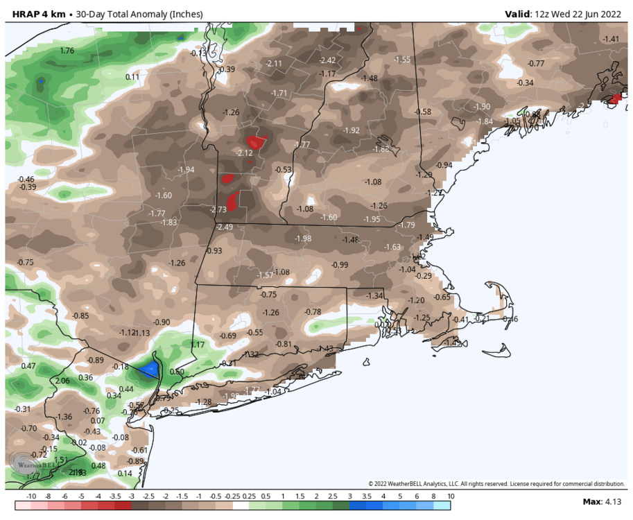
We are firmly on to Deer Fly season, they have been out for a little while now. Still some lingering black flies though too. I only ever remember worrying about mosquitoes growing up in SEPA. It really is ridiculous up here with the bugs...lol.
Serious rain shield in effect here..no rain for 15 days and then only .19" last night.
-
2 hours ago, CoastalWx said:
So you can open the window too apparently? How does that work if you have a screen?
Just like any window AC, you have to take screen out if it's not a sliding screen. My screen slides up, but is still unusable with this. Basically you can open window, but there won't be any screen. Unless you jimmy rigged something I guess.
-
1
-
-
19 minutes ago, Ginx snewx said:
Just immediately look up the manual and go step by step. Not really difficult for a new unit. Basically set outside bracket and extension arms. Looking forward to it. May buy 2 more this week after testing 1. Question for those with multiple. Can you control more than 1 with App. That feature was a seller for me as we are not home a lot and I need to keep the pups cool especially big boy who hates heat. Being a St Bernard Husky it's understandable. Will sleep in the snow at 0⁰ though. Dog like owner I guess.

Yea Steve, I have all 4 units on the app and can control them individually.
-
20 minutes ago, CoastalWx said:
What does tedious mean? I can get angry when I do that stuff lol.
Ha, me too. I watched youtube videos. Honestly, they do have a nice straight forward easy to understand system for install, but its not the 30 second set it and forget of my old units.
-
18 minutes ago, BrianW said:
Those Midea units have absolutely stunning efficiency. Variable capacity inverter DC driven compressors in a window unit. Its basically a mini split in a window unit.
Yea, that is basically what I read as well.
I pretty sure have posted before about how inefficient some of those portable units can be, what a difference when I got rid of my ratty 9K portable and went to the 12K Midea.
-
1 hour ago, CoastalWx said:
Let me know how those work. How did you find out about the rebate?
I have a 12K, 10K and two 8K's. I was coming from 3 old crappy Walmart units and a 15 year old portable unit. They really are unbelievably quiet. My window units were 5K and portable 9K, so it was upgrade in every sense for me. It is really nice to be able to be out all day and use the app and have run them for a few hours so it is cool when you get home. I know alot of window units now have wifi, but this was a change for me.
I think SJones or someone mentioned that is kind of nice to have the extra light as well, they actually look pretty nice from the inside aesthetically. I wouldn't say they are difficult to install, but a bit tedious. I am definitely happy with them considering what I was coming from, total night and day.
-
16 minutes ago, mreaves said:
When I googled Midea U shaped AC it popped up at the top. The State of VT has a utility company that is solely focused on energy efficiency. They give a pretty big range of rebates on appliances, HVAC products etc. I got an $800 rebate a few years ago when I installed a hybrid water heater.
I had no idea about that rebate until you posted that last night. I bought 4 of those suckers last year, guess time to get my $400.
-
1
-
-
9 minutes ago, Patriot21 said:
81 when I got home at 4pm. Down to 59 at 9pm and I'm pretty surprised it cooled down so quickly. Got the windows open with box fan blowing in the night air. Hung out outside until dusk when little flying insects started getting too annoying. Weather-wise felt great though
Wow, pretty quick drop to 59F by 9pm. You might be the coolest spot in NNE right now..or one of. Outside of some spot right on the water.
69F here.
-
1 hour ago, powderfreak said:
That seems like a lot. Efficiency Vermont does some decent rebates, though no where near as good as they were just 2-3 years ago. We are doing one condenser and three heads for $9k. Needing two condensers though likely is a big step up as the heads aren’t *that* much more to add. I know once over like 1500-1700 square feet you’ll max out one.
Friends who have done it said it helped a lot this past winter with heating prices. Still need to burn oil or propane from all the fake cold nights, but really helped them in shoulder season late fall and early spring… like the Nov/March stuff.
Judging by some of the responses here, does seem a little high, maybe I could find something closer to 20K. He said something like, "We're not the cheapest, but we are the best". Ha. I guess I kind of went in a little blind not doing a ton of research on overall cost and didn't factor in the pretty high labor costs.
-
3 hours ago, Chrisrotary12 said:
Just drove through neighborhoods. Lawns cut this week already starting to brown it appears.
Yep, I got one cut in this year and my lawn is starting to brown in spots. I don't even think some of it came out of dormancy from winter--just straight from that tan /brown winter color to that dry/drought brown color...
-
1 hour ago, Damage In Tolland said:
Looking at 16-17K for the splits. Buddy of mine from HS doing it . Said you still need oil heat in the cold winter months, but months like Nov/ Dec and April you can get away with no heat
Just installed all new windows in whole house in Morch which was 14k
How many wall mounted? I got a quote for 5 wall mounted and 2 outside condenser units and think it was 25-26K. I guess had a little sticker shock, so I am sticking with the Midea's I bought last year for now...lol.
Granted, that was only 1 quote, I didn't totally shop around, but figured other would be in that neighborhood, even if a cheaper.
-
The NNE time honored tradition of black fly season has commenced in this area of SVT. Today was the first day they were noticeably annoying.
-
 2
2
-
-
Epitome of a late season snow map..

-
16 minutes ago, wkd said:
If you look at the bag's application instructions regarding how much fertilizer to apply per 1000 sq ft or how many square ft the bag will cover, you will find that the amount of nitrogen applied will be close to the same.
I don't have the bags so I don't know. You may be right the amount applied could be similar based on how many sq feet the bag says it covers. Maybe the 30-0-5 just covers more area and the amount applied could be similar to the 19-0-7. Depends of spreader settings and number of factors I guess. I don't ever use those Combo Fert and Dimension products personally.
The only true way to determine the Nitrogen would be to see the labels.
-
1 hour ago, Lava Rock said:
which Lesco Dimension should I use, the 19-0-7 or 30-0-5?
I would use the 19-0-7 just because I don't think you need to drop that much nitrogen in spring (the 30 number in the 30-0-5).
-
4
-
-
2 hours ago, tamarack said:
Still had 27" at the stake here on 4/9/08. The winter of SWFE swarms.
When I was looking at this last night figured you were probably still buried with your retention.

-
1
-
-
It definitely seems to be a combination of cost and "VT character". The cost is probably the overwhelming factor though.
https://www.treehugger.com/why-one-vermont-town-tearing-asphalt-instead-repairing-potholes-4867361
Just the name of this website says it all
.
I like this snippet from the article:
Back in 2008, the New York Times reported that a “citizens’ uprising” was borne in the town of Brookfield, just south of Montpelier, when officials announced plans to pave a half-mile stretch of dirt road. Mortified by the prospect of the road in question being desecrated with asphalt, town residents banded together and fought back. The road was never paved. At the time, Vermont boasted 6,000 miles of paved road — and 8,000 miles of unpaved roads.
-
@powderfreakand @PhineasC---Nice guys! I will probably get a quote done in the next few weeks to see the cost. My house gets zero shade in mid summer and I hate any dews above 58F..lol. I run my window ACs all the time in the summer, I need it icy to sleep and just be comfortable in general.
-
3
-


June pattern and forecast discussion
in New England
Posted
Normally ENY and SVT are halfway decent for storms by NE standards, what a snoozer for June. Month long chamber weather.