

backedgeapproaching
-
Posts
3,783 -
Joined
-
Last visited
Content Type
Profiles
Blogs
Forums
American Weather
Media Demo
Store
Gallery
Posts posted by backedgeapproaching
-
-
5 minutes ago, Damage In Tolland said:
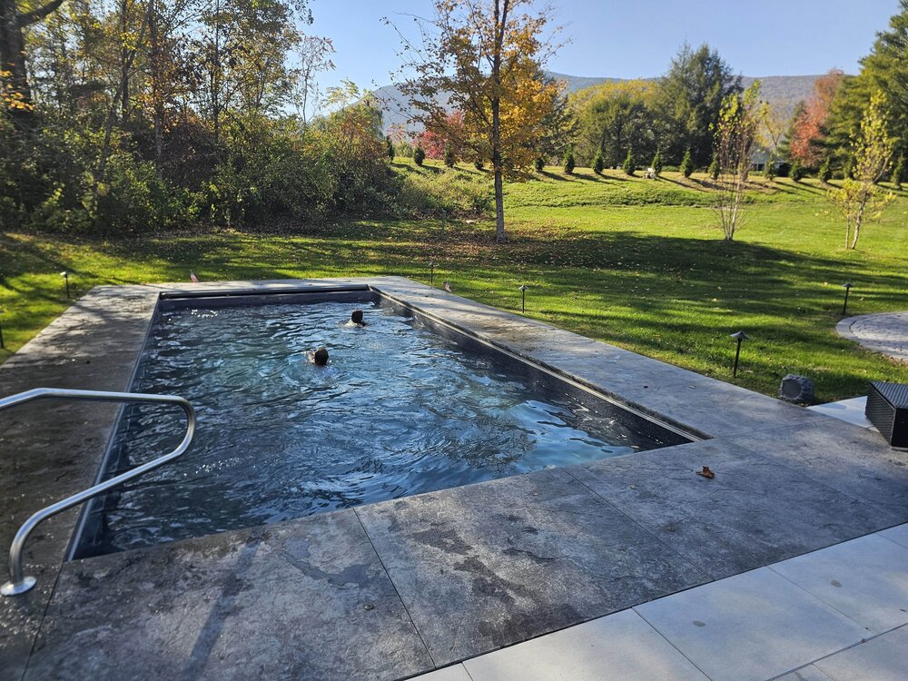
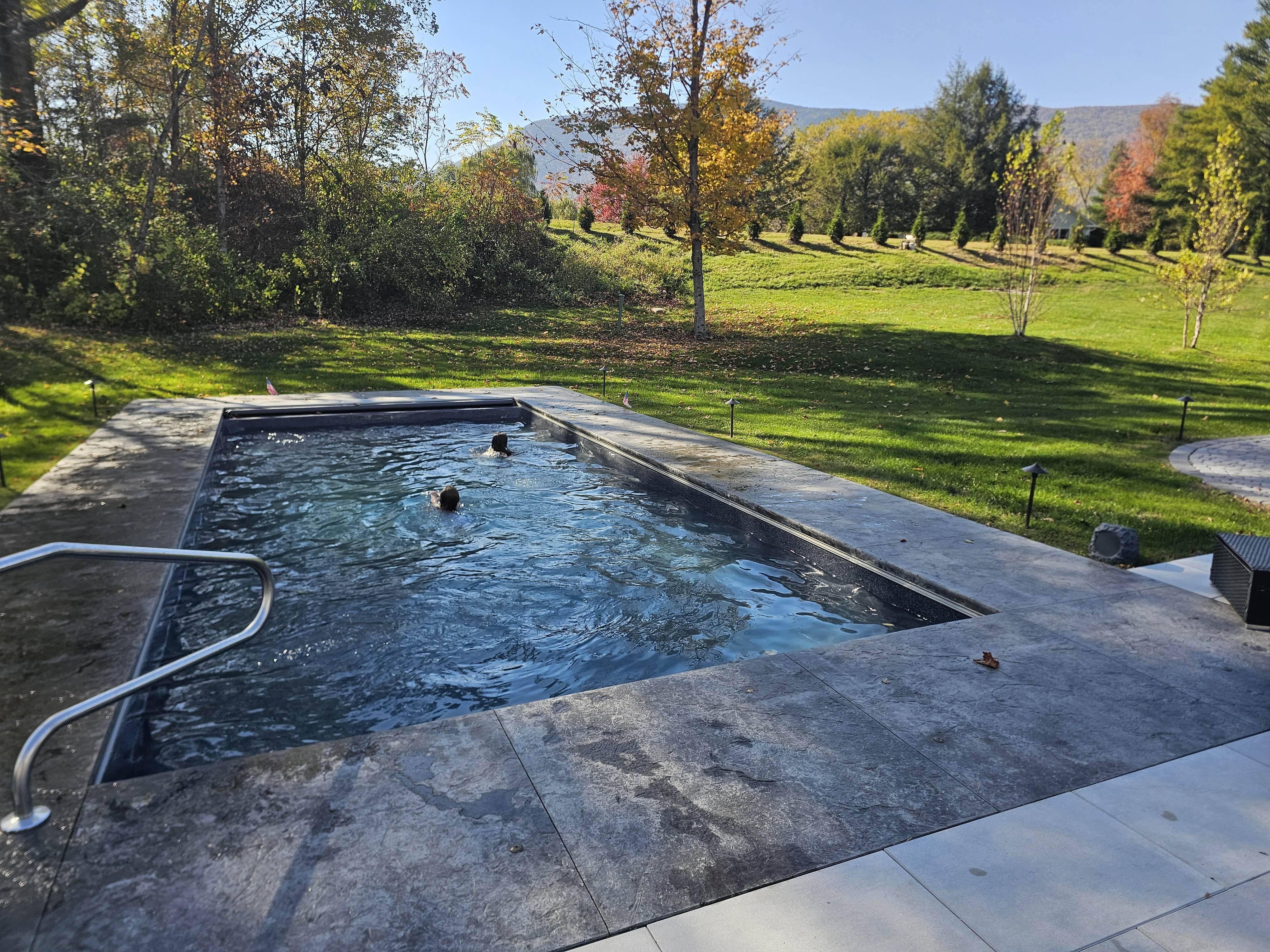
Deep summer look and vibe there . Can’t be too many inground pools in the entire state of VT . Much less Central VT
SVT, but no definitely not. I know 2 people total I think that have them.
-
 2
2
-
-
4 hours ago, CoastalWx said:
Love how warm seasons keep expanding.
ACATT will have two days to enjoy before it warms again.
We pool in VT in OCT..
-
8
-
 1
1
-
-
3 hours ago, powderfreak said:
It’s so early, it has to be drought related. I’ve said it a few times but was shocked in Mt Snow area like 10 days ago.
Later up here but town is looking meh with a lot of leaf drop in spots. Kind of going yellow/gold/rust and falling. The Worcester Range on the east side of town and the Spine was looking decent, in the right lighting.
I think it has to be drought related. I noticed it even on 89 from like Mreaves area down through Brookfield and the high terrain there is past peak too.
Oh, its 100% drought induced. The Taconic range on the west side of Manchester looks half decent, they had some half decent rain comparably speaking.
-
Was in Ludlow today, looks like NOV in spots on the drive over. Okemo 50% Leaf drop the rest brownish some yellow.
Still some rogue patches of color, but I would avoid that area if your looking at leaf peeping this weekend and certainly Columbus day.
-
1
-
-
In case anyone was thinking about planting a willow tree anywhere but an open field
-
 1
1
-
 1
1
-
-
5 minutes ago, powderfreak said:
Yeah it was going real early down there. I was down in Mt Snow area last week… was shocked. Looked like foliage was going to be past peak by 10/1.
Yea, drought turned it quickly this year. Ludlow/Okemo area had some color early Sept, they will almost certainly be past peak by then.
-
1
-
-
Over 3", kicking Stein to curb finally. Foliage borderline peak this weekend in a bunch areas around here.
-
1
-
-
3 hours ago, jbenedet said:
Went to wentworth greenhouse in Rollinsford to pick up some JG Heat and drought mix to reseed the lawn. Found out they carry everything except that. Spoke to them directly about it and they said the brown areas would come back; it’s just stressed. I said no, it’s BARE after thatching. What I need is a mix that won’t get scorched.
I dunno what this buyer is doing but my areas most in need of reseeding are the hottest patches with most direct sun. That also should be the case for most. I get over 8 hours of direct sun in these parts even in August. JG heat and drought is the only seed rated to withstand 100F. People need to realize that in prolonged direct sun, at peak diurnal ISR, unshaded areas in your lawn can get near these temps. That’s what the scorching is telling you…
Also, guy, it’s getting warmer here…
Anyway I went to a local competitor and reseeded with what I needed to be ready for next years onslaught of 90+ clear weather days…
I think you have to be ready for it still to go brown under similar conditions in the upcoming years. It may be heat tolerant to 100F which means less chance of it actually dying,not necessarily staying green without irrigation. It will still go dormant. I think they are marketing this for areas in the south of here where 95-100 happens every summer for long periods of time, and where they actually will have die off because of high temps/humidity. Like you mentioned, its getting warmer here, so i think the choice makes sense, just rain or supplemental irrigation will still be needed.
-
13 hours ago, dendrite said:
Steiner Bros racking up the rain tonight while I enjoy my 0.00”
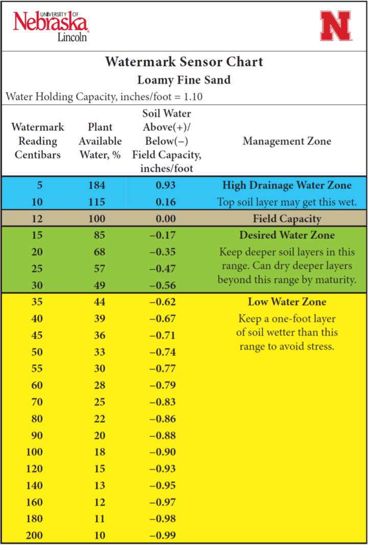
Soil moisture has been around 80cb. That’s about as dry as I’ve seen it here.

Im guessing the NAM is completely lost regarding Wed? Has a soaker CNE and parts of SNE.
-
Saw 2 trees down on houses right down the street from me, power out, pretty nasty. Debris everywhere. TL and torrential downpours as well.
-
3
-
-
Might have been a little thicker last week, but still total crap and pretty smokey, let's get this out of here. Almost forget what clean air looks like looking at a somewhat recent smoke free pic.

-
10
-
-
1 hour ago, mreaves said:
Yea, I saw that..oof. I took mine apart as much as I could and did a bleach cleaning and let it dry. I think every window AC prob has some type of issue with water and some mold, but yea looks like a design flaw.
-
1
-
-
4 hours ago, TauntonBlizzard2013 said:
Why am I having subtle brown spots showing up all over my lawn? They were hard to see at first, but more noticeable now
Would need pics to make any educated guess.
-
On 6/8/2025 at 5:50 PM, HIPPYVALLEY said:
Is there a reason why my neighbor would be mowing his lawn every 2 to 3 days?
He’s only 60 and retired so it could just boredom but maybe there is a good reason for mowing that frequently?
i’m not going to ask him because I find it all a little annoying and he’ll probably detect that in my voice.edit: this is the same person, who will spend Sunny days in late February and early March, snowblowing snow from shady sections of the yard into sunny sections to melt it quicker.
Speaking for myself- I enjoy it. I probably mow every 3-4 days. Lawncare and landscaping are a hobby and are actually enjoyable. Many dread having to cut the lawn on weekends, so they can't imagine why someone would do it more than once a week AT most. I dont do it to "keep up with the Joneses" or one up my neighbor with a meticulous lawn or landscape, I don't have any neighbors--lol. I get a lot of us have different views on what is or isn't a waste of time, resource, money when it comes to this. I do spend a good amount of money(mainly on perennials plants/trees/conifers/etc) and like the yard overall looking nice. Part of that is the lawn too, which I also like freshly cut in combination with all the landscape beds. Certainly get that many on here could not give two craps about it this stuff. I really try to keep the lawn stuff as organic as possible, but will also do soil tests to see what is needed for lawn and plants and make amendments based on that so Im not just throwing stuff down that is not needed.
With all that said, maybe your neighbor is bored out of his mind or hates his wife

-
1
-
2
-
-
After spending 7-8 hours standing in 50F Noreaster rain last weekend at a huge lacrosse tournament here, let's do it again this morning for another big event. Only 4 hours this time
. It's comical at this point.
-
1
-
-
6 hours ago, dendrite said:
I assume this was a bear. Never broke the hook or pulled the feeder down. Just punched, smashed, and ate.
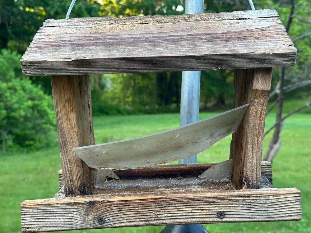
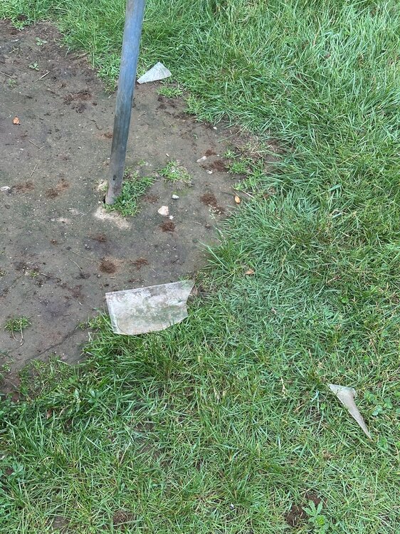
Sounds about right. It seems like they literally suck the seeds like a vacuum out of mine but the feeders are almost always completely left intact.
-
1
-
-
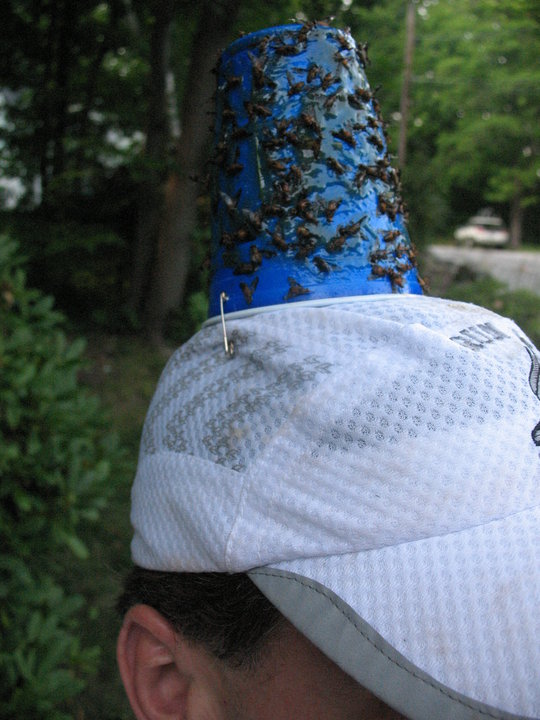
3 minutes ago, metagraphica said:
Black flies are the worst. Nothing deters them. At least with deer flies you can wear a hat with tanglefoot on it that catches them and there other ways to catch them in the yard.
I guess this is the year I try this method...
-
1
-
4
-
-
3 minutes ago, dryslot said:
I was in the garden yesterday and there was a hatch of black flies out there looking for victims.
Had the first baby deer fly land on me today, I would take 100 swarms of black flies over peak Deer Fly season.
-
1
-
-
2 hours ago, HIPPYVALLEY said:
So, we are starting to get a lot of poison ivy, showing up in the back, wooded part of our yard. I’d rather not use toxins to kill it. Has anybody here had any luck with more natural solutions?
I was thinking of mixing up a big batch of sea salt and vinegar to spray it with. I’m pretty sensitive to it so I’m not really interested in putting on gloves and pulling it up myself.Also looking to see if I could borrow some goats for a day or two. I would love to own a pair of goats, but I’m not quite ready for that commitment and they are not easy to contain.
I think the problem with Vinegar is that its mostly a surface kill. It will most likely go brown pretty quick, but I don't think it gets to the roots for a total kill, so it will just come back. Not just poison ivy, but any thing you are trying to get rid of.
I am all ears too for a natural solution that actually works and kills down to the roots.
-
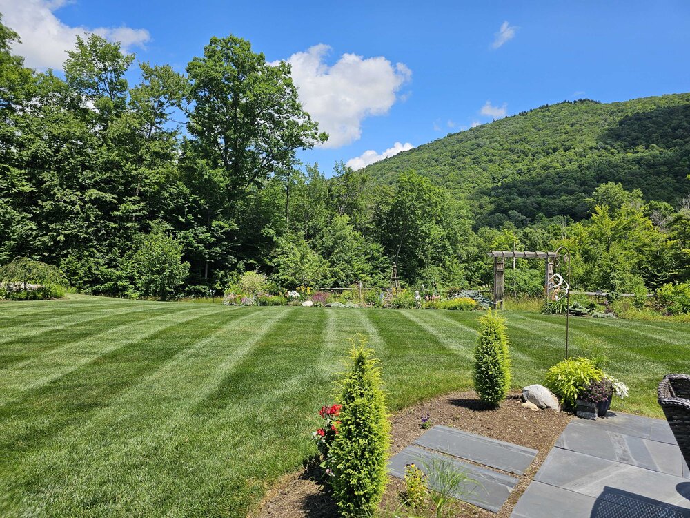
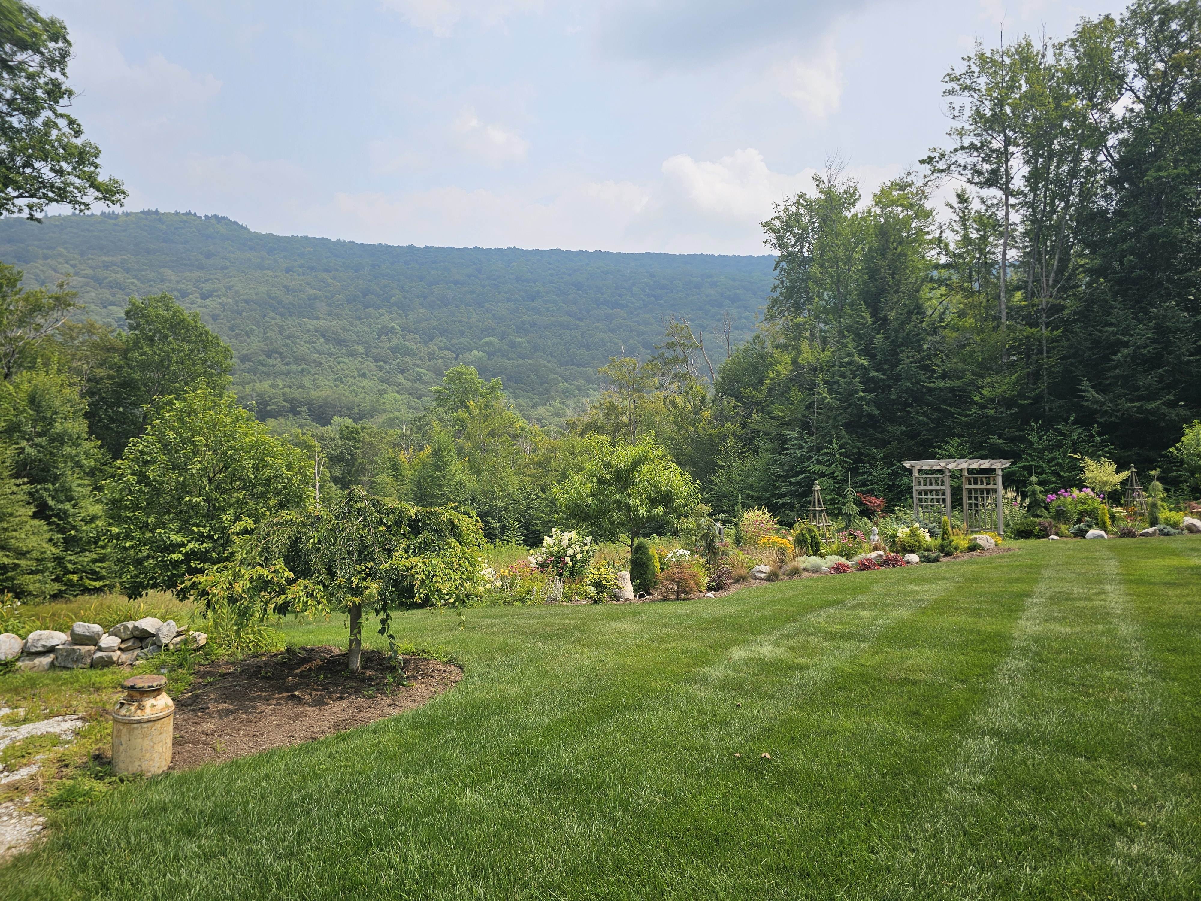
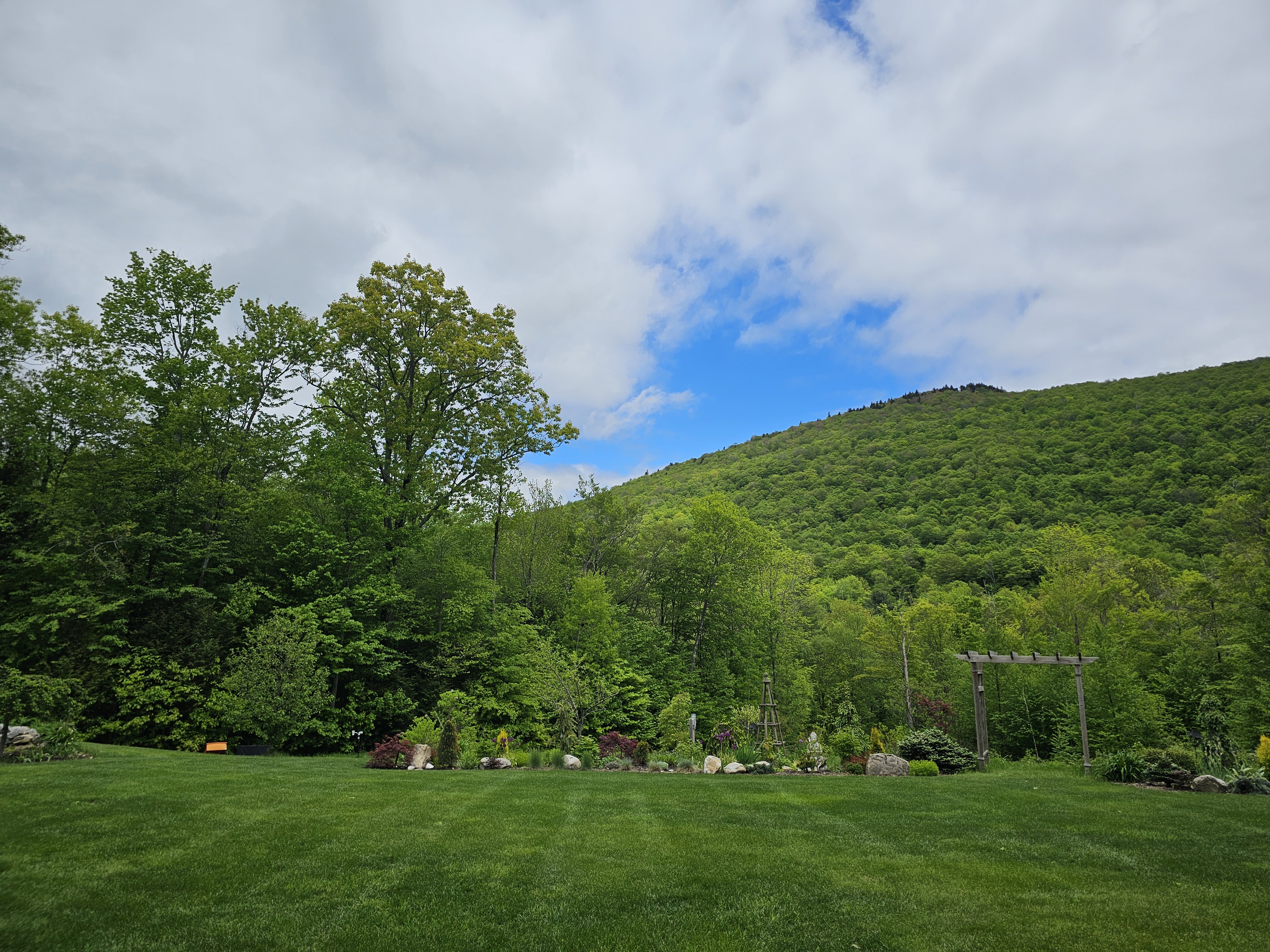
24 minutes ago, CoastalWx said:
What direction is that looking? I love that view.
NE
-
1
-
-
This is the most blue sky I have seen in 8-9 days..
even bright overcast has been a win.

-
6
-
-
35 minutes ago, HoarfrostHubb said:
We had to purchase a portable unit for my mother-in-law's assisted living unit. Pretty nice and inexpensive device that seems to do the job where she is.
Mine was really old and most likely very inefficient so probably skewing my opinion a bit, guessing the 2025 versions are certainly a little better.
-
1
-
-
7 minutes ago, klw said:
Too many lost Yurts to count
Meanwhile I am under a severe warning and a special weather statement, some thunder and pretty solid rain ongoing
I'm up in your neck of the woods on I-91, legit lowest VIS I maybe have ever driven in, literally dark as night/insane rates had to pull off. Crazy CGs and trees swaying. Cars going 10mph.
-
2
-
-
26 minutes ago, bristolri_wx said:
Thanks everyone for the suggestion of the Midea's. I have seen those on Amazon. Is the install as easy as a standard window unit with the U shape of these?
No, definitely more of a learning curve. You don't just pop them in like a standard unit. There is YouTube video that has step by step if you need it. I get them quick now after doing it a season or two.


Spooky Season (October Disco Thread)
in New England
Posted
It was gusting to 50mph yesterday here and it probably took 60% of Oak leaves only, stubborn suckers. At least those that did drop are now blown into NY with that wicked east wind...lol.