

backedgeapproaching
-
Posts
3,679 -
Joined
-
Last visited
Content Type
Profiles
Blogs
Forums
American Weather
Media Demo
Store
Gallery
Posts posted by backedgeapproaching
-
-
2 minutes ago, mahk_webstah said:
Kuchie pushes the heavier band nw. Assuming that is ratios?
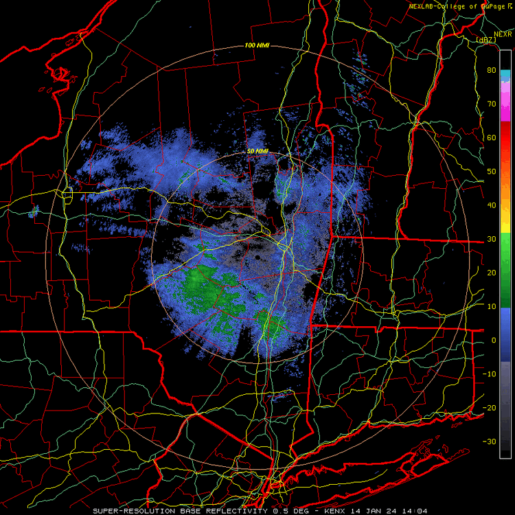
BTV mentioned 15 or 20:1 ratios. Light winds so no fractured dendrites and good lift through the DGZ for a time. Kuchie could verify if there are multiple hours of good snow growth.
-
 1
1
-
-
That might be one of the most balanced state wide corner to corner snow maps I have seen.
-
1
-
-
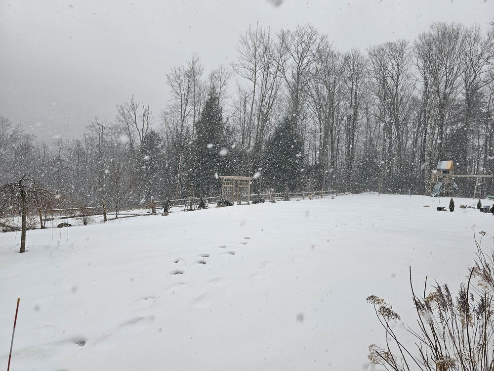
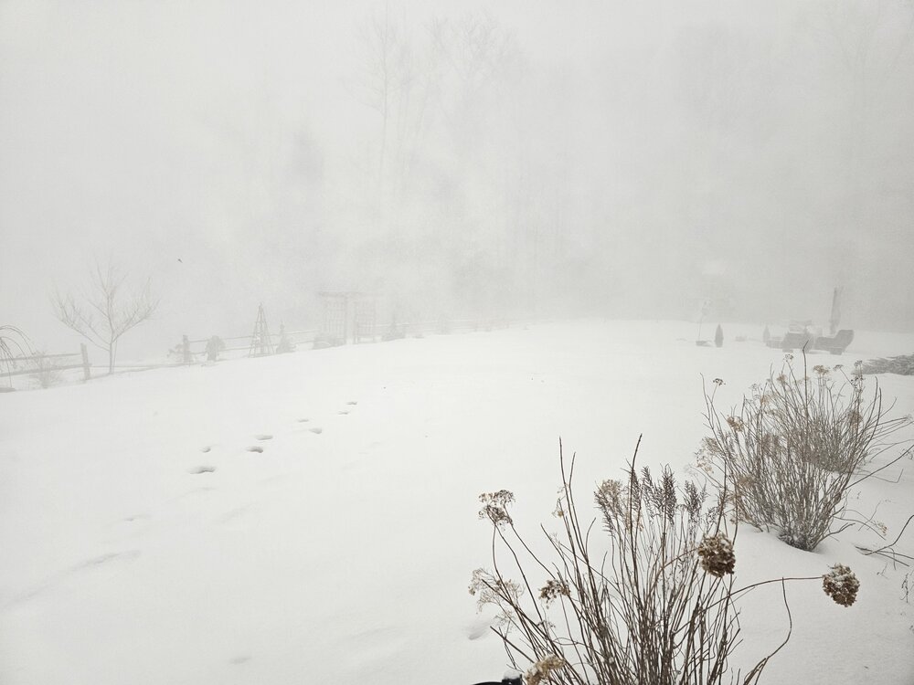
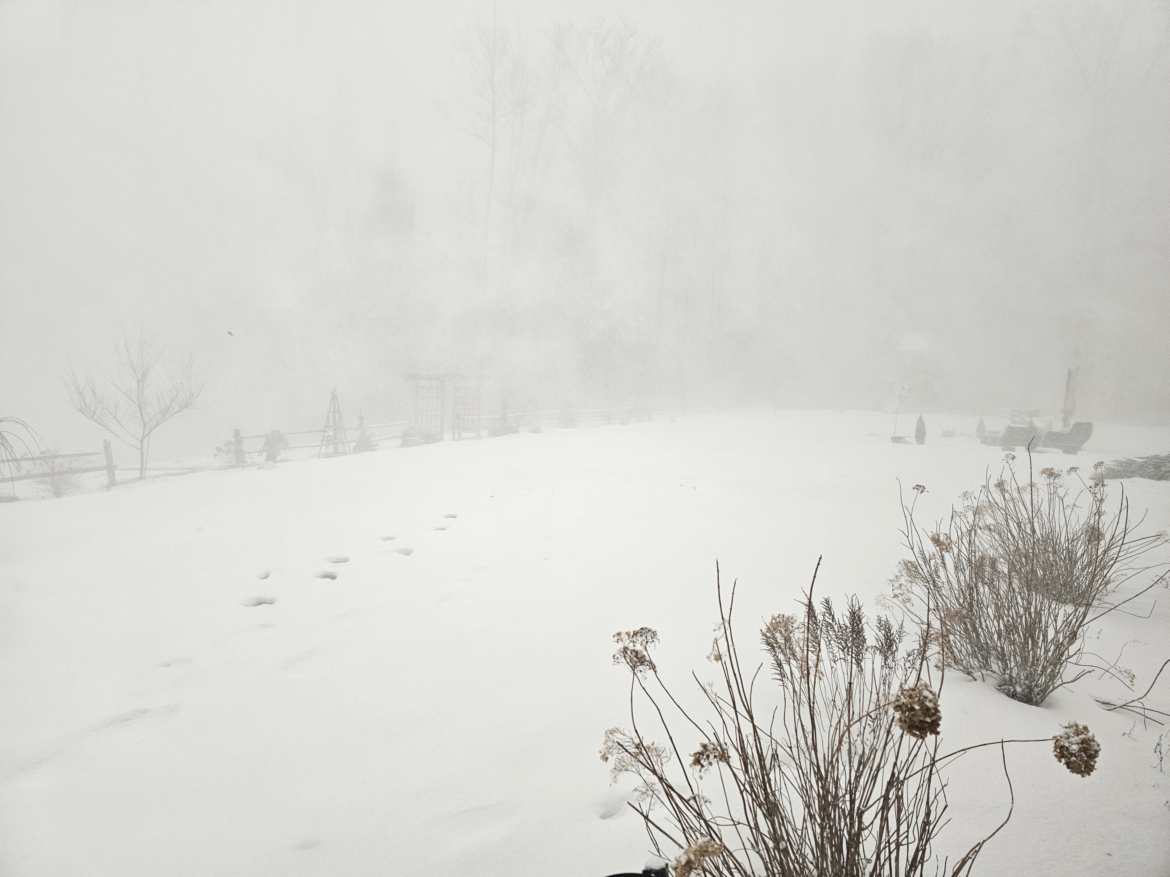
This was close to S+ before the line hit around 30 mins ago.
During squall line
-
8
-
-
S+ with the stuff ahead of the main line. Should be pretty wild when that stuff moves in over next hour.
-
Yep, getting juicy out in CNY racing east.
-
1
-
-
2 hours ago, dendrite said:
2010 was a long lived squall line. That was the one the RSM nailed. This may be a little different if we get a mesolow forming.
Nothing was more epic than that squall that hit KLW's area down through you a few years ago. Wasn't that like an 8" squall? Guess that wasn't a squall line per se either.
-
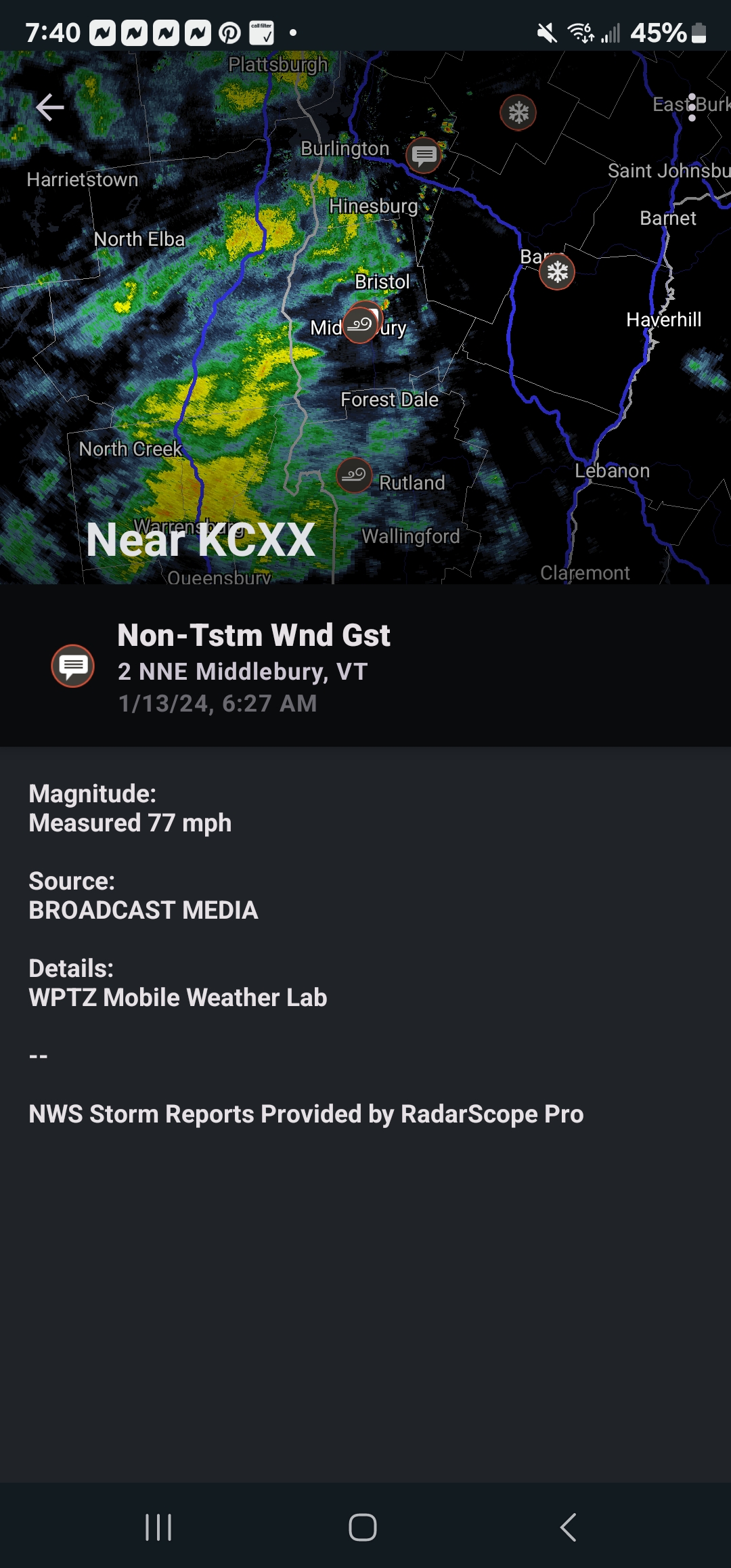
77mph near Middlebury..thats pretty solid.

-
1
-
-
Yea, the radar was really ragged overnight. Picked up just about 2" and gusted to 52mph. Cant imagine even the elavtions in SVT had more than 3-5 based on the radar.
-
7 hours ago, Sandstorm94 said:
Once we get the screamer out of here we can properly track, we hold serve. It is just the 12th of January, we got 7 weeks left
Sent from my SM-S146VL using Tapatalk
That is probbaly what your used to. But March has had the highest average snowfall the past 10 years at my spot. Im in SVT too. Even in Brattleboro winter isn't over in FEB normally.
-
33 minutes ago, STILL N OF PIKE said:
Extremely Similar in location, amounts will in my opinion be 2/3 as much snow due to less QPF .
WPC and HREF are much tamer than Wednesday.
WPC does not have 8”+ progs above 50% anywhereMy guess is 6-9” in Conway and maybe 10 @ Wildcat
Will be interested to see if Bretton woods avoids shadowing
GYX always has some weenie colors on those maps with a more subdued discussion totals , they had 18-24 swath for Wednesday and the only place I saw verify was someone measured within 1-2 miles of Mt Wash summit but they nailed their forecast totals that they had out in the warning areas
It's also a little warmer this time around it seems. So places that were marginal last event will see less because of that and less QPF. As always, good to be In and Up.
Last event here was 6.8", definitely taking the under on that for tonight.
-
5 minutes ago, HIPPYVALLEY said:
You can tell the wind threat on this is minimal because Kevin hasn’t posted.
Looks like another western slopes downslope special in VT, just maybe a little tamer than the other night. Still prob 40-60mph gusts. Everywhere else more meh maybe outside of other downslope areas in NH.
-
7 minutes ago, mreaves said:
We may have reached peak craft beer.
Craft sales continue to struggle in 2023, NBWA March Beer Purchasers’ Index confirms
Transitioning to the Bourbon craze over the past 1-2 years? My brother-in-law is crazy about finding rare bourbons and deals on good stuff.
-
3
-
-
1 hour ago, alex said:
LOL! Hey, we should get some credit for it being already all shoveled. This stuff is heart attack material - but if you don't do it now, it's not gonna be fun later
1 hour ago, Lava Rock said:cover that grille. the door is ri
 pped off too
Lol, thats great. My grill door blew off the last wind storm the other week, I literally cant find it..

-
The Cocorahs guy near me at 1900' had 12.7" which pretty much came in like 5-6 hours. Pretty impressive front end thump.
-
4 minutes ago, Froude said:
Had a quick inch of snow followed by some sleet and now flipped to liquid in the west side foothills. Our house is very exposed to the SE so I don't love these big downslope wind events. Happy the white pines are all on the lee side at least.
Similar down here..full exposed to the SE. I'm only like 500ft feet from the spine though, so it just races down during bad events. So far, not too bad, just lows 40s gust.
-
43 minutes ago, dmcginvt said:
Im seeing approx half the intensity as valentines 2007 here in VT subjectively of course. But I know 2 in an hour when I see it. And Im close to seeing it, it's literally pouring. got a time lapse on hoping to prove it.
Measured 1.7" in 45 minutes earlier, so yes definitely close to 2 an hour.
Winds lessend a bit here and it been ripping for 4+ hours now. Were close to changeover, Temp up 30.3F.
ALY had 1-2" for here. Got 5" down now--big flakes still for now.
-
1
-
-
9 minutes ago, #NoPoles said:
Full on blizzard conditions in Bretton Woods. I had to drive home from North Conway. I said a lot of prayers. I honestly was so scared. Couldn't see the road at all. And I drove that for over an hour and made it through Crawford Notch. The wind is swirling and making snownadoes and just giant snow swirls. The snow is accumulating in speed bump like structures on the road so drive was super bumpy. At times I had to in the road and wait for a tiny amount of visibility to come back. Most of the time I could only see about 5 feet in front of me, and then I had a few moments of absolute zero visibility where I just stopped and had to wait because the visibility had dropped to zero.
I had a similar drive here earlier,.only mine was like 5-10 minutes..lol. But it was nasty out there for sure..hard to see anything.
-
1
-
-
14 minutes ago, HIPPYVALLEY said:
Wow. Calm down in Greenfield. Snow is falling straight down.
Pretty normal here with a strong Low cutting. SE LLJ ripping down W/NW facing slopes of the higher terrain. Meso's showing this pretty well. Does seem to look worse in NVT, so see how it goes overnight up there.
-
1
-
-
26.8F. Pretty low VIS--gusts to 42mph already- snowing sideways with a mini ground blizz---lol
-
1
-
-
13 minutes ago, ariof said:
The Prospect webcam on Route 9 in SVT shows SN and their weather station has their temp at 24 having come down from 26.
https://prospectmountain.com/conditions/
I believe this is within a couple of miles of Chez Mitch.
My temp dropped a bit from 30.2F down to 27.8F now. Bouts of-SN and already little breezy--27MPH on Davis. Lets see what the overnight brings--going to rip here I think.
-
2
-
-
9 hours ago, DavisStraight said:
That guy made 16 million just doing that damn commercial.
Maybe he is a lurker and closet snow weenie? He has been living in Manchester VT full time for at least a decade I think...
-
1 hour ago, mreaves said:
Somehow, I missed ALY's PNS for VT. Like you said, the valley got porked.
VERMONT

...Bennington County...
  Landgrove               8.0   441 PM  1/07  WeatherNet6
  5 NW Readsboro          7.3   230 PM  1/07  Trained Spotter
  Bennington              3.0   230 PM  1/07  Amateur Radio

...Windham County...
  6 SSW Guilford         10.5   430 PM  1/07  CoCoRaHS
  Newfane                 9.0   345 PM  1/07  Public
  Athens                  7.7   520 PM  1/07  Elevation 1010ft
  East Dummerston         5.6   445 PM  1/07  Trained Spotter
Full ALY for SVT. As expected Eastern Areas did better in Windham County
VERMONT

...Bennington County...
  Peru                    8.6   700 AM  1/08  Co-Op Observer
  Landgrove               8.0   940 PM  1/07  WeatherNet6
  5 NNE Stamford          7.5   400 PM  1/07  CoCoRaHS
  3 ENE Manchester        6.9   700 AM  1/08  CoCoRaHS
  West Arlington          4.0   418 AM  1/08  WeatherNet6

...Windham County...
  2 N East Dover         11.7   631 AM  1/08  CoCoRaHS
  6 SSW Guilford         10.5   700 AM  1/08  CoCoRaHS
  6 SSW Guilford         10.5   430 PM  1/07  CoCoRaHS
  Newfane                 9.0   345 PM  1/07  Public
  6 W West Brattleboro    8.9   900 AM  1/08  Co-Op Observer
  2 NNE Marlboro          8.9   800 AM  1/08  CoCoRaHS
  1 WNW Wilmington        8.0   550 AM  1/08  CoCoRaHS
  Athens                  7.7   520 PM  1/07  Elevation 1010ft
  Townshend               7.5   600 PM  1/07  Trained Spotter
  1 S Brattleboro         7.4   700 AM  1/08  CoCoRaHS
  1 NNE Rockingham        6.1   700 AM  1/08  CoCoRaHS
  East Dummerston         5.6   445 PM  1/07  Trained Spotter

&&
-
The valley here down through Bennington got totally porked.
The deep east flow downslope along with never getting into any good FGEN lift resulted in not much accum.
Ended with 6.9" here. Center of town Manchester prob 3-5" and heading south prob 2" in Arlington and 1" or less in Bennington. There was a little upslope that came through last night that added a little in those spots.
-
14 minutes ago, powderfreak said:
To me the different is the big storms. Bennington seems to be left out more in the big ticket east flow events. But they'll do fine from the west and the lighter events, lake effect streamers, etc.
100%. DDH does get a decent amount of nickel and dime upslope/streamers to get to their average, but it's events like this that are killer.

At least it's something - Jan 16th Snow/Sleet/Ice OBS Thread
in New England
Posted
We were stuck in no man's land in SVT between the PF and crew band and the SE stuff most of the day. Pretty pedestrian rates and meh snow growth for big part of the day.
Made up some ground with some 20-30:1 fluff this evening finished at 5.5"