

backedgeapproaching
-
Posts
3,678 -
Joined
-
Last visited
Content Type
Profiles
Blogs
Forums
American Weather
Media Demo
Store
Gallery
Posts posted by backedgeapproaching
-
-
Heavy heavy yard work today. Valleys FTW right now with regard to greenup/perennials popping up/etc compared to the mountain towns still flicking snow fleas off their snowpack. Nice late season skiing though.
Mitch still buried at 2k while at 1k in the valley south hills getting pretty green.

-
4 hours ago, Brewbeer said:
So how much lime to folks put down? The instructions on the bag indicated that a "maintenance" level of lime application is 20-40 pounds per 1,000 sq.ft. Thoughts?
That's probably dolomitic lime. If you do need lime you can with Calcitic Lime which is normally more appropriate for home lawns, which is much less # per 1000sq ft. The per bag price might be higher, but it covers much more sq footage.
Like IrishRob said, a soil test would truly confirm if you need it or not.
Here is an example or a bag that covers 5000sq ft.
-
 1
1
-
-
8 minutes ago, IrishRob17 said:
You really should test the soil, testers are cheap. Everyone just assumes because you have moss you need lime and that's not always the case.
Yep, exactly. Without a soil test, no way to know for sure. Generally speaking soil in the northeast is acidic, but doesn't mean every single yard is.
-
1
-
-
2 minutes ago, CoastalWx said:
Thank You. Forsythia are already starting in some spots. That's all I am saying.
Tropics--wow
-
1
-
-
Here's the problem, a lot of the weeds you see in early spring are actually winter annuals--they actually germinated in the fall, sit dormant and then take off once the weather warms in April. Pre-emergent wont do anything for those fall germinating weeds like chickweed ,poa annua, bittercress and some other nasty suckers.
Crabgrass is not close to germinating I wouldn't think, but the the guys in SE MA would put down there Pre-Emerg before most on this forum. Toss it down when forsythia bloom, its a decent soil temp indicator.
-
IMO--which I have probably stated in the past--- the best course of action is to be aggressive in the fall with your Fert and if you do that you don't need to do any Spring nitrogen drop. I only do Organic Fert spring/summer and fast release stuff in the fall.
-
2
-
-
Late to the party, but just winding down up here this morning. Final is 18.4"
Just about 50" for the month.


-
2
-
-
23 minutes ago, LongBeachSurfFreak said:
I can’t wait to get back up there tomorrow night. The amount of snow has been nothing short of epic. And that was before this event. How did you do in this one?
14.5" still coming down and should for a good portion of the night. Yep, just amazing conditions right now.
-
1
-
-
15 minutes ago, Ginx snewx said:
Taconics in ENY/W MA have been getting crushed with upslope most of the day. Reminds me of NOV 16 a bit, not the insane totals though as with that one I wouldn't think.
-
1
-
-
31 minutes ago, wxmanmitch said:
8" of new upslope on top of the 7" from yesterday. Very light snow right now, but models have it ramping up again from around 03z to 12z, yielding another 0.5-0.75" of LE. Then it tapers to flurries and light snow showers tomorrow during the day before another round tomorrow night?
Snow growth has been kind of cruddy with lots of small rimed flakes and even pellets at times. Unlike a lot of these upslope events though, there's some good weight to the snow thanks to the deep moisture layer wrapping around our storm.
I'm not buying the 35" storm total report from Woodford. I drove through there today en route to do an errand in Bennington (which was almost a costly mistake as I pulled over to a parking area on the side of route 9 that hadn't been plowed in several hours to let someone pass and got stuck, but luckily I was able to weasel my way out of it). Yes, they have a lot of snow like I do, but I find it hard to believe that there would be a 20" gradient in less than 5 miles at pretty much the exact same longitude and similar elevation. They were west of the meso band that nailed areas just west of I-91 like I was and radar returns haven't been that much different there. Maybe they have a little more, but not 20" more.
Meanwhile Bennington had only about 2-3" that was melting in the March sun angle with temps near 32-33° F. I came back via Williamstown and N. Adams as 9 and 8/100 are tough.
I have seen every report they sent in over the past 3-4 years and quietly questioning the total validity of their numbers. I mean they are always just so outrageous in every single event, like every one. I figured being at the crest there benefits them a ton and it really is an uber weenie spot, but now with you close by you can kind of cross check.
Although Wilmington VT reported 20" over the past 2 days before anything today which falls kind of line with Woodfords-- before the upslope today.
If you do take their reports as accurate, they have had 93" in the past week or so, which is insane.
-
54 minutes ago, wxmanmitch said:
White sandstorm here since the death band is about 20-25 miles east of where it was last time. Probably about 3-4" of new.
Was wondering how it was down there, as its similar but worse here, meh growth and rates. The best western fronto bands pretty far east of here.
3". Sky is actually kind of bright, going to have to make hay on the backside upslope/orographic stuff to get to ALY totals.
-
18 minutes ago, ORH_wxman said:
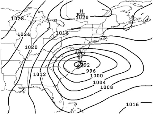
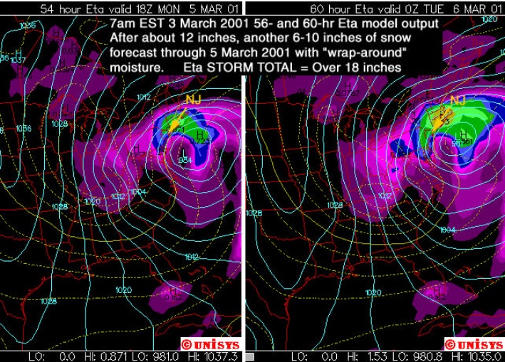
2 more from March 2001...model images....first one is the AVN model and the 2nd one is the ETA model from a Rutgers presentation I believe (hence the focus on NJ)...you can see by the 12z run Saturday morning, the ETA was already crushing SNE...though it was still overdone for the mid-atlantic, but the trend was in full effect by this point (the ETA-X was actually more aggressive in the next panel or two).....you can see how ridiculously far south of AVN is....these are not the same model run...AVN is 12 hours earlier in the cycle, but it's still way south in classic KU position for the M.A.:
You kind of recapped it yesterday, but here is a more detailed account you had posted back in 2011 about the March 01 timetable and recap. Will, please start eating some brain boosting foods to improve your memory..lol.
Here is my detailed recount of the March 4-6, 2001debacle.
There's a lot of "stories" behind it. First off, almost all guidance was going for a monster Mid-Atlantic HECS about 96-108 hours out. Back then the time range beyond 96h meant very little...but models actually did have it further out than that. Only a few model went further. The UKMET, ECMWF and the MRF (the extension of the AVN which is now the GFS all in one package) all called for it. By the time we got to 84 hours out, all models showed it still...basically 2-4 feet for DC-NYC with Boston getting fringed....except the old ETA-x....the old ETA went to 60 hours, but the "ETA-x" was the ETA to 84h which eventually became the NAM (run under the ETA) to 84 hours but is now run under the WRF and not the ETA anymore...ETA has been retired from operational use, only used in the SREF now. That run of the ETA-x had the storm much further north and crushing New England while limiting the snow in the Mid-Atlantic. I believe this was Friday at 12z. Nobody took it seriously as it was the ETA extended beyond its already 60h limit.
The next run at 00z Friday night, the ETA-x showed it again, but the other models held serve....the ECMWF didn't run at 00z back then...only at 12z, so its solution was non-existent. It was the best model back then too like recent years. We were now at 72h out or closer. The 12z runs came out on Saturday morning and they shifted north, limiting the snow for DC (probably from 2-3 feet to about 1-2 feet), but from Wilmington DE northward it was still monstrous except the UKMET shifted slightly north of that, to Philly and northward.
A little side note. The AVN had performed absolutely brilliantly in the other big east coast storm on December 30, 2000 and also on the December 3, 2000 North Carolina/Virginia bust. The ETA hadbeen way too bullish and far west in both events while the AVN schooled it. So a lot of attention and credence was being given the AVN. That was a big factor in the forecast IMHO.
After those Saturday morning runs at 12z (while the ETA showed a huge hit north again at 48-60h now in the operational run)...the forecast was still for a monster M.A. hit. The 12z ECMWF wouldn't come out until around 8pm that evening. It used to come around at that time back then. As 8pm rolled around, the ECMWF all of the sudden jumped way north and agreed with the ETA solution. But most forecasters disregarded it as it had been pretty steadfast before (maybe a burp run?) and the AVN was holding really steady and it had done so well on East Coast storms that winter. By Saturday night, the GGEM started to go north, the AVN held serve once again (having been the model of choice all winter), the ETA went north again taking Philly and nearly NYC out of the huge snow and hammering New England/Boston with a storm like Feb 1978. UKMET I don't recall what happened, but I know the forecast stuck close to the AVN.
Again there was no 00z ECMWF run back then. Only 12z.
By 12z Sunday morning just 24h before the event, the AVN once again gave a monster hit to the mid-atlantic except it shifted a bit north...it was mostly Philly northward. The ETA gave New England a huge HECS again, the GGEM finally went well north...and so did the UKMET. The ECMWF would have to wait until 8pm as usual. Most forecaster were trusting the AVN because it had served them well that winter after the obscene ETA busts and the AVN had nailed two major east coast storms.
When 8pm came in, the writing was on the wall if there was any doubt left. It was way north and took Philly and possibly even NYC out fo the big snows, though NYC was still on the line.
The forecasts started being revived when the 00z AVN came in late that Sunday night and it finally jumped north, but still not far enough....it still gave big snows to Philly (but not historic totals) and historic totals to NYC. I think this is when most operational forecasters knew something was terribly wrong. You have to remember it was so hard to trust any model that winter and the AVN was the best until that point.
That was the first storm that I recall Dave Tolleris (whether you like him or not) came up with the old "EE rule"...when the ETA and ECMWF (both start with "E") agree, you don't go against them. I was lurking on ne.weather back then. When the EC came north to agree with the ETA back on Saturday, he said the M.A. was cooked and got a lot of crap for it on the boards as you can imagine.
That's just my personal recollection of all of that storm. I don't claim for all of it to be 100% accurate, but I usually remember things very vividly, so I think at least most of it is right. There was a lot of controversy and talk amongst the weather people both on ne.weather and the NWS back then. It ended up being a huge interior New England and NY State HECS. Even the models at the last second kind of busted at Boston...only getting 10" while they were forecasted for double that...but the suburbs got all the snow.
Very incredible storm both from a forecasting standpoint and also as a student observer back then when I first learning a lot of the intricacies of forecasting and models.
-
12 years ago. Obscene snow amounts in Maine. I worked this event at Upton but I can't recall why that screw zone occurred in SE CT.
That would be a fun storm on here because most everyone in the forum got in on some 12+action, so there would be a lot less "you stole my snow" posts outside of the screw zones like you said of SE CT, the Cape, and the donut holes near Northampton/Amherst(I think?), and MA/NH border.
-
Read on ALY NWS that ALB had .5" during the meat of the storm while 10-15 miles W/SW the Catskills/helderbergs had 20-40"...rough. Although ALB snagged a few extra inches once winds shifted from E to N.
-
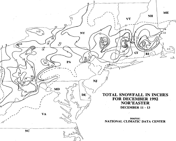
Youngsters like weatherMA and ma_blizzard would have been in nirvana in ORH during Dec 1992 since school was out until Thursday or Friday despite the fact the storm started Friday and ended late Sat night into early Sunday morning.
I know you SNE guys always talk about this storm, I cant seem to find a snowfall map for it. I think it was a big east slopes dump and downsloping pain in the valleys. I have no memory of it since it was a cold rain storm where I grew up in the Mid Atl CP. I thought it was mentioned Will made one, but maybe I'm not remembering that correctly.
EDIT:
Guess I didn't look hard enough, found this one:
-
Very cool -- seems like most of you say that storm and April 97 are the ones that every other storm has to live up to.


9th annual Lawn Thread 2018
in New England
Posted
Pics? Could be a fall germinator that got through your fall weed barrier or germinated before your drop. Hard to say without knowing what it is.