JKEisMan
-
Posts
360 -
Joined
-
Last visited
Content Type
Profiles
Blogs
Forums
American Weather
Media Demo
Store
Gallery
Everything posted by JKEisMan
-
As predicted, kick to the groin for WOR
-
Probably realized it wasn’t enough of a dr no, so reiniting to totally squash hopes.
-
1.5" New Fairfield. Sleet for a good while, then rain/drizzle. Now back to snow.
-
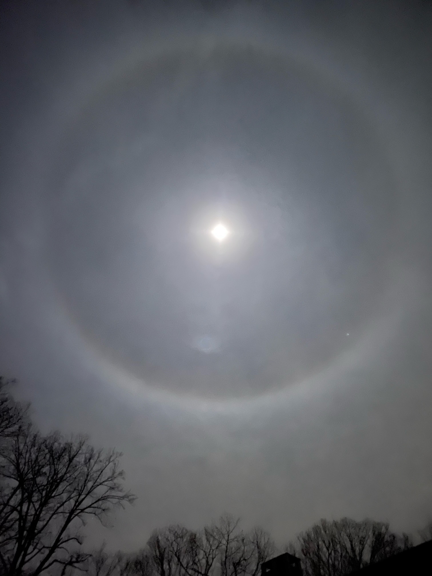
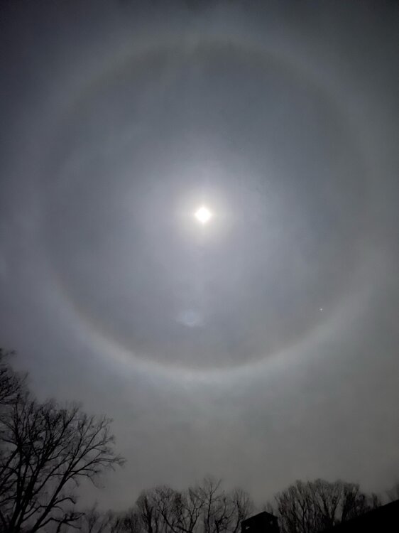
Also nice halo moon.
-
Euro/gfs compromise and we’ll be golden. Even nyc
-
Feb 28th-March 1st long duration Miller B threat
JKEisMan replied to George001's topic in New England
I don't know, but the rgem looked like it was headed in the right direction -
Feb 28th-March 1st long duration Miller B threat
JKEisMan replied to George001's topic in New England
I know it has to do (in part) with how sleet is accounted for, but it's striking how for 18z GFS TT gives WCT a foot of snow and pivotal almost zilch. that's the reason not to rip and read the snow maps edit: oh i see, pivotal counts it as frz rain -- almost an inch of it, haha -
Feb 28th-March 1st long duration Miller B threat
JKEisMan replied to George001's topic in New England
Canadian less impressive. -
Feb 28th-March 1st long duration Miller B threat
JKEisMan replied to George001's topic in New England
Yeah, not a good start to the 0z model runs, but it’s the icon so who cares, right? -
Feb 28th-March 1st long duration Miller B threat
JKEisMan replied to George001's topic in New England
It’s been too long since WCT has stood upon the podium and as of now it looks again as if we’ll be denied a mount. -
Feb 28th-March 1st long duration Miller B threat
JKEisMan replied to George001's topic in New England
-
Days and days of snow. We can only dream.
-
I was mildly hopeful for the upcoming stretch, but the trend this season has been undeniable. This winter has blown its chunks, head stuck in the toilet and fingers trembling on the lever to flush this piece of trash into the abyss.
-
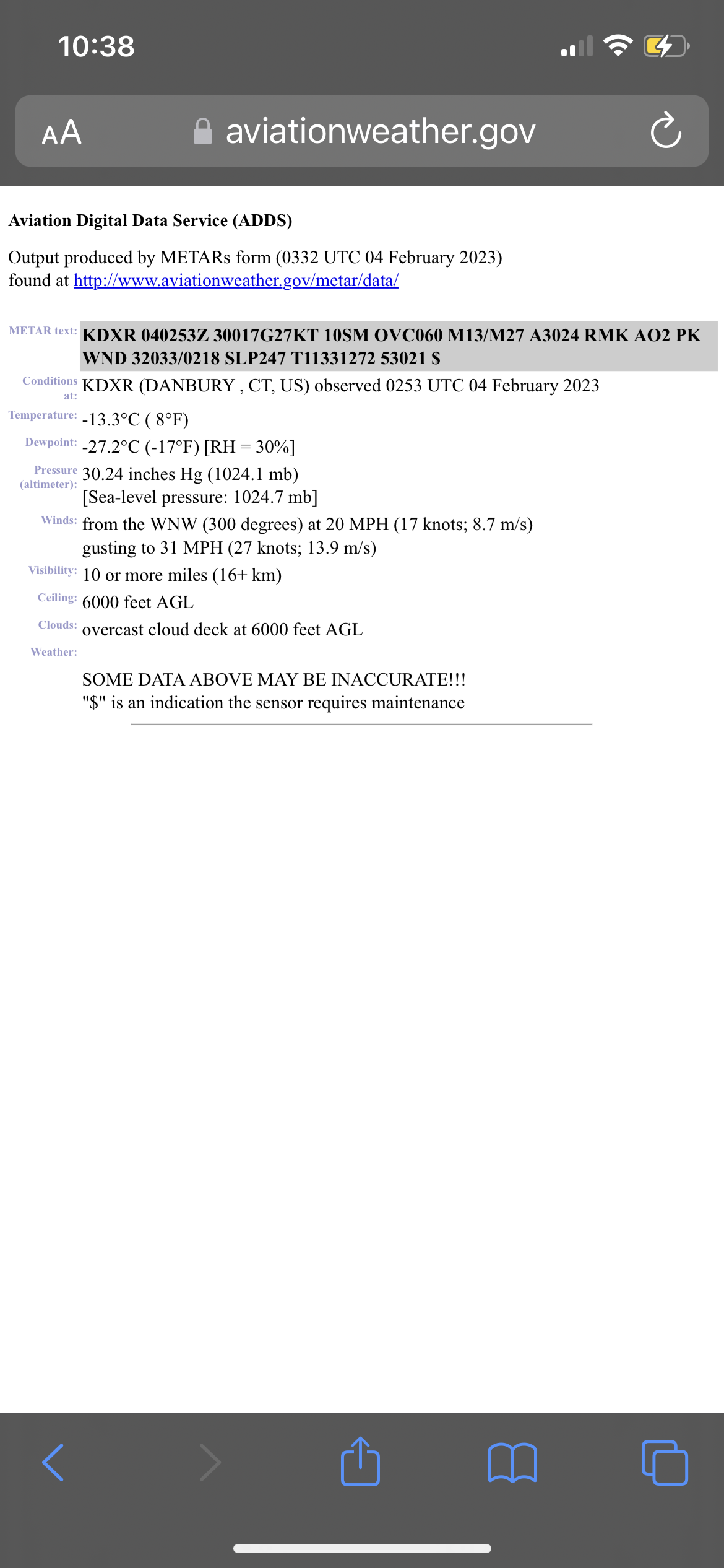
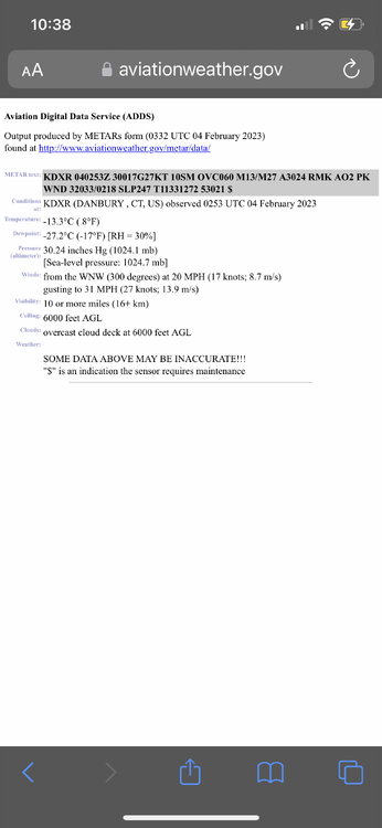
Thanks @dendriteand @BrianW, that’s helpful. I was looking here https://www.aviationweather.gov/metar/data?ids=KDXR&format=decoded&hours=36&taf=off&layout=on and saw a recent -8, which is more in line with other local readings (I have -12 low in New Fairfield one town north). But in general the Kdxr readings look wonky and there is a sensor maintenance warning. I brought it up with @CT Rainlast night but he seemed to dismiss it.
-
@dendrite where’s the best/official place to get that info (where do you get it, if I can ask)? And do you have it for dxr. I see a -8 for dxr but conflicts with other recent obs at that site.Thanks.
-
Which one does not belong? Definitely something wrong at KDXR. Readings used to be good there.
-
Ok. Thanks! They seemed stuck at 8-9 F for a while and then there was the sensor maintenance warning. They’re at 3 now, still seems high relative to other readings around. I’m at -5 F at 800 ft in New Fairfield.
-
@CT Rain is KDXR asos reading accurately- everything else around is at or below zero. Seems there’s a sensor problem?
-
Temperature just started plummeting in New Fairfield , down to -2. Half of town without electricity.
-
Is there some reason OKX didn't include Northern Fairfield and Northern Middlesex in the Wind Chill Warning for CT. It seems they will be as close as the other CT zones (from OKX) in meeting the criteria. If anything, from recent HRRR and RAP, if they're good on temperatures, the axis of cold has shifted a bit west from where earlier modelled. I'm at 8.9 now with 40-50 mph gusts in New Fairfield
-
14.2 in new fairfield, ct with some pretty good gusts
-
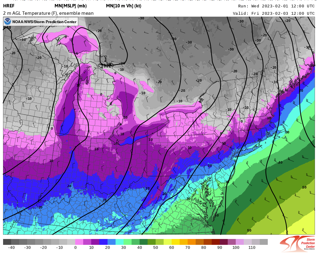
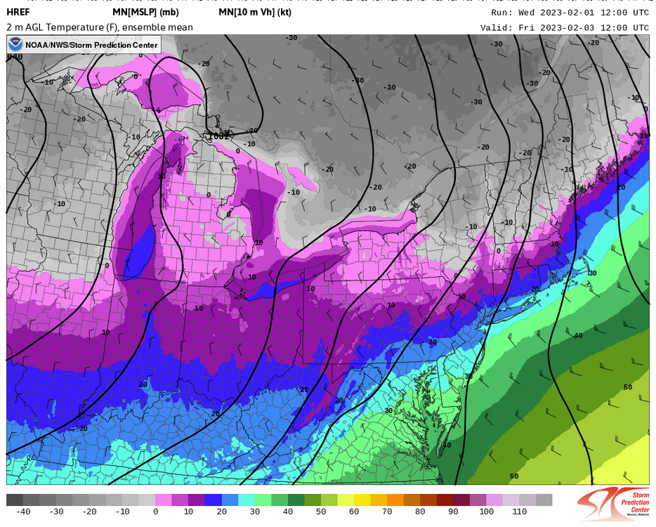
Not sure how the HREF does on temps at the end of its run, but this is mean temp for Friday morning as the cold starts pouring in. Looks pretty cold in NNE.
-
Man this winter blows chunks.
-
Snowing in Cornwall/Goshen, CT according to Mohawk Mt webcam
-
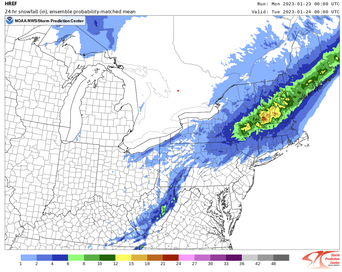
I would gladly take this given the season so far, but skeptical (at least for my neck of the woods) .