JKEisMan
-
Posts
360 -
Joined
-
Last visited
Content Type
Profiles
Blogs
Forums
American Weather
Media Demo
Store
Gallery
Everything posted by JKEisMan
-
The last hurrah? Putting all the eggs in the Tuesday 3/14 basket
JKEisMan replied to Ginx snewx's topic in New England
Goalposts slowly closing … Uh, I mean quickly widening -
March 10-11 light snow threat for SW New England.
JKEisMan replied to Sey-Mour Snow's topic in New England
3” was the final here. Expected more but never got cold enough to really stack up. -
The last hurrah? Putting all the eggs in the Tuesday 3/14 basket
JKEisMan replied to Ginx snewx's topic in New England
Ukie is like 30-40” northern Litchfield up through Berks. Crazy -
March 10-11 light snow threat for SW New England.
JKEisMan replied to Sey-Mour Snow's topic in New England
Right on New Fairfield/Sherman town line, near NY state border. 850’ -
The last hurrah? Putting all the eggs in the Tuesday 3/14 basket
JKEisMan replied to Ginx snewx's topic in New England
CMC would give me March 7-8,2018 redux. 2 feet+. Hopefully more widespread for all. -
March 10-11 light snow threat for SW New England.
JKEisMan replied to Sey-Mour Snow's topic in New England
Starting to stick to everything and accumulate 31.8, but not great flakes. -
March 10-11 light snow threat for SW New England.
JKEisMan replied to Sey-Mour Snow's topic in New England
Pretty much all snow. 32.3 Let’s see if it can accumulate. -
March 10-11 light snow threat for SW New England.
JKEisMan replied to Sey-Mour Snow's topic in New England
Mixing 33.8 -
March 10-11 light snow threat for SW New England.
JKEisMan replied to Sey-Mour Snow's topic in New England
35.3 at 850’ New Fairfield. -
The last hurrah? Putting all the eggs in the Tuesday 3/14 basket
JKEisMan replied to Ginx snewx's topic in New England
loop de loop -
The last hurrah? Putting all the eggs in the Tuesday 3/14 basket
JKEisMan replied to Ginx snewx's topic in New England
I'm worried about west ticks and roasting temps to montreal here's to hoping the euro holds -
The last hurrah? Putting all the eggs in the Tuesday 3/14 basket
JKEisMan replied to Ginx snewx's topic in New England
WCT turn those frowns upside down. Sucks that it's not showing something more regionwide. Of course it won't hold, probably come more west unfortunately. -
March 10-11 light snow threat for SW New England.
JKEisMan replied to Sey-Mour Snow's topic in New England
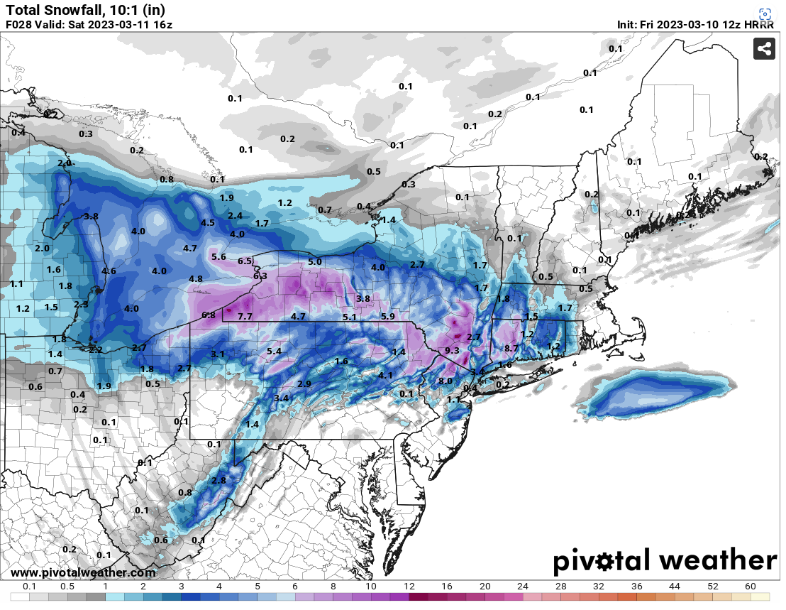
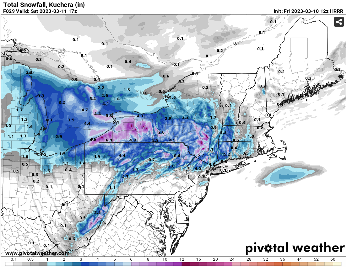
Latest HRRR looking good for WCT

-
The last hurrah? Putting all the eggs in the Tuesday 3/14 basket
JKEisMan replied to Ginx snewx's topic in New England
I think that's very much still on the table. -
March 10-11 light snow threat for SW New England.
JKEisMan replied to Sey-Mour Snow's topic in New England
Hopefully this is just an appetizer out here in western CT before the Tuesday deal and not the main event in terms of snow. -
March 10-11 light snow threat for SW New England.
JKEisMan replied to Sey-Mour Snow's topic in New England
They will need to bump those numbers come this afternoon -
That band just hung over the my head at the border of NY/CT. Legit 26”. Would love to do that again.
-
The last hurrah? Putting all the eggs in the Tuesday 3/14 basket
JKEisMan replied to Ginx snewx's topic in New England
There’s no good cold air source to the north, temps are toasty all the way up to Montreal. -
The last hurrah? Putting all the eggs in the Tuesday 3/14 basket
JKEisMan replied to Ginx snewx's topic in New England
I'm just happy there's something to track at this piont. Let's hope we're still tracking come the weekend. -
The last hurrah? Putting all the eggs in the Tuesday 3/14 basket
JKEisMan replied to Ginx snewx's topic in New England
I would take my chances out here in WCT with that -
The last hurrah? Putting all the eggs in the Tuesday 3/14 basket
JKEisMan replied to Ginx snewx's topic in New England
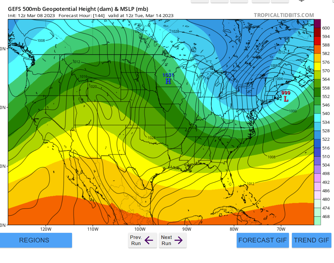
CMC looks good, let's keep it going. GEFS too
-
The last hurrah? Putting all the eggs in the Tuesday 3/14 basket
JKEisMan replied to Ginx snewx's topic in New England
Yeah, that looks good for out here -
All the more reason to lean on ensembles for now
-
Ukie has monster that explodes off the coast and slides SE (for Saturday)
-
Gorgeous. I’m there every other spring/summer for a TSRC (telluride science research center) workshop covering molecular science. Always stay in Mountain Village taking the gondola down to Telluride. Lots of great hiking and biking. Haven’t made it out there for skiing yet but your photos make me want to go :-)