JKEisMan
-
Posts
360 -
Joined
-
Last visited
Content Type
Profiles
Blogs
Forums
American Weather
Media Demo
Store
Gallery
Everything posted by JKEisMan
-
Hours 12-36 of href
-
I think we‘ll see some surprises before tomorrow, hopefully positive. This is a huge storm and setup somewhat outside the norms, not sure the models have a full hold despite the SWFE flavor. We‘ll be in a nowcast mode soon enough.
-
Boo
-
Any indication of how models are doing based on what’s happening out west?
-
Rufus looking like it’s pushing sleet further north too
-
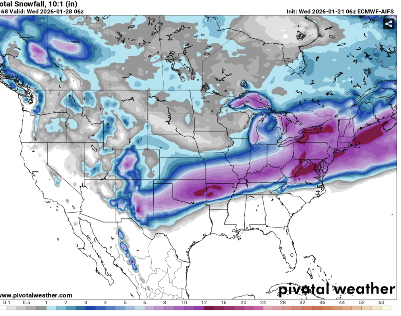
For reference to my above (serious) question. Is the answer we should chuck any snow ratio algorithms, just keep it simple at 10:1? Those ratios are actually higher than Kuchera, which is relevant to my question above. As an aside, I like the way that shows the Housatonic valley and relative orographic enhancement in New Fairfield at the intersection of Putnam, Dutchess, and Fairfield counties.
-
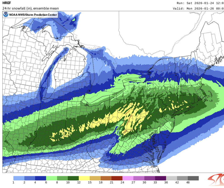
Relevant to the Kuchera numbers - on pivotal HRRR has three snowfall products: total snow, total snow (10:1) and total snow (Kuchera). If you look at total snow, which I assume uses some HRRR based algorithm for snow ratios, it’s actually higher than the Kuchera numbers. Should we not use that?
-
January 2026 regional war/obs/disco thread
JKEisMan replied to Baroclinic Zone's topic in New England
Beautiful -
18z nam blip, will come back to its senses by 0z.
-
Gotta like the enthusiasm in the Albany AFD from this morning. Get your yard sticks in hand The ensembles and the medium range deterministic guidance continues to trend north/northwest with a primary and a secondary coastal low moving along the Mid Atlantic Coast late Sun/Sun night into Mon producing potentially a widespread moderate to heavy accumulating snowfall across eastern NY and western New England. Initially, arctic high pressure /~1040 hPa/ will be over NY and New England Saturday night into Sunday morning with a plethora of arctic air in place. Cold Weather headlines /Cold Weather Advisories and Extreme Cold Warnings/ will likely be needed Sat night/Sun morning for the County Warning Area. An inverted sfc trough associated with with low pressure over the Southeast/Lower MS River Valley will focus some snowfall over the region Sun morning into the afternoon. A secondary low forms near the VA/NC Coast late Sun pm/early Sun evening. The primary low weakens/decays over the Ohio Valley into western PA (associated with the inverted sfc trough), as the secondary coastal low takes control east of NJ and south of Long Island Sun night. The track continues to show less variability and more consensus on the majority of the guidance, as the coastal cyclone slows down Mon morning into the afternoon, which keeps the snow going over the vast majority of the forecast area. The moisture fetch from the Gulf and Atlantic is impressive, as QPF totals are approaching 1.0" over a large portion of the forecast area which with a high snow to liquid ratio may yield heavy/significant snow tallies. A 7th period Winter Storm Watch was discussed and it was decided with WPC and a majority of the collab offices (OKX/BOX/GYX/BTV) to wait another cycle. The bottom line is that an extended period of moderate to heavy snowfall is supported by the NBM with 60-90% probabilities for snow Sun/Sun night into Mon. The latest 48-hr NBM guidance ending 7 pm Mon for >6" of snowfall indicates probabilities of 55-90% across the majority of the forecast with the highest probs from Albany south and east. 48-hr probabilities for >10" of snow for the same 48-hr period ending 7 pm or 00Z/Tue are 40-70%. Maybe have your yard sticks located and ready? The snowfall may potentially impact the Mon morning commute with the heavy snowfall. In the mid and upper level deformation zone to the departing storm system, additional snowfall could continue into Mon afternoon/Mon evening which would add onto the totals! The storm system is still 3-4 days out, but confidence has increased for moderate to major impacts for a moderate to heavy/significant snowfall. Snow to liquid ratios look to be above climatological values (12-20:1) with an arctic air mass in place, as high temps will be in the single digits to mid teens on Sun. Lows will be below zero over the southern Dacks and southern Greens Sun night and single digits over the majority of rest of the region. Highs on Mon only recover into the teens and lower 20s with some single digits over the mtns, as the snow tapers to flurries and snow showers by the Mon night time period. Below normal temps continue into the mid week.
-
Getting that coastal more involved seems a trend this morning. If true not crazy to think someone pulling a two footer out of this
-
6z euro ai looks great. Bump up from 0z
-
6z GEFS has a bunch of members that hang back with stronger lows. So although snow amounts look lower earlier they bump up from the longer duration overall.
-
6z GFS just keeps snowing through all of Monday. Doesn't want to stop.
-
January 2026 regional war/obs/disco thread
JKEisMan replied to Baroclinic Zone's topic in New England
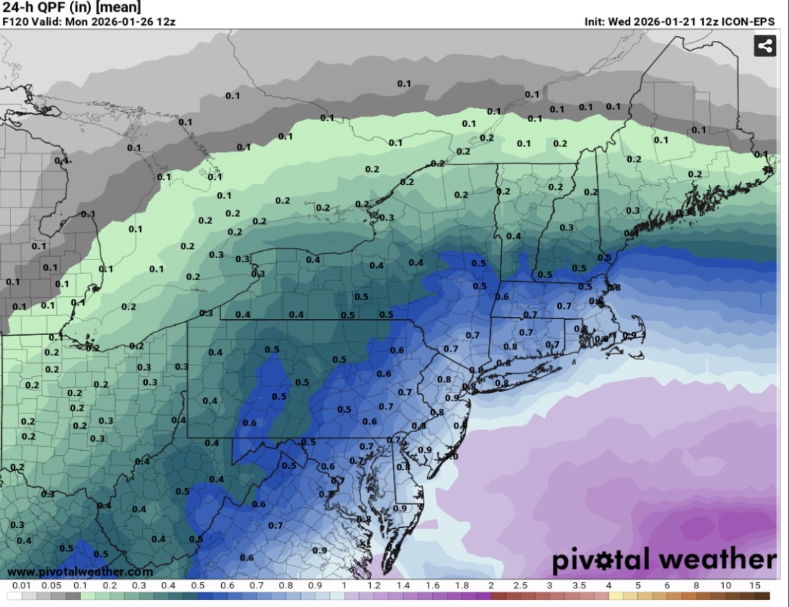
got it. It’s the icon anyway. the icon eps qpf mean instead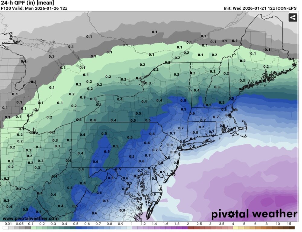
-
January 2026 regional war/obs/disco thread
JKEisMan replied to Baroclinic Zone's topic in New England

-
January 2026 regional war/obs/disco thread
JKEisMan replied to Baroclinic Zone's topic in New England
And that’s 10:1 ratios. Easily 1+ ft across SNE with ratios. EPS putting up close to 1” qpf up to 144 hrs. -
January 2026 regional war/obs/disco thread
JKEisMan replied to Baroclinic Zone's topic in New England
Yeah, was just gonna post. Slings a bunch of additional snow back into NE. Hope that look continues.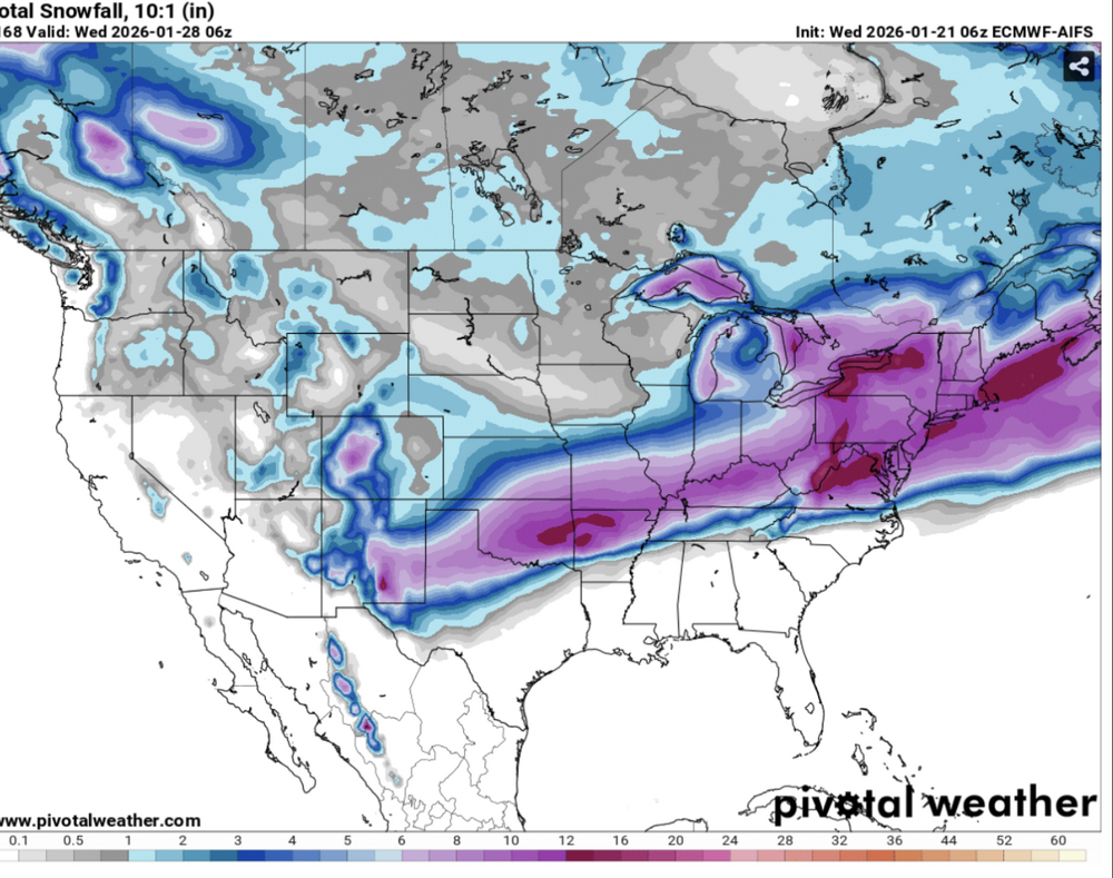
-
January 2026 regional war/obs/disco thread
JKEisMan replied to Baroclinic Zone's topic in New England
Yeah Canadian faster and way north -
January 2026 regional war/obs/disco thread
JKEisMan replied to Baroclinic Zone's topic in New England
It’s gonna go boom -
January 2026 regional war/obs/disco thread
JKEisMan replied to Baroclinic Zone's topic in New England
Winter of yore -
January 2026 regional war/obs/disco thread
JKEisMan replied to Baroclinic Zone's topic in New England
Yeah, crossing fingers but I think SNE is in a good spot for this one. We have a ways to go though, gonna be a fun one to track regardless. -
January 2026 regional war/obs/disco thread
JKEisMan replied to Baroclinic Zone's topic in New England
Must be some secondaries on the EPS because duration/qpf goes longer. Nice to see that as well -
January 2026 regional war/obs/disco thread
JKEisMan replied to Baroclinic Zone's topic in New England
Good bump north on EPS total QPF when compared to 0z. -
January 2026 regional war/obs/disco thread
JKEisMan replied to Baroclinic Zone's topic in New England
People, snow is on the way. Chill