

ILSNOW
-
Posts
1,642 -
Joined
-
Last visited
Content Type
Profiles
Blogs
Forums
American Weather
Media Demo
Store
Gallery
Everything posted by ILSNOW
-
-
Active meso's at the moment
-
to add on Any supercells than can remain on the warm/south side of the front will be capable of producing tornadoes, a few of which could be strong (EF-2/3). Some consideration was given to including greater tornado probabilities and a Moderate Risk (level 4 of 5) focused across southern WI/far northern IL. But, convection may have a tendency to grow upscale fairly quickly this evening, so confidence was not high enough for a categorical upgrade at this time. Regardless, very large to giant hail (potentially up to 3-4 inches in diameter) will be a threat with sustained supercells, and a swath of severe/damaging winds appears likely with a convective cluster spreading eastward across southern Lower MI this evening into tonight.
-
latest from SPC Morning water vapor imagery shows a strong shortwave trough over northeast KS, with an associated mid-level jet and dry-slot rotating around the base of the trough into western MO. A deep surface low currently south of OMA will track northeastward across IA this afternoon, with a tight gradient of low-level moisture and instability along the track of the low. Very strong low-level shear and sufficient CAPE in the warm sector will pose a risk of fast-moving supercells capable of damaging winds, tornadoes (possibly strong), and hail. The area of greatest concern is over eastern IA into northern IL and far southern WI. Perhaps the biggest forecast uncertainty is the widespread cloud cover and limited diurnal destabilization, but the approaching dry slot may compensate by mid-afternoon and allow a period of afternoon heating.
-
chicago update We just recently updated the forecast to upgrade our Winter Storm Warning to a Blizzard Warning. We also included Dekalb and McHenry counties in this warning. We also expanded the Winter Weather advisory anther row of counties southeastward along the I-55 corridor. The storm system is tracking farther south then originally thought. Overall, this adds concern that snowfall amounts may end up a bit higher than previous forecasts, particularly across the warned area where several hours of wind gusts of 45 to 50 mph will combine with the snow overnight into Monday morning to produce blizzard conditions. With this in mind, and the fact that there are numerous upstream obs across IA and parts of MO that are reporting 1/4 or less VSBYs, felt the path of least regret was to pull the trigger on the upgrade.
-
went from 62 to 37 in 1.5 hours
-
seems more believable
-
12z GEFS seems overdone
-
chicago updated We have opted to upgrade the Winter Storm Watch across our northwest to a Winter Storm Warning from 7 pm this evening through 1 pm Monday. We strongly considered a Blizzard Warning, but have opted to hold off on that at this time, though cannot rule out the need to upgrade as the event unfolds this evening. Either way the combination of falling and accumulating snow with widespread blowing snow and gusty northwest winds (up to 50 mph) will make for near blizzard conditions at times tonight into Monday morning across northwestern IL. Total snowfall amounts in the warned area are expected to be in the 3 to 6 inch range. In addition to the warning, we have also opted to issue a Winter Weather Advisory from 10 pm tonight through 1 pm Monday for areas east-southeast of the Winter Storm Warning. This basically includes areas nearly as far southeast as the I-55 corridor. Snowfall amounts in this region are expected to be lighter, generally in the 1 to 3 inch range. However, the combination of the snow and blowing snow will also make for hazardous conditions outside of the Warning area Monday morning.
-
Agree how many times have we been forecasted to get 1-3 from a deformation band and end up with 30 minutes of flurries
-
I will settle for this Image
-
Better Image
-
Image
-
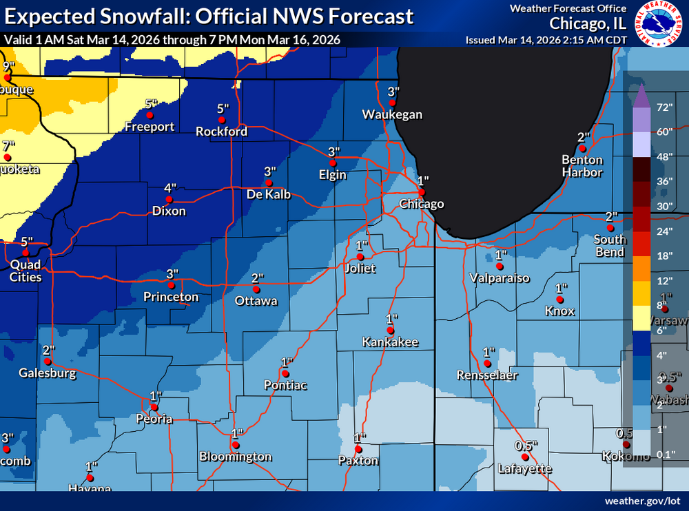
Chicago There continues to be some differences amongst guidance in terms as to how much additional moisture will fall as snow in the deformation band of the cyclone into Monday morning. However, given the expected track of the system, forecast thinking continues to favor the heaviest snow axis from northwestern IL into WI, with much lighter amounts with east-southeastward extent across our area. This results in general forecast snow amounts in the 2 to 5 inch range in my far northwest (near the Rockford area), dropping to only an inch or two across the Chicago area and points southeast. conditions should become more hazardous with time Sunday night, with the potential for periods of near blizzard conditions at times, particularly across the more open areas of northern/northwestern IL. These poor conditions are expected to continue into Monday morning before the snow gradually tapers off from south to north through the day on Monday.
-
-
Milwaukee update Iowa-Dane-Jefferson-Waukesha-Milwaukee-Lafayette-Green-Rock- Walworth-Racine-Kenosha- Including the cities of Delavan, Mineral Point, Monroe, Kenosha, Whitewater, Brodhead, Shullsburg, Lake Geneva, Fort Atkinson, Muskego, Argyle, Blanchardville, Madison, East Troy, Belmont, Watertown, Janesville, Milwaukee, Darlington, Jefferson, Benton, Brookfield, Waukesha, New Berlin, Racine, Dodgeville, Beloit, Elkhorn, Barneveld, and Menomonee Falls 140 PM CDT Sat Mar 14 2026 ...WINTER STORM WATCH REMAINS IN EFFECT FROM SUNDAY AFTERNOON THROUGH MONDAY EVENING... * WHAT...Heavy mixed precipitation possible. Total snow accumulations between 4 and 7 inches and ice accumulations around a light glaze possible. Winds could gust as high as 50 mph.
-
National Weather Service Des Moines IA 1134 AM CDT Sat Mar 14 2026 ...BLIZZARD CONDITIONS SUNDAY INTO MONDAY MORNING... WHAT...Blizzard conditions expected. Total snow accumulations between 2 and 4 inches. Winds gusting as high as 55 to 65 mph.
-
looking forward to dusting #13
-
-
18z ICON backed down to earth as expected.


