TheBudMan
-
Posts
418 -
Joined
-
Last visited
Content Type
Profiles
Blogs
Forums
American Weather
Media Demo
Store
Gallery
Everything posted by TheBudMan
-
September Discussion Thread: Bring the frost; kill the bugs.
TheBudMan replied to moneypitmike's topic in New England
A Ginxy and Rev special. The moon coming up at Good Harbor Beach and a great Foam Brewing beverage #beer !!! -
September Discussion Thread: Bring the frost; kill the bugs.
TheBudMan replied to moneypitmike's topic in New England
Under an EHC and we can't even get a post from Wiz ? what gives ??? -
I think we need to have Jay and Wiz snuggled up at the Cape house tonight. Wiz scanning the dark skies over the ocean looking for F4s about to come onshore while Miley Cyrus softly plays in the background and spiders crawl across the floor towards him.
-
You just know @Damage In Tolland is hoping the eye passes about 25 miles to his west RFQ FTW !!!
-
*if* Henri approaches can I request a series of posts from Tip on how he's going to board up his new windows ? Also do we uninstall when a Hurricane comes ? so many questions for us
-
This is like a winter storm. Can't wait for all the 12Z models to move 1000 miles east and weenies to be crushed. Hopefully the busload of MILFs on the way to see Pickles doesn't turn around
-
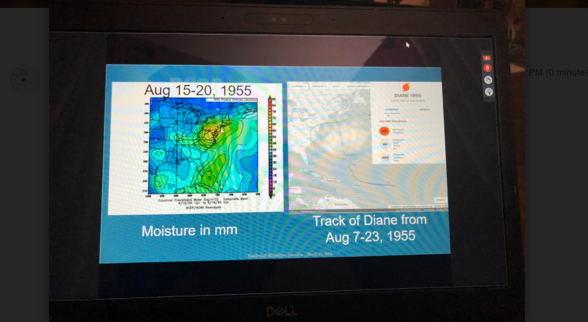
Where is Wiz ? We keep getting 384 hr maps of EMLs for days from him and now here comes Thursday and he's on the bench with the scorebook again Depending on the model of choice values range from generally 1000-2000 J/kg on the conservative side of guidance of MLCAPE with the NAM being a bit of an outlier with MLCAPE ranging from 1000-4000 J/kg with the highest values in western portions of the CWA. On top of this will have an EML moving in aloft on Thursday with mid level lapse rates between 6- 7 degrees Celsius per km and 7.5-8.5 degree Celsius low level lapse rates. One thing that may help us in the severe risk is it doesn`t look like things move in until late in the day.
-
@Ginx snewx approved day on Goose Rocks Beach in Kennebunkport !!
-
We can adjust up as needed. The TreeHouse was flowing for @Damage In Tolland today. Angry refills needed quickly watching his Spankees choke. Nothing wrong with that !!
-
I am ready for a derecho into southern Maine at 3 AM. Please make it happen @OceanStWx [emoji41]
-
All @Damage In Tolland wants is a picture of the lawn.....is that too much to ask for ?
-
any hope for next week Tip or do I make like Ray and get into the tub and turn the toaster on ?
-
Report to Jay first, priorities Wiz !!! he's a bigger than you !
-
Outflow is great, temp dropped in Reading could feel it come through !
-
Wiz I'd be careful, I hear Springfield is overrun with massive spiders. might be easier to sit in the hot tub and wait for them to come to you
-
Rev getting piggy piled. Hate to see it. No Stein lyrics this weekend needed.
-
Guest appearance in late May by Ray as he preps his 21-22 winter forecast ! Big snow returns
-
Tip can post all he wants but any NE Severe ain't for real until King @weatherwiz starts honking !!!
-
I hope George forecasts during hurricane season that'll be awesome if there's a beast down by the Bahamas
-
Sounds like Pickles got shot down one night at Allisons
-
Anxiously awaiting George's updated forecast. 50-75" regionwide lolli's to 100" ??
-
Scooter/Ginxy vs. Kevin hmmmm who will win RevKev a week from now
-
All these April Fools posts today are going to reel poor Tip in ...... every one em
-
Steve using the GEFM (George Extreme Forecast Model) ??[emoji3]
-
Anyone else watching this from NWS tonight ? What a I am Great job NWS BOX mets !