Joe Clark
-
Posts
41 -
Joined
-
Last visited


.thumb.jpg.a628c2147efdff1c820341d5143d9237.jpg)

-

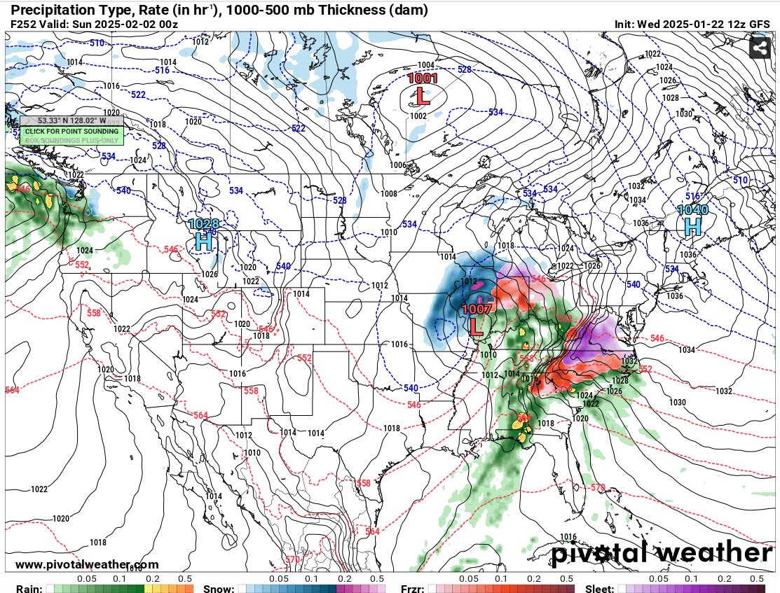
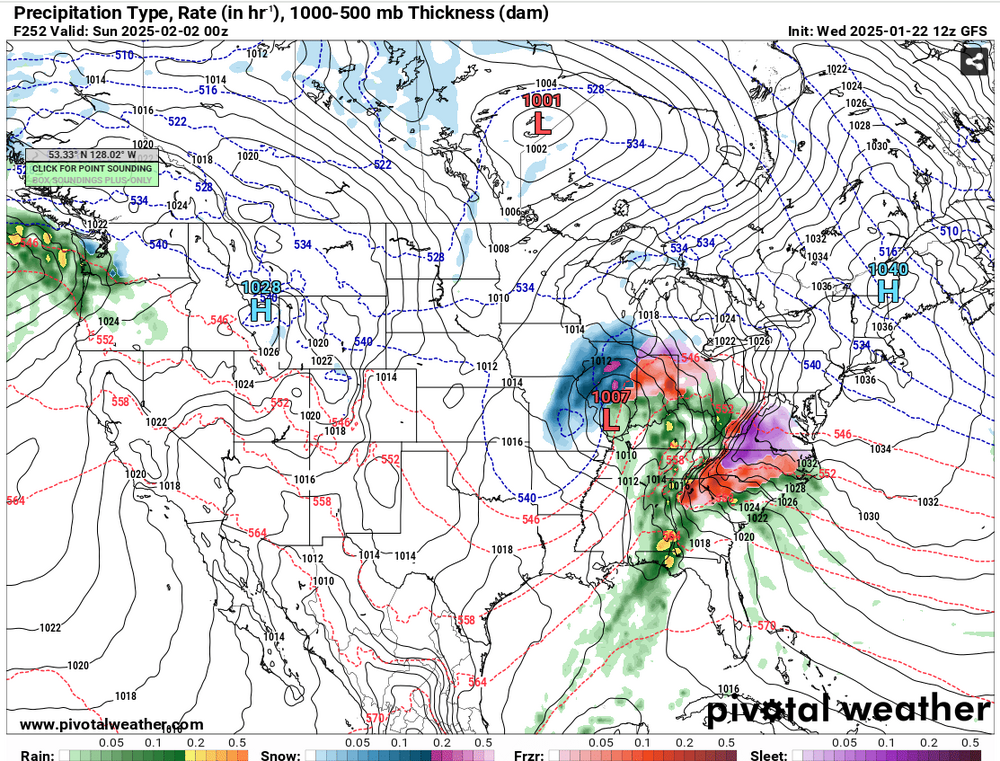
The “I bring the mojo” Jan 30-Feb 1 potential winter storm
Joe Clark replied to lilj4425's topic in Southeastern States
This is the one… -
18z GFS has it too, but further south...
-
February 19-20 Major Winter Storm Threat
Joe Clark replied to NorthHillsWx's topic in Southeastern States
Thats what I was thinking too. Looks like more QPF than the 6z run. -
Make that three runs in a row now.
-
Agreed. One of the other local Mets out of W-S said this morning to expect a dusting in the triad.
-
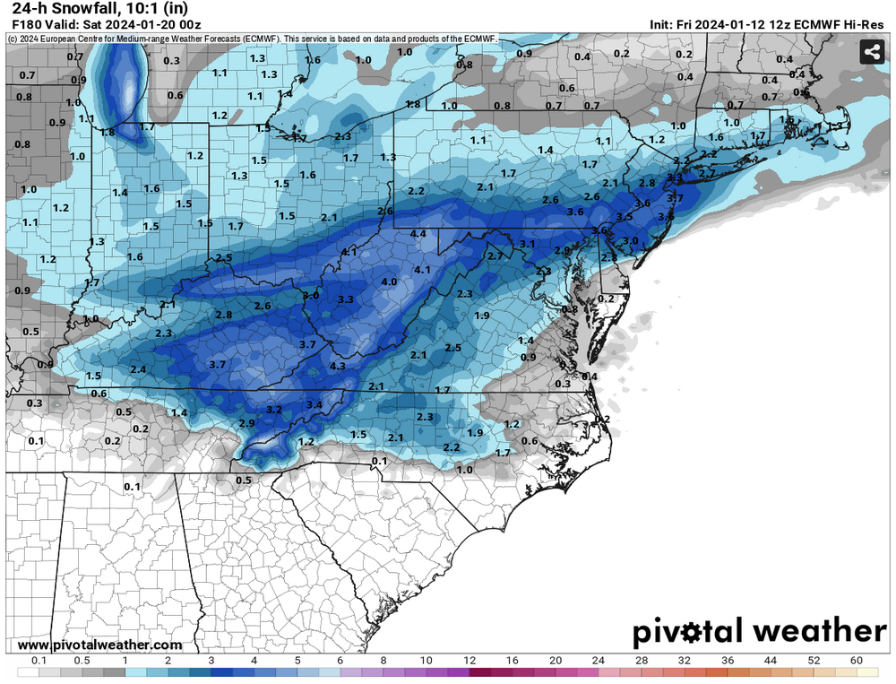
Might be right. From our storm last week:

-
Didnt the GRAF lead the way with the drier weaker trend we've seen in the last 18 hours?
-
#facts. Its exhausting.....
-
Yes. Seen it a thousand times before.
-
-
Until the Euro gets on board with the Tuesday system I'm skeptical. I've seen plenty of times where the Euro lost a storm and was on its own and then watched as everything else caved...
-
Been trending colder the last couple of runs.... overdone?
-
Agreed, don't start a thread yet.... usually when its too early its the kiss of death.
-
NWS RAH is showing some interest in this time period as well. LONG TERM /SATURDAY THROUGH WEDNESDAY/... As of 320 AM Thursday... Temperatures will depend on the exact location of a frontal zone meandering over the SE US, with additional CAD conditions very possible. Finally, rain should be the primary precip type through at least Thursday. Thereafter, the uncertain arrival of Canadian air into the area will likely hold off until Friday/Saturday, which would yield increasing chances for wintry precip as additional moisture overspreads the area from the SW. Stay tuned.
-
From the Afternoon RAH disco: Long Term: The forecast really gets interesting during the late week period(late Wednesday night through Friday) with high forecast uncertainty wrt to just how much amplification of the cold upper trough will occur over the central and eastern US via additional energy/northern stream energy diving south out of SW Canada. If some of the stronger/deeper H5 height patterns verify, a developing coastal storm tracking along the SE Coast, coupled with the antecedent cP airmass in place, could support the potential for some frozen precip across the climatologically favored areas of the NW Piedmont. Evaluation of the latest 00z/15 Grand Ensemble guidance(100 ensemble members consisting of the CMC, EC, and GEFS members) indicates that ~20 percent of the combined members show measurable snow over the northern Piedmont, with a little over half of those snowy members indicating light snow amounts of 1 inch or less. With that said, these probabilities and related p-type forecast and amounts will without a doubt fluctuate over the next several days.