

Silas Lang
-
Posts
696 -
Joined
-
Last visited
Content Type
Profiles
Blogs
Forums
American Weather
Media Demo
Store
Gallery
Posts posted by Silas Lang
-
-
Had some lightning here this evening as well sometime around 5pm. Took me by surprise honestly as I had to think for a second as I was looking out the window when it happened. lol Pretty unexpected!
-
 3
3
-
-
39 minutes ago, weathertree4u2 said:
And that is a surprise? OMG
Not really. Just an observation.
-
1
-
-
2 hours ago, Silas Lang said:
Huge improvement. Not a hit, but I would take it this far out anyway. Way better than the cold rain look we had been seeing. The ingredients are at least there on the 12z run.
Annnddd the 18z looking totally different. lol
-
3 hours ago, Holston_River_Rambler said:
12z GFS at hour 190ish looks beautiful. I’ll take that look even if it ends suppressed later in this run.
Huge improvement. Not a hit, but I would take it this far out anyway. Way better than the cold rain look we had been seeing. The ingredients are at least there on the 12z run.
-
4
-
-
3 hours ago, John1122 said:
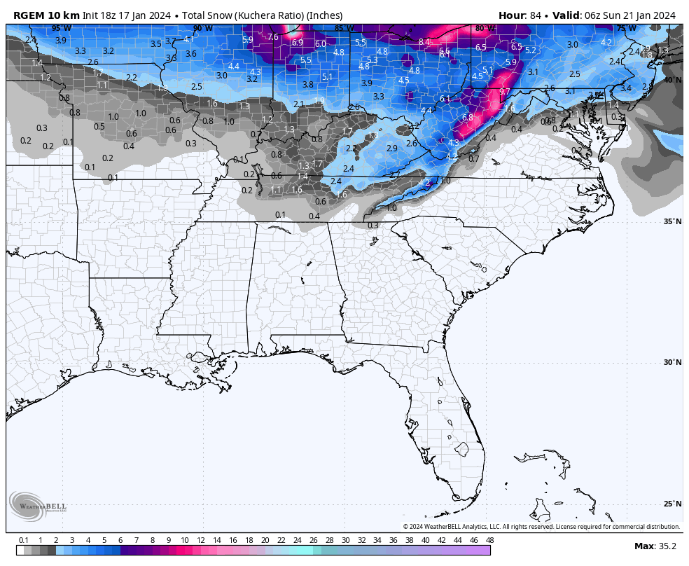
21 inches imby. Everyone does okay 40 and north. That's actually 1 of 2 for some areas in the western forum. They get 4-8 inches a few days before it on the back side of a low. Areas just west of Clarksville also get 20 inch totals.
24 hour snowfall
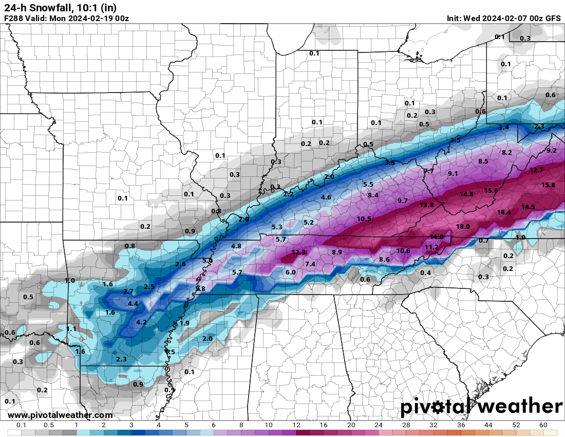
I don't know what maps Pivotal weather shows, but the kuchera ratio is a bit lower on totals. The southern edge of precip has some sleet and freezing rain mixed in in eastern areas. Seems there is a warm layer around 700mb on the 0z run. Pretty weird, as it is a pretty stout cold elsewhere.
Interestingly enough, the 06z GFS has a better low placement, but weaker cold air. That said, still way too far out to worry about the finer details.
We now have a couple of runs showing a signal. The Euro and Canadian should be in range tonight. Curious to see if they support this setup.
-
1
-
-
Pretty annoyed to see the NCAA is looking into UT for NIL. That organization is an absolute joke. Hope the university (along with others) sues them to oblivion.
-
2
-
-
1 hour ago, Holston_River_Rambler said:
The end of that GFS run looked ideal.
I was about to say, finally some real cold looked to filter down at the end of that run. When it's raining in Minnesota, it's hard to get snow here. lol
I know it's the GFS at 384, but it lines up with what some of y'all of been saying about mid February onward and opportunities.
-
5
-
-
25 minutes ago, Carvers Gap said:
Textbook Miller B, Mid Atlantic track. Energy goes through middle TN and then hands off to the Piedmont. Not good for us, but certainly that is a big storm signal for them and maybe NC.
Yeah, now that you mention it, I seem to remember this happening a few years ago. I was thinking "there is no way that low travels due north"...and it very well did! lol
Wasn't there another one last year (maybe the year before) where the low travelled straight into the mountains?
Regardless, I don't like energy transfers. Hope it stays a simple Gulf low for all of us.
-
3
-
-
And the CMC is...something. Takes the Gulf low due north to Nashville then transfers to Asheville then finally goes to the coast with another low popping off the coast of GA at the end. Sort of crazy look all over the place.
EDIT: to be clear, this about the storm potential on the 5th.
-
4
-
-
12z GFS interesting. Flirting with something big on the 5th.

-
3
-
 1
1
-
-
The Cumberland mountains look like they are getting hammered. Hard to see through the clouds, but looks like areas over 2500 feet or so are white.
-
4
-
-
1 hour ago, Carvers Gap said:
I had the unfortunate honor of taking one-too-many computer programming classes while in college. I had a math class where we had to write calculus programming in basic - gag. I could do fundamental programming, but calculus rarely agreed with me. Fortunately, I had a buddy who was great at calculus, and we handled the programming together. Computer wx models are nothing just programming code. Take some time to think about that. I will say this, some of what we see on modeling looks like infinite loops - meaning the program gets locked onto a trend and cannot move to anything new. We see that in the form of feedback on the NAM at range. We have seen that with recent MJO plots. When it is warm, modeling tends to stay warm. The opposite is also true. Sometimes the change itself is feedback. It seems that problem has been worse this winter. I also think that three years of Nina data has really skewed modeling towards Nina responses. In reality, this is a textbook Nino winter so far. If I hadn't looked at a model and had been blindfolded from all internet data, this feels like a Nino winter - cold, damp, rainy, cloudy, some cold, big snows, grass gets green early(no lie...weird characteristic of Nino winters).
Man, that is weird about the grass. Was noticing today that mine looks way greener than before the snow. Does all that moisture from the snow and protection from bitter cold with snowpack, help the grass or something?
And about the models struggling with all the niña data, the snowstorm we just experienced was modeled as a cutter, similar to the past couple of years until they finally settled on what we got, more or less.
-
2
-
-
9 minutes ago, Holston_River_Rambler said:
I bet some folks in TRI SWVA and Eastern KY would have liked the overnight Euro too:
Yeah, the GFS has the same storm, but sends it out to sea. The Euro is a little confusing with low pressure popping up everywhere. Some potential in the time period for sure!
-
3
-
-
23 minutes ago, bearman said:
Well now it is coming down hard enough to start adding to our totals. It is getting close to a half and inch here in West Knoxville.
Same here. Pretty crazy. Got a fresh coat. I can't see the yellow spots from the dog! lol
-
7
-
-
Man it is really coming down now. A stout NWF for the valley.
-
4
-
-
Some flurries/ light snow. Already got a dusting on top of the ice.
32 now. Looking at thermometer it hovered between 30 to 33 last night. It's a mess.
-
2
-
-
Disappointed to say that I have had a couple of brief showers of freezing rain. It wasn't a downpour, but the drops were heavy and it was a moderate rainfall. I expected drizzle or maybe light rain briefly, but this is more than I anticipated. I have had drizzle in between the moderate showers. I heard what sounded like a brief period of sleet. It's nasty out.
I have no idea how to measure ice, but it is a much thicker than a light glaze. Dog slipped going out. It has consistently been 31, but I am sure the ground is much colder.
A cool little element from this weather is due to some melting from sun in cold temps and the freezing rain, I have some rather sick looking icicles hanging off the house. I swear one of them is closing in on 3 feet. Gonna have to measure tomorrow.
Anyway, stay safe y'all.
-
1
-
 1
1
-
-
Is Knox getting dry slotted? I am 100% okay with this. Have a had a little drizzle and melt from sun today so I already have enough ice!
-
1
-
-
11 minutes ago, John1122 said:
If this happens as a drizzle/ight rain scenario it's the worst way to get freezing rain for travel. If it rains hard it builds up on raised surfaces but the way roads are designed to shed water, the water starts running and it's harder to freeze. But light rain that slowly builds, that's just the worst.
It really is worse for it to be light. When I lived in Asheville, new years eve 2017, it sprinkled for maybe 5 or 10 minutes? But the temps has been cold and it instantly made the roads treacherous. I had to walk home five miles because I almost died driving and just decided to park the truck, wasn't worth it. Numerous wrecks, stalled traffic, terrible all around and all over like .01 inch of freezing rain.
Worst part was you couldn't even see any ice. But my truck certainly felt it. Needless to say, one of the few new years I spent alone. lol
-
4
-
-
8 hours ago, John1122 said:
The GFS from 00z 1-16-24 had me at -8 and I ended up at -8. It had Newcomb, west of me at -6 and they ended up at -7. It had Oneida at -7 and they ended up at -9. It had Tazewell at -14 and they ended up at -12. Our posters in the area also seemed to have recorded -8 to -10. Unfortunately TYS is not actually in Knoxville or Knox County, and it's a notorious heat island, I believe they didn't get quite as much snow as areas very close by to the N and NW.
A bit off topic, but it drives me nuts how TYS is "Knoxville." It was the same when I lived in Johnson City and "TRI" was the official record. Honestly that one is worse because Bristol, Kingsport, and JC all can have vastly different conditions. It was even similar when I lived in Asheville and "AVL" was very similar to "TYS" where the airport is well south of the city proper and would get blanked at times the city would get a couple of inches.
I mean, how hard is it to have an official record for towns and cities? Drives me nuts. Should be easier than ever with tech too.
-
1
-
-
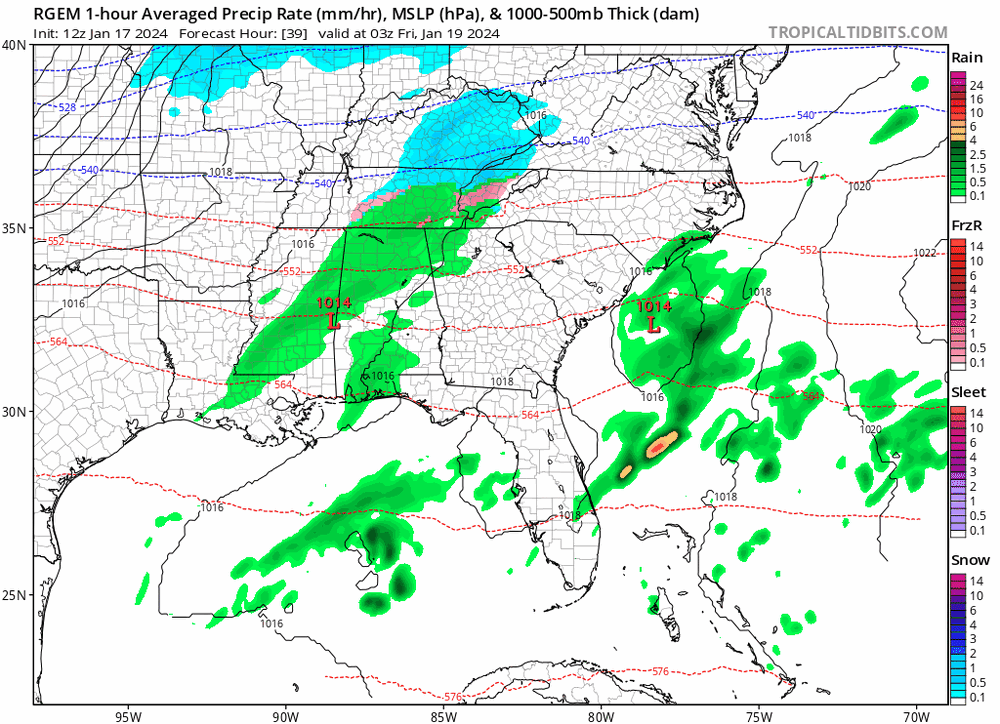
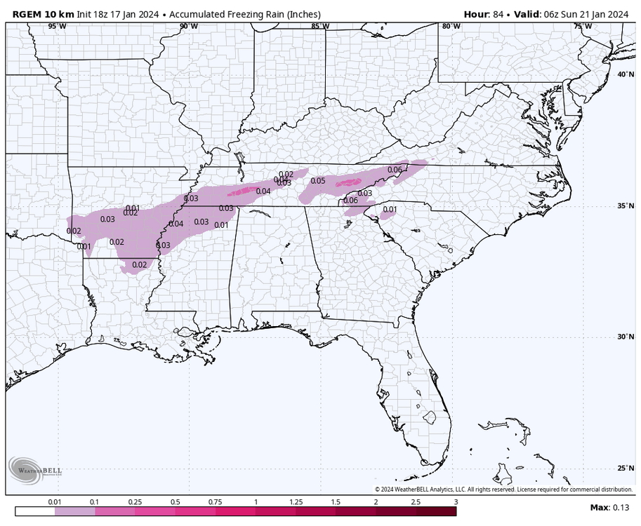
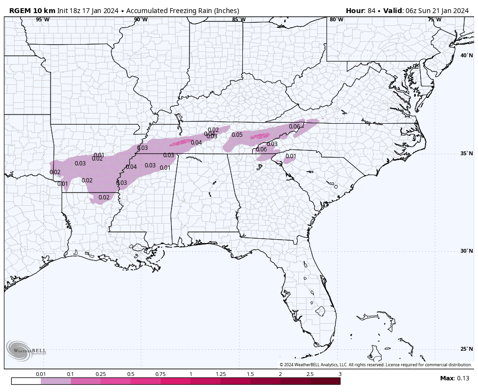
1 minute ago, Silas Lang said:
My fears look like they are coming to fruition. Ice, ice baby.
Oddly enough, the RGEM is actually trending the snow line into the central valley with limited ice the past couple of runs. Curious to see if the 12z holds. I want that solution to be correct! lol
RGEM trend
-
5
-
-
1 hour ago, Carvers Gap said:
HRRR looks icy and MRX agrees(light icing to clarify):
Isentropic lift ahead of a surface low to our west will result in
increasing clouds and light precipitation this evening into the
overnight hours. Confidence is increasing in freezing rain and
light ice accumulation across the region, especially for the
valley around 0z and later this evening. Model guidance continues
to show a warm nose in the 2 to 4C range around 800-850mb which
should melt any snow to freezing rain. Amounts appear light, but
most areas should expect around 0.1 inch or less with localized
spots up to 0.2 inch of ice accretion. We have trended towards the
HRRR and colder guidance for temperatures with this system which
seem to better account for the dense, cold air across the valley.
This is a case where pattern recognition is important to
consider. Models routinely overestimate the surface warm air in
these situations and move the cold air across the valley out too
quickly. With this dense, arctic airmass and snowpack, shallow
cold air will be very slow to exit the valley, especially
sheltered valleys across the area. This light freezing rain will
likely create hazardous travel conditions overnight and into
Friday morning. We have expanded the Winter Weather Advisory based
on the slightly cooler forecast and additional areal coverage of
light ice accretion.

Colder air will advect into the region behind the cold front on
Friday with some light snow possible across the area. Most
locations will only see flurries or a dusting, but a few inches of
snow will be possible across the higher elevations of the
mountains where northwest flow and low-level moisture persists.
This light snow continues through the day on Friday and tapers
off to flurries and rime ice on Friday night.
My fears look like they are coming to fruition. Ice, ice baby.
Oddly enough, the RGEM is actually trending the snow line into the central valley with limited ice the past couple of runs. Curious to see if the 12z holds. I want that solution to be correct! lol
-
2
-
1
-
-
17 minutes ago, PowellVolz said:
I don’t see areas with 6-8” of snow on the ground warming 30 degrees or more tomorrow. This system isn’t that strong and it’s not a wrapped up cutter with strong advection.
.My thing is, I think we can easily stay below freezing at the surface, but we still get rain. It will just be freezing rain. A little warm air up high is not impacted by the ground. Maybe best case, there is lower level cold that keeps it sleet or something?
I don't know. Just worried about the impacts of this rain on 9 inches of snow. I would love snow instead!
-
4
-
1
-
-
RGEM is persistent. Also been the best with temps, for me at least. It shows a chilly upper 20s in the early morning hours with rain for the central valley. Temp profiles seem to highlight snowpack fairly well.

-
3
-

Winter 23-24' Wx Observations Thread
in Tennessee Valley
Posted
Just wanted to say, I love these posts about little micro features.