

Silas Lang
-
Posts
696 -
Joined
-
Last visited
Content Type
Profiles
Blogs
Forums
American Weather
Media Demo
Store
Gallery
Posts posted by Silas Lang
-
-
2 minutes ago, Chattownsnow said:
Precip appears a little south of expectations maybe? Or am I just seeing what I want to see? Lol
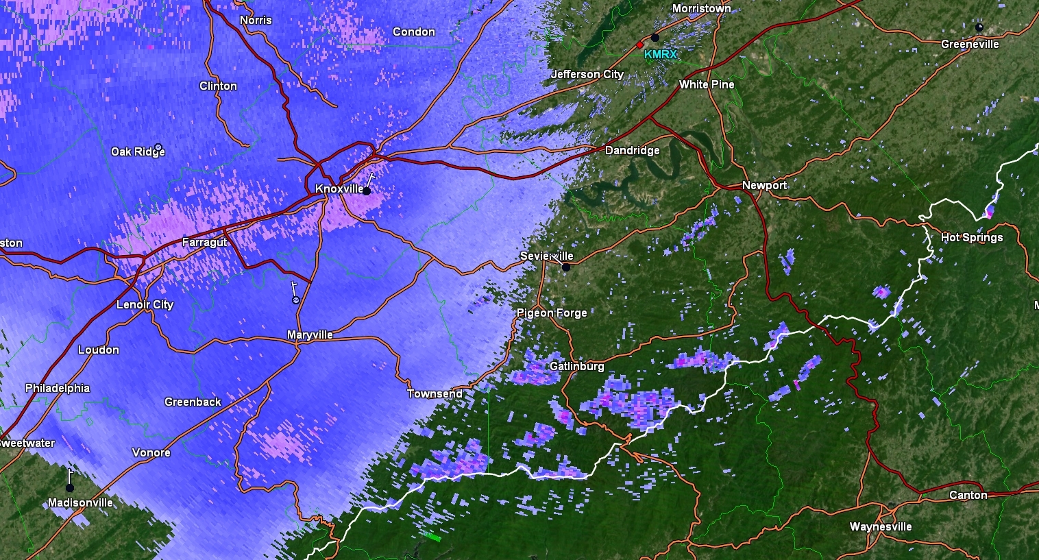
.It looks beefy to me. Which means it looks to encompass more north and south than some of the models indicated. Also considering the fact that I have had snow with zero returns over me is impressive. I was expecting a lot more virga.
-
 1
1
-
-
Just now, MattPetrulli said:
TYS reporting moderate snow with this band, first real band about to come through.
Yeah, crazy that it is just now starting. Seems like it is leaning towards an over performer,but I guess we will see!
Any reports out west?
-
1
-
 1
1
-
-
Just now, jaxjagman said:
Its very rare to snow across all of us
Yeah, this storm could prove to be truly historic. A long duration, state wide mauler of a snow storm. Factor in the artic air and the fact that things will be shut down a few days...this one will be remembered.
-
4
-
1
-
-
It's legitimately insane to me that tomorrow afternoon, nearly the whole state is still covered in snow on radar. It has been a long time since we have had a long duration event.

-
7
-
-
17 minutes ago, TellicoWx said:
3k

-
3
-
-
37 minutes ago, Greyhound said:
Coming down pretty good in Fountain City
.Yes. I already have a dusting. And then you look at the radar and nothing of note has even hit yet. lol
-
4
-
 1
1
-
1
-
-
3 minutes ago, Stovepipe said:
KTNKNOXV744, there's a link in my sig. Just hit the freezing mark!
Same here in Fountain City. Just hit 32.
-
4
-
-
1 minute ago, Mrwolf1972 said:
weather channel has named our storm Heather lol
Well then. I look forward to meeting Heather.
-
1
-
-
15 minutes ago, Silas Lang said:
So...if this bias is showing in the short range models, does that mean some locations could possibly see something like 50% more snow than modeled? Goodness.
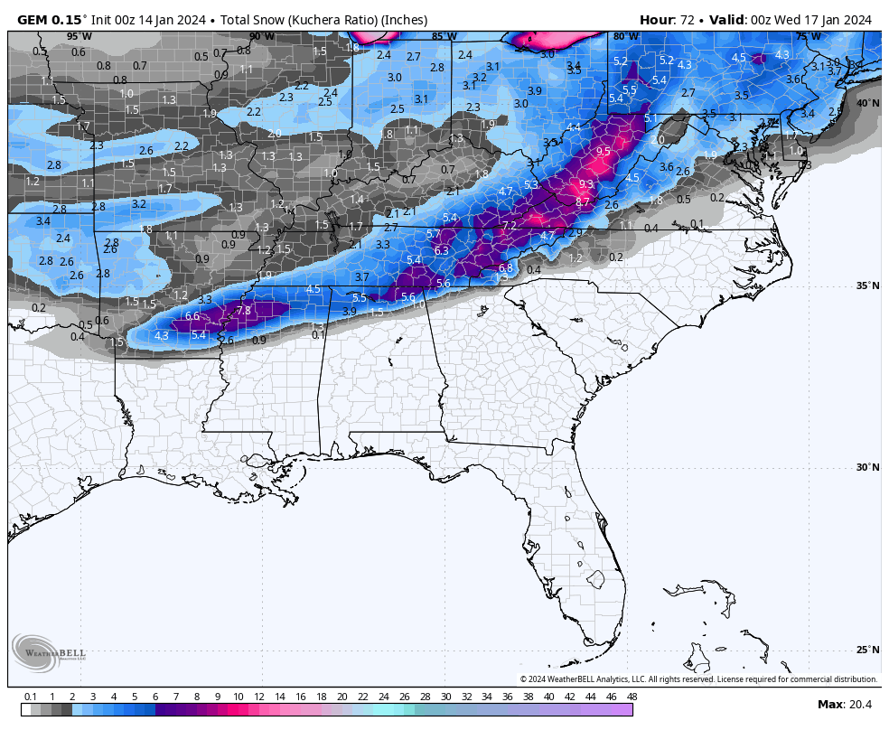
Reading the latest MRX discussion, they seem to think most likely ratio is 12 to 1 to 15 to 1 ratios area wide. They only mention the southern border counties as the only exception.
Seems they are not worried about warm air and also mention wherever the area of .50 to .80 precipitation sets up could get well beyond 6 inches. They seem very bullish overall. Don't see that often!
-
2
-
-
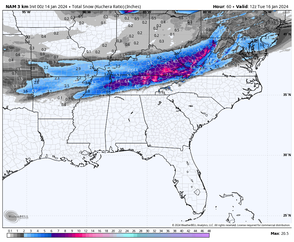
10 minutes ago, ShawnEastTN said:14 minutes ago, John1122 said:It looks like it in counties that touch 40 in East Tn and points south. The globals are the best case scenario, giving 12/13:1 over those areas but it lowers into the 10:1 range as the day wears on. The Canadian/GFS look similar. The hi-res models seem to see more warmth but it may be a bias with them. At one point on the NAM your area has 11:1 ratios and McGhee-Tys is closer to 7:1.
Yeah I think a lot of bias is playing into the ratio forecasting much like mixing is. I think the depth and strength of the cold isn't really being modeled well by most and that ratios will be higher likely than most models are showing.
So...if this bias is showing in the short range models, does that mean some locations could possibly see something like 50% more snow than modeled? Goodness.
-
3
-
-
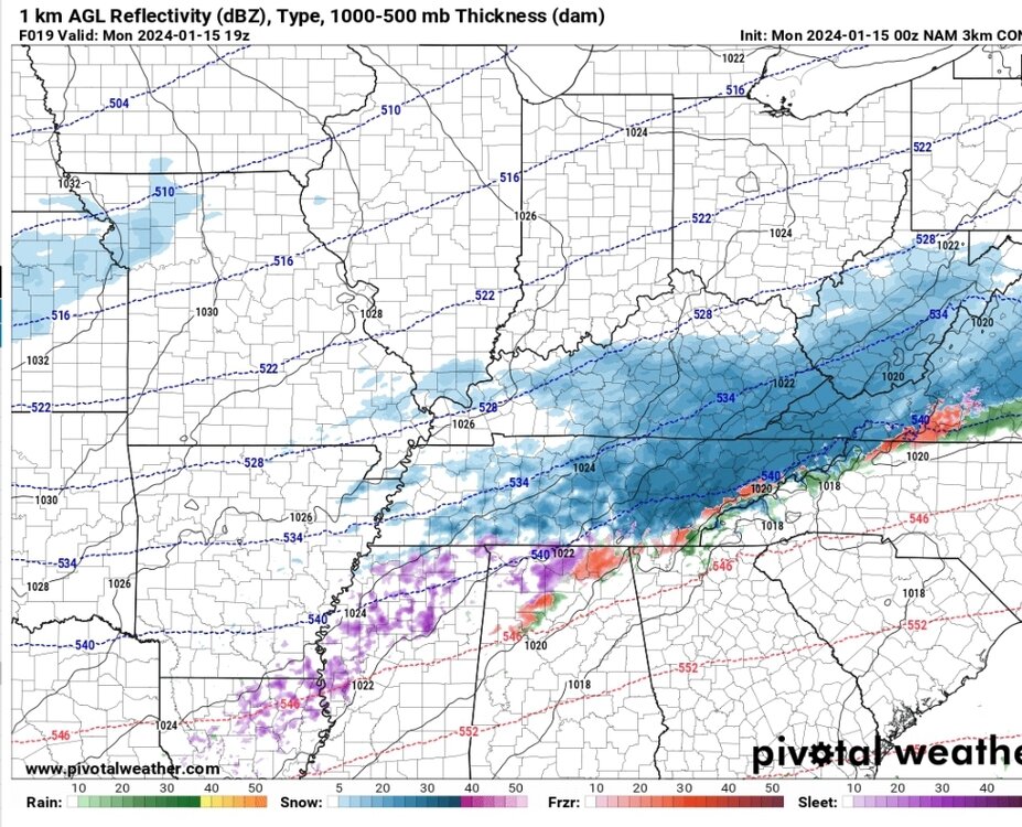
Here is the Canadian
-
2
-
4
-
-
And here is the 0z GFS

-
2
-
-
1 minute ago, Bigbald said:
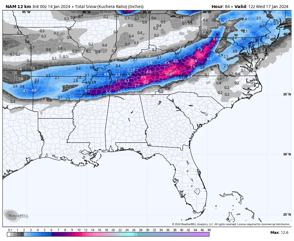
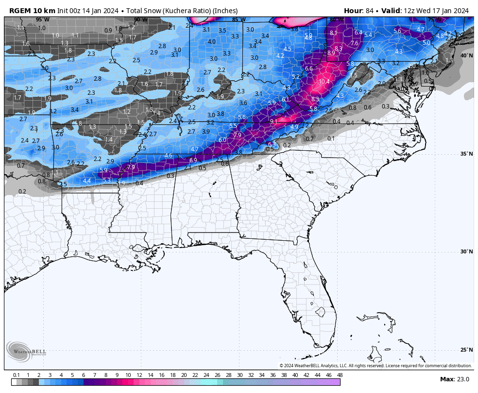
For SWVA folks, Look at the agreement on the NAM and RGEM for the communities of Duffield/Jasper/Big Stone Gap.
Here is the NAM

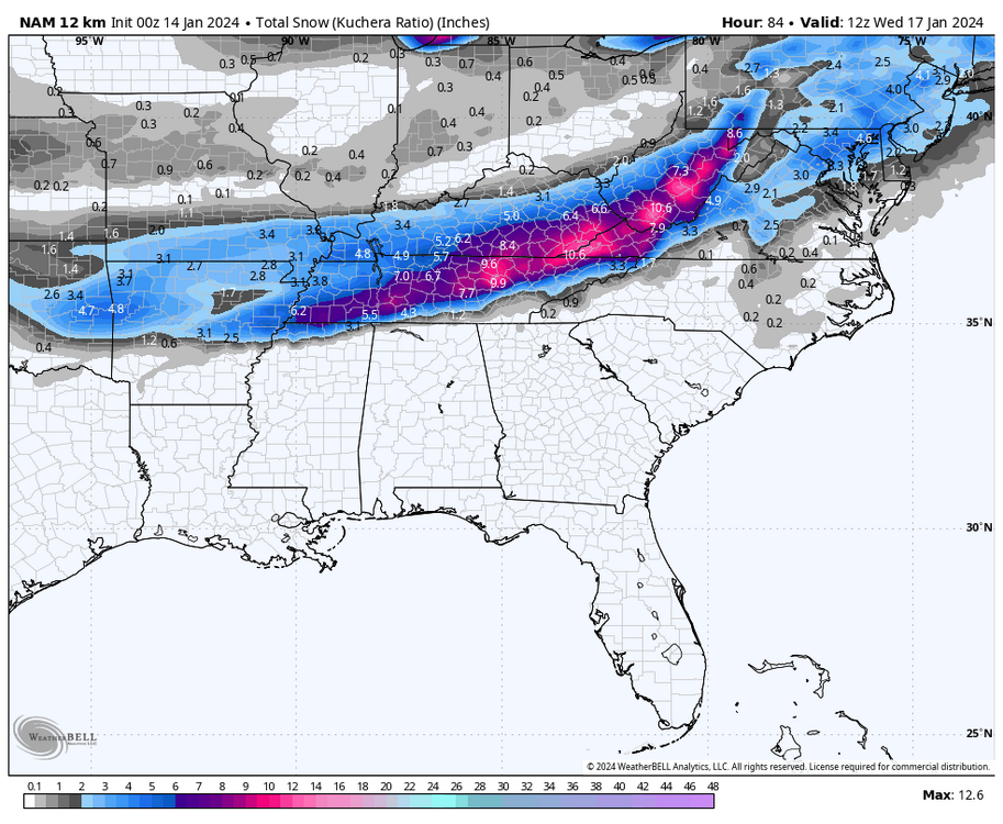
-
Latest ICON
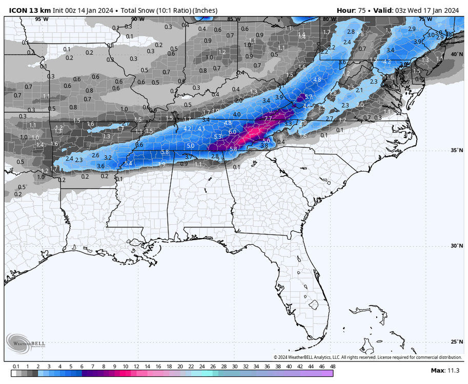
-
2
-
-
0z RGEM pretty much the same as the 18z, but gives a little bit more to areas favored last run.
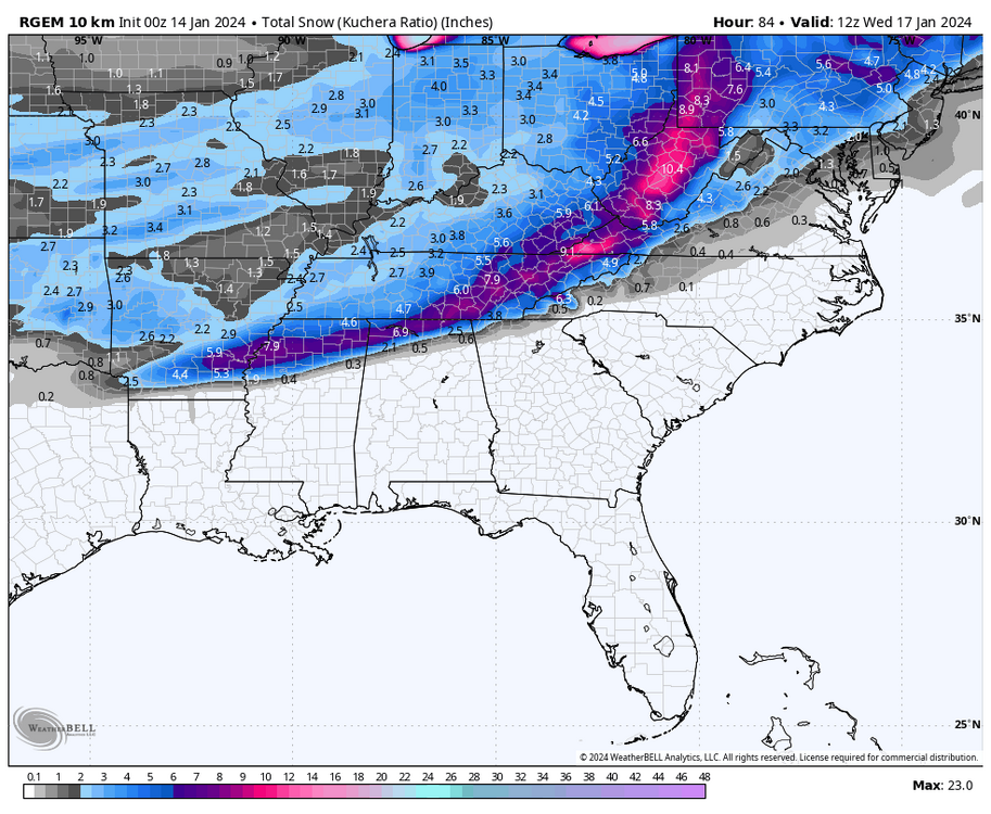
-
2
-
 1
1
-
-
Looks like the NAM has trended south with it's precipitation. Looks much closer to other guidance now. Should be a huge sigh of relief to those of us in the East. lol
-
3
-
-
21 minutes ago, TellicoWx said:
Resolution issue...Globals have a hard time picking up low level moisture as time goes out...kinda like how the precip shield will typically fill in on the NW side on a LP as the event gets closer.
Maybe a dumb question, but is low level moisture impacted by ground moisture? I just say this because I remember some time ago reading about it, but forget the exact science behind it.
-
1
-
-
12 minutes ago, Carvers Gap said:
What Tellico is mentioning is different IMO. I lived in JC for five years as well - love the upslope events! It isn't really a downslope. It is banking warm air up against the Apps as it gets pushed across the valley. Amazing modeling can even model that TBH.
8 minutes ago, PowellVolz said:I can’t remember the date of this storm but (maybe 2017-2019) it feels like this outcome could be a similar situation. It was a snow/rain/snow forecast for the valley, heavy snow on the plateau with mostly rain in the foothills because of downsloping. The warm nose made it to I-40 in Knoxville up against the mountains but did not make it any further NW. I ended up with over 8”. The thought was we had a little CAD up against the eastern slopes of the Plateau that backed up into the valley. John got blasted that event. I remember watching the temps rise as the day went on. Gatlinburg was low 40’s, Knoxville made it to 35° but I stayed below 30. One of those rare times when the cold air won out in the valley.
.Not sure if this is the same or different mechanism, but this was the one storm I was thinking about. I remember my parents got blasted in Anderson County, backed up against the plateau and I got nada in JC. lol
-
2
-
-
Just now, Carvers Gap said:
So it banks the warmer air against the Apps? That is pretty rare. Good catch.
I have seen similar situations pan out when living in Johnson City. Sorry @tnweathernut
-
4 minutes ago, Carvers Gap said:
Looks like feedback. But....that run is loaded for eastern areas if extrapolated IMHO. The gravy train was just getting started here.
Yeah, it wasn't that bad at all. That warm air is at the end is also at peak sunlight hours. I imagine as the sun sets the cold ploughs ahead just fine. Most of the east is below freezing regardless.
I will take the precip the HRRR is selling and roll the dice with artic air nearby.
-
1
-
-
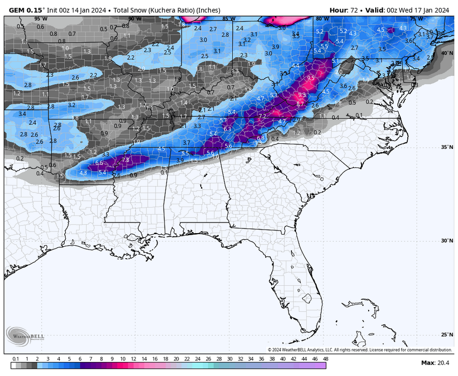
Man, what model is wbir using? Just caught the "futurecast" from them and the moisture and cold looks beefy. No concerns if you are on the NW or SE fringe according to that model. Of course they didn't show any totals yet.
Just found it odd as usually it always seems the news network models are the ones that show the least amount of snow. lol
-
2 minutes ago, Daniel Boone said:
That pretty much shows the print of the higher ratio cold not getting across the Plateau. Even if same amount of QPF falls aa snow there's of course less accs east of Plateau. Hopefully the colder air makes it in over.
So it pretty much makes it a niña like storm? Trying to remember, but seems like there have been a few the past couple of years where the whole state gets snow while the east gets cold rain with the cold air just hanging out on the edge of the plateau. One storm in particular I remember models busted as we got mostly rain here and no snow.
-
1
-
-
Canadian
-
3
-
2
-
-
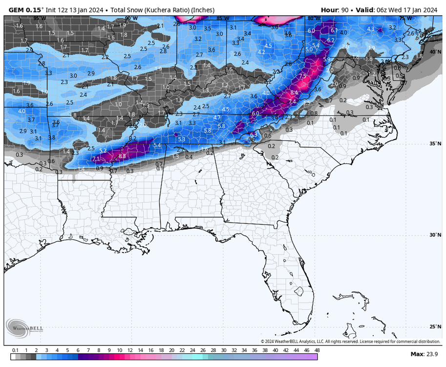
1 minute ago, TellicoWx said:
Definitely flatter....western side ticked north.
Yeah looking at the snow output it actually doesn't look too much different.
CMC is still a little stronger with more precipitation.


January 15th-17th 2024 Arctic Blast/Snow Event
in Tennessee Valley
Posted
I am going to need a drink after looking at the GFS. Goodness!