

Silas Lang
-
Posts
696 -
Joined
-
Last visited
Content Type
Profiles
Blogs
Forums
American Weather
Media Demo
Store
Gallery
Posts posted by Silas Lang
-
-
1 minute ago, Wurbus said:
NAM will do...

I know there is probably a lot of melt and this is with marginal temps, but that's a straight up paste bomb. Goodness the mountains and foothills look to clean up on this run.
-
 1
1
-
-
17 minutes ago, fountainguy97 said:
Anyone have 18z euro maps?
.thumb.png.d79bde90745e5cde6650bac53081cad4.png)
Top is 12z and bottom is 18z for comparison. The latest run gets a little more of the plateau involved.
-
2
-
-
11 minutes ago, fountainguy97 said:
I think NAM has a dry slot over NE TN. It's pretty far west.
18z has come out pretty bland. Icon and NAM and RGEM all bleh. What's with 18z runs? Yesterday was rough too.
what do you guys make of the RGEM being all rain? Its track isn't horrible.
Well there is a bit of a lower precipitation total near JC on that run. That's a possibility. I know these set ups are rate driven.
I think Powell mentioned it this morning that the models sometimes struggle picking up the dynamic cooling aspect of these storms. That could be a possibility as well. Or maybe we just get cold rain. lol
-
1
-
-
NAM shows some mixing and thermal issues. Pretty weird looking clown map. Suggests most go from snow to rain. Just weird to see TRI blanked when the Euro has it getting crushed. Any thoughts?
-
1
-
-
13 minutes ago, Stovepipe said:
The question I have is, when is John leaving to watch the super bowl in Chatty? I'm planning my snowman around that.
Where has he been? I miss his posts. He usually provides some good historical analysis when looking at potential systems.
-
1
-
-
Seems like this thing is trending slower as well. Wonder if we could trend to a more ideal period of snow on Sunday night as opposed to the day time?
-
NAM took a huge step towards the Euro. Way more west.
-
1
-
-
45 minutes ago, fountainguy97 said:
We have a 100mile difference between Euro and gfs today. Euro is NW and much more snow further into TN.
The resolving of this will determine where the heaviest snow sets up this weekend.

Maybe it's somewhere in the middle? Seems the models have done that a lot this winter. Two different solutions with a slow trend towards each other.
-
43 minutes ago, PowellVolz said:
Dynamic cooling. I would expect mods to struggle handling low level dynamics under 2500’. For the valley all we need is low 40’s and good rates. As long as we are within the cold core, the temp dropping 5-7 degrees is nothing. Seen it drop close to 10 degrees before.
.Yeah, agreed. When you look at that Canadian run it looks like most of the east gets under heavy precipitation, but most shows up as rain.
-
1
-
-
Canadian is a beautiful rainstorm with a weird southern plateau jackpot of snow.
-
Will say, at a quick glance it did seem warmer though. Very close temps. Like any closer and this will be a monsoon. lol
-
A tick back to the west on the GFS. TRI and the mountains would love that outcome. Pretty steep cutoff. Wouldn't take a lot to get more people involved.
-
Well 18z Euro was more West and the 0z NAM is more East. Where will the GFS go?
This is going to be rough couple of days. Would rather be too far NW at the moment if I had to choose.
-
1
-
 1
1
-
-
24 minutes ago, fountainguy97 said:

Got love the timing of this thing for us at this juncture. Marginal temps, but middle of the night with potentially heavy rates could make all the difference. You get something on the ground before daybreak and it could help tremendously with accumulation.
-
3
-
1
-
-
1 hour ago, Carvers Gap said:
The 6z Euro ensemble ups totals for E TN and the Plateau. The control is big. The GFS, if it is right, is a NC special. The Euro is not there yet, but it had trouble w/ the last storm. It was far, far too far to the northwest. OTH, the GFS was to far to the SE and blew thermal profiles until the last minute.
Do we want the storm to become stronger to pull more west? What is the mechanism that keeps it towards TN and not too far east?
-
1
-
-
2 hours ago, fountainguy97 said:
These ULL systems are notorious for being a pain. Best to just sit back and see how this looks inside 48hrs.
icon, cmc, euro at 6z are all lock step together with a East TN, App Spine hit.
gfs and GEFS shifted east nearly 100miles at 06z to west NC.
12z should be a good benchmark as we are fully sampled BUT I've seen these get more uncertain at this range instead of more concrete.
Unfortunately cut even kuchera in atleast half due to wet ground, daytime timing, and temps above 32. This is one of those "6" fell but only 2" stuck" type of deals.
Yeah, if I get an inch I will be happy. Any more is gravy. It is also fun to watch as these systems can puke snow.
-
3
-
-
1 hour ago, Reb said:
We should pull a MRX and wait until it’s snowing outside to start a thread. JMO
I'm afraid to even talk about it. lol
If we get a few more runs like this, I do want someone to make a thread. I like having them for historical purposes, boom or bust.
-
5
-
-
Anyone have any current observations?
-
39 minutes ago, Holston_River_Rambler said:
Soundings look ok on the RGEM too, at least for snow, but I guess the question is more of how suppressed will it be? Is this a case where NW precip shield is under modeled?
Yeah, I am curious too. I looked at the upper air temp maps, and they look pretty good for everyone, but there must be a warm layer for the valley. Don't have access at the moment, but could you put up a sounding for Knoxville?
-
Man, why ain't more people posting? Was hoping to see some reports! Pics? Observations?
-
1
-
-
20 minutes ago, footballknox said:
Any chance the cold air continues to move eastward to get the TN valley/ Knoxville area in on the action?
Not really. Even if temps do get below freezing, it would barely get there, and for a short period of time at that. With warm ground temps, I don't think it would really be eventful regardless. This is a West and Middle TN event.
-
2
-
-
1 hour ago, snowmaker said:
Man this place is more dead than when we have boring weather. LOL
Well, a guess a large group of posters in the east aren't too thrilled with a week of cold rain. To be fair, it is a gross, nasty, 40 degree rain. Just a bleak affair here, the grass is practically mud. There are still a few here posting though!
-
3
-
-
15 minutes ago, Carvers Gap said:
Yes, the Plateau is the barrier. That said, even the 12Z Euro is bringing down temps in NE TN and SW VA. I doubt it gets here, but that boundary continue to press. I need to go look at the run2run temp changes.
Yeah, that's what I thought. The cold is definitely pressing. Tuesday into Wednesday it even suggests temps of around 34 in the central valley. The NAM looks to be similar. Still, doubt it based on prior events. It's close though.
-
14 minutes ago, footballknox said:
What prevents the cold air from coming in East TN?
Probably the plateau?
-
2
-

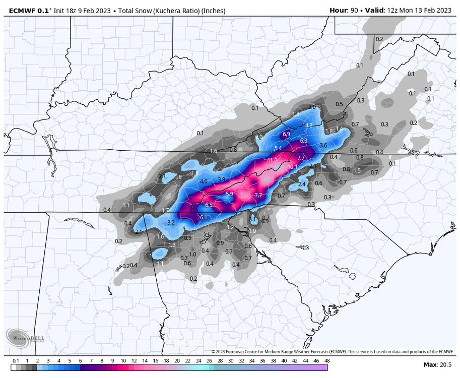
.png.95ab190ad7e57b590a6ec99b515b48ec.png)

February 11-13 ULL event
in Tennessee Valley
Posted
lol yeah, I was just looking at the map on weatherbell and saw the same. A much more reasonable expectation. If I can just get an inch, I will claim victory.
Anyway, to get an idea of how wet this system here is the precipitation map. Looks like Blount, Sevier, and Cocke have a lot of potential. 2 inches of water to work with, though I assume the ratios are low? Less than 10?