

Silas Lang
-
Posts
696 -
Joined
-
Last visited
Content Type
Profiles
Blogs
Forums
American Weather
Media Demo
Store
Gallery
Posts posted by Silas Lang
-
-
6 minutes ago, Carvers Gap said:
The 0z 3k/12k NAM depictions push the ice line southward with each run.
Yeah, I noticed that. Pretty substantial difference in places that were already below freezing as well. 3 to 4 degrees colder. Unfortunately, it makes the risk for ice much worse in places like west and middle TN. If it stays at 31-32, it probably won't be too bad. But if creeps into the upper 20s...
-
 2
2
-
-
1 hour ago, Carvers Gap said:
For me, this winter is a carbon copy of the last three. Chances during December along w/ severe cold. Then, it was a battle from that point onward, but not without opportunities. I think for folks west of the Plateau, this winter (still been better than mine) has been similar to what E TN has seen for three straight seasons. That may be why E TN folks are somewhat apathetic to warmer temps and fewer chances.
Yeah, for this reason I am about to punt next Tuesday's event for the East. West has the best chance of scoring!
-
1
-
-
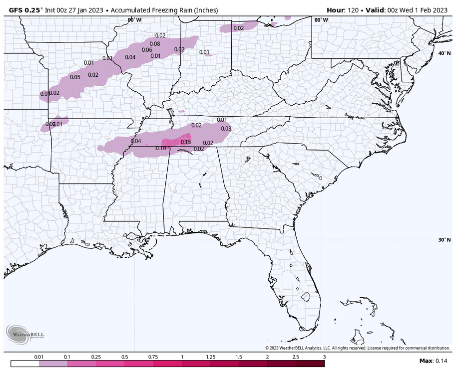
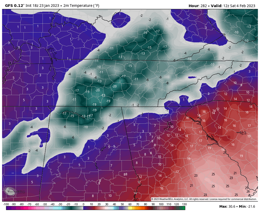
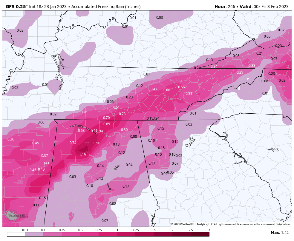
Canadian is a massive ice storm for West and Central TN. Unfortunately not any snow.
-
1
-
 2
2
-
-
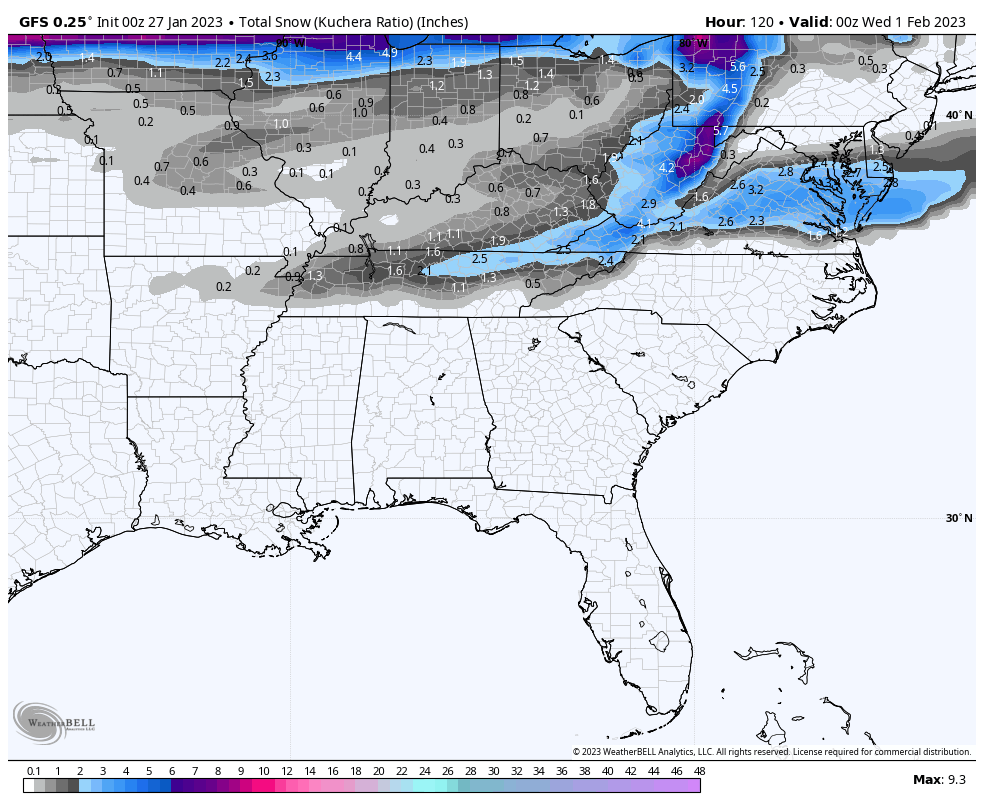
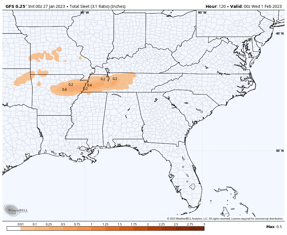
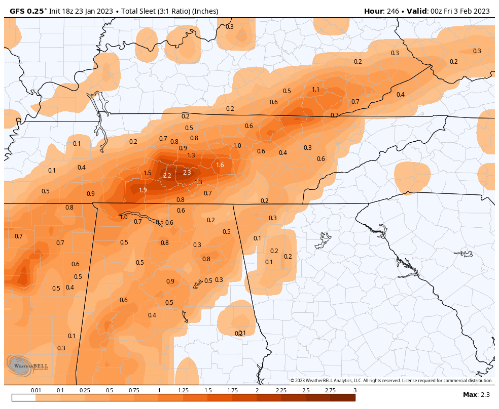
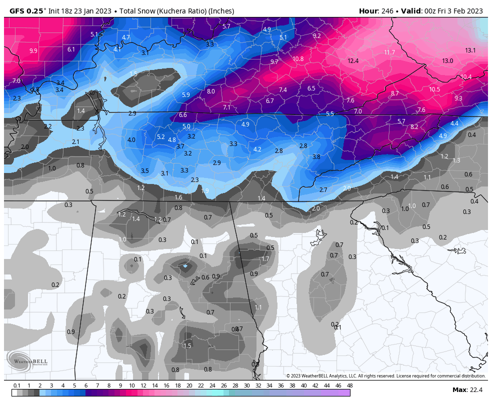
Here is the p type break down. Note that this doesn't include a potential second wave.


-
2
-
 1
1
-
-
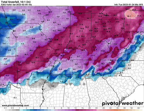
Using the totally valid metric of clown maps, it's pretty easy to see the potential for next week. Nothing crazy, but a statewide 1 to 3 inches doesn't sound unreasonable. I haven't dug in, so I don't how much of this is ice or sleet, but still a winter event regardless. Just need to get a little more southern jog to get the whole state. The trend is good on the GFS!

-
5
-
-
Although looking at the Canadian, it follows more of the pattern we have had this winter of LPs going almost due north to Ohio. Hopefully it's just sniffing glue, but I'm not really sure what's preventing that scenario from happening.
-
I am starting to feel pretty confident for winter weather in the western part of the state. Less confidence as you go east and south. The trend today is further south. It is also nice to finally see something similar on the GFS and Euro. Let's see if it holds or continues.
-
1
-
-
1 hour ago, Carvers Gap said:
Different time frames by just a few hours as both models(12z GFS and Euro) accentuate different waves. 12z is on the left and 0z is on the right.
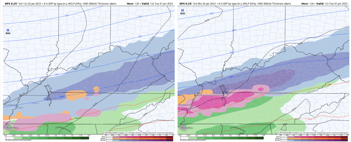
Suppression is the trend. Just need a little bit more! For those in the east, do we want the cold air to be coming from a more North to South angle like the 12z? Seems coming from the west it would be more likely to get hung up on the plateau.
-
1
-
1
-
-
2 hours ago, Carvers Gap said:
There is much to enjoy about following the weather. I just think getting bummed over one run is getting sucked into the vacuum that other forums have dealt with. I used to be swayed like that. However, this is a great hobby, and I have learned to enjoy hunting storms. Maybe it is because I used to fish a lot or I am getting older and know my days are numbered(no, I am not dying...LOL)....some days are great and some aren't. But getting out there on the water is always good. Opening up new model suites is generally enjoyable for me. It is akin to hunting for Easter eggs in a video game for me. Plus, I just enjoy the maps and graphs. Enough analogies. For me the best thing about this winter was standing w/ the local HS band as they were waiting to go into Lucas Oil Field for their national semis run. It was unexpected, and awesome. I never saw it coming on modeling. Sometimes the unexpected things are the best.
...just reminding everyone to enjoy a great hobby and the truly great fellowship of this forum. In about 4-6 weeks, many will head back into hibernation until next season.
I hear you. The chase is part of the fun! I think it also helps to have realistic expectations. We average about 6 inches of snow a year here. Sometimes that means we get it all in one dump (Christmas a couple of years ago), get a few small events, or even nothing one year and 12 inches the next. At least I live in a place where I get to see some snow falling every year, even it it's just flurries or a snow shower. Some places don't even get that.
I think people that are the most miserable with this hobby are those who expect a massive snowstorm every year, are never satisfied with snow amounts, etc. I just want to be like "you live in the south east, stop complaining, and enjoy what you have!" And on the topic of unexpected, what about that Vols football team this year? Simply magical. Never been more invested than when I was a teen in the golden era.
But, yeah this place is great! I really enjoy your posts and all the others that can explain things that I can't. This forum is my free entertainment during the winter.
-
4
-
-
4 minutes ago, snowmaker said:
I was on a Midwest forum during this past storm that cut to our northwest. Most on there said the euro and Canadian handled that storm the best. Of course that is no guarantee how any of them will handle the next one. But I would probably lean euro right now but like to digest all 3 because a lot of times it’s a split the difference type of deal to some degree.
Yeah, I still look at all 3 and figure a split the difference approach is best. But really hard to even split the difference with the way the GFS has been.
4 minutes ago, John1122 said:Ignore them and look out the window with how it's gone this year. But the GFS has been really really bad this year. 3/4th of its runs are wildly wrong but since it changes so much from run to run, it falls into being right at least a few times a week.
Massive investments and upgrades and models have gotten better at seeing storms a long way out but worse at details. Even in close to storm time. The Euro is actually most disappointing in that regard. The GFS was never great but you used to be able to almost lock in a d5 event if the Euro had it a few runs in a row. Now they all miss from 24 hours out if it's regarding frozen events.
I swear, I thought the GFS did great last winter? Like, it seemed like it was out performing the Euro. But now, not so much. Yeah, I remember when Euro (the king) was pretty much a lock. I miss those days. It would be nice if we still had access to those older versions of the models.
-
4
-
1
-
-
6 minutes ago, snowmaker said:
Yes the euro and Canadian seem to not have as wild fluctuations. Not that they don’t but the GFS seems to be leading in extreme run to run changes. At least it did have a boundary of precip in that timeframe even if the temps were way warm and the precip was well south.
Yeah even the Canadian seems more consistent.
Don't know why the GFS has been so nuts lately. It's like a box of chocolates, you never know what you're going to get.
-
2
-
 1
1
-
-
1 minute ago, Matthew70 said:
Unbelievable how the GFS is so bi polar.
Yeah, should we lean more towards the Euro? I don't really know how the models have faired this winter or even how accurate they are with these over running setups. But the GFS has has been a completely different solution each run often this winter.
-
2
-
-
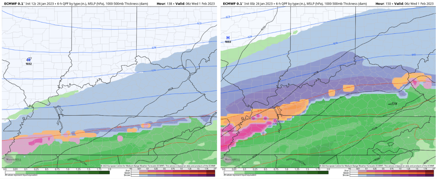
Finally got to see the Euro. System next week looks a little flatter. However, snow over the entire state. Roughly only an inch average with the winner being middle TN and northern plateau with 2 to 3. Much less ice. Last night's run only had snow in the northwest part of the state.
-
1
-
-
Looking at the Euro, it looks like the cold air is pushing a little more south an east, by about 50 to 100 miles compared to the 00z last night.
This is regarding the potential overrunning next week.
-
2
-
-
5 minutes ago, Carvers Gap said:
Yeah, at this range deterministic runs will have a lot of variation. But the signal is what I am looking for. I am just looking for some consistency across modeling that we are in the game, and we are at this point. I also know, that can change in a heartbeat. I once watched 2-4'(feet is right!) modeled for Upstate South Carolina, and it busted badly even during the storm. So, we know the drill. LOL. On a serious note, that amount of freezing rain could be a huge problem, especially w/ the cold which follows on the CMC. Not quite sure I want to reel that one in......
Good lord. What event was that? You hope people understand enough to factor in some climo when looking at snow maps. I don't even know if SC has ever had that much snow in their history. If that was showing on models for the valley, I would give it some serious side eye. 6 to 8 inches is usually the upper end on big events around here, with something like a foot or more being a once in a lifetime storm (like 93).
Anyways, I am a sicko and want to reel this one in. Even after having burst pipes from the last cold spell. I can't help myself. Some men just want to watch the world bu...er umm freeze. Let's see what the Euro brings!
-
5
-
-
38 minutes ago, Carvers Gap said:
And ALL of it could go to the Ohio River valley. That is plausible. However, December is a great example of how it can go the other way - cold and dry. I like the active STJ and cold. That is a good combination for frozen precip in the Upper South, and even Mid-South. Plenty can and will change, but it is worth tracking.
Agree 100%. I am feeling pretty confident that some overrunning will occur. But it could still go anywhere at this point. Really depends on the cold push. I don't think it will miss us south. More likely north. The cold could get hung up on the plateau like the last time we had one of these events. Middle and West TN scored big while it rained here in the East for days. When was that? 2021?
-
2
-
-
17 minutes ago, Carvers Gap said:
Anyone have the 12z Euro run?
Looks like it is delayed. Still just shows the 6z.
-
48 minutes ago, Carvers Gap said:
Right now, all global deterministic models show a similar set-up right after the 200 hour mark. As others have noted, that is a long way out there. For now, I just look at the pattern to see if it supports wintry precipitation. Ensembles are slightly less enthused.
Yeah, the Euro last night looked similar to the Canadian and GFS. Pretty good to have all in agreement on that type of setup with as chaotic as the models have been this season. The pattern looks good, just hope we can score something!
-
1
-
-
10 minutes ago, John1122 said:
Less ice that run vs 18z. Cold but not as insanely cold as the 18z too. I can do without -15.
I didn't even see this second event. Lots of opportunities.
-
2
-
-
Latest GFS looks different, but still winds up with a couple of inches of snow in the east. The Canadian also trying to show something at the end of it's run. Way too far out for specifics, but it is seemingly increasingly likely that there is a storm threat for someone in the southeast next week.
-
1
-
-
14 minutes ago, SnowDawg said:
Longtime lurker here, spend most my time on the SE forum, but here in North GA I'm kinda stuck in between this one and a very carolina centric one over there.
Definitely brings 2015 to mind for me. Had all but given up on winter by the start of February and then in the span of about ten days had three winter storms. First was a heavy ice and sleet event, then a light snow and ice event, and finished with a big Miller A all snow event. No doubt if you can get the setup just right, our hits can come in bunches, even within an otherwise mostly forgetful winter.
Yeah, 2015 was the last real big one I remember. I was in school at the time (student teaching) and I remember I was out for like 3 weeks. lol I forget if it was that year or another previous year, but I remember having some sort of snow/ice mix on the ground for a good chunk of the month of February. It would start to melt, but before it could clear out another storm would come and there were layers of frozen on the ground. Roads were awful for a while.
This setup on the GFS with the the ice, sleet, snow, and cold reminded me of some of the those past setups. Hopefully we can score (but maybe without all the ice). February has always been the best month of winter in my mind.
-
1
-
-
This look reminds me a lot of Feb of years past. Storms with every p-type imaginable only to be followed by another. Can't remember the exact years, but somewhere between 2012 to 2015? Anyone remember? I just know there were a couple of Febs where we had some systems showing pretty much what the GFS just showed.
-
1
-
-
Some pics because I am bored and holding a sleeping baby:


-
3
-
-
4 minutes ago, Carvers Gap said:
18z GFS is a nice run so far to echo Silas.
Yeah, it shows the potential. Even though the some of the other runs haven't shown a storm, the potential is definitely there for something like the GFS is showing. The first of Feb looks like a good window of opportunity.
-
3
-


February 2023 Medium/Long Range Pattern Discussion Thread.....Torch or Tundra???
in Tennessee Valley
Posted
Even in TRI there is some variety in climate. It always seemed Kingsport and Bristol did better with the big storms, and JC was better with NWF and snow shower like setups. I have wonderful memories of randomly getting hammered with a snow shower and picking up an inch of snow while in JC. Best location I have lived in for those types of events.