

Silas Lang
-
Posts
696 -
Joined
-
Last visited
Content Type
Profiles
Blogs
Forums
American Weather
Media Demo
Store
Gallery
Posts posted by Silas Lang
-
-
4 minutes ago, John1122 said:
It may go down in flames but the GFS isn't backing down.
Actually not a bad GFS run. Snow totals were up. It looks like the cold is coming faster if you look at the trends.
-
 5
5
-
-
50 minutes ago, John1122 said:
Very small step on the Euro as well. Wasn't a lot but it was a slight increase from 00z last night. It just cuts everything off really fast. That's actually not super common with powerhouse arctic fronts, they usually squeeze out every last drop of moisture. It just wraps in an incredible amount of dry air. The GFS has 80 percent RH at 700mb over me at 102, the Euro 12 percent RH. The Canadian has 60 percent.
This is a good point. Regardless of how much snow we actually get, there should definitely be some lingering showers and flurries. It will definitely be a good winter day in the least.
-
8
-
-
The LP is in Illinois on this run. It's going to be in Nebraska at this rate. lol
-
 1
1
-
-
1 minute ago, Carvers Gap said:
The other thing to note is the jet streak raging over the TN valley immediately after the low. Let's see if something rides that after the big storm.
Some runs have had little waves of snow after the big system. Honestly could pick up a quick inch or two if we get something small with the cold temps. I remember one little wave after a big storm several years ago where I got a random 3 or 4 inches of snow. Something to watch for sure.
-
2
-
-
41 minutes ago, BlunderStorm said:
We're gonna need a hail mary of an eastward trend, that or some trailing energy once the low wraps the cold in.
Yeah, unless something major changes, I think eastern areas are out. It could still trend better for the west and maybe middle TN.
-
2
-
-
1 minute ago, TellicoWx said:
One more step back on the models and all TN will be out of play (except the normal NWSF areas of plateau/mtns). GFS cave to the Euro/CMC almost complete.
Yeah, it's a shame as the GFS did really well last winter. Looks like Euro will win this one. May be the better model for this winter/pattern.
-
1
-
-
GFS super amped and wound up storm. Ends up cutting further west.
Looking at a statewide dusting on the backend of this thing now. lol
-
1
-
-
1 hour ago, Carvers Gap said:
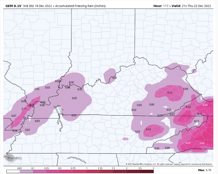
That would be awful with the cold temps following. I do think we might have to be concerned with flash freezing if the cold comes in as quickly as modeled.
-
13 minutes ago, Carvers Gap said:
Additionally, December is rarely our month for snow. It has been recently, but historically the valley rarely scores big snows prior to the fourth week in December. Our best climatology is January to the first week of February. So, we are fighting general climatology as well. NAOs are often the coldest in January and February. In general, it doesn't want to snow in the valleys during December - even old school eras as well.
If I am remembering correctly, I think March is even typically better than December for snow.
-
1
-
-
Looks like a back end mood flake setup for the valley.
-
Less cutting and more coastal this go around
-
2
-
-
4 minutes ago, PowellVolz said:
A friend of mine sent me this….lol, SMH

WHY ARE WE YELLING?
But, seriously this account just took the 6z GFS run and stated it as a forecast. Which is the problem with these accounts.
-
1
-
-
1 hour ago, John1122 said:
I love looking back on these threads to see what went right or wrong. So I'm glad it's here.
I feel like it'll be Tuesday before we have the right idea or something close, on this one.
I will say this, I was reading the CPC talking about model biases and model verification. It noted that the GFS scored much better in what they called "extreme events" and I believe this qualifies. It also noted that all models had a North precip shield being to dry bias West of the Appalachians. Something we've discussed on here for years.
Agreed on having the thread. Boom or bust, it is nice to have to reference. Besides, not like we get many shots some years. May as well enjoy what we get...or don't get!
-
4
-
-
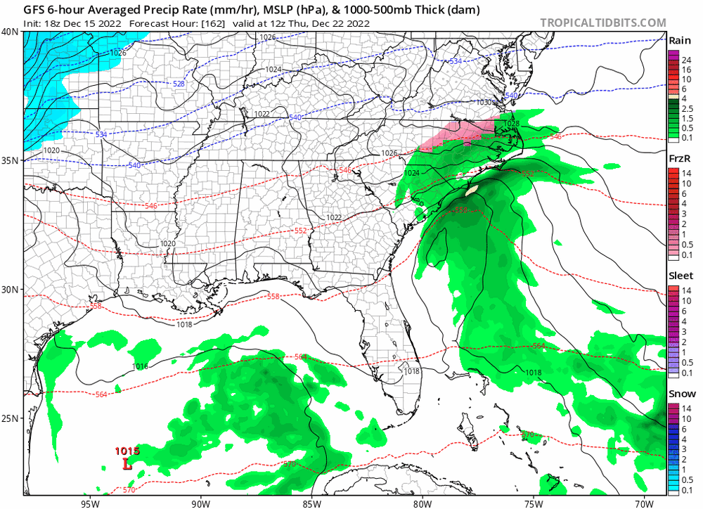
Latest GFS was much better for West and Middle TN. A little concerning for the valley with the LP sitting right on top of it at one point. Still managed to get most of the state. Storm more wound up. Seems like it took a step towards the Euro/CMC. Not a good trend, imo as the storm could end up cutting more if it continues.
-
1
-
-
The GFS has scored some wins the past year or so since the major upgrade, correct? Maybe I am remembering it wrong, but I swear it has seemed more consistent for the past couple of big winter storms.
-
1
-
-
1 hour ago, Carvers Gap said:
I think right now with seven days to go, there is still going to be a lot of variation. With each run new model data is added, which changes the results some. This is also the range in which modeling often "loses" systems (5-7 days). For now, we have an Arctic front rushing into the area and a slp popping on the lee side of the Apps and maybe another on the coast. Spacing could also be an issue. We have gone from almost nothing in the pattern to multiple vortices and waves - lots to juggle. With each tweek of each new vortex, it changes all of it. A Miller A, a frontal wave, overrunning...or nothing. The first three make the most since given the strength of the front to quote John.
My only concern is that systems get crushed by the cold. Is that a possibility? Or are there other dynamics at play from preventing that outcome?
-
1
-
-
27 minutes ago, Carvers Gap said:
6z GFS overrunning event(can't find a better term for the multiple waves....though tech not a 100% overrunning event)
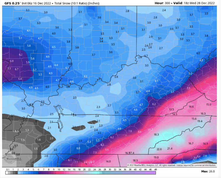
Obviously one run, but this would have to be a record week for East TN if it did occur. Just nuts. While I don't expect this to come to fruition, I do think this does highlight that we have a genuine shot of a great couple of weeks of winter.
And yeah, not overrunning, but not sure what you call those events that happen after Christmas. I think I will just go with amazing. lol
-
1
-
-
A gif for those unable to look at the moment.
-
5
-
 3
3
-
-
Just now, Carvers Gap said:
18z GFS...Yup.
Another big hit!
-
6
-
-
Goodness, I didn't get a chance to check the rest of that GFS until now. Bone chilling temps and some snow showers and another storm trying to pop ( a little late for us) on the 27th. It is below freezing for almost a week as well.
-
2
-
-
21 minutes ago, snowmaker said:
On the GFS it still looks like it is trying to hold that 19-20th wave together more and more but still can’t can’t quite get there yet. Maybe it will. Should be some interesting model runs in the coming days. Hoping for snow on the ground at Christmas!
Yeah, I noticed that wave holding together a little better as well. Need to keep an eye on it. Would be nice to get some snow on snow with the Christmas Eve storm as well. I can't remember how long it has been since we have had snow fall on snow in the valley. Maybe 2013 or 2014?
-
3
-
1
-
-
13 minutes ago, PowellVolz said:
I had 6.5” at my house and just a few miles down the road had 2-3”. Crazy stuff but that’s how it is living in Knox Co.
.There was also a pretty tight East to West gradient for this storm as well. I stayed at my folks in Anderson County and they got about 2 inches while the totals got higher as drove back to my place in Knox. We had 5 inches at the house. That was pretty surprising.
-
3
-
-
Well, this pattern is certainly ripe for some surprises. I've been caught up with the Christmas period and the 18z GFS says, what about next week instead? Seriously seems like something could easily pop up in a few days notice. Not too concerned about details as it seems to be in flux from run to run. Hopefully we can all score the next couple of weeks!
-
3
-
-
11 minutes ago, John1122 said:
The lightning is crazy looking south and north from here. That cell appears to have 2-3 strikes per second.
Yeah, it has been nonstop flashbulbs. Coming up on 3 inches of water. Real impressive storm. My yard is a lake. And it looks like there is a stout line coming in behind it. You should be seeing that soon.
What is the cause of this? The flow? Like the opposite of a rain shadow or something.
-
1
-

Historic Christmas Cold & maybe snow?! Dec 23rd-30th
in Tennessee Valley
Posted
It would be nice for this to hold steady or trend better. Really don't think this will be a huge snow event, but I would be ecstatic with 1 to 2 inches like the GFS was showing. I don't think the ceiling is much higher for most as that would take some major adjustments with the storm path. Guess we just got to hope the cold is as fast as advertised. That doesn't always work out, but it's a possibility.